All Activity
- Past hour
-

Hurricane Erin: 125 MPH - 940mb - WNW @ 14
bugalou replied to BarryStantonGBP's topic in Tropical Headquarters
twitter -
 Hot tamale today
 -
We can look at the SST data for the WPAC over the last 10 years and see that this has been a top down rather than bottom up warming process. The subsurface charts show warming starting at the surface around 10 years ago and gradually working down. It also matches the increase in high pressure and drop in clouds. This is consistent with the warming we have seen in other oceans like the Atlantic following light winds, more sunshine, higher pressure, and fewer clouds.
-
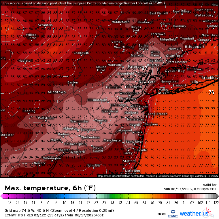
Not anymore unfortunately for the heat and dew crowd. 80 + maybe?
-
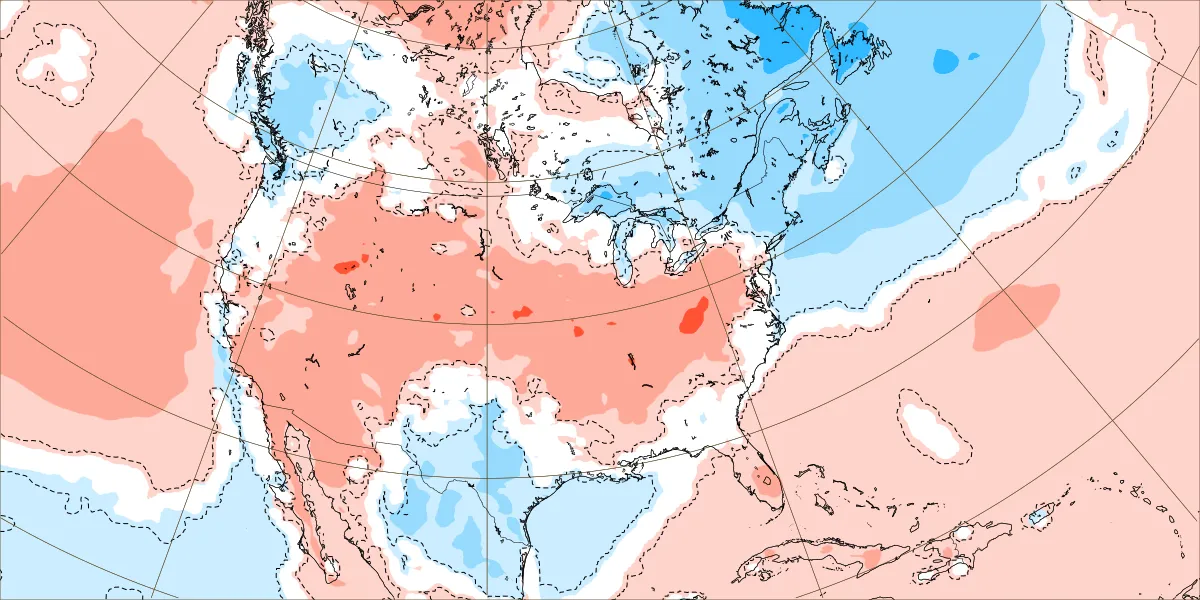
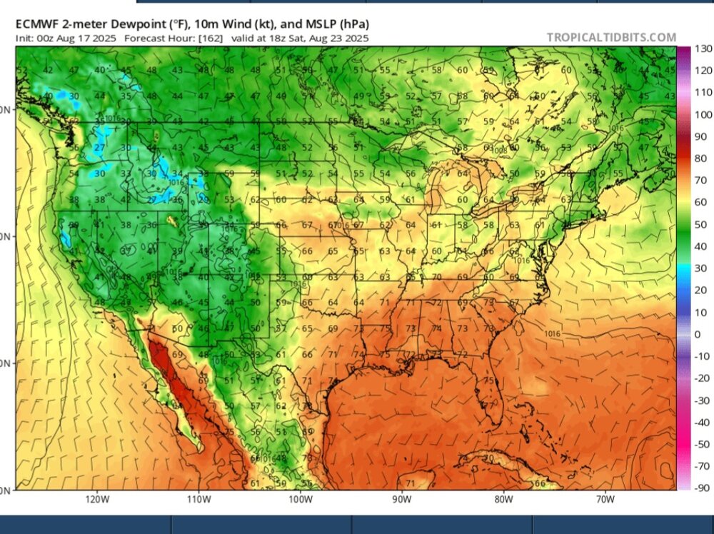
 Looks like we get a break for a while on the mid 90s after today. This week should be very close to seasonable for the temperarures. But unfortunately it still looks drier than normal. August 18-25 forecast

-
I think the last rain of significance at Pit2 was on July 13th when a tiny little cell stalled right over my head and gave a 90-120 minutes of absolute deluge. Horrible after since. August: 0.0. Lawn is brown and crispy.
-
Finally some rain for the Pioneer Valley!
- Today
-
Can you narrow it down further to -NAO/-ENSO (La Niña/cold-neutral) winters? The whole theory was based on years with high ACE and recurving hurricanes during -ENSO’s supposedly causing -NAO blocking during winter
-

Hurricane Erin: 125 MPH - 940mb - WNW @ 14
olafminesaw replied to BarryStantonGBP's topic in Tropical Headquarters
It really looked like the inner eyewall was trying to weaken last night, but now it's seemingly strengthening and the outer eyewall growing larger/weaker. Very strange -

Hurricane Erin: 125 MPH - 940mb - WNW @ 14
wthrmn654 replied to BarryStantonGBP's topic in Tropical Headquarters
6z nhc track is again to far east as models again shift west. -
Hurricane Erin: 125 MPH - 940mb - WNW @ 14
wthrmn654 replied to BarryStantonGBP's topic in Tropical Headquarters
Where did you get that gem?!I love that -
Hurricane Erin: 125 MPH - 940mb - WNW @ 14
wthrmn654 replied to BarryStantonGBP's topic in Tropical Headquarters
-
Pretty wicked non-severe cracks and strobing.
-
Hurricane Erin: 125 MPH - 940mb - WNW @ 14
bugalou replied to BarryStantonGBP's topic in Tropical Headquarters
-

Hurricane Erin: 125 MPH - 940mb - WNW @ 14
LakeNormanStormin replied to BarryStantonGBP's topic in Tropical Headquarters
OBX keep an eye on this one. These wobbles might put them in play if she turns too wide -
That’s what she said
-

Hurricane Erin: 125 MPH - 940mb - WNW @ 14
Windspeed replied to BarryStantonGBP's topic in Tropical Headquarters
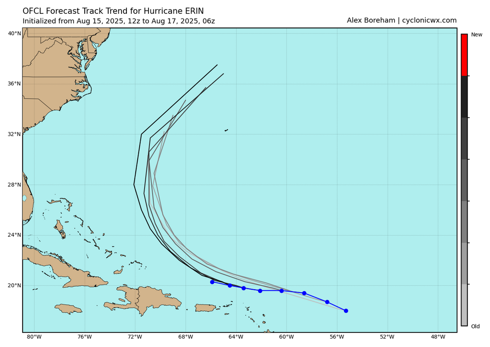
Observing radar the past 12 hours has been fascinating. Erin's small inner eyewall refuses to die. Its ring will weaken for a time, then come back with intense DBZ echoes. Yet, the outer concentric band remains but doesn't appear to be intensifying enough to allow the inner eyewall to finally choke off and collapse. So Erin appears to be in a long-duration replacement cycle. Some mentioning of shear might be the culprit. However, I don't agree with that assessment because these are relatively low values that shouldn't be enough to disrupt the process. We've seen these cycles complete with even moderate shear. I suspect the concentric band is just taking a long time to reach an intensity that would create enough subsidence to do the deed. These processes remain highly unpredictable, statistically, and quite chaotic, so it's really difficult to forecast how an EWRC will unfold with regard to time. Eventually, the outer band should strengthen enough to finish the cycle. But for now, it seems Erin is in a steady state, and the earlier abrupt rise in pressure has stabilized. Erin's RMI should continue to expand, and the hurricane should become quite large. Eventually, we should get a larger eye, and it may clear out. Though I don't think Erin will be able to reintensify enough to regain its peak intensity from Saturday. Especially considering that southwesterly shear should increase by Monday enough to keep it in check. It should still remain a Category 3 or 4 as it increases in size, however. -

2025 Short Range Severe Weather Discussion
TheNiño replied to Chicago Storm's topic in Lakes/Ohio Valley
Had hail damage in may and got wind damage today. Tore off a couple panels of my siding, although admittedly they were probably weakened already and this was just the final straw. Wasn’t home when it happened so can’t give any estimated wind speeds. Glad I’m a renter this year but still a pain in the butt. Definitely was not expecting that today especially since we were never warmed for anything. Been a fantastic light show over the lake tonight. -

2025-2026 ENSO
donsutherland1 replied to 40/70 Benchmark's topic in Weather Forecasting and Discussion
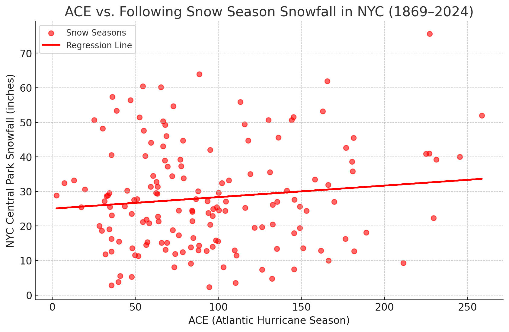
The ACE connection is somewhat positive but very noisy for Central Park.
-

NEW DISTURBANCE: Central Tropical Atlantic (0/20)
GaWx replied to BarryStantonGBP's topic in Tropical Headquarters
0Z UKMET vs 12Z:-AOI forms 30 hours later and then is barely N of the N Leewards (~300 miles to the SW of prior run at same time). -Although Erin still recurves at 74W at same time as prior run had it, it after 120 hours exits much faster to the ENE. At hour 156, it’s already to 54W vs only to 65W on the prior run. So, then Erin on the 0Z is ~1,600 miles NE of the AOI vs ~1,000 miles NNW of the AOI on the 12Z at 168. -Regardless, the AOI is moving NNW at 168 suggesting it’s likely recurving well E of the SE US:NEW TROPICAL CYCLONE FORECAST TO DEVELOP AFTER 132 HOURSFORECAST POSITION AT T+132 : 18.6N 61.9WLEAD CENTRAL MAXIMUM WINDVERIFYING TIME TIME POSITION PRESSURE (MB) SPEED (KNOTS)-------------- ---- -------- ------------- -------------1200UTC 22.08.2025 132 18.6N 61.9W 1008 300000UTC 23.08.2025 144 19.3N 63.8W 1007 291200UTC 23.08.2025 156 20.1N 65.9W 1006 360000UTC 24.08.2025 168 22.3N 67.1W 1005 42 -
Too many Anthony's in my family Antonio It's part of my last name
-

Hurricane Erin: 125 MPH - 940mb - WNW @ 14
Snowlover11 replied to BarryStantonGBP's topic in Tropical Headquarters
sharp wobble southwest. -
Not even mocking the weenies who keep hanging on to the tiniest little piece of “positive” change? That always seems fun.
-

Hurricane Erin: 125 MPH - 940mb - WNW @ 14
WxWatcher007 replied to BarryStantonGBP's topic in Tropical Headquarters
Great thing about being in radar range is you can track the wobbles