All Activity
- Past hour
-

New Years Day 2026 - 1st snows of the new year possible
TheSnowman replied to Baroclinic Zone's topic in New England
I missed this one Today Sleeping. I Missed That one being in LA. And I LOVE Squalls. So Great. A Total S**t Start to the year to continue from the beginning of winter, to go along with the 5th STORM IN A ROW Northeast RI gets Less than most everyone. -

January 2026 regional war/obs/disco thread
Typhoon Tip replied to Baroclinic Zone's topic in New England
I've been in a step back orbital perspective on matters as of late. It's almost like these mid winter dildo smacks upside the head are really like taking a canonical January thaw, and stretching to 5 weeks. Almost symbolically... but could be argued in more practical reality, too. I can't ...well, I'm not prepared at this time to say that's en route again, but we're staring down the barrel of a warm up that seems to be getting sturdier in the guidance - planning ... perhaps "hoping" being more apropos, that it is prelude to a -EPO--> +PNA correction later on, and having the last 9 or 10 fuck ups in mind isn't lending much confidence that all that will really sort out in our favor. In fact, the GFS out to 360+ hours is trying to skip the latter correction aspect - trying to. I dunno, you tell me. I'm fighting the urge to bring up the January sputtering prediction I made back in September. Admittedly, it was half glib at the time. Sort based upon (last decade of mid seasons)+(CC sarcasm)/2 ... so doesn't really count as 'in the race' with other more constructive seasonal forecast ... LOL no. but still, what the fuck I know I come off as heavy handed about y'all taking too much emotional/dopa hit reliance on this shit, but in all honesty, I don't want sit through the next 67 days of no reason to check in at all. ha -
MHT closed out Dec -6.1F/17.9" snow. CON -5.2F/12.7" snow. MHT seems total seems little high but they have an on-site observer last I knew.
-

January 2026 Short/Medium Range Thread
Weatheriscool replied to John1122's topic in Tennessee Valley
Another soaker run on the GFS for the region -
Hopefully it verifies.. it’s been too cold.
-

January 2026 regional war/obs/disco thread
Sey-Mour Snow replied to Baroclinic Zone's topic in New England
The cold first week in January. There still could be two light snow threats as well this coming week. He had a post saying pretty much there is no cold in sight in January. I disagree, yes we can all agree on week 2. -

2025-2026 ENSO
donsutherland1 replied to 40/70 Benchmark's topic in Weather Forecasting and Discussion
I agree regarding the TNH+ and NAO. However, at least as far as January is concerned (1980-2025), the NAO was < 0 on 63% of days when the EPO was < 0. Since 2015, that figure was 72%. A larger period beyond January 1-31 is likely involved in the linkage between EPO- and NAO+. -

12/31-1/1 Possible Snow Showers/Squalls to Start 2026
Wxtrix replied to bncho's topic in Mid Atlantic
the first one was about 45-60 minutes before the line came through and the second one was after we'd settled back to sleep after the squall, lol. Martinsburg gusted to 43. -
December 2025 Avg max: 26.5 -4.2 Mildest: 49, 19th Avg min: 6.8 -6.6 Coldest: -18, 9th Mean: 16.7 -5.3 3rd coldest (#1: '17, #2: '13) Precip: 3.85" -0.98" Wettest: 1.26", 19th Snow: 22.4" +3.0" Biggest: 8.0", 24th Deepest pack: 10" 24, 25 2025 YEAR Avg max: 52.24 -0.35 Hottest: 92, 6/24 and 8/12. Tied for hottest in June, hottest day in August. Avg min: 31.54 +031 Coldest: -19, 2/2 7th year w/o -20 or colder (Also, 3rd year bottoming at -19.) Mean: 41.96 +0.05 (Some illogic, can't find why.) Coldest year since 2019. Precip: 37.22" -11.61" 2nd driest year, only 2001 had less. Wettest day: 1.53" 9/25. 9 of 12 months were BN. Snow (calendar year) 70.0" -18.8" Biggest: 12/24 2025 had perhaps the fewest of standout events of our 27 full years here. No double-digit snows, no 2"+ rains, the fewest days with thunder (5, previous low was 8, average is 15), no especially heavy winds. Ironically, the only real standouts were the hot days in June and August, especially the heat wave of August 11-13, only the 2nd one here - in the coldest year of the most recent 5. The very low precip doesn't fit my idea of "event" - more like watching grass grow. Fortunately, we had no problems with our shallow dug well, though the garden suffered, as my late-June total knee replacement hindered my ability to overcome the lack of rain.
-
IMO it never made sense with the EPO spike which many of the individual members showed and the GEPS/GEFS had.
-
2025-2026 ENSO
donsutherland1 replied to 40/70 Benchmark's topic in Weather Forecasting and Discussion
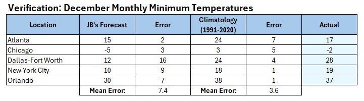
Verification:
-
ouch
.thumb.gif.1da43377e19543ceddff57a86be3914e.gif)
-
GFS with a horrific SE ridge/Cutter run with no end in sight. CMS says what?
-

January 2026 regional war/obs/disco thread
SnowGoose69 replied to Baroclinic Zone's topic in New England
My friend is trying to convince me to go. We have not been back up there for snow in like 20 years. The HREF probs show is mostly where you mention though the 12Z high res guidance models today now largely want to focus it more N of there til tomorrow which is a bit of a delay -
 Question for those in the know: Since urban heat island is a thing - has there been a concerted effort to place sensors specifically in non-urban areas? If not - it seems like there should be. Of course some areas could transition from non-urban to urban over the course of decades, but such an effort/project would presumably account for this - putting sensors in areas that are protected and would never becomes urban (national parks, wildlife refuges, etc.) and/or just remove any sensors that have become urbanized from the data sets. As it is - it seems like threads like this one - "XXX city sees record warmth", are of questionable veracity; to me what would be more meaningful would be "Badlands NP sees record warmth" or the like. (at first I started using Yellowstone as example but then realized it has its own non-urban heat island)
 -
January 2026 regional war/obs/disco thread
Sey-Mour Snow replied to Baroclinic Zone's topic in New England
Happens every year. -
January 2026 regional war/obs/disco thread
Typhoon Tip replied to Baroclinic Zone's topic in New England
actualy only 4half days -

New Years Day 2026 - 1st snows of the new year possible
amarshall replied to Baroclinic Zone's topic in New England
In Wayland at the brother in laws about an inch here . Heading home now . -

January 2026 regional war/obs/disco thread
Baroclinic Zone replied to Baroclinic Zone's topic in New England
Don’t tempt me John… -

Central PA Winter 25/26 Discussion and Obs
Mount Joy Snowman replied to MAG5035's topic in Upstate New York/Pennsylvania
My .3” of snow came to .02” liquid. Pork roast is in the slow cooker. Time for some football. -
As of now, I’m seriously doubting that we see -NAO blocking to go along with the anticipated -EPO/+TNH pattern later this month. +TNH very strongly favors a +NAO/+AO/SE ridge regime as both @40/70 Benchmark and Eric Webb mused. Also, @StormchaserChuck1 found a very strong tendency for a positive NAO when the EPO is negative the last 10 years….
-
January 2026 regional war/obs/disco thread
Baroclinic Zone replied to Baroclinic Zone's topic in New England
Road trip to upstate NY for some epic LES coming? Could be some prolific totals in the Fulton area. -
Acceptable.
-
CWG January forecast: https://archive.is/ECHhk
-

January 2026 regional war/obs/disco thread
qg_omega replied to Baroclinic Zone's topic in New England
Deep winter with pack before we torch in the climatological heart of winter


.gif.d6b6de2dcb2b4ff756c4f853e53581b2.gif)


