All Activity
- Past hour
-

2026-2027 Super El Nino
40/70 Benchmark replied to Stormchaserchuck1's topic in Weather Forecasting and Discussion
Shocking that only one of us in this thread has a history of being 5 PPD...can't possible think of why. -
 Think first half August warm.
 -
2026-2027 Super El Nino
40/70 Benchmark replied to Stormchaserchuck1's topic in Weather Forecasting and Discussion
Larry, I don't see the issue with reenforcing the fact that this July has been. ore representative of the -PDO data set and it has the developing super El Niño. -
2026-2027 Super El Nino
40/70 Benchmark replied to Stormchaserchuck1's topic in Weather Forecasting and Discussion
What? Why don't you formulate a cohesive counter to the point rather than deflecting with silly attempts to inject race into the issue and copy and past a slew of tweets. I'm a licensed social worker with 4 African children and an African wife, who was mocking your proclivity to scan every crevice of the internet for tweets to quote that fit your bizarre ENSO agenda. -

2026-2027 Super El Nino
GaWx replied to Stormchaserchuck1's topic in Weather Forecasting and Discussion
Folks, this thread has had great met. discussion recently. Please don’t let it get out of hand. Because this is my favorite met. thread at this BB, I’d appreciate it if the El Niño banter thread were used instead for certain posts, which is easy to do by quoting a post from here and responding to it at this link: -
 I’d take it.
 -

2026-2027 Super El Nino
snowman19 replied to Stormchaserchuck1's topic in Weather Forecasting and Discussion
Is that supposed to be a racist comment? Seasoned mets who don’t speak English from other countries are stupid and aren’t qualified to comment in their own language? Their posts are useless because they aren’t from here? Horrible, insensitive/bigoted post from you. This El Niño is extremely well coupled: “We are witnessing in the field today the process I described at the beginning of May: as the ITCZ’s active core settles over the Pacific, the convective envelope strengthened in phases 6–7 of the MJO is fueling successive westerly wind burst pulses in the Western–Central Pacific. This injection of westerly momentum weakens the trade winds, carries equatorial Kelvin waves eastward, and deepens the thermocline in the east, thereby accelerating surface warming. Thus, the strong temperature excess that begins in the coastal/eastern Pacific spreads into the basin along Niño 3–3.4; as the Walker circulation breaks down, the Bjerknes feedback kicks in. In short, the atmosphere is no longer merely responding to the warm ocean—it is amplifying it: the coastal-origin, east-central weighted pattern is advancing step by step toward the Super El Niño threshold. Additionally, since El Niño modulates +tropical forcings during this period, it carries a distinct signature in mid-latitude response composites.” https://x.com/atmoslabwx/status/2075960267096100992?s=46&t=NChJQK9_PUjA1K7D2SMojw -
2026-2027 Super El Nino
40/70 Benchmark replied to Stormchaserchuck1's topic in Weather Forecasting and Discussion
For the record, this is worse for winter than a classic super El Niño look...I have no interest in MC influence for the coming winter, but I have even less interest in cherry picking data. -
2026-2027 Super El Nino
40/70 Benchmark replied to Stormchaserchuck1's topic in Weather Forecasting and Discussion
Hey @snowman19, maybe you find find some tweets in Swahili that will convince us this July has shaped up like this. -

E PA/NJ/DE Summer 2026 Obs/Discussion
Birds~69 replied to PhiEaglesfan712's topic in Philadelphia Region
83F/DP 64F Mid week heat wave appears to be short lived w/Wed probably being the most intense... -
2026-2027 Super El Nino
40/70 Benchmark replied to Stormchaserchuck1's topic in Weather Forecasting and Discussion
The fact that we still have a very healthy -PDO in place tells me this El Niño has some work to do with respect to vanquishing the competing MC influence, regardless of how man posts we can find on the internet suggesting otherwise. -
 Obviously this isn't going to impact many posters here and the population density isn't as high, however, this potential is deserving of its own thread. The potential exists for a rather significant severe weather event either late Tuesday afternoon or evening/overnight across northern New England. Daytime temperatures are expected to climb well into the 80's within the region and probably some spot 90's with dewpoints pushing into the lower 70's. This combination under the presence of an elevated-mixed layer characterized by mid-level lapse rates on order of 7+ C/Km will result in an extremely unstable atmosphere with MLCAPE values pushing or exceeding 3000 J/KG. While the timing of this event may be more evening or overnight, instability values will drop off due to the loss of daytime heating, however, MLCAPE values should remain around 1500+ J/KG. With the region on the northern periphery of a stout mid-level ridge that is centered over the northern Plains, strong flow will overspread the region with 60-70+ knots of 500mb flow, aiding in the potential for bulk shear values exceeding 50 knots. In addition, a strong surface cold front will be diving south. The combination of instability and wind shear ahead of the approaching cold front will set the stage for the development of one, or perhaps multiple clusters or lines of thunderstorms across Quebec which propagate across northern New England late in the day or during the evening or overnight. Given the ingredients, the potential exists for a concentrated swath of damaging wind gusts (perhaps some significant wind gusts), and if any supercells develop there will be a risk for large-to-very large hail, and even the risk for a few tornadoes (though this is largely dependent on storm mode and whether surface winds can remain more southerly ahead of the front.
- 1 reply
-
- 1
-

-
 The first 15 days of August 1988 were brutal in New England. I think I had 13 of 15 days AOA 90 and the other two 89. Then a strong cold front came through and the rest of the month avg slightly below for temps.
 -
2026-2027 Super El Nino
snowman19 replied to Stormchaserchuck1's topic in Weather Forecasting and Discussion
“40 knot westerly wind anomalies potentially emerging right over the warmest water east of the dateline. The synoptic elements are too small scale to be accurately predicted here. What it's indicating is enhanced risk of seasonally extreme equatorial westerlies through the middle and into the end of July.” SOI: 30 day: -23, 90 day: -16 EPAC TC season has started: -
 00z euro was really hot up here. 12z gfs goes from 24C to 0C up near CAR. Could be a couple chilly nights for the rad pits.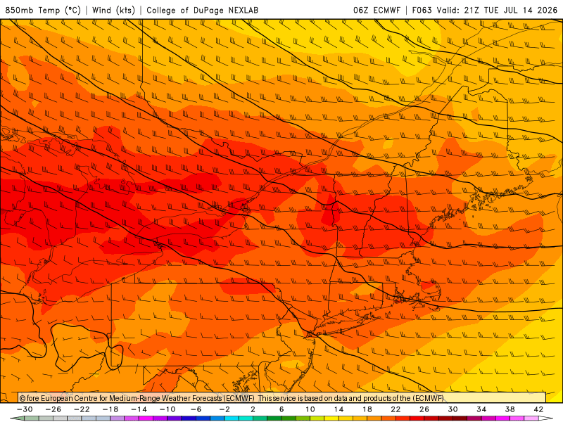
-
If you play hoops, then you know that this is goat-level weather (near 80, mostly cloudy/partly sunny, and mostly calm winds). I loved the desert sun, but it was breezy (unusually breezy) and obviously dry almost every day.
- Today
-
.thumb.gif.f92b16c631a1d15d405ed77b33f0710d.gif) Zero staying power though
Zero staying power though -
Yep - it’s always the most likely scenario when outlooked that far out. Things will almost always trend earlier or later and either direction can of course be worse for timing.
-
Raining hard here again- every day since July 4 has now had measurable rainfall IMBY
-
Nice day for business suits. Up to 75F already from a low of 48F.
-

Central PA Summer 2026 Discussion/Obs Thread
Blizzard of 93 replied to Voyager's topic in Upstate New York/Pennsylvania
My dew point is finally down to 68 now. I am really looking forward to the brief break today from the swampy conditions before the extreme heat returns mid week. -
Currently 78 in town (even on the shoreline), 80 at the TH arprt @ 9:30 am. And so it begins. Lets see if we can hit 100 in the area. WX wise that'd be awesome. Practically, ISH!
-
 Keeping an eye on Tuesday night up here in Maine for bangers. Hopefully the timing can speed up to take advantage of max instability because other parameters are impressive.
 -
Should have a nice long break from mowing in about a week or so as the lawns will start to fry up. Already been over a week without a drop of rain, and a long string of 90s on the way.
-
July 12 1863: Unseasonably cool temperatures are felt across the state. Frost is reported in the Twin Cities area. For Sunday, July 12, 2026 1951 - The Kaw River flood occurred. The month of June that year was the wettest of record for the state of Kansas, and during the four days preceding the flood much of eastern Kansas and western Missouri received more than ten inches of rain. Flooding in the Midwest claimed 41 lives, left 200 thousand persons homeless, and caused a billion dollars property damage. Kansas City was hardest hit. The central industrial district sustained 870 million dollars property damage. (The Kansas City Weather Alamnac) 1980 - Lightning struck a large broiler house in Branford, FL, and the ensuing fire broiled 11,000 nearly ready broilers. Firemen were able to save a few thousand chickens, however. (The Weather Channel) 1987 - Cool air invaded the High Plains Region. Eight cities reported record low temperatures for the date, including Sheridan, WY, with a reading of 37 degrees. Thunderstorms developing along the cold front in the central U.S. produced 6.5 inches of rain at Fort Dodge, IA, and 2.5 inches in one hour at St. Joseph MO. (The National Weather Summary) 1988 - Evening thunderstorms produced severe weather over the Dakotas, including baseball size hail at Aberdeen, SD, and softball size hail near Fullerton, ND. Thunderstorms produced heavy rain in Arkansas and northeastern Texas, with 6.59 inches reported at Mesquite, TX, in just an hour and fifteen minutes. Garland, TX, reported water up to the tops of cars following a torrential downpour. (The National Weather Summary) (Storm Data) 1989 - Early morning thunderstorms over eastern Kansas deluged McFarland with more than six inches of rain. Afternoon thunderstorms in Wyoming produced up to eighteen inches of dime size hail near Rock Springs, along with torrential rains, and a three foot high wall of mud and water swept into the town causing more than 1.5 million dollars damage. Evening thunderstorms produced severe weather in Oklahoma and Arkansas, deluging Dardanelle, AR, with 3.50 inches of rain in less than twenty minutes. About seventy cows were killed when lightning struck a tree in Jones County, TX. (The National Weather Summary) (Storm Data) Observances: 12 Sun National Simplicity Day 12 Sun Malala Day 12 Sun Orangemen's Day (The Twelfth) 12 Sun Etch A Sketch Day 12 Sun National Different Colored Eyes Day 12 Sun National Eat Your Jello Day 12 Sun National Hair Creator’s Day 12 Sun National Pecan Pie Day 12 Sun National Tile Repair Day 12 Sun New Conversations Day 12 Sun Night of Nights 12 Sun Paper Bag Day