All Activity
- Past hour
-
And the latest Canadian ensemble maintains the same drought region for the next 10 days:
-
Damn you just beat me too it. I was too busy looking at the 500mb and surface maps to guess how much we'd get. Tbh I expected a bit more with such a textbook look but the storm moves quick
-
AMAZINGLY(and I use that word sparingly), models kind of settled down today after 300. Check out the 12z Euro and GFS at 360. That is a really great pattern. The good thing is the Euro gets there pretty quickly. With the Jan 2 trough, the Euro never really lets the ridge come back East. It simply retrogrades the ridge further west with each passing vortex -> that is probably the most likely scenario. Simply put the map in motion at 500, and watch the ridge keep popping up further west.
-
It's also vodka cold afterwards. High on Jan 11 is 15F in DC.

-
Get used to disappointment. We are always in the model bullseye here.
-

January 2026 regional war/obs/disco thread
weathafella replied to Baroclinic Zone's topic in New England
I’ve been kind of concerned that in the long range eps Canada loses the deep cold. Some signs of a reload beyond 360 but I don’t feel optimistic when the coldest air is on the other side of the pole. -
Among other things, it led to serious deforestation of the island for firewood. https://www.gothamcenter.org/blog/war-weary-nature-environment-british-occupation-and-the-winter-of-1779-1780
-

Central PA Winter 25/26 Discussion and Obs
canderson replied to MAG5035's topic in Upstate New York/Pennsylvania
...WIND ADVISORY IN EFFECT FROM 9 AM MONDAY TO NOON EST TUESDAY... * WHAT...West winds 15 to 25 mph with gusts up to 55 mph expected. * WHERE...Columbia, Dauphin, Lancaster, Lebanon, Montour, Northumberland, Schuylkill, Sullivan, and York Counties. * WHEN...From 9 AM Monday to noon EST Tuesday. * IMPACTS...Gusty winds will blow around unsecured objects. Tree limbs could be blown down and a few power outages may result. -

Central PA Winter 25/26 Discussion and Obs
Jns2183 replied to MAG5035's topic in Upstate New York/Pennsylvania
Wasn't that one the main reasons after access to water that valleys were settled instead of the plateau 10 miles away? Sent from my SM-S731U using Tapatalk -
At this range, looking too cold is usually a good thing.
-

Ice Ice Baby December 28-29 Storm Discussion
WxWatcher007 replied to Baroclinic Zone's topic in New England
Ice canceled here by BTV. Went from .35 expected to .08 lol. -
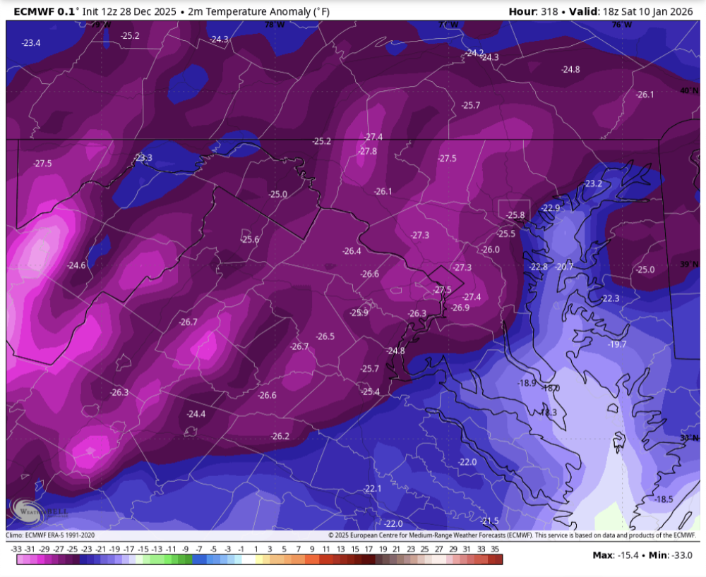
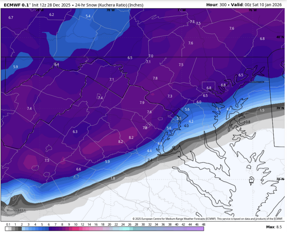
12z Euro major winter winter storm Jan 9-10, general 4-8"
-

January 2026 regional war/obs/disco thread
Ginx snewx replied to Baroclinic Zone's topic in New England
Ya ok. You told us the clipper was a Miller B -
It looks like it juiced up the clipper for nyd.
-
What about the human drama of weather watching?
-
Congrats northern jersey?
-
As long as the blocking stays , we will be good. The models do show that along with it decaying slowly. Watch out for the first week of January for a big east coast storm. Geps has a big signal along with the euro.
-

January 2026 regional war/obs/disco thread
cleetussnow replied to Baroclinic Zone's topic in New England
We may have enough winter peak climo to fight off warm anomalies. I see what the pope is saying wrt to warmth, at the same time the pattern looks good. -
It’s really encouraging to see that classic southern slider footprint present in the long term snowfall means. I just hope we don’t get too much cold press and suppress everything but with the southern jet looking as active as it does, we’re likely to see some really amped storms to balance things out.
-

E PA/NJ/DE Winter 2025-26 Obs/Discussion
The Iceman replied to LVblizzard's topic in Philadelphia Region
Looking like a chilly week after Monday.
-
The 12z Euro eventually traps cold air "under" (latitude speaking) the block. It gets a bit wonky, but (and it might be wrong still) it kind of makes more sense than the other stuff we have been seeing. That IMHO makes a lot more sense than the tendency for an Alaskan vortex that deepens to a point that it is creating a temporal vortex which rips space and time, and empties Canada of cold.
-
Eps, as usual, are a miss tonthe north for the 8th/9th.
-
Lock it in! I can't remember the last event that RDU came in with 6 or greater. December 2018 might be it.
-
As mentioned by other posters the time period after this particular storm signal look to be more promising but I really cant help but like this depiction for the 4th. We have a good amount of vorticity to our south, a block to our north, and surface low pressure across Georgia in a position to bring in both gulf and Atlantic moisture. Of course, as depicted the bowling ball to our north would suppress the storm but for a week out I really can't hate it. We just need to see the trends but as it currently stands it is more than trackable.
-
Boxing Night Snow/Sleet/Ice Dec 26-27 Storm Thread/Obs.
The Iceman replied to Mikeymac5306's topic in Philadelphia Region
Speak for yourself, I got my only underage drinking charge at a bowling alley