All Activity
- Past hour
-
Low of 44 after 3 nights of 36,35.5 and 38
-

Winter 2026-2027 Seasonal Outlook
GaWx replied to WinstonSalemArlington's topic in Southeastern States
The CFSv2 for the last 2 months worth of daily 10 day mean runs has been persistent in showing Feb ‘27 to have an extreme couplet of a much warmer than normal E Canada and a cold dominant CONUS. No other mid-Oct. 10 day CFSv2 mean (back to 2012, it’s first one) has shown anything anywhere close to this, which has not only 80% of Conus BN but also a very mild E Canada acting as a very strong block: In this post in the main forum, I compared this mid-Oct CFSv2 forecast to all other CFSv2 mid-Oct forecasts for Feb and its implications regarding what may actually happen in Feb ‘27: Aside: @buckeyefan1would you mind pinning this winter outlook thread? It is getting relatively little viewing and thus few posts due to being so far down on the topics list even after a recent post since 5 other threads have already been pinned.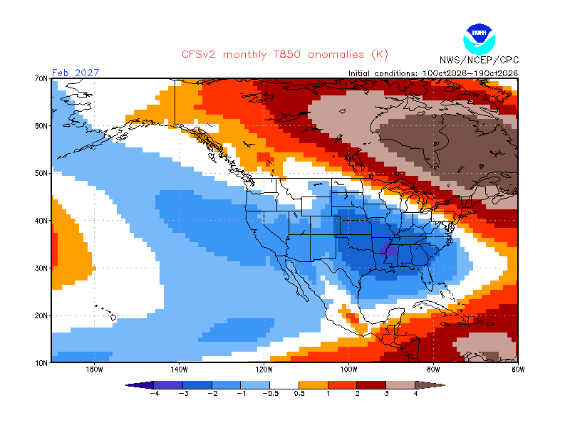
-
Reminds me of that one summer a few years ago where the skies were cloudless for like two weeks. It was insane. First time in my life experiencing that.
-

E PA/NJ/DE Autumn 2026 Obs/Discussion
Birds~69 replied to PhiEaglesfan712's topic in Philadelphia Region
Raking leaves? Trees are generally still full w/some signs of color change around here. If a human actually included/wrote that...he/she is clueless. 56F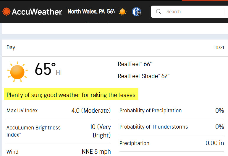
-
October 21 1916: A three-day blizzard ends. Also, a sharp temperature drop occurs at Bird Island, falling from 65 to 13. For Wednesday, October 21, 2026 1934 - A severe windstorm lashed the northern Pacific coast. In Washington State, the storm claimed the lives of 22 persons, and caused 1.7 million dollars damage, mostly to timber. Winds, gusting to 87 mph at North Head WA, produced waves twenty feet high. (David Ludlum) 1957 - The second in a series of unusual October storms hit southern California causing widespread thunderstorms. Santa Maria was drenched with 1.13 inches of rain in two hours. Hail drifted to 18 inches in East Los Angeles. Waterspouts were sighted off Point Mugu and Oceanside. (20th-21st) (The Weather Channel) 1987 - Cold arctic air continued to invade the central U.S. Eleven record lows were reported in the Great Plains Region, including lows of 12 degrees at Valentine NE, and 9 degrees at Aberdeen SD. Temperatures warmed rapidly during the day in the Southern and Central Plains Region. Goodland KS warmed from a morning low of 24 degrees to an afternoon high of 75 degrees. (The National Weather Summary) 1988 - Joan, the last hurricane of the season, neared the coast of Nicaragua packing 125 mph winds. Joan claimed more than 200 lives as she moved over Central America, and total damage approached 1.5 billion dollars. Crossing more than 40 degrees of longitude, Hurricane Joan never strayed even one degree from the 12 degree north parallel. (The National Weather Summary) (Storm Data) 1989 - Unseasonably cold weather continued to grip the south central and southeastern U.S. Twenty cities reported record low temperatures for the date, including Calico AR with a reading of 26 degrees, and Daytona Beach FL with a low of 41 degrees. Squalls in the Great Lakes Region finally came to an end, but not before leaving Marquette MI buried under 12.7 inches of snow, a record 24 hour total for October. (The National Weather Summary) Observances: 21 Wed National Pets for Veterans Day 21 Wed Back to the Future Day 21 Wed Global Dignity Day 21 Wed National Apple Day 21 Wed National Reptile Day 21 Wed National Medical Assistants Day 21 Wed American Frog Day 21 Wed Celebration of the Mind Day 21 Wed Count Your Buttons Day 21 Wed Everyone Writes Day 21 Wed National Archives Day 21 Wed National Check Your Meds Day 21 Wed National Pumpkin Cheesecake Day 21 Wed Reptile Awareness Day 21 Wed Global Iodine Deficiency Disorders Prevention Day 21 Wed Get to Know Your Customers Day
-
My station isn't in a dendrite-advised-or-approved location so the direct sun likely skews the temp a bit, but it was a fabulous day nonetheless!
-
Gotta say...the bots have been quite impressive with pattern recognition and just an overall better idea of the general idea of the larger-scale storm details (development, track). Certainly enough I think to give a big boost in confidence for medium-range forecasting. Not entirely sure about the inside 48-hours or storm specific details but they've been a big boost in the medium-range for sure.
-
the epac is warmer than the wpac. that's outrageous
-
unfortunately
-
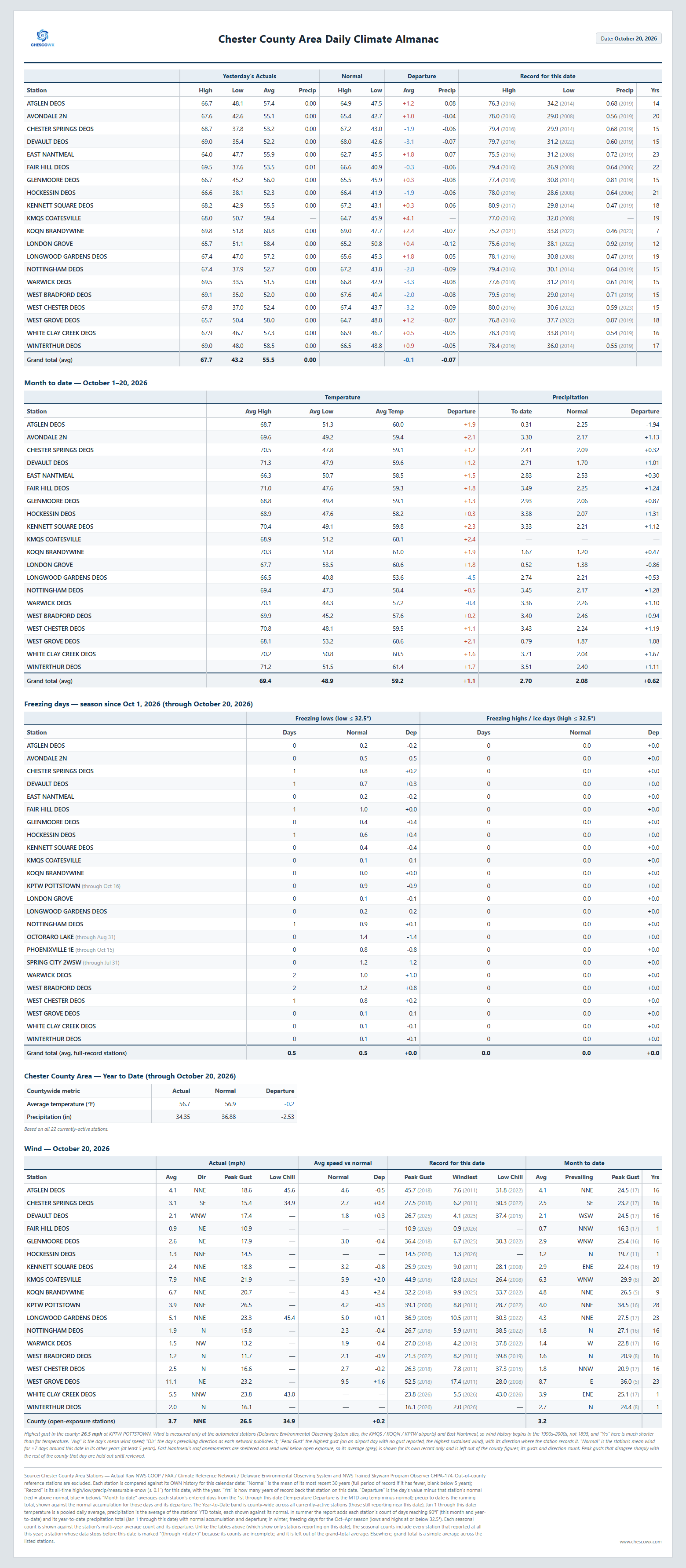
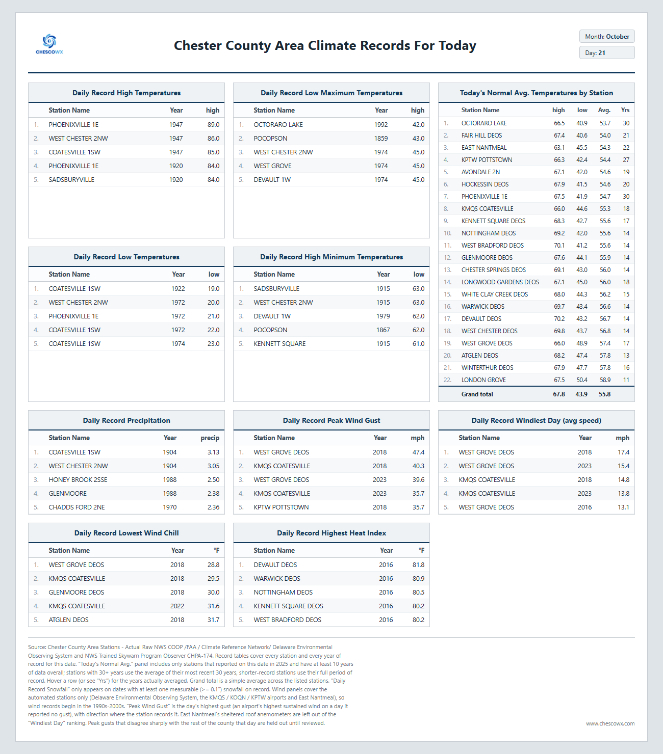
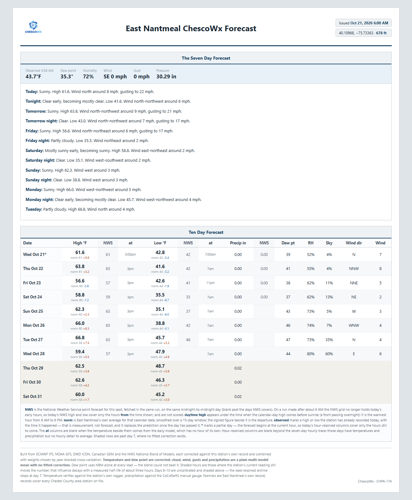
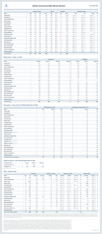
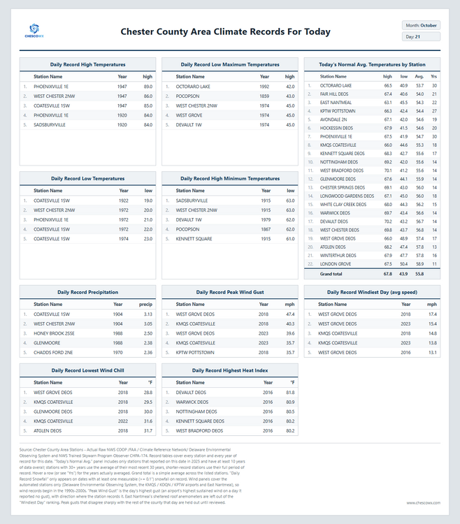
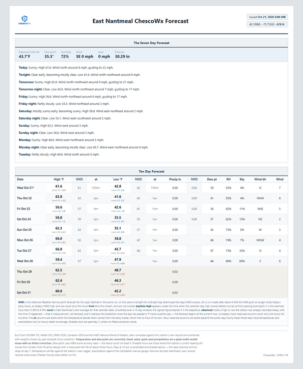
Today we should see highs from low 60's in ridge locations to the mid 60's in valley spots with lows tonight in the upper 30's to low 40's. It should be one of the better weather weeks of the year with almost no chance of rain. By Sunday morning we should see lows in the low to mid 30's with a freeze possible in the colder valleys! Temperatures will be near normal through Friday but this weekend we drop to about 5 degrees below normal, before we return to near normal by Monday. Of note 82 years ago today back in 1944 the Chester County Area was at the start of a 2 day storm that left as much as 1.63" of rain at Phoenixville 1E. This was the remnants of an unnamed hurricane which tracked within about 120 miles of the county.
-

E PA/NJ/DE Autumn 2026 Obs/Discussion
ChescoWx replied to PhiEaglesfan712's topic in Philadelphia Region
Today we should see highs from low 60's in ridge locations to the mid 60's in valley spots with lows tonight in the upper 30's to low 40's. It should be one of the better weather weeks of the year with almost no chance of rain. By Sunday morning we should see lows in the low to mid 30's with a freeze possible in the colder valleys! Temperatures will be near normal through Friday but this weekend we drop to about 5 degrees below normal, before we return to near normal by Monday. Of note 82 years ago today back in 1944 the Chester County Area was at the start of a 2 day storm that left as much as 1.63" of rain at Phoenixville 1E. This was the remnants of an unnamed hurricane which tracked within about 120 miles of the county.
-

2026-2027 Record-breaking El Nino
snowman19 replied to Stormchaserchuck1's topic in Weather Forecasting and Discussion
-
I feel like the robots are winning this. Another test is that big typhoon out in the west pac. Seems like bots are winning, but bots sort of moved towards the physical models with that.
-
.. there's historic data that suggests warm ENSO autumns frame cyclonic tendency in that region along and off the middle Atlantic. This year really hitting that with panache. There really wasn't much of an input in terms of arriving S/W mechanics into that region leading into that thing. There was only weak sauce arrival prior to the one at the end of September, either ... that made major media outlets millions on pimped out headlines... My hypothesis is that it is the CAG climo repositioning up and off the eastern seaboard - 'CAG' referring to the Caribbean Gyre... It's a general region of cyclonic tendencies that formulates in late summers and throughout autumns, situated as the naming suggests... around the Caribbean - although it's really typically over the western limb of that geographical region. Anyway, this is a source of 'home grown' TCs in the October climatology for west Atlantic Basin activity. Fronts or frontal echoes decaying through the Gulf can also formulate 'book end' spins but ... overlapping general vorticity potential in the area is an overall cultural jelly. The CAG is there because of overall large scale Coriolis balancing underneath autumn high pressure settling through the TX. My hunch is that the large hemispheric circulation mode/manifold favors this more off the EC than down there in typology. We have a high pressure seemingly eternally lodged and incapable of settling S of us - see current sfc analysis' - which has been there for days. When it breaks down... no worries. Another dying cool boundary wafts silently trough, and reinvigorates the high pressure all over again... and this is causing a standard weakness over/off the M/A just like the CAG machinery. interesting...
-
It won’t be your standard super Nino though…lots more in play…there will be surprises.
-
But the takeaway, are the bots getting it right more often? Or no?
-
Screaming PAC jet. Nino here
-
Maybe we are moving in the direction of making some small improvements on that front if the claims about this new AI corrected version of the EPS weeklies turn out to be correct.
-
But since I’m a man that’s honest, euro AI failed with the rain over us too back a few days ago.
-
 buy authentic synthroid tablets Levo Care Pharma purchase generic synthroid online
-
Man euro AI just wiped its ass with the euro op this weekend. Euro op had this cold shot coming in while euro AI laughed at it. Robots won.
-
I mentioned in the enso thread on the main forum, but honestly, pretty much everyone in the north and east is expecting a subpar winter relative to their climo. So the expectations are set. However, there are a few trolls in that thread that say absolutely ridiculous things that are completely unrealistic wrt weather, and these things will be hilarious when people bump them in the spring. People need to kinda chill on these insane assumptions because its such a strong Nino, especially with some things not behaving as expected. Do I expect a milder and less snowy than avg winter? Yes. But thats as far as ill go.
-
Frost again on elevated surfaces. 4 nights in a row.
-
Webber cancelling baby. https://x.com/webberweather/status/2112886732030886077?s=46
-
Not a big ran of Pivotal Weather website redesign.