All Activity
- Past hour
-
It is so hot! 87/77 with no wind making just a 15-minute dog walk a sweaty one. That Canadian airmass can't get here quick enough
-

July 2025 Obs/Disco ... possible historic month for heat
SJonesWX replied to Typhoon Tip's topic in New England
we dry. <2" since mid-June -
This summer pattern is a continuation of warmer along the coasts and cooler in the middle which has dominated since 2018. So it’s no surprise that the record heat has been focused in the East and West. It’s actually a reverse of the famous Dust Bowl pattern which had the warmth focused in the middle of the CONUS. This is why the places from the Upper Midwest to Great Lakes haven’t seen a repeat of the the record heat they got back in 1936, 1988, and 1995.

-

July 2025 Discussion-OBS - seasonable summer variability
LoboLeader1 replied to wdrag's topic in New York City Metro
90/66, topped out at 99 yesterday. -

July 2025 Obs/Disco ... possible historic month for heat
CoastalWx replied to Typhoon Tip's topic in New England
Stein was very evident in NH, especially srn NH when I was up there last week. 93 in srn NH looked like dead prairie grass. -

July 2025 Discussion-OBS - seasonable summer variability
Stormlover74 replied to wdrag's topic in New York City Metro
3knam too although a little further south -

July 2025 Discussion-OBS - seasonable summer variability
gravitylover replied to wdrag's topic in New York City Metro
If you needed to drive from here to Jamestown NY overnight and then loop around western NY tomorrow but could postpone it until next week, would you? I'm not liking the thought of driving in and out of torrential downpours on Rt17 for hours on end. -

July 2025 Obs/Disco ... possible historic month for heat
tamarack replied to Typhoon Tip's topic in New England
Low end normal - Sandy River flow has dropped below the 25th percentile (and 0.3% of the flood flow in Dec 2023). The small trib running thru our woodlot is down to wet sand, not even disconnected puddles. -

July 2025 Obs/Disco ... possible historic month for heat
dendrite replied to Typhoon Tip's topic in New England
Let’s get Islip a foot. -

July 2025 Obs/Disco ... possible historic month for heat
Brian5671 replied to Typhoon Tip's topic in New England
-
July 2025 Obs/Disco ... possible historic month for heat
CoastalWx replied to Typhoon Tip's topic in New England
Kind of looking like one of those NJ to NYC potential flash flooder. -
July 2025 Discussion-OBS - seasonable summer variability
Brian5671 replied to wdrag's topic in New York City Metro
NAM going wild over PHL to Western NJ with big rains 4-6 inches -

July 2025 Obs/Disco ... possible historic month for heat
weatherwiz replied to Typhoon Tip's topic in New England
Actually some good llvl dynamic cooling on the NAM -
I suspect that its urban heat island grew since the 1960s-1970s.
-

July 2025 Obs/Disco ... possible historic month for heat
dryslot replied to Typhoon Tip's topic in New England
On the northern edge of the precip up here, Meh. -

July 2025 Discussion-OBS - seasonable summer variability
TWCCraig replied to wdrag's topic in New York City Metro
91/68 HI 95 Hot, but dews aren't atrocious today -
 average temps start decreasing in august.
 -

July 2025 Obs/Disco ... possible historic month for heat
jbenedet replied to Typhoon Tip's topic in New England
I should complain more. Nice bump north on the 6z euro and 12z NAM. We take. -
July 2025 Obs/Disco ... possible historic month for heat
weatherwiz replied to Typhoon Tip's topic in New England
Nice good soaking. Could be a solid damaging wind event across Maryland and Delaware tomorrow. -
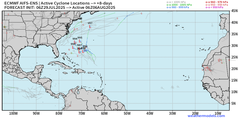
Well, appears the AI models need some more teaching and learning before they can predict tropical storm and hurricane formations. Andy Hazelton @AndyHazelton 1h Central Atlantic waves are pretty convection-free at the moment, as background stability and dry air suppresses rising motion. Not surprisingly, there isn't much model signal for development anymore - the AI models seemed to have been overzealous. For now it seems like physics-based models (e.g. GFS, Euro, and their ensembles) are still our best bet for sniffing out potential TC formation.
.thumb.png.2c30e7e960ed14b6503819a777f1e9e0.png)
-
July 2025 Obs/Disco ... possible historic month for heat
CoastalWx replied to Typhoon Tip's topic in New England
Good widespread rain anyways for many. -
July 2025 Obs/Disco ... possible historic month for heat
dryslot replied to Typhoon Tip's topic in New England
Did i miss the hourly temp maps this morning? -
Today should be our last 90-degree day for at least the next 10 or so days. We will see rain chances ramping up tomorrow afternoon into the evening with a cold front. We could see at least an inch of rain in many spots across the area with showers lasting until Friday. On Friday night we see some autumn like weather arrive for the weekend. Highs mostly in the 70's with lows in the 50's. Below normal temperatures look to continue through much of next week.

-
We've had only 2 heat waves in our 27+ years here, and 8/13-15 is one (other is 6/25-27/03). August 2002 had an 8-day run, 11-18, that had an average high of 89 with each day at 87-91. Wasn't too humid as the lows averaged 58, but our car's AC had conked out (at 204k miles) earlier that month. Then 9/9-10/02 reached 93/92. Since then, we've reached 90 eleven times but none later than June 28 - 2 in May and 9 in June. Odd distribution; maybe the taller dews and busier trees of mid-late summer have held down the max temps.
-

2025-2026 ENSO
donsutherland1 replied to 40/70 Benchmark's topic in Weather Forecasting and Discussion
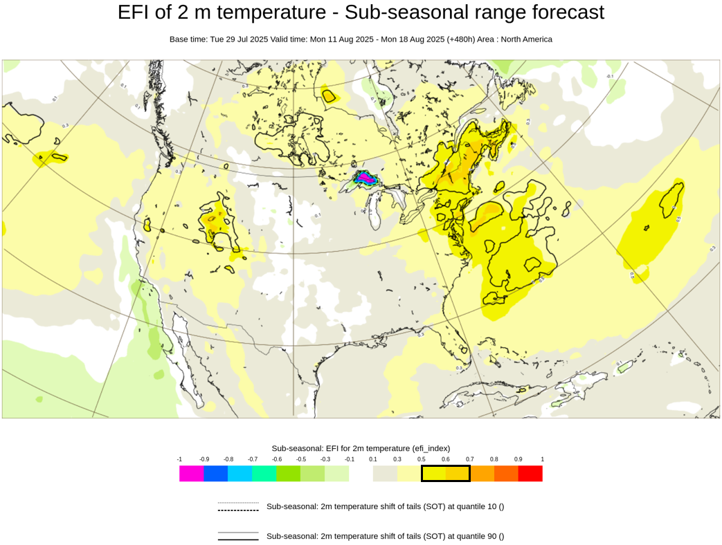
There's a pretty prominent heat signal showing up for parts of the East during the week of August 11-18:


.png.399afdb7bd6f66ddea4afb5be98f80eb.png)