All Activity
- Past hour
-
That deep-winter, tundra feel to it. Perfection!
-
I'm familiar with the map showing snow reports, thanks, but I'm looking for the contour maps they put out after events.
-
Definitely feels like winter tonight
-
Same here 9.6” ytd
-
18.3
-
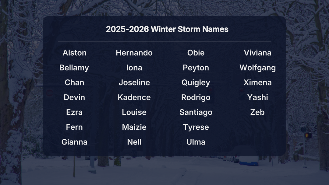
Winter storm Yashi
-
I personally am not that offended by Central Park's measurement. Could it have been half an inch more? Probably. But not this massive discrepancy. Had 3.0" in Mott Haven. There was noticeably more snow once you got into western Queens and NW Brooklyn. Between 4-5".
-
18.7
- Today
-
weather.gov/source/crh/snowmap.html?zoom=8&lat=41.64&lon=-71.61&hr=24 You can zoom or move the map to NYC's area.
-
Any snowfall maps out yet for NWS-Philly/NYC offices?
-
.thumb.png.4150b06c63a21f61052e47a612bf1818.png)
December 14th - Snow showers or Plowable snow?
HIPPYVALLEY replied to Sey-Mour Snow's topic in New England
That sounds fantastic and fun to witness! -
Nope they still do

-
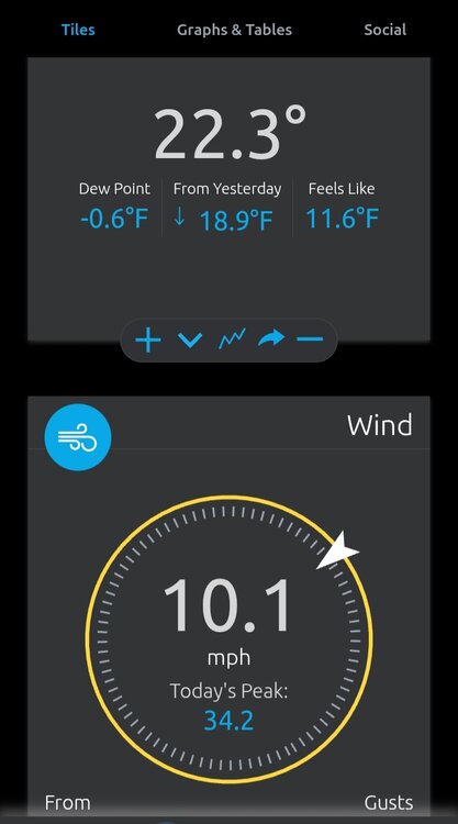
24 and the wind has really picked up. 20 to 30 mph range easily. Dew point at 6.
-
December 2025 regional war/obs/disco thread
HIPPYVALLEY replied to Torch Tiger's topic in New England
But you know it will just ride out as months of purgatory, so we may as well hope, the pattern tends towards snowy outcomes for New England. -
Side note I don’t think the weather channel keeps up with all the winter storm naming anymore. Their long standing criteria is to name a winter storm if there are 2 million people under winter storm warnings. They did that a few times earlier this month but there’s been a few more since then and they didn’t name it. There were a few times last year that they did this too because I noticed that I there were winter storm warnings over a large population a few times without a winter storm name. They were very consistent between late 2012 (when they started) and throuhh 2024 but they seem to only name some of them since last year. This past one had winter storm warnings from Illinois through Philly/NJ for like 10 million people but no name. Most of the time the names are pretty stupid but I do think it’s a plus when you have a large storm, easier to track it that way imo.
-
Right under the center of the high, it looks like. Assuming it stays above -14 before midnight, Champaign had a 1/-14 high/low today, which is a -36.5F departure from the 1991-2020 normal of 37/23. The -14 low is the coldest temp on record for so early in the season, and records go back more than 130 years. Until today, there were only 2 days in history with a -10 or colder temp on or before December 14th: 12/10/1917: -10 12/11/1917: -12 https://stateclimatologist.web.illinois.edu/wp-content/uploads/2025/12/weather-almanac-2025_Dec.pdf
-
20 in Fuquay-Varina...dewpoint -1. Still not impressive with a forecast high in the upper 30s tomorrow. Nothing to really see here!
-
-0.6 in Pikeville right now.
-
Score one for the optimists.
-

December 2025 Short/Medium Range Forecast Thread
Matthew70 replied to John1122's topic in Tennessee Valley
This is a brutal air mass. Will be interesting if January has some that will be worse than this. I saw reports of lake effect snows in NC. That’s insane for this time of year. -
The snow caught in the 4" COCORAHS gage melted to 0.71". I haven't done a core sample yet, but this one time the gage may be close to the actual SWE because there wasn't even a breeze during most of the storm. It did get windy with some blowing snow towards the end. Definitely over performed on total liquid and snowfall. 7.6", which brings our season total snowfall up to 7.6".
-

E PA/NJ/DE Winter 2025-26 Obs/Discussion
Birds~69 replied to LVblizzard's topic in Philadelphia Region
Tonight's predicted low is 16F. Already 16F at 10:55pm...snowpack factor. -

December 2025 regional war/obs/disco thread
WinterWolf replied to Torch Tiger's topic in New England
Love it…Great name…. -

December 2025 regional war/obs/disco thread
Snowcrazed71 replied to Torch Tiger's topic in New England
Lol... Don't bother waisting your breath on trash tiger. -
Lfg