All Activity
- Past hour
-
Bastardi is mad that this isn’t being highlighted in the NHC TWOs so far. Remember the recent no name system that hit SE NC with extreme flooding along with TS force su trained winds? JB is still mad about that and I don’t blame him.
-
The thing is that the season started with significantly warmer subtropical than tropical SSTs in the absolute sense, an uncommon setup. That’s evidently added to unusual tropical stability. After that, we added an unusual E US mean upper trough since August, which itself may be a separate factor negative for development. However, neither of those will likely carry over to W Caribbean season as a negative for future development. Plus we have Invest 92L now, which prior to 12Z runs had strong support for TCG.
-

September 2025 OBS-Discussion centered NYC subforum
FPizz replied to wdrag's topic in New York City Metro
12z Ukie pretty wet -

September 2025 OBS-Discussion centered NYC subforum
Brian5671 replied to wdrag's topic in New York City Metro
some of the 12z runs have a bit of an inverted trough feature over the region... -

September 2025 OBS-Discussion centered NYC subforum
Sundog replied to wdrag's topic in New York City Metro
This is the wettest Euro run yet for the coastal low. This is 6z: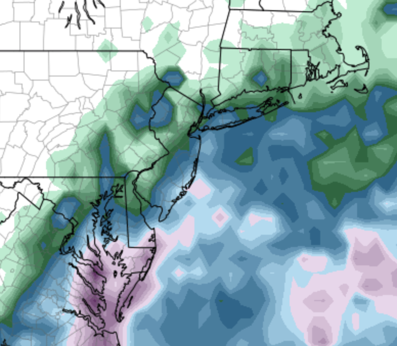
-
Highly recommend the movie Listers on YouTube. It’s about birdwatching, but it’s hilarious.
-
I suppose it wouldn’t be impossible for this to be designated a TD or even a TS. Bastardi is mad that the NHC hasn’t highlighted this yet.
-
After the sprinkle fest coming up, it looks like another beautiful stretch on tap.
-

September 2025 OBS-Discussion centered NYC subforum
Big Jims Videos replied to wdrag's topic in New York City Metro
Ocean temp is still in the low 70s at the beaches. Had quite a few rescues yesterday in this area -

September 2025 OBS-Discussion centered NYC subforum
psv88 replied to wdrag's topic in New York City Metro
82. Summer hanging on? -
Surprised the system right off NC isn't showing up on anyone's radar. It seems to be quite close to tropical storm level, with winds about 55 kph.
-
Inland for the big + departures
-
And it looks to screw the NW crew for the most part (possibly entirely). We could all use some rain drops.
-
Ravens beat the spread again. They are 2-0 vs the line this season. These are the same betting odds that currently has them tied for #1 super bowl favorite.
-
Just drove from Nags Head back through currituck. It's terrible. It was pouring on the beach. Then not so much through southern Currituck until north of Grandy and downhill again. Very gusty. Nasty. Feels damp but non tropical.
-
Please just hold the heavy/steady stuff off until AFTER 12:00 pm tomorrow in western Montgomery County.
-

2025 Atlantic Hurricane Season
WxWatcher007 replied to BarryStantonGBP's topic in Tropical Headquarters
Not tropical but plenty of impacts -

Fall 2025 Medium/Long Range Discussion
A-L-E-K replied to Chicago Storm's topic in Lakes/Ohio Valley
not seeing any end to the mild weather anytime soon - Today
-
And spread out over 24-48 hours. Not much consistency on when it’s raining for the metro areas.
-
This is an interesting take regarding AMO activity. The conclusion makes sense when you connect volcanic events during the inactive period timeframes. https://www.science.org/doi/10.1126/science.abc5810 Multidecadal climate oscillations during the past millennium driven by volcanic forcing
-
If we do in fact end up below 100 ACE, I think we need to seriously reconsider the 3 main factors the majority of people use for tropical seasonal forecasts…..ENSO state, MDR SSTs and the overall AMO state
-
Above average temps will couple with it. Nina is almost always warm/wet cold/dry.
-

September 2025 OBS-Discussion centered NYC subforum
anthonymm replied to wdrag's topic in New York City Metro
That pacific look is awful actually for the eastern US. The strongest warm anomalies are in the western pac. I think this is gonna reinforce western Aleutian ridging and troughing over the rockies. Should be a very familiar feeling winter for the I95, similar to the last few years with western storm tracks/great lakes cutters. -
Now that we're in CAM range, what really stands out to me is that this is going to me much more of a showery event than the rain shield I was expecting.
-
Congrats on the red tag!