All Activity
- Past hour
-
 Haven’t our historical hurricanes been during slow and below average years? I need something to grab onto because the Atlantic is as barren as a 60 year old British midwife right now.
 -
 I may be wrong but I think you are thinking of "How The World Ends"...
 -
 And 90 seconds later it is done.
 -
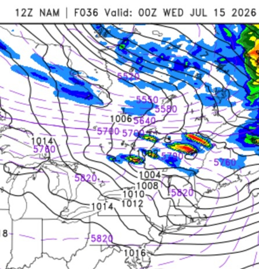
 I like what I see. Typically, set ups this potent in New England only occur every 10-15 years or so, going by our most sig tor events/outbreaks. This qualifies as one IMHO, and it has been 15 years since 6/1/11. Large-scale, this is not simply NW flow ring of fire event like we had on 7/1. There is a very strong 500 low over central Quebec w/ a center that gets as low as 543 dm, which is quite impressive for July. This is *true* NW flow, the best kind for the big svr here. EML solid up to 8 C/km. Timing looks absolute best for srn Quebec, but NNE should do very well. Noted CAPE fcst as high as 4100 on HRRR near YUL Tue aftn and 0-6km shear is more than enough for mean supercells. It is not as high as it was on 7/1, but we were severely lacking in CAPE and there was no EML, so things are more than compensated here for meaty storms and "Scott spinners." A few things of note that remind me of 7/10/1989. 1) Very strong WAA prior to the event, Look at the 12z NAM 1000-500 thk 14/12z to 15/00z for BOS, it jumps from 574 to 584! 2) I attached the 12z NAM valid 15/00z. Look at the orientation of the very high thk, a W-E axis. This is exactly how it looked on 7/10/1989, except the axis was about 100 mi farther S. For that event, it was capped from just S of NYC and S. So where SPC has the sharp cut off of storms in central New England makes sense 100%. If I had to find a negative, the 925 mb winds and 0-1 km shear could be higher, at least during the daylight hours, but by 00z, it is more than enough low-level shear for spinners. However, diurnal stabilization of the BL may limit solid spinners potential in New England. But the 18z HRRR is still showing small areas over 200 0-3 km CAPE 00/01z across far NNE, which is more than enough for solid low-level stretching and thus spinners. Historically, it is very rare for New England to get sig tor after dark. One thing that is almost certain, unreal LTG shows coming for ME/NH/VT Tue evening/overnight. better than event 7/1. EMLs "like" to do that!. The fact SPC has a hatched area for tor is not that common in New England, *and* wind/hail are also hatched for the full gamut of a big svr event! Updraft helicity swaths are nasty on the HRRR, again, rare to be this intense here. SCP and SIGTOR parameters are about as high as you will ever see them in the NEUS. Interesting the storms at first look more linear during the day on the HRRR, but become somewhat more discrete by sunset. This is likely due to the improving shear profiles at low-levels, so tor risk appears good at this later time. Really not much more to say. Slicing and dicing the models down at this point is not that much use. This is a high-end set up. Everything is there for a big event. Intense tstms are a virtual guarantee, just the question is the extent of the spinners overall in srn Quebec and NNE.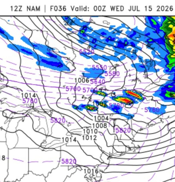
-
It’s actually raining a bit…
-

E PA/NJ/DE Summer 2026 Obs/Discussion
Birds~69 replied to PhiEaglesfan712's topic in Philadelphia Region
87F/DP 62F at 4:25pm AccuWeather going 101F on Wednesday...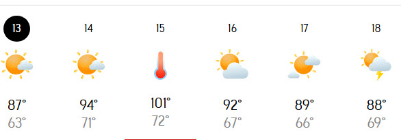
-
 There is this brief series done by the History Channel called "Doomsday". 10 episodes, each about a different way we could go extinct. One of the 10 was based on the Carrington event. I actually love the series, purely for entertainment. Its well done in terms of entertainment and "fear" factor. Every now and then I'll fall asleep listening to the series and sometimes I actually dream that I am immersed in whatever the scenario is The 10 are: Hyper volcano eruption (or something along those lines) Gamma Ray burst Earth ends up out of orbit and is swallowed by the sun Black hole swallows the moon and Earth Aliens solar storm Nuclear war Asteroid Earth hit by a rogue planet can't remember the last one
 -
Picked up .4 from a small but heavy shower moving east to west. Lots of loud thunder and cloud to ground lightning in it.
-
 Both great examples of how the current internet/Twitter/X/Youtube hype focuses on the worst case scenarios and is ultimately a detriment to any real cause. Who gives a crap about CC when a Carrington event or super caldera eruption is in the cards? Certainly not Joe Sixpack who's toiling away at some menial job to keep the lights on and maybe bring the family to McDonald's on the weekend.
 -
 Afternoon AFD from GYX. Tomorrow evening might get interesting. Our place is on/near the boundary between levels 2/5 and 3/5. I can't recall ever being in a 3/5 area. Now to the increasing threat for severe weather, which again could be potentially significant. An Enhanced Risk (Level 3/5) of Severe Weather is in place for northern NH and the western ME mountains,a Slight Risk (Level 2/5) for central NH and the Maine interior, and a Marginal Risk (Level 1/5) for coastal ME and approaching southern NH. A potent 500mb shortwave will cross Quebec in the afternoon and evening, with its associated cold front approaching the International Border from the northwest early Tuesday evening. Increasing forced ascent, significant height falls, and strengthening wind fields aloft will set the stage for severe thunderstorms to develop with the hot and humid air mass in place, further enhanced by an elevated mixed layer that will steepen lapse rates aloft. Today`s 12Z model suite, including CAMs, continue to show deep layer shear of 50-60 kt, MUCAPE in the 2000-2500 J/kg range, and high values of DCAPE (800-1000 J/kg) brought on by some dry air/high dewpoint depressions in the low levels. This supports damaging wind gusts, and given the parameters, there`s certainly potential for these to be significant on the order of 75+ mph. In addition, the instability profiles and steep mid-level lapse rates on forecast soundings depict large hail could be to the size of golf balls or even larger. There is also enough directional shear to support a tornado threat with mean 0-1km SRH of 100-200 m^2/s^2. These hazards are all possible within discrete or semi-discrete storm mode, but the primary hazard will become damaging winds when the dominant mode becomes more linear, although a tornado within the line(s) will remain possible. For timing: there`s strong consensus among the CAMs with multiple clusters or semi-discrete developing across southern Quebec in the late afternoon to early evening with rapid upscale growth in coverage and intensity as storms approach northern NH and northwestern ME in the 6pm to 8pm time frame. Storms are expected to quickly progress to the south the rest of the evening into the early overnight hours. However, it should be noted there are hints of isolated discrete cells developing in the 4pm to 6pm timeframe that may approach from the north. Based on CAM solutions, the threat for severe weather should diminish after 2 AM, but some development of showers and a few storms is possible overnight. This is not a yearly, typical threat of severe storms, and it becomes even more dangerous as the threat continues after dark. It is highly advised to have multiple ways to receive warnings, especially ones that will wake you up with the threat continuing into the late evening and early overnight hours. The highest risk areas also include many popular camping and recreation areas, which make those who are outdoors extremely vulnerable to falling trees.
 -

2026 Atlantic Hurricane Season
WxWatcher007 replied to Stormchaserchuck1's topic in Tropical Headquarters
GDM has nothing! Pretty sensitive setup it seems. -
I am writing from the Cincinnati area. The humidity of last week has diminished quite a bit, but I glanced at the radar and saw convective storms developing and sweeping westwards from West Virginia into the Moorehead, Kentucky area. The high pressure to the north must be tremendous to be getting moisture to move westward down there. It's interesting to watch and caught my eye. Here in the Ohio Valley, it looks clear though the entire week.
- Today
-
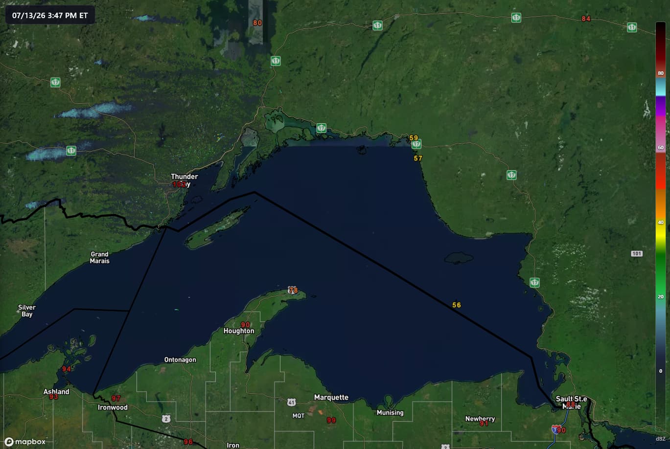
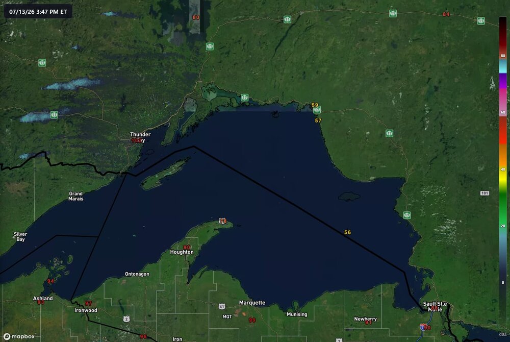
102 in thunder bay, 59 across the lake... nature's AC
-
Nothing to cope about. Just a lot of these cities have records going back at least 100 years, some into the 1800s. Just funny to see one that's only 1948. You can go back to being a Chicago lurker after your snipe attempt.
-
Or how about a Yosemite caldera eruption. That would be fun.
-
That would have been one hell of a day in the modern age
-
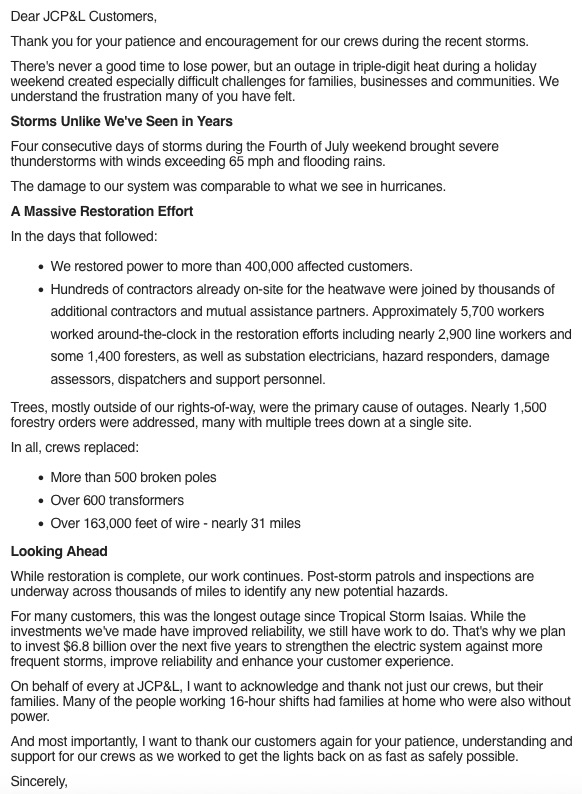
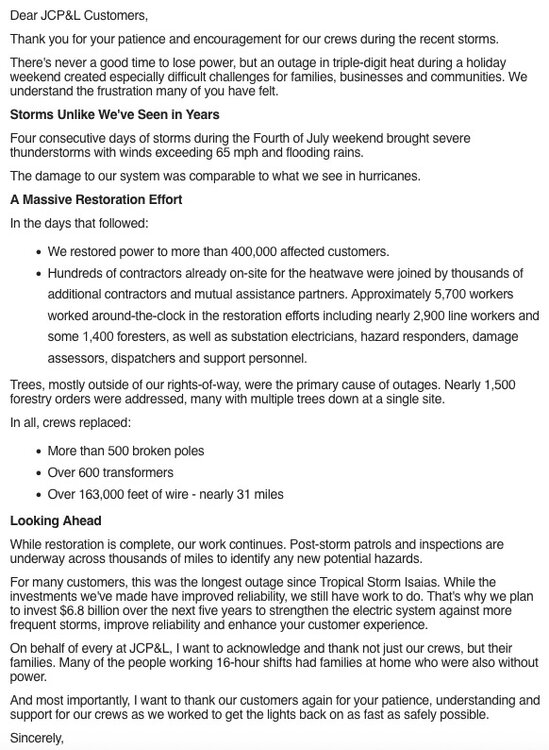
This is old news by now but there was quite a bit of damage with those holiday weekend storms. No wonder it took so long to get the power back. Next hurricane of substance that blows through the tri-state is going to be a big problem. Some people around my part of NJ were without power for a week. Something that affects the entire area with 60-80 mph winds is going to be a nightmare in terms of power outages. Not a matter of if but when.
-
https://hudsonvalleypost.com/new-york-could-see-strongest-winter-in-a-decade/?tsq=sl&fbclid=IwdGRjcATCHlFjbGNrBMIePmV4dG4DYWVtAjExAHNydGMGYXBwX2lkDDM1MDY4NTUzMTcyOAABHjp6J1TGE9ocHNhW8ZxgHKT91qC7PujWKSAcNuIu8S94zzo0OpS9RyHnJfyZ_aem_HlxhPu2lZX-qOcRhk70wDw
-

2026-2027 Super El Nino
MJO812 replied to Stormchaserchuck1's topic in Weather Forecasting and Discussion
https://hudsonvalleypost.com/new-york-could-see-strongest-winter-in-a-decade/?tsq=sl&fbclid=IwdGRjcATCHlFjbGNrBMIePmV4dG4DYWVtAjExAHNydGMGYXBwX2lkDDM1MDY4NTUzMTcyOAABHjp6J1TGE9ocHNhW8ZxgHKT91qC7PujWKSAcNuIu8S94zzo0OpS9RyHnJfyZ_aem_HlxhPu2lZX-qOcRhk70wDw -
 Imagine 96% of the world rendered dark interminably due to a Carrington redux event
 -

Mid-Long Range Discussion 2026
WinstonSalemArlington replied to BooneWX's topic in Southeastern States
-
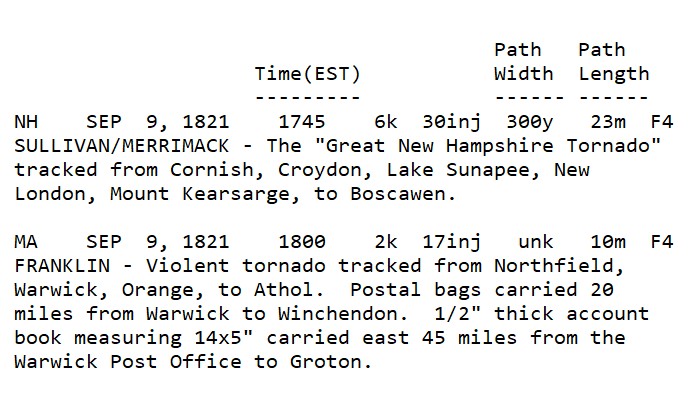
Summaries I made using data from The Tornado Project.
-
Yes, every location/region "pays the piper" eventually. Just it varies for each wx phenomena and climo! I don't think the general public understands this, and since some events are so uncommon and exceed regular memory or lifetimes, ppl freak easily. I get it, experience matters, but that's where knowing and understanding wx history comes in. I can not emphasize that enough! The point I was trying to drive home overall is that a min Cat 1 landfall, which is *not* extreme or unusual in the large pix for New England, will be treated as such b/c *impact* will be enormous. What I see all too often these days is that ppl conflate a wx event intensity w/ impact. They are not always directly correlated. Biggest SNE case I quote a lot is Dec 13, 2007 4-8" traffic nightmare. Run-of-the-mill storm well forecast, just timing was bad, and decisions made by officials/authorities made it epic bad from dismissing everyone from work/school noon-1pm when the S+ was underway. That scale of impact had almost nothing due to w/ the 4-8" of snow itself here. We handle 4-8" easily the vast majority of the time. So the hurricane massive and record power outages will largely be a function or increases population, infrastructure, mismanaged of land (tree trimming, etc), and things like power companies not prepared for the scale of impact (not enough staffing/equipment increase over time to handle the much larger population and infrastructure). And this will happen w/ a min Cat 1 hurricane almost certainly. Sure, you can blame the fact that we have gone record long w/o a landfalling hurricanes here, but the door swings both ways. Would it be better to have more landfalling hurricanes so we avoid the inexperience and complacency???
-
Still watching Gulf early next week:
-
Might add '38's drag race from the Outer Banks to LI, and a mid-September timing when the water temp is at/near peak.



.thumb.jpg.ad3a2e31d30aff035044689b311a0540.jpg)