All Activity
- Past hour
-

Septorcher 2026 Discussion - Endless Summer
dendrite replied to Damage In Tolland's topic in New England
I mowed the pawpaw and chestnut area once in the early spring and that has been it. There’s a little meadow back there now with clover, goldenrod, and aster. The crickets have been insane. -

Septorcher 2026 Discussion - Endless Summer
alex replied to Damage In Tolland's topic in New England
That’s why I like the pre-peak period. The contrast is much better than when it’s all orange and red in my opinion. Except for areas with lots of pines mixed in, obviously those always have good contrast. I imagine we’ll be past peak by next week but hopefully the colors last a bit -
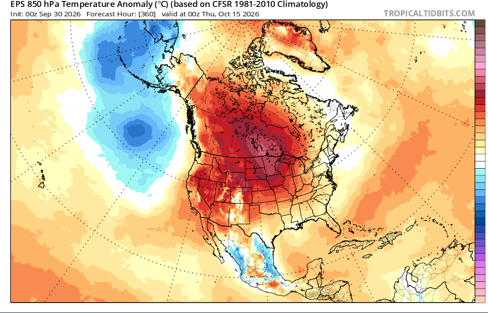
p big ridge signal in fantasy range on the eps
-
 DCA: +0.9 NYC: +0.8 BOS: +0.8 ORD: +1.1 ATL: +1.2 IAH: +1.4 DEN: +1.6 PHX: +1.5 SEA: +2.1
 -

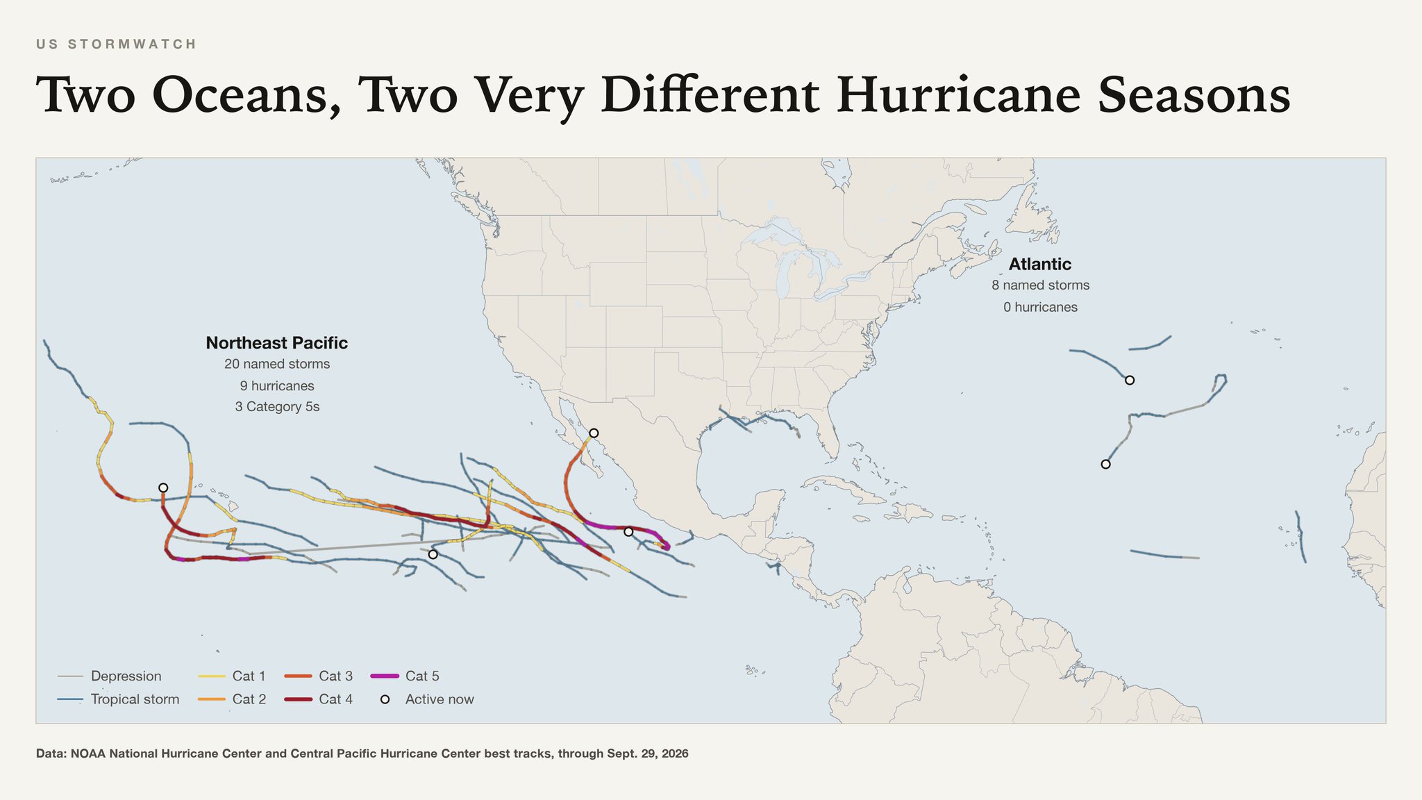
2026 Atlantic Hurricane Season
olafminesaw replied to Stormchaserchuck1's topic in Tropical Headquarters
-
We had an inch of snow on October 10, 1979. December was warm, but there were some okay snowfalls the rest of the winter. March 1 had eight inches and IAD's high was 17!!
-
Trying to get a mow in today and Friday morning before overseeding and areation. You think Friday morning looks good for a second lower cutting prior to areation? Going in to work at 2:00 PM today. Yeah and here is exactly what you mentioned.
-
 Tadalafil Tablet: TadaStream Rx - Buy Tadalafil 5mg
 -
Cheap generic Viagra online or Cheap generic Viagra online viagra canada https://maps.google.co.zm/url?q=https://sildendirect.com Cheap Sildenafil 100mg and https://gikar.it/user/iuiqvoudpt/ buy Viagra over the counter [url=https://clients1.google.com.vc/url?q=https://sildendirect.com]Order Viagra 50 mg online[/url] Viagra online price or [url=http://www.iawbs.com/home.php?mod=space&uid=988364]viagra without prescription[/url] order viagra
-

Septorcher 2026 Discussion - Endless Summer
Typhoon Tip replied to Damage In Tolland's topic in New England
some of the model cloud/RH products might have been a bit optimistic ... Hi res vis suggests we suffer lowering sun angle and now less able to thermally induce erosion, because there's really nothing above about 1,000 feet elevation but the moon so the sun must be like skipping off the pond so to speak... there's some sky lights just beginning to open. If this were May we'd be full sun. the sounding would shoot us to 82 already but this late in the year and time today getting eaten by cool saturation at 900 feet should limit us under potential - a seasonal feedback mechanism. -
Cheap generic Viagra online or Cheap generic Viagra online viagra canada https://maps.google.co.zm/url?q=https://sildendirect.com Cheap Sildenafil 100mg and https://gikar.it/user/iuiqvoudpt/ buy Viagra over the counter [url=https://clients1.google.com.vc/url?q=https://sildendirect.com]Order Viagra 50 mg online[/url] Viagra online price or [url=http://www.iawbs.com/home.php?mod=space&uid=988364]viagra without prescription[/url] order viagra
-

October Comes Early: Late September Multi-Hazard Hybrid Storm
CoastalWx replied to WxWatcher007's topic in New England
Looks like a cool stretch overall coming up starting this weekend for at least a week or so. -
…. and here I am planning Acadia Natl. Park for one of next 3 days (Oct 1, 2, 3). No big rain forecasts up here — I think.
-
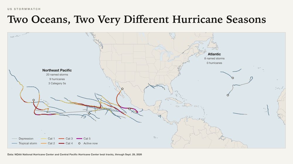
Yaakov, So, the Energizer Bunny may really come back for a 3rd time? Holy cow! Here’s the 0Z UKMET, which suggests that: 0Z UKMET actually has it as a non-TC tomorrow: GLOBAL MODEL DATA TIME 0000UTC 30.09.2026 TROPICAL DEPRESSION FAY ANALYSED POSITION : 23.4N 48.7W ATCF IDENTIFIER : AL062026 LEAD CENTRAL MAXIMUM WIND VERIFYING TIME TIME POSITION PRESSURE (MB) SPEED (KNOTS) -------------- ---- -------- ------------- ------------- 0000UTC 30.09.2026 0 23.4N 48.7W 1013 21 1200UTC 30.09.2026 12 23.3N 50.8W 1014 22 0000UTC 01.10.2026 24 CEASED TRACKING When I first saw this part of the 0Z textual output, I thought that even the UKMET had finally given up on it. But as I looked further down to look at other TCs, what did I see? Fay came back 36 hours later! NEW TROPICAL CYCLONE FORECAST TO DEVELOP AFTER 60 HOURS FORECAST POSITION AT T+ 60 : 25.4N 58.6W LEAD CENTRAL MAXIMUM WIND VERIFYING TIME TIME POSITION PRESSURE (MB) SPEED (KNOTS) -------------- ---- -------- ------------- ------------- 1200UTC 02.10.2026 60 25.4N 58.6W 1015 25 0000UTC 03.10.2026 72 26.8N 59.6W 1014 27 1200UTC 03.10.2026 84 28.3N 60.5W 1014 26 0000UTC 04.10.2026 96 30.3N 60.5W 1014 26 1200UTC 04.10.2026 108 32.2N 59.4W 1014 27 0000UTC 05.10.2026 120 33.6N 58.4W 1013 26 1200UTC 05.10.2026 132 34.6N 56.7W 1011 25 0000UTC 06.10.2026 144 35.4N 55.1W 1009 24 1200UTC 06.10.2026 156 CEASED TRACKING

-
https://tadastreamrx.shop/# Cialis 20mg price
-
 Yeah, October is the only month of the year that has an opposite correlation to DJFM NAO. I don't know if that's true given 250+ years of examples though.
 -
 October DCA _ NYC _ BOS _ ORD _ ATL _ IAH _ DEN _ PHX _ SEA 1.0 0.9 0.9 0.6 1.4 0.2 3.3 2.1 3.1
 -

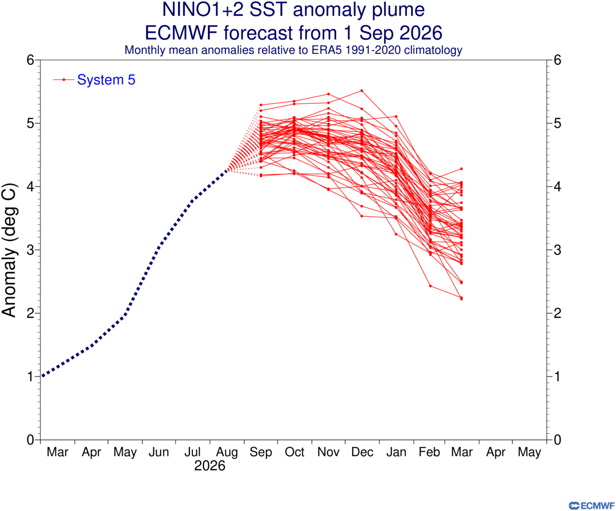
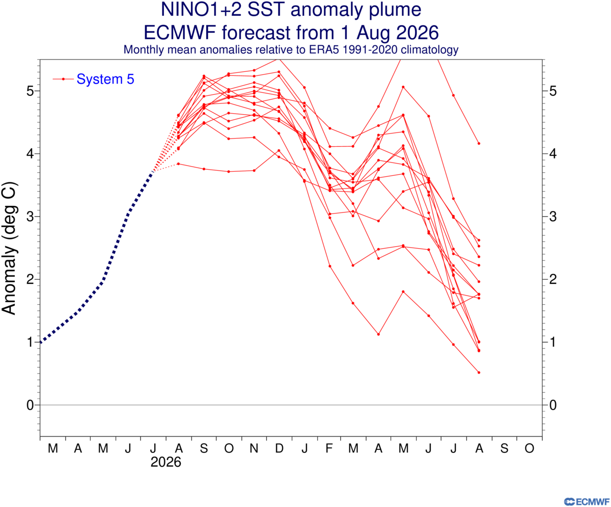
2026-2027 Record-breaking El Nino
bluewave replied to Stormchaserchuck1's topic in Weather Forecasting and Discussion
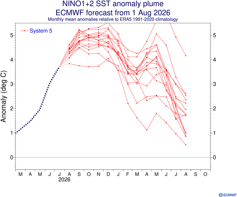
While the Euro is doing better with +1.2, it’s still too low also. Probably related to the models underestimating the strength of the WWBs in the longer range. The next Euro update on the 5th should be interesting when the warmer current conditions are incorporated into the new forecast. The EPS weeklies have been closer.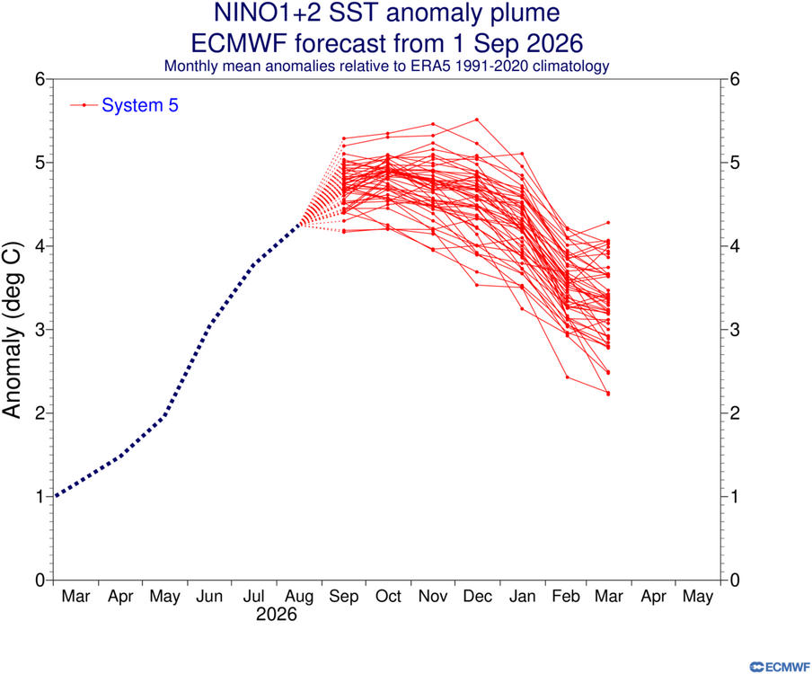
-
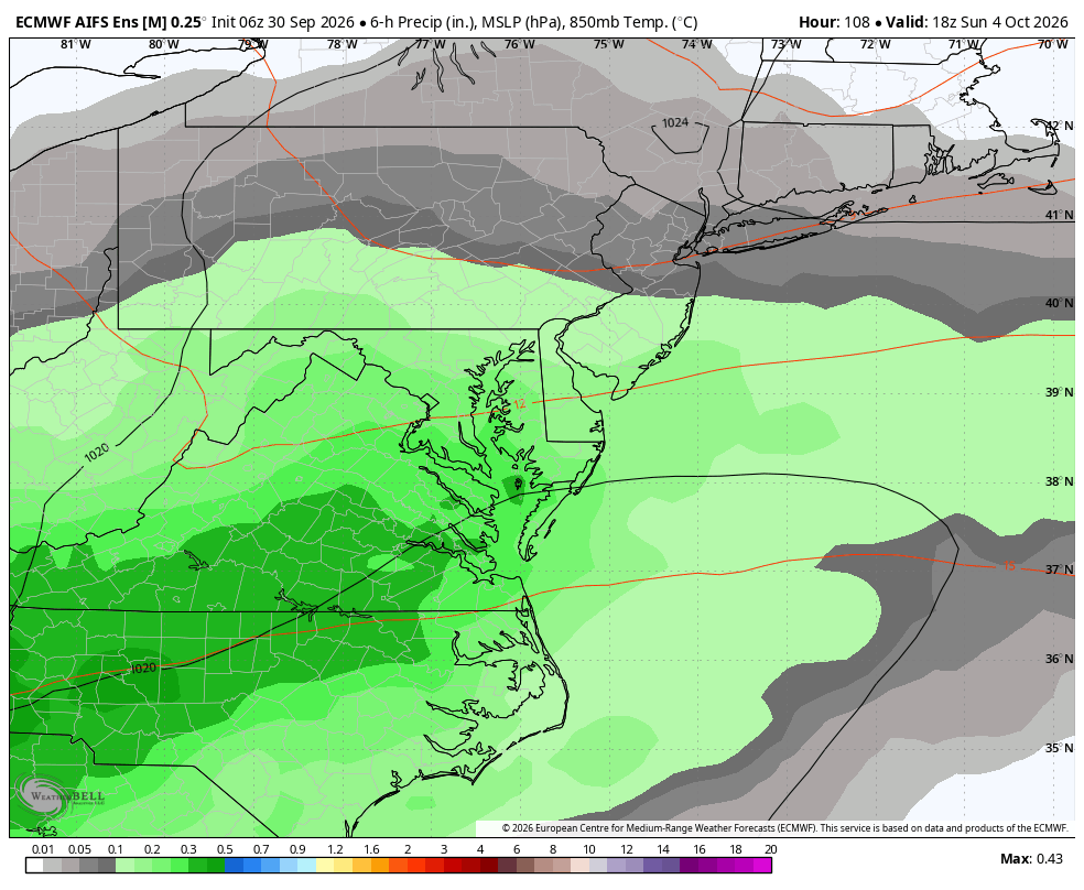
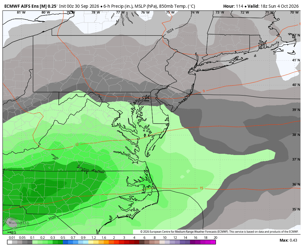
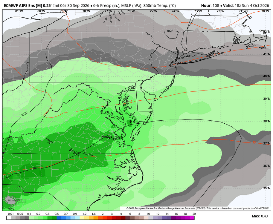
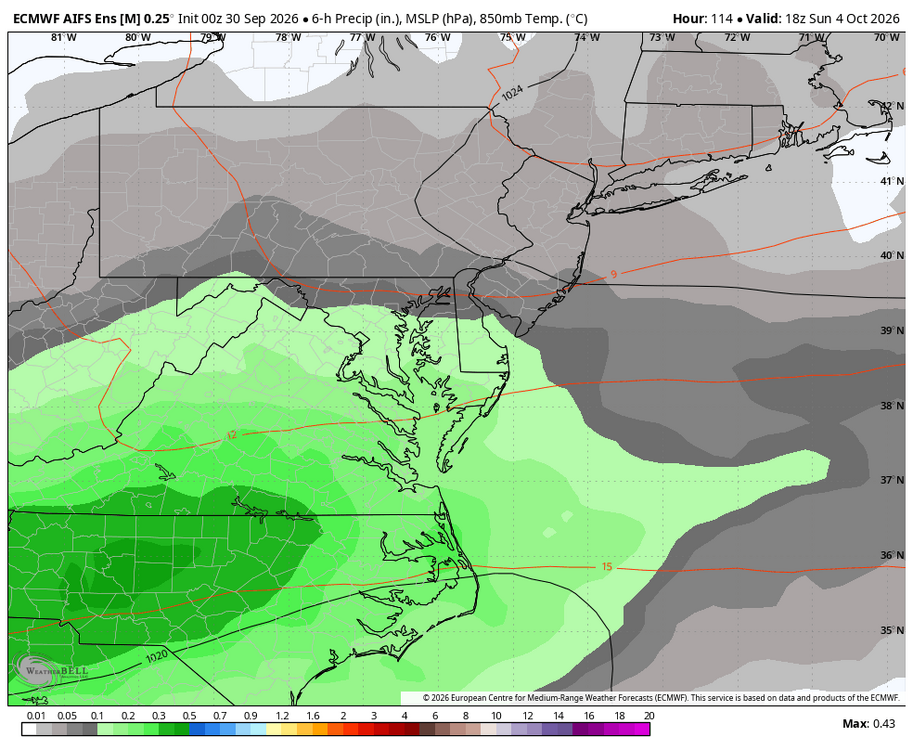
WB EURO AI 6Z ensemble compared to 0Z ensemble for Sunday.
-

Central PA Autumn 2026
TheDreamTraveler replied to canderson's topic in Upstate New York/Pennsylvania
I guess summer has one last hurrah on Thursday/Friday. Then after that we might have a night that gets into the 30's on Tuesday -
6z euro AI jumped back north for the weekend rain and it’s ensembles even more so.
-

2026-2027 Record-breaking El Nino
LakePaste25 replied to Stormchaserchuck1's topic in Weather Forecasting and Discussion
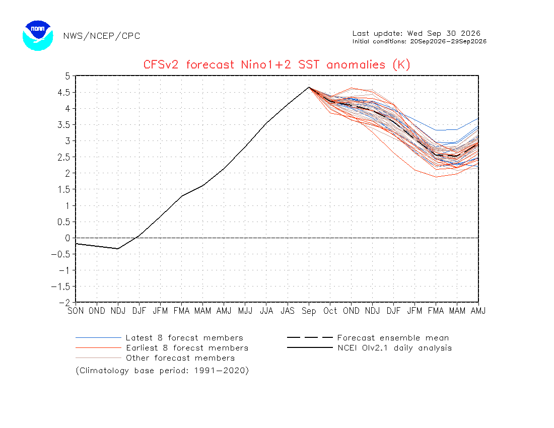
As expected, the CFSv2 is going to be way off with Nino 1+2, forecasting a drop that never came.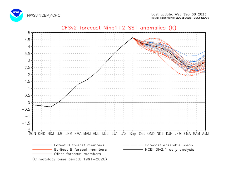
-
I chased that storm.. may have been my first ever. In the Mts just outside of Roanoke. Had 6+. then a burst of rain, another 4+, back to rain then another few inches. Top depth in the morning was 8 inches.
-
October Comes Early: Late September Multi-Hazard Hybrid Storm
CoastalWx replied to WxWatcher007's topic in New England
I think it helped, but I noticed in these events with coastal convergence it’s more or less adding sheet rain type stuff vs the borderline convective elements that came in from the SE. So imo It added to it, but I think it would only explain some of the difference. I noticed earlier in the event it was more evident. -
The season of cold fronts