All Activity
- Past hour
-

Richmond Metro/Hampton Roads Area Discussion
wasnow215 replied to RIC Airport's topic in Mid Atlantic
Not much juice on here about severe today. People need to really pay attention it could be pretty darn bad. -
I've realized that my true passion is snowstorms. I guess I'd also be interested in a tropical system or severe storms if they panned out, but these types of systems bore me, generally. Need something damaging like Oct 21 to peek my interest.
-
Not even a clap of thunder! We’re lucky it’s moving through in the morning though, it’s impressive how well it became organized when it hit higher dews east of the escarpment. It’s going to be a rough day for the piedmont.
-
Yeah looks like the PV consolidated
-
@bluewavewas referring to the New York City region. Yes, the March 2012 heatwave, June 2021 PNW heatwave, April 1976 one (no longer as anomalous today) are also benchmark heat events.
-
.thumb.jpg.6a4895b2a43f87359e4e7d04a6fa0d14.jpg)
Central PA Spring 2026 Discussion/Obs Thread
Yardstickgozinya replied to Voyager's topic in Upstate New York/Pennsylvania
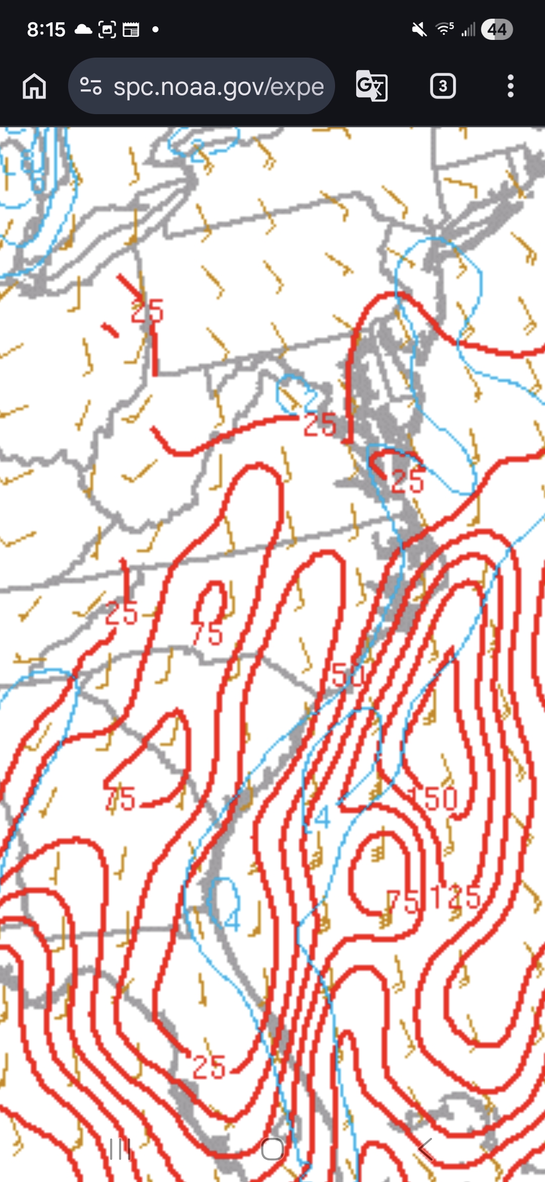
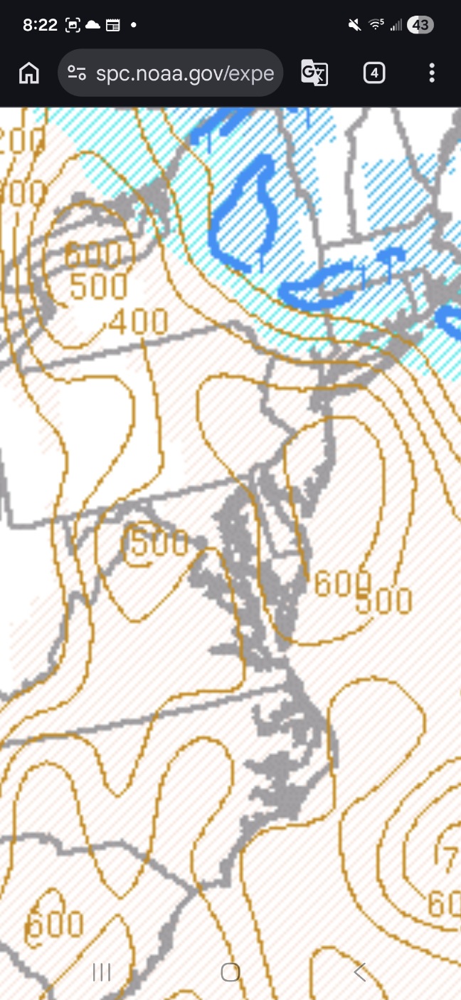
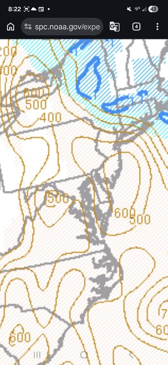
It's still early in the day, but meso scale data has been updated and at this juncture we are missing 2 of the most important parameters for tornadoes, surface cape and surface velocity (top graphic) are basically not existing at this point. There is a slight overlap in the chesapeake, but a surface cape of 25 and a surface velocity 2 is most likely not producing a tornado. There's also, some areas of extra overlaps around the Hagerstown area but nothing exceptional with this point. I'll be watching the surface all day as long as i'm not napping. We do have rising downdraft cape (bottom graphic) parameters so anyone who gets under convection or , even heavy rain might be in for a rough time. I'm sure no one needs any reminders, but I'm an idiot not a met., so make sure you're listening to your local met and not an idiot.
-
Yes I was living in Ashaway SwRI and was actually live on air with Jim Cantore while he was in studio. My total was 23 inches with 7 foot drifts.
-
 Day 1 Convective Outlook NWS Storm Prediction Center Norman OK 0732 AM CDT Mon Mar 16 2026 Valid 161300Z - 171200Z ...THERE IS A MODERATE RISK OF SEVERE THUNDERSTORMS TODAY ACROSS PARTS OF CENTRAL MARYLAND...MUCH OF CENTRAL AND EASTERN VIRGINIA...CENTRAL NORTH CAROLINA AND ADJACENT PORTIONS OF SOUTH CAROLINA...... ...SUMMARY... Fast moving thunderstorms may become widespread and accompanied by the risk for damaging wind gusts and a few tornadoes across the Mid Atlantic today. There is potential that a couple of storms could become capable of producing strong and long track tornadoes. ...Southeast States... An intense upper trough continues to deepen over the Mid MS Valley, with its associated surface cold front surging eastward across the Appalachians and into the Carolinas/Mid-Atlantic. An active line of thunderstorms is accompanying the front from GA into western SC/NC/VA. Low-level winds are very strong along and ahead of these storms, encouraging the risk of numerous severe wind gusts and embedded QLCS tornadoes along the line. Clusters of thunderstorms have been developing ahead of the line as well, in a moist and strongly sheared environment. These storms will also pose a severe/tornado risk through the day as the primary large-scale ascent arrives. ...Mid Atlantic States into NY... Farther north, low-level moisture is a little more limited and CAPE values will be slightly lower. Nevertheless, intense low and mid level wind fields will be present across this region as the cold front approaches from the west. Thunderstorms are expected to strengthen through the late morning across west-central VA into central NY/PA and spread eastward to the coast by early evening. Forecast soundings across this area show very large low-level shear values that will favor the risk of widespread damaging winds and several tornadoes. Strong tornadoes will be possible - especially from MD southward where the greatest low-level moisture will be present. In the wake of the main convection, secondary cyclogenesis is forecast to occur late this afternoon along the cold front over VA/MD. The initial storms will remove most of the low-level moisture/instability, but the extreme intensity of the low-level winds fields and large-scale forcing could result in a secondary risk of damaging winds from low-topped showers and thunderstorms after dark. This threat could spread northeastward into eastern PA/NJ and perhaps southern New England. ..Hart/Lyons.. 03/16/2026
- 313 replies
-
- 2
-

-

-
- severe
- thunderstorms
- (and 1 more)
-
No cold anywhere all the sudden (outside of Canada)
-
There are injuries, sadly sometimes deaths, and lots of property damage in all kinds of extreme weather. Including winter storms. Snowcrete had THOUSANDS of slip injuries enough to go to ER, just in RVA alone. Nobody "wants" any of that. So let's stop with the halo stuff and just talk about possible scenarios.
-
Severe Weather Statement National Weather Service Greenville-Spartanburg SC 829 AM EDT Mon Mar 16 2026 NCC045-SCC021-087-161300- /O.CON.KGSP.TO.W.0002.000000T0000Z-260316T1300Z/ Cleveland NC-Cherokee SC-Union SC- 829 AM EDT Mon Mar 16 2026 ...A TORNADO WARNING REMAINS IN EFFECT UNTIL 900 AM EDT FOR SOUTHWESTERN CLEVELAND...CHEROKEE AND NORTHWESTERN UNION COUNTIES... At 829 AM EDT, a severe thunderstorm capable of producing a tornado was located 8 miles north of Gaffney, or 4 miles southwest of Boiling Springs NC, moving east at 45 mph. HAZARD...Tornado. SOURCE...Radar indicated rotation. IMPACT...Flying debris will be dangerous to those caught without shelter. Mobile homes will be damaged or destroyed. Damage to roofs, windows, and vehicles will occur. Tree damage is likely. This dangerous storm will be near... Patterson Springs and Earl around 840 AM EDT. Other locations impacted by this tornadic thunderstorm include Cherokee Falls, Draytonville, Thicketty, Saratt, and Kings Creek.
-
Probably the hardest snow event I've ever attempted to measure. A lot of areas of the yard are completely scoured free of snow, with other areas buried 1-3ft with snow drifts. Still in heavy snow right now with this narrow band. Came up with an average of 6.3", but the real amount is likely higher than that. A lot of granulation going on at ground level with these steady 40+mph winds blowing in off of the farm fields. Definitely looks like a legit blizzard out there this morning.
-
Still a hold with everything on the 1300z SPC OTLK... 15 tor/5 hail/ 60 wind
- 313 replies
-
- 2
-
-
- severe
- thunderstorms
- (and 1 more)
-
 Snowstorms are deadly as well. Especially blizzards! Anyway it’s possible to be excited for interesting weather and hope everyone is safe at the same time. Otherwise might as well just move to San Diego.
- 313 replies
-
- 2
-

-
- severe
- thunderstorms
- (and 1 more)
-
I think mid-April 2002 and March 2012 is the best comparison. They came on the heels of warm and snowless winters, which is what we have in the West. February 2018, on the other hand, was just an outlier warm month, in what was otherwise a cold winter and early spring. If we go back to the 20th century, then the April 1976 is the most anomolous early heat wave ever in the Northeastern US. Providence recorded a 98-degree day in April, which not only smashed the April monthly record, but it was higher than any temperature recorded in May and (until last year's 100) June. [Providence breaking the June monthly high by 3 degrees last year is another amazing feat.] Temperatures never got that hot again in many places during the rest of the Bicentennial summer.
-
-
WWA for 4-6" here which was a surprise. Here's hoping to maybe one last hurrah before this season winds down.
-
Looking like near normal overall as we get into the last week of the month - back and forth warmer / cooler progression
-
First lightning here in the triad as this first line passes thru. Very heavy rain in bursts, gusty winds but nothing serious at all. So far a nothingburger. Hope it stays that way.
-
Midway Dep EWR: +5.2 NYC: +5.1 LGA: +3.9 JFK: +2.9
-
 I might have been misunderstood - but the firefighters I know yes, do not WISH for people's homes to catch fire - but on a dead quiet shift absolutely 100% get excited when a call comes in. I thought it was a good parallel because of course they are not hoping for somebody's livelihood to be destroyed or for lives to be lost...but if a fire were to break out - they want to be the ones responding. We have no control over the weather. Regardless - we can take the weather ethics debate to banter - I am 100% sure that zero people here are 'wishing' for people's homes to be destroyed is my point. But we are weather enthusiasts - we have NO CONTROL over it - we are going to track interesting weather with fascination and interest. It doesn't mean we are hoping for dead people.
- 313 replies
-
- 1
-
-
- severe
- thunderstorms
- (and 1 more)
-
Records: Highs: EWR: 82 (1990) NYC: 82 (1990) LGA: 77 (1990) JFK: 68 (2002) Lows: EWR: 17 (1992) NYC: 13 (1911) LGA: 19 (1992) JFK: 18 (1992) Historical: 1843: A great snowstorm affected areas from the Gulf of Mexico to Maine. Shelbyville, TN received 21 inches. Eight inches fell at Little Rock, AR. 10 inches fell at Memphis, TN and Washington, D.C. and a foot was reported at Baltimore, MD, New York City, NY and Philadelphia, PA. (Ref. Wilson Wx. History) 1870: 24 trains between Springfield, MA and Albany, NY were blocked by a big snowstorm. (Ref. Wilson Wx. History) 1885: On this date through the 21st, Pointe-des-Monts, Quebec Canada, received 98 inches of snowfall. 1942 - Two tornadoes, 24 minutes apart, struck Baldwin, MS, resulting in 65 deaths. (David Ludlum) 1942: A deadly tornado outbreak occurred over the Central and Southern US on March 16-17th. The tornado outbreak killed 153 people and injured at least 1,284. The best estimate indicates this event contained 13 F3 tornadoes, 6 F4s, and one F5. The F5 tornado occurred north of Peoria, Illinois, in the towns of Alta, Chillicothe, before crossing the Illinois River and striking the town of Lacon. A quarter of the homes in Lacon were destroyed, and debris was carried for 25 miles. 1975 - A single storm brought 119 inches of snow to Crater Lake, O,R establishing a state record. (The Weather Channel) 1986 - A small but rare tornado touched down perilously close to Disneyland in Anaheim CA. (Storm Data) 1987 - Softball size hail caused millions of dollars damage to automobiles at Del Rio TX. Three persons were injured when hailstones crashed through a shopping mall skylight. (The National Weather Summary) (Storm Data) (The Weather Channel) 1988 - A winter storm produced heavy snow in the Central Rockies. Winds gusted to 80 mph at Centerville UT. Eighteen cities in the southeastern U.S. reported new record low temperatures for the date, including Tallahassee FL with a reading of 24 degrees. (The National Weather Summary) 1989 - A winter storm brought heavy snow and high winds to the southwestern U.S. Winds gusted to 60 mph at Lovelock NV, Salt Lake City UT, and Fort Carson CO. Snow fell at a rate of three inches per hour in the Lake Tahoe area of Nevada. (The National Weather Summary) (Storm Data) 1990 - Thunderstorms developing ahead of a cold front produced large hail and damaging winds from northwest Florida to western South Carolina. Thunderstorm winds gusted to 75 mph at Floridatown FL. Sixteen cities across the northeastern quarter of the nation reported record high temperatures for the date. The afternoon high of 78 degrees at Burlington VT smashed their previous record for the date by 23 degrees. New York City reported a record high of 82 degrees. (The National Weather Summary) (Storm Data) 2002: Anchorage, Alaska on the 16th and 17th: Alaskan snowstorm dumps 28.7 inches of snow on Anchorage, breaking the old daily record of 15.6 inches. Snow amounts range from 24 to 29 inches at lower elevations (Ref. WxDoctor) 2005: A storm surge pushed 33 foot waves, rocks and tons of ice crashing along the Avalon and Baie Verte Peninsulas on the east coast of Newfoundland Canada, causing millions of dollars in damage. (Ref. Wilson Wx. History) 2012: Record heat continues in the Mid-West see the 17th for more information. • 82 degrees at Chicago-O'Hare was the earliest it has been this warm in Chicago. Previously... the earliest 82 degree reading was not until March 27, 1945. • Chicago set a new record for most number of 80 degree days in a March with three... the previous record for greatest number of 80 degree days during March was 2 set back in 1986. • March 16th was the 3rd consecutive day above 80...which shattered the previous record for earliest in the season to have 3 consecutive 80 degree days. Previously the earliest Chicago has ever seen 3 consecutive 80 degree days was back on April 14-16 1976. (Ref. NWS)
-
I hope its not bad already clear here in Charlotte so not sure if that would translate the same up there well before mid day.
-
Going to be lit up down that way today. That power outage map is going to look pretty wild I imagine
-
 Feels like the floor of today (assuming we get socked in with crapvection) still feels significant.
- 313 replies
-
- 2
-
-
- severe
- thunderstorms
- (and 1 more)