All Activity
- Past hour
-
Even 27 in Damascus is caving.
-
Are the folks that made weather decisions at mcps just complete incompetent morons? .
-
Eh. Took a closer look at the flakes and they’re little pixie dust things. Need more if there’s gonna be anything worthwhile here
-
-
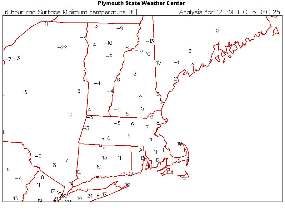
12z mins
-
Sun is up, car and deck are covered. Steady light snow.
-
Down to 4 at home in Westfield. A friend in Southwick currently at 2. I'm pissed I wasn't able to finish my re insulation project at home before winter hit, hopefully next heating season it'll be complete.
-
i measured 0.3" as of 7 am, so even though it may not seem like it, we're still on track as of now.
-

December 2025 regional war/obs/disco thread
mahk_webstah replied to Torch Tiger's topic in New England
Next week looks like could be mixed precip up here. Wasn’t expecting that. -
Did they close? Open? Some of us don't use twitter/X whatever and can't see what you are talking about. Glad Howard County is open. Every closing just adds days in June, which sucks for summer vacations. I'm enjoying looking at the light snow falling, sitting next to our wood stove enjoying breakfast!
-
8°
-

December 2025 regional war/obs/disco thread
Sey-Mour Snow replied to Torch Tiger's topic in New England
Sucks, at least we look to reload to a pattern with some chances after a brief cutter potential next weekend .. Eventually one of these shortwaves will have to hit for a 3-6" event for SNE.. -

2025-2026 ENSO
donsutherland1 replied to 40/70 Benchmark's topic in Weather Forecasting and Discussion
The EPS and GEFS are indicating that the WPO will spend much of the December 10-20 period at or below -2.000. Regardless of whether the EPO is positive, AO is positive, and PNA is negative, severely negative WPO patterns tend to overwhelm the impact of the other teleconnections. Such patterns typically feature colder than normal conditions in the eastern half of North America and warmer conditions in the western half. December 15-18, 2013 offers a representative case with the distribution of warm and cold anomalies: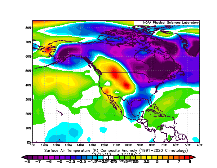
-

E PA/NJ/DE Winter 2025-26 Obs/Discussion
Birds~69 replied to LVblizzard's topic in Philadelphia Region
21F at 6:55àm -
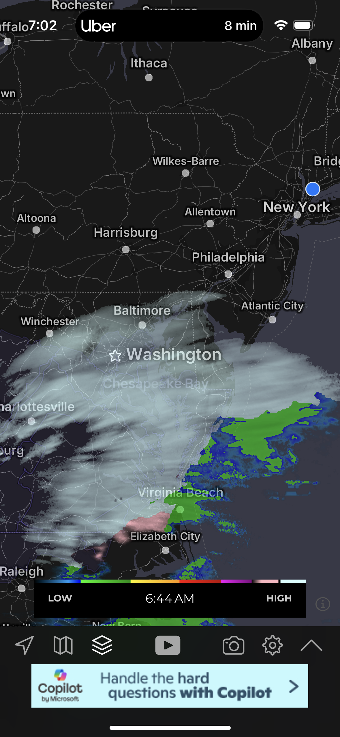
that band in fredricksburg looks to make its way to DC region very soon, probably around 8.
-

The Return of the 12/5 Snowstorm
NorthArlington101 replied to SnowenOutThere's topic in Mid Atlantic
DC looks kinda in the screw zone for the moment unless that band can make it north. Was a little worried about being between bands yesterday. Got my dusting so I’m mostly content but would like to squeeze out 0.5” -

December 2025 regional war/obs/disco thread
moneypitmike replied to Torch Tiger's topic in New England
Pit2 checks in with a 1.2. Close but no cigar. -
Clarksburg MD, SN 24/20 - Roads are completely covered.
-
You're getting an inch of snow.
-
Heads up early Saturday: NO thread at this time but there could be a frozen-freezing trace to 1/4" snow-sleet-freezing rain event along I95 tomorrow morning between roughly 2A-8A (rain Long Island). Not threading but multiple models trying for this including the late on board EC. It's minor but worthy of monitoring and I could see this eventually needing a short fuse SPS, or even an advisory. These are the unexpected travel issues, especially after an afternoon of temps barely above freezing.
-
16 hours ago so yes. I’m actually surprised they didn’t delay.
-
Aggressive dusting here accumulating on every surface.
-

December 2025 Short/Medium Range Forecast Thread
Carvers Gap replied to John1122's topic in Tennessee Valley
The GFS has had this time frame(give our take a couple of days from Dec 17th) on-and-off as a potential time for very cold air. The 0z Euro also has this but just a bit shallower. The extreme solutions have not verified yet, but only IMHO because climatology really hasn't supported it yet. By mid-December, very cold air has precedent over the valley regions. This also fits recent MJO rotations - I have not looked a today's as of this post. Again, if you like nickel and dime events(sometimes w/ mixed precip), the next 2-3 weeks are full of them. Let's see if they verify. Right now the trough axis is slightly too far to the East. Where is the actual SER when you need it, right? -
19 in western Suffolk
-
Don’t tease me! Got a grill topper approaching car topper.