All Activity
- Past hour
-

July 2025 Discussion-OBS - seasonable summer variability
SACRUS replied to wdrag's topic in New York City Metro
87 / 60 here -

July 2025 Discussion-OBS - seasonable summer variability
winterwx21 replied to wdrag's topic in New York City Metro
Should hit at least 90 here today, but the dewwpoint is down to 62. Doesn't feel bad out there with the lower humidity. Severe weather risk this evening, but it looks like just isolated activity and more likely to the north. -

2025-2026 ENSO
Stormchaserchuck1 replied to 40/70 Benchmark's topic in Weather Forecasting and Discussion
It's not often that you see the cold anomaly max (Iceland) exceed the warm anomaly max in the Northern Hemisphere! (Although the relative value of Europe ridge because it was further south is greater). -
Same. I'm there all week. Not liking the indoor activities. At least the drinks will be cold.
-
The current steep -PDO drop in June was driven by the very impressive subtropical ridge which went across the whole Northern Hemisphere leading to the record subtropical SSTs.

-

July 2025 Obs/Disco ... possible historic month for heat
dendrite replied to Typhoon Tip's topic in New England
My trees need it. Sorry about rain on the ski bob. -

July 2025 Obs/Disco ... possible historic month for heat
HoarfrostHubb replied to Typhoon Tip's topic in New England
In case anyone really can’t figure this out on their own: https://customerservice.costco.com/app/answers/answer_view/a_id/701/~/what-are-costco’s-holiday-closures%3F -
I hope everyone has a safe and fun July 4th. I'm ready for some time off and decompress after a difficult first half of 2025. Here's to a great holiday weekend!
-

July 2025 Obs/Disco ... possible historic month for heat
dryslot replied to Typhoon Tip's topic in New England
Watches hoisted up here. DISCUSSION...Two areas of ongoing convection, one along the ME/QC border and the other near the NY/VT border vicinity, should intensify as they spread east across parts of New England into midday. 12Z CAR sounding sampled a moderate combination of MLCAPE and effective bulk shear with convective temperature in the upper 70s. 14Z surface temperatures have warmed into the upper 70s to low 80s with abundant insolation ahead of both convective areas. While the 12Z HRRR appears to be poorly handling the near-term scenario, it does suggest another round of strong to potentially severe convection may emanate eastward from ongoing storms across the Saint Lawrence Valley near northern NY. A mix of isolated severe hail with a predominant threat of scattered strong to localized severe gusts producing damaging winds seems probable. -

July 2025 Obs/Disco ... possible historic month for heat
Typhoon Tip replied to Typhoon Tip's topic in New England
weak flow in the summer's a bitch to figure this shit out sometimes. all these crickets in the flow. that band is between the fronts given WPC, which is kind of a piece of shit surface obs option anyway, because they only update the fucker 3 hours at a time. so who knows .... what's triggering a band of convection doing between these boundaries it seems to decaying on radar/ sat trends. but the surface obs on the post side of it are cold. it's in the low to mid 60s under that wedged clearing over eastern NY this is nuanced scenario. that's doesn't seem like anything's going to trigger there.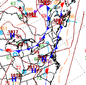
-

July 2025 Obs/Disco ... possible historic month for heat
weatherwiz replied to Typhoon Tip's topic in New England
what a supercell in far northwestern Maine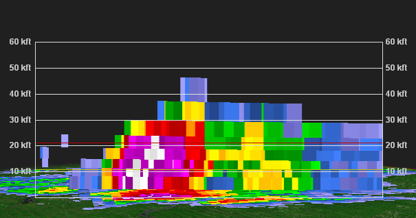
-

July 2025 Discussion-OBS - seasonable summer variability
Brian5671 replied to wdrag's topic in New York City Metro
Nice summer day here- 85 and sunny-maybe a storm later -
12z 3k NAM sweeps a line of storms through central and NE MD this evening still
-

July 2025 Discussion-OBS - seasonable summer variability
nycwinter replied to wdrag's topic in New York City Metro
warm outside but not to bad there is a nice breeze blowing.. -
July 2025 Obs/Disco ... possible historic month for heat
weatherwiz replied to Typhoon Tip's topic in New England
Is this like a weak pre-frontal trough or something? Looks like it on WV or some weak embedded shortwave trough ahead of the larger s/w trough -

July 2025 Obs/Disco ... possible historic month for heat
Cyclone-68 replied to Typhoon Tip's topic in New England
Watch coming for the north country shortly -

July 2025 Obs/Disco ... possible historic month for heat
CoastalWx replied to Typhoon Tip's topic in New England
What’s this shit moving in -

July 2025 Obs/Disco ... possible historic month for heat
mreaves replied to Typhoon Tip's topic in New England
The one here in VT is closed tomorrow. -
July 2025 Obs/Disco ... possible historic month for heat
weatherwiz replied to Typhoon Tip's topic in New England
I wonder if we get a bit of shortwave subsidence? Maybe thats why some of these HRRR runs and latest 3km are meh. -
July 2025 Obs/Disco ... possible historic month for heat
dryslot replied to Typhoon Tip's topic in New England
A line of weak cells already pushing into SVT moving E. - Today
-

Central PA Summer 2025
Mount Joy Snowman replied to Voyager's topic in Upstate New York/Pennsylvania
Low of 65. Heading out around lunch with the fam to visit some friends out towards Pittsburgh, Westmoreland County to be more precise. Should be splendid weather for 4th of July celebrations. Enjoy, everyone! -
July 2025 Obs/Disco ... possible historic month for heat
weatherwiz replied to Typhoon Tip's topic in New England
I'd watch closely. It looks like there is some sort of boundary across Connecticut...south-central Connecticut -

July 2025 Obs/Disco ... possible historic month for heat
SJonesWX replied to Typhoon Tip's topic in New England
crazy thought, but perhaps the fine people at Costco would know, rather than rando's here at amwx. check their website, or you could even *gasp* call them Edit: ninja'd by Ray -

2025-2026 ENSO
40/70 Benchmark replied to 40/70 Benchmark's topic in Weather Forecasting and Discussion
2014 is the best analog, but I didn't include it because it was El Nino. -
Pleasant day today with E winds keeping temps in the 70's. Hotter day tomorrow with 80's (90's inland with a heat adv) n stms. Could be a wash for fireworks up my way.


