All Activity
- Past hour
-
idk...good luck though
-
This is why I wanna create a kind of integrated heat content, heat wave calculation/index, so that these things can be physically ranked instead of hyperbolically so - Having said that, I'm not sure “worst in history” wrong though? France broke all-time temperature records since the invention of the thermometer came to that region, not one day ...but on consecutive days no less. Why is that wrong? Seems "worst in history" is just about precisely what that was - no hyperbole.
-
PDS
-

Central PA Summer 2026 Discussion/Obs Thread
TheDreamTraveler replied to Voyager's topic in Upstate New York/Pennsylvania
Yeah I keep seeing the temps on Saturday climbing and climbing towards 100. Would be absolutely insane if we got 4 days in a row of 100. Completely unprecedented in our current records. Any temp that gets over 103 would put us in top 10 territory for that specific day heat wise. The only single time we ever got over 104 in Harrisburg was that absurd heatwave in 1966 -
Coaching this week is gonna suck. We have a B-meet Wednesday which may be rather miserable as well. I’ll push to cancel if excessive heat warnings are issued.
-
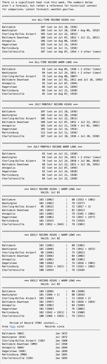
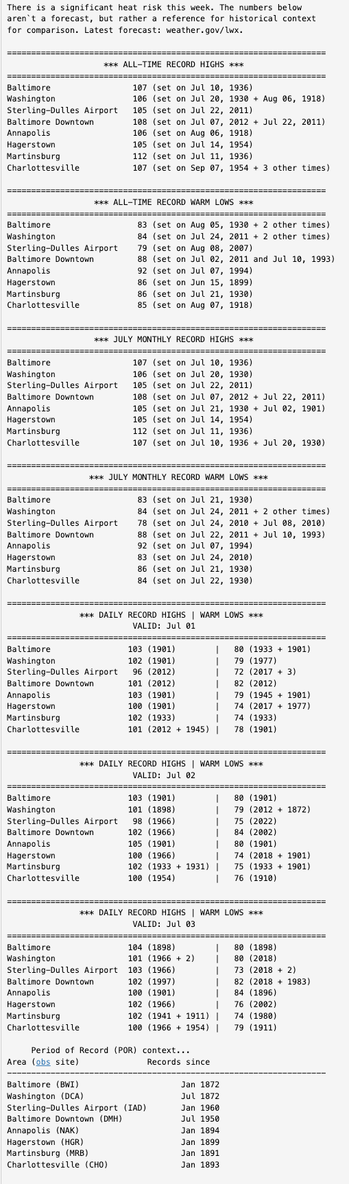
LWX Discussion had some good Climate Summary data
-
 Go_Birds joined the community
 -
88/79. Nasty. Would love to get the triple digits they're going to get back in my old stomping grounds later this week.
-
88 currently. Trying to move some flowers around today for my irrigation system since we are going away tomorrow and I'll have no one to water by hand.
-
It isn't political if someone is commenting on (with actual caveats) the reason why a website went down. It isn't opinion based, or leaning to some kind of political affiliation. As someone who does not want politics in this forum either, this does not meet the criteria for that by a long shot, and you need to check yourself. Being hypersensitive does not serve our goals either.
-
Here it was ... I guess it was mid month, altho I recall a wondering earlier because of the 'cadence' of hemispheric behavior. At the time, the modeling didn't go as far as July 1 but it's one of those extrapolation deals. Anyway, I recall now it was based purely at the time on the numerical teleconnector spreads from the various source, less so the spatial synoptic chart cinemas. In fact, I recall commenting on it since then how there was a discrepancy - it's interesting to me that the indices "won" this discovery at a very long lead. The operational runs were in fact fighting this as near as 7 days ago, however ... that's not really necessarily unreasonable given it was still 7-10 days away at that later time. But they were really just not interested. GFS was first to come around.
-

2026-2027 Super El Nino
snowman19 replied to Stormchaserchuck1's topic in Weather Forecasting and Discussion
Their argument was for a full scale turnaround to deep winter; arctic cold and snowstorms lasting for months after the rapid El Niño weakening began, not for the single anomalous blizzard and the single anomalous arctic cold snap, both in 2016. There was never a full scale turnaround in 1998 (JB) or in 2016 fDT, JB) -
 bill fortier joined the community
 -
90 here right now, so the long heat wave starts.
-
Record breaking summer heat in a super Nino... we're so cooked
-
 jpnd81 joined the community
 -
Radar looks clear. Seabreeze front very prominent on radar and is splitting Long Island almost exactly in half running east to west.
-
Actually .. not disputing this at all but I did notice the EPS sending signals for back when it was over 300 hours. I post about it around June 11th or so... I'll try to find it
-

2026-2027 Super El Nino
Dillsburg Keith replied to Stormchaserchuck1's topic in Weather Forecasting and Discussion
There was a blizzard in Jan 2016..historic for many, so they were partly right -
 Weather Badger joined the community
 -
 Uncle Gust joined the community
 -
Stop with the political stuff. Please and thank you.
-
 jim.ione27 joined the community
 -
Pulled into work and winds are blowing. Kinda makes the heat slightly tolerable. But I am watching what looks like a storm try to build to my southeast, probably south of Brooklyn and moving west/southwestish. How are we supposed to attach/add pics if the allowable size of 10kb it's reached 30 years ago? Lol jc
-
90/75 My sweat glands have activated. Quite a bit more cloud cover than I expected today.
-
90/80 imby is tough, air is just so thick. station might be running a bit warm/moist, but another PWS a couple blocks away is showing 93/81.
-
(002).thumb.png.6e3d9d46bca5fe41aab7a74871dd8af8.png) With a chance that some locations could see a 100-degree day later this week I went back and analyzed 30 temperature stations across the area to see just how rare such a day has become. A 100-degree day is a rare occurrence across most spots across the County. With the potential being even more rare across the relatively higher ridge stations above 595 ft. In fact the last time any ridge location station saw a 100-degree reading was 15 years ago back on July 22, 2011. Of the 18 current stations across the area that report temperatures 9 of these have never recorded such a day. Our lowest elevation stations at Phoenixville and nearby Spring City both recorded a 100+ day last June. To illustrate how different the temperature elevation impact can be on June 26, 2025 while Spring City (256 ft ASL) was hitting the century mark....not too far away at Glenmoore DEOS (620 FT ASL) but 400 feet higher the high was 10 degrees cooler at "only" 90.6
With a chance that some locations could see a 100-degree day later this week I went back and analyzed 30 temperature stations across the area to see just how rare such a day has become. A 100-degree day is a rare occurrence across most spots across the County. With the potential being even more rare across the relatively higher ridge stations above 595 ft. In fact the last time any ridge location station saw a 100-degree reading was 15 years ago back on July 22, 2011. Of the 18 current stations across the area that report temperatures 9 of these have never recorded such a day. Our lowest elevation stations at Phoenixville and nearby Spring City both recorded a 100+ day last June. To illustrate how different the temperature elevation impact can be on June 26, 2025 while Spring City (256 ft ASL) was hitting the century mark....not too far away at Glenmoore DEOS (620 FT ASL) but 400 feet higher the high was 10 degrees cooler at "only" 90.6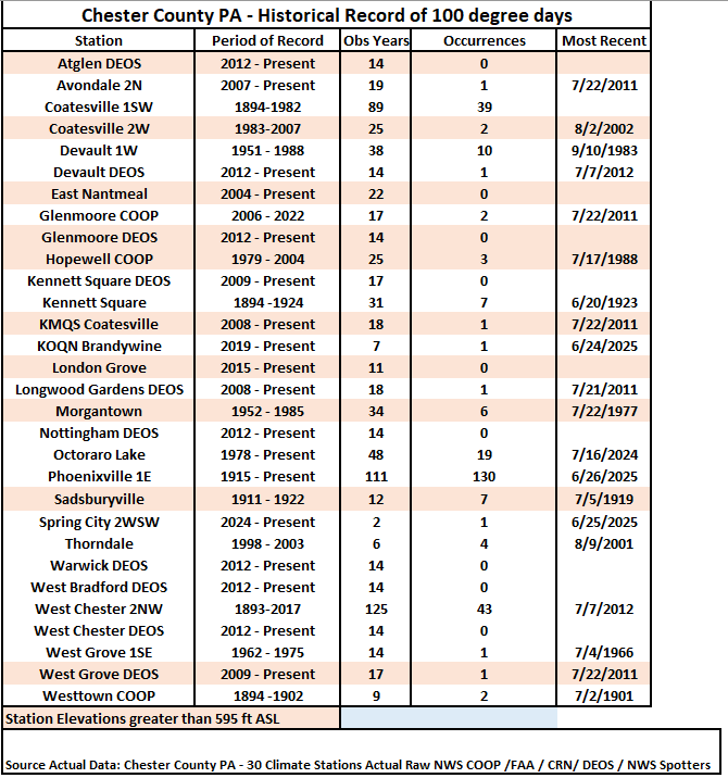
-

E PA/NJ/DE Summer 2026 Obs/Discussion
Mikeymac5306 replied to PhiEaglesfan712's topic in Philadelphia Region
Got an email from the guys doing the 250th parade Friday in Philly. They are cutting the route down to one mile rather than the 2.4 miles it was planned for. They are adding extra water stations and have SEPTA buses on standby for cooling areas. -
LOL, I was building a case! AI makes it easy in today's world. I should tell you sometime about all the acrobatics I went thru during the late 60's to construct a temperature measuring shelter to NWS standards!!
-
Maybe. My older brother was in the Corps of Engineers and during the monsoon season of his Vietnam year (1967 into 68) there would be thunder and torrential rain 3-5 PM, so regular that one could almost set one's watch by the storm times.


.thumb.jpg.ad3a2e31d30aff035044689b311a0540.jpg)

