All Activity
- Past hour
-
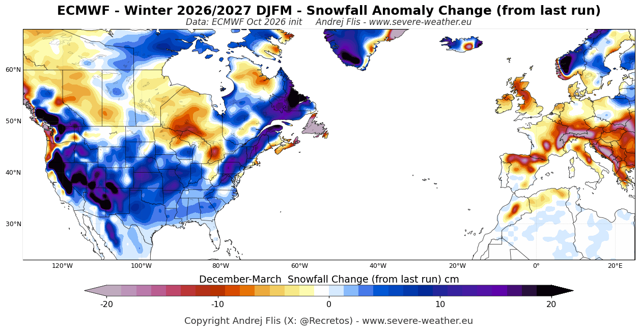
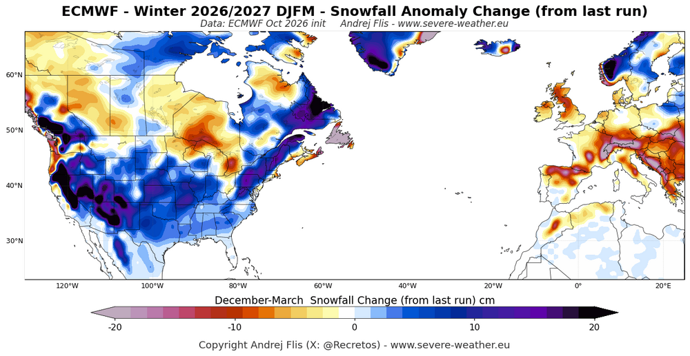
Latest Snow anomaly map from EURO seasonal. Source: severe Weather Europe
-
Luckily, my power was only out for 24 hrs. Took down a bunch of trees. But borderline TS to Cat 1 systems don’t get retired unless they cause historic flooding like Agnes in 1972.
-

2026-2027 Fall/Winter Mountain Thread
Tyler Penland replied to BlueRidgeFolklore's topic in Southeastern States
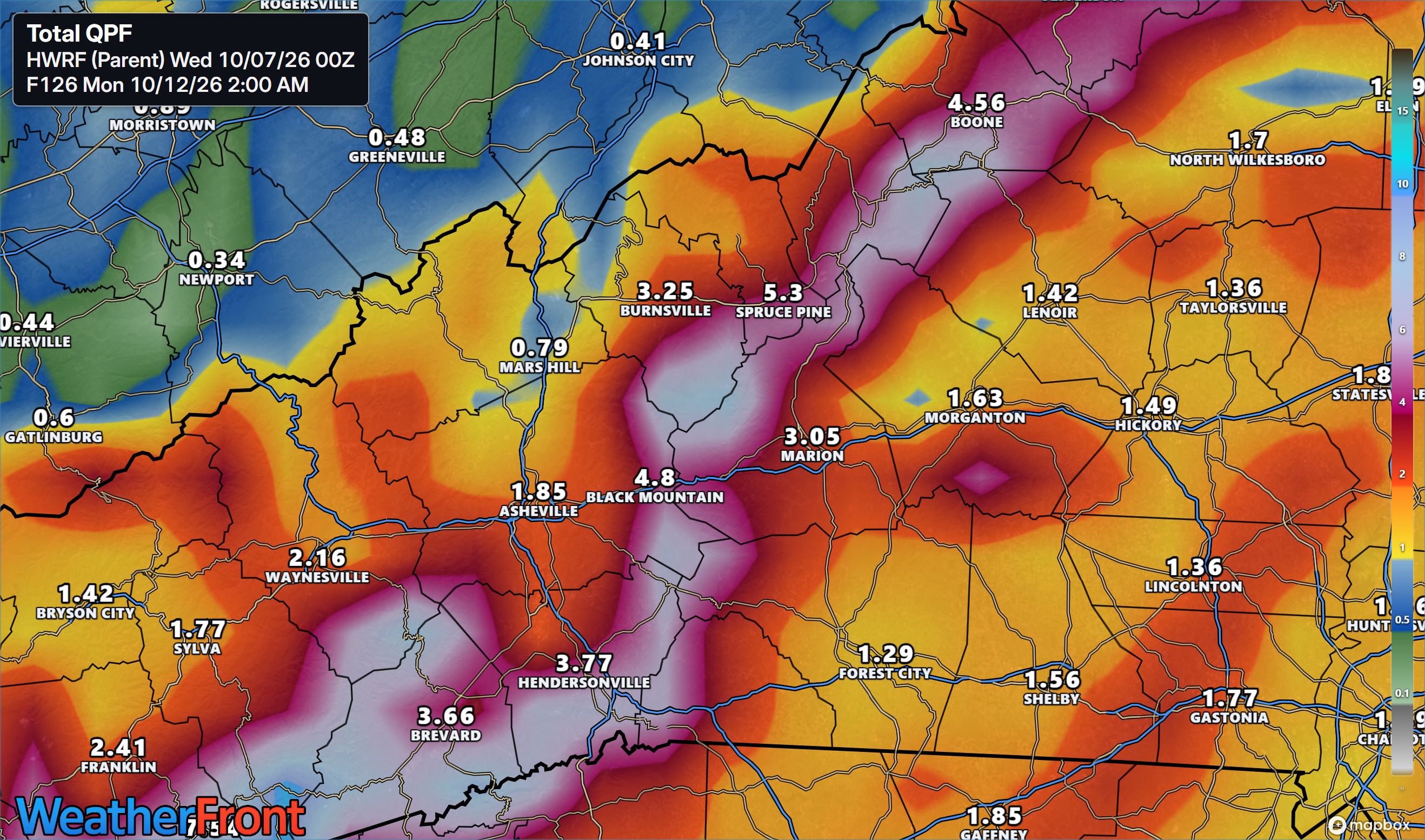
HWRF slams the escarpment on rainfall. A further east track sets up nearly perfect enhanced southeast flow. It bumps PWATs up to nearly 2" with 30-40kt southeast winds at 925mb.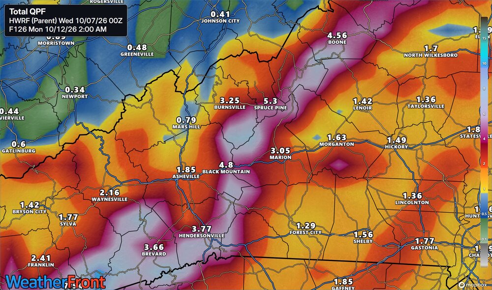
-
Recon will tell us a lot here shortly. If this is going to make a run at a major, the bones need to be there now. A tight developing core would mean this likely goes major. Anything strung out and it probably doesn’t have time before shear inhibits it
-
October 7 2003: Record high temperatures are seen across the area. St. Cloud's high is 86 degrees. Minneapolis ties their record high of 85 degrees set in 1997, and Alexandria sets their record high of 88 degrees. Forest Lake reaches a record-setting 82 degrees, along with Stillwater at 84 degrees. 1980: Summer-like heat occurs over Minnesota with highs of 92 at Montevideo and 84 at MSP airport. For Wednesday, October 7, 2026 1970 - Widespread flooding took place across Puerto Rico. Rainfall amounts for the day ranged up to seventeen inches at Aibonito. A slow moving tropical depression was responsible for six days of torrential rains across the island. Totals in the Eastern Interior Division averaged thirty inches, with 38.4 inches at Jayuya. Flooding claimed eighteen lives, and resulted in 62 million dollars damage. (David Ludlum) (The Weather Channel) 1981 - Seattle, WA, received four inches of rain in 24 hours, a record for the city. (The Weather Channel) 1987 - It was another hot day in the southwestern U.S. Tucson, AZ, hit 101 degrees for the second day in a row to again equal their record for the month of October. Phoenix AZ reported a record high of 103 degrees, and Blythe CA and Yuma AZ tied for honors as the hot spot in the nation with afternoon highs of 108 degrees. (The National Weather Summary) 1988 - Morning fog in the central U.S. reduced the visibility to near zero at some locations. Morning lows of 28 degrees at Rockford IL and 24 degrees at Waterloo IA were records for the date. Afternoon highs of 92 degrees at Hollywood FL and Miami FL were records for the date. (The National Weather Summary) 1989 - Morning thunderstorms in central Texas drenched San Antonio with 3.10 inches of rain in six hours causing local flooding in northeastern sections of the city. Temperatures dipped below the freezing mark from the Northern Rockies to the Upper Mississippi Valley. (The National Weather Summary) Observances: 7 Wed World Cotton Day 7 Wed National Kale Day 7 Wed National Walk and Bike to School Day 7 Wed National Inner Beauty Day 7 Wed National Frappe Day 7 Wed Random Acts of Poetry Day 7 Wed World Financial Planning Day 7 Wed International Day of Peaceful Communication 7 Wed National Forgiveness & Happiness Day 7 Wed National LED Light Day 7 Wed You Matter To Me Day
-
The same by me in Commack. Lots a bunch of trees. Sandy was much worse. But Isaias was very destructive
-
We're definetly going to see much needed rain. How much looks dependent on how far west the TC tracks. Hopefully we see the rain without the wind.
-
Either possible solution faces the inevitable 30 to 40 knot shear prior to landfall.
-
From a public messaging perspective idk if we want to fall victim to ensuring everyone this falls apart before landfall especially if this, say it peaks as a cat 4 18 hours from landfall, and is roaring to the coast at 20 mph. That’s a big gamble
-
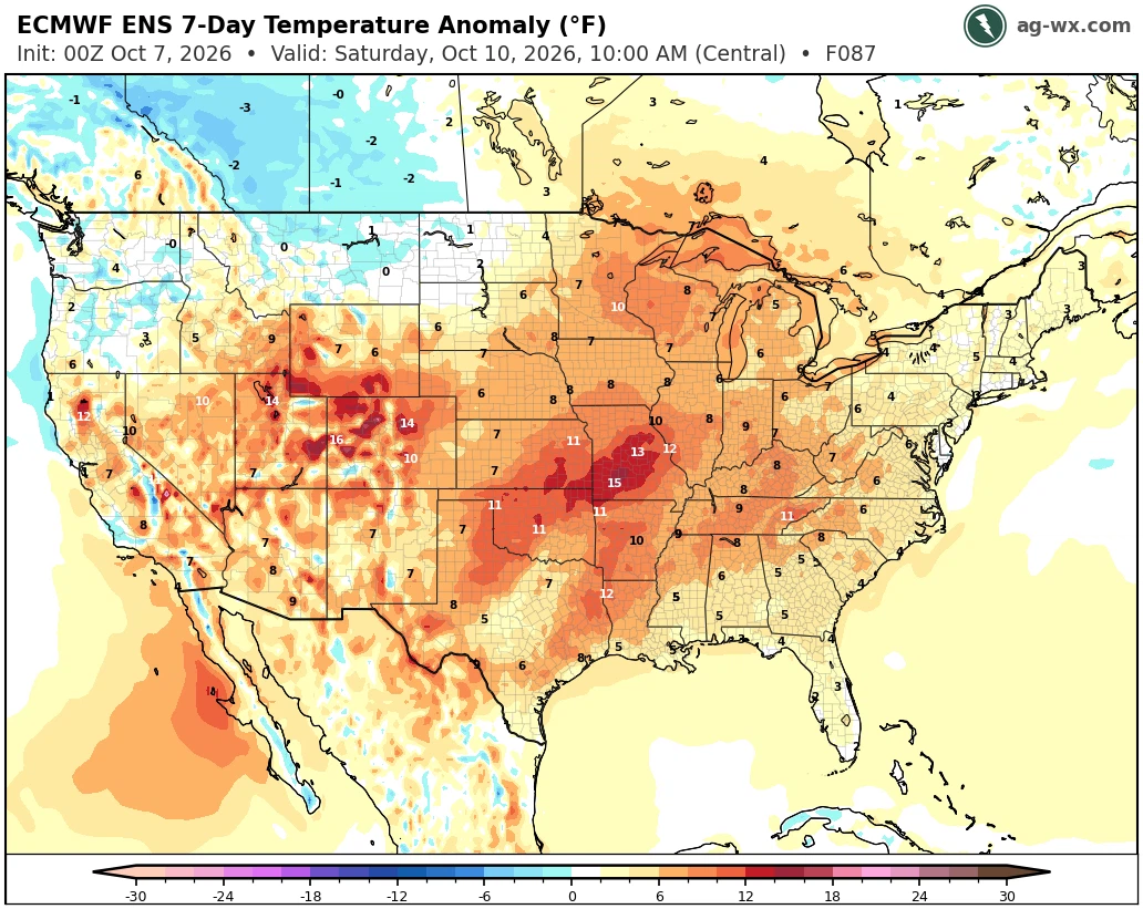
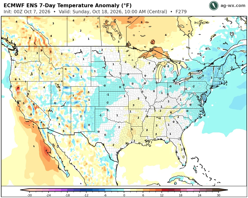
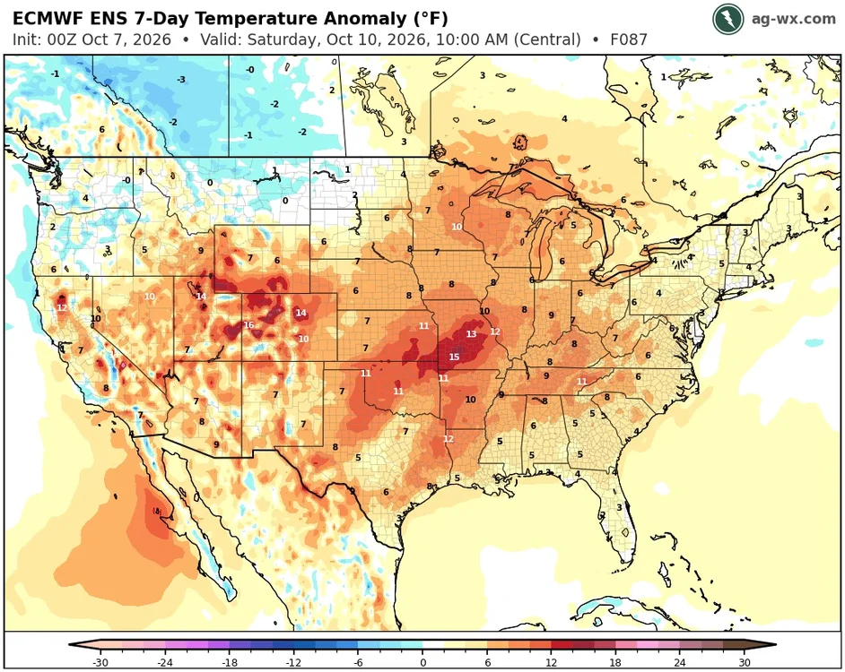
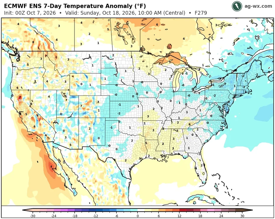
The cooldown next week following this warmup will possibly deliver the first freeze of the season for the colder spots across the region that radiate well.
-
Being in southwest Suffolk I can tell you how serious Isaias was here. We had no power for about 8 days. Trees down everywhere. It was worse than Sandy for us personally
-
Side comment - I think we will see 1-3 named storms after this one with about a 50% chance of of another hurricane (likely in the subtropics). But yeah, it's pretty comical that this one seems to be defying many of our expectations.
-
Lilly is about the most profound example that I can recall...went from about 145mph to 100mph upon LF near the TX/LA border in 2002.
-
I am starting to lean into a major being a real possibility, but I still anticipate it getting hammered in the mid-levels prior to landfall. Wouldn't even be surprised if it got decapitated. 30+ kts of shear is still going to win the battle, regardless of the vector of motion and all other favorable factors. Keep in mind that some of the 500 hPa barbs of flow may be in excess of 50 kts by landfall. I would still be cautious of early onset RI being a sure thing as well. It may thread the needle, but you can clearly see assymmetry already in the cloud pattern, and the coldest tops are NE of the surface circulation. It may be slower to moderate intensification instead if it gets hampered by westerly flow. You can easily see this flow on satellite moving in quickly from Mexico. Again, RI is a possibility, but absolutely not certain.
-

E PA/NJ/DE Autumn 2026 Obs/Discussion
MGorse replied to PhiEaglesfan712's topic in Philadelphia Region
Low here of 40 earlier this morning. -
41.1 here. Wind stayed up on the hill last night. Heat kicked on as well
-
It's easy to grow complacent and fall victim to recency bias, and I know we have had some feast right up to the shore in the gulf of late, but I don't think this is Michael.
-
37 at the house this morning. No frost in town, but rural areas had white lawns.
-
Not to undermine hydro concerns, which will be plentiful near the shore, but hopefully progressive enough to limit freshwater flooding.
-
It's easy to forget because of our unprecedented streak of strengthening hurricanes at landfalls in the GOM, but I remember how in the early 2000s it felt inevitable that significant weakening would occur at landfall along the GOM coast
-
The super ensemble, deep mind ensemble, and every other model ensemble is there on the site. You have to click the storm itself and then it brings up the storm specific information, in which you can toggle to model ensemble data https://polarwx.com/tropical/#al092026/ensembles
-
Agreed 100%. I don’t see how this doesn’t weaken and possibly significantly before landfall but it might be too late. That extremely fast motion into the coast is going to make this dangerous and likely have some jet streak interactions which could help it hold onto intensity longer than usual. I’m convinced tho that this exceeds most guidance (not unusual at all for this location especially with a small storm) in the short term
-
Heat isn't turned on til Nov at the earliest..barring some anomalous artic air mass. Plus, oil prices are...you know.
-
 buy amoxicillin antibiotic [url=https://antibiodirect.com/#]AntiBioDirect[/url] over the counter antibiotics