All Activity
- Past hour
-
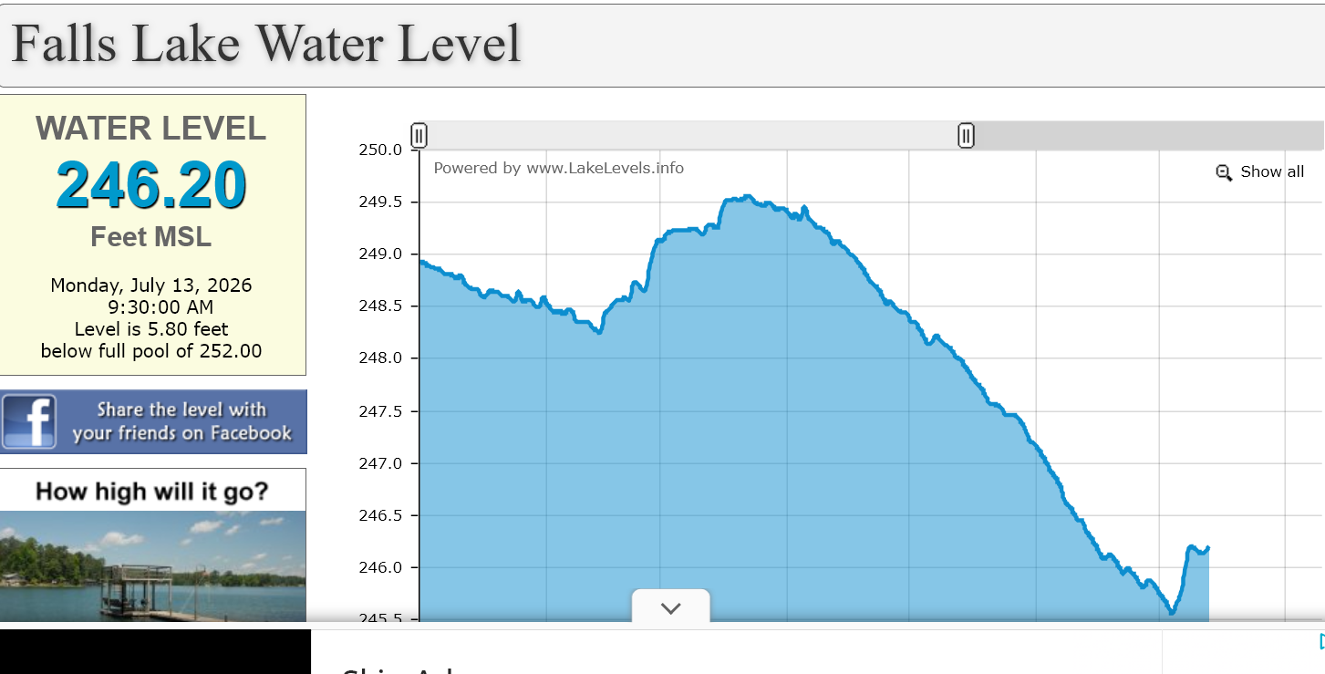
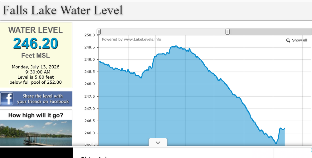
Falls Lake has risen by nearly a foot since all of this rain and will likely climb a bit more today.
-
 It probably doesn't make it very far south at all. Looks like this will weaken quickly as it drops south across VT/NH. I do think there is still a shot for some storms in SNE on Wednesday south of the Pike, especially if the front can time a little slower. But convergence will be lacking and we may be drying out aloft quickly b/c the 850/700 front move through prior to the sfc front. I wouldn't totally sleep on it because if there are storms Wednesday there will be a increased risk for strong/severe
 -
Kind of funny that an "all time" record doesn't even span 80 years.
-
something about 100+ in detroit and 89 imby feels weird but i'll take it
-
1.77 the last 12 hours and 2.06 the past 24 hours
-
 How far south does the line make it?
 -
Shocked that they're only going with a heat advisory and not a warning.
-
Yeah, sure! Whether it's 97 or 100 it's going to be crazy hot, might as well set a record. I'm pretty much down for any extreme type of weather. I have frozen watermelon and ice water for the chickens, and frozen baby carrots for my bunnies to munch on. Hopefully that will keep them from getting too hot this afternoon.
-
And the power companies can trim all around the lines, still can have a tree 40Ft take out the span. I spent 2 weeks in the FL Pan Handle for work doing recovery and breath taking what CAT 5 damage looks like. Having food for at least 2 weeks and tarps/plywood for roofs are some of the immediate needs. Dorian was 75 miles off our coast before turning, thought it was lights out with that one but thankfully we were spared.
-
 Another 1938 would leave some people w/o electricity for months. Connie/Diane had incredible rain, especially in SNE, but I don't recall much wind in NNJ. Floods kill and destroy but usually don't mess up the grid like wind/ice/Octobombs.
 -
 lots of clouds with convection rolling through the central part of the state
 -
 Falls under the heading of people being careful what they wish for. The impacts will be far greater and far more long lasting than they think it will be. Why anyone wants the devastation of a redux of 1938 is beyond me. All I can say is some of them folk better have a plan in place to protect themselves, their families and their belongings..the hassle of finding people to repair the damage is going to pale in comparison to the protection aspect of the recovery....
 -
Over 50 knots of bulk shear with > 1500 MLCAPE within western Maine tomorrow evening on the 12z NAM ahead of that activity approaching from Quebec
-
 Lots of smoke up there today . Burning
 -

2026-2027 Super El Nino
GaWx replied to Stormchaserchuck1's topic in Weather Forecasting and Discussion
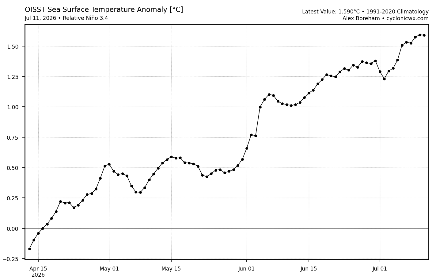
Nino 1+2 came in at +2.6 vs my guess of +2.7 to +2.8. Nino 3.4 rose only from +1.2 to +1.3 vs my guess of a rise to +1.4. The daily relative 3.4 OISST graph (see below) had suggested a rise of 0.2 rather than 0.1. Perhaps the rise was just under 0.15 and this rounded down to a rise of 0.1? But also, the image below of relative OISST for 3.4 suggests the relative 3.4 for last week (7/5-7/11 or the last 7 dots) was actually ~+1.5 (actually a little warmer than +1.5). So what’s going on? How come NOAA had it at only +1.3 being that they state it is OISST based? The +1.3 and this chart don’t jibe: 01JUL2026 2.7 1.5 1.2 0.5 08JUL2026 2.6 1.7 1.3 0.5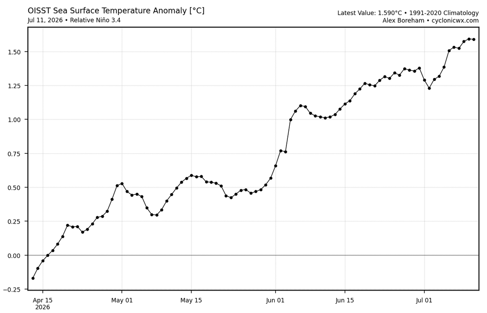
-
 This is interesting wording for NNE tomorrow: Given the degree of instability and strength of the flow, severe thunderstorm winds are likely (some significant). Large hail will also be possible with any storms. Additionally, forecast soundings show enough low-level curvature to support a tornado threat, including a strong tornado or two, with any sustained surface-based supercell.
 -
(002).thumb.png.6e3d9d46bca5fe41aab7a74871dd8af8.png)
Central PA Summer 2026 Discussion/Obs Thread
ChescoWx replied to Voyager's topic in Upstate New York/Pennsylvania
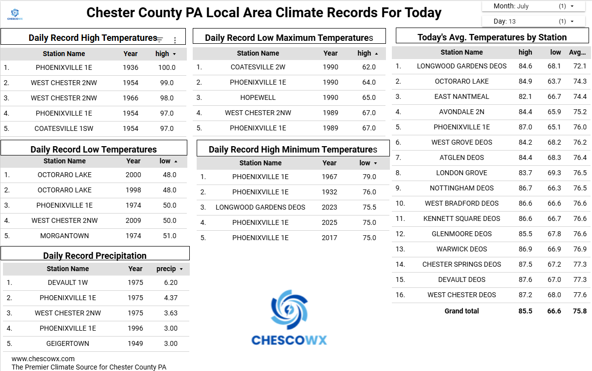
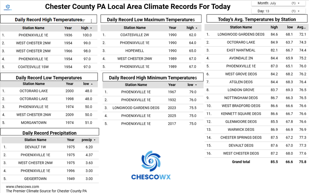
Several of our valley locations this morning saw lows down into the 50's with the ridges remaining in lower 60's. The lowest I could find was 56.3 at the Warwick DEOS. Today will be our 6th below normal temperature day over the last 8 days. We turn that around tomorrow with highs well into the 80's with 90's in the valley spots. Widespread 90's on Wednesday before we back off several degrees by Thursday. So not many spots across Chesco will get to "enjoy" the so called "heat wave" this week. By next weekend we return to near normal temperatures with increasing chances of some showers.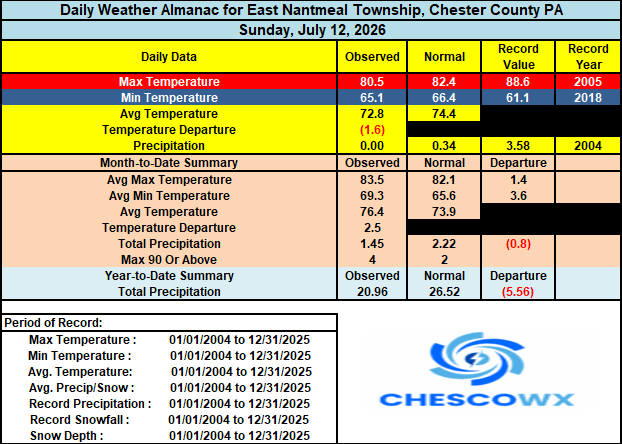
-
And what people are not going to realize to when it comes to the power companies is a 38-like track would mean substantial power outages from LI through New England and probably even into eastern NY. All these markets would be tied up...we would obviously have to rely on help from other states but with the help that would be needed...I don't think we would be able to get the help needed. Obviously first priorities are going to be police/fire/hospital grids. Any people sharing those grids will be the luckiest...at least in terms of getting power restored quickest.
-
E PA/NJ/DE Summer 2026 Obs/Discussion
ChescoWx replied to PhiEaglesfan712's topic in Philadelphia Region
Several of our valley locations this morning saw lows down into the 50's with the ridges remaining in lower 60's. The lowest I could find was 56.3 at the Warwick DEOS. Today will be our 6th below normal temperature day over the last 8 days. We turn that around tomorrow with highs well into the 80's with 90's in the valley spots. Widespread 90's on Wednesday before we back off several degrees by Thursday. So not many spots across Chesco will get to "enjoy" the so called "heat wave" this week. By next weekend we return to near normal temperatures with increasing chances of some showers.
-
Having spent 9yrs in S FL I have a new appreciation for preparedness. Most folks (not all) had some sort of season storm kit with food and other supplies. All it’s going to take here is a strong Cat 1 or 2 and people will be out of power for a couple of weeks losing their shite on the power companies. We have have had significant tree growth since Gloria and Bob and many have not idea what widespread tree damage will look like.
-
please please let it happen.. I know many people here that don't think a Hurricane can even happen here.. the ones that do say it wont be bad even if one hit.. I honestly hope a big one hits soon!
-
Beats my longest - 6 days from the Jan 1953 ice storm on the hills north and west from NYC. 2nd place is 101 hours from the Dec 18, 2023 gales/flood and 3rd was 90 hours in Jan 1998. We were fortunate in that last one - a single break between Brunswick Avenue and our place 400' away would've meant 2 weeks. (Our phone was out for 13 days.)
-
I think we may see 10%/45%/30% on new D2
-
 You and PF may want to keep an eye on this.
 -

2026-2027 Super El Nino
40/70 Benchmark replied to Stormchaserchuck1's topic in Weather Forecasting and Discussion
If possible, 1941-1970 and 1961-1980 would be ideal.