All Activity
- Past hour
-

2026-2027 Fall/Winter Mountain Thread
Maggie Valley Steve replied to BlueRidgeFolklore's topic in Southeastern States
Fairly significant pressure drop recorded by RECON a couple of minutes ago. Looking more likely we have a CAT 4 now. -
One thing shear is doing is going to work on eyewall symmetry. Half-a-cane look starting. Hopefully that starts the weakening process. This current convective burst and little change with the CDO seriously lessen the chances of significant weakening but you can tell this storm is simply being held in check atm
-
I'll just add note the deep convection with lightning that continues to fire around the center. As long as that happens, this isn't weakening any.
-
I see 951.6mb extrap. A very substantial fall.
-
My God what does it take for the football talk to get taken to banter?
-
Why so windy.
-
You know everyone is grown adult and can choose to go or not. Adults make choices.
-
Uh oh -- so much for leveling off ....
-
Huntley in, Lamar out https://www.espn.com/nfl/story/_/id/50141743/ravens-qb-lamar-jackson-huntley-start-snf-vs-falcons
-
Whoa, need confirmation from the drop, but 952.8 MB extrap , vs the pass before at 958.0 (drop was 963)
-
We have about 8-9 hours til landfall. So it's a race against time with the shear. The storm has done a remarkable job fighting it off. No doubt the very warm, undisturbed gulf and jet stream alignment helped big time.
-
-
Doing a darn good job of fighting off the dry air trying to get ingested from the west. Robust convection most of the western half of the circulation. More new convection popping NW on the center. https://www.meteo.psu.edu/ewall/PSUGOES_US/loop60w.html https://www.meteo.psu.edu/ewall/PSUGOES_MESO2/loop60i.html Northern eye wall looking solid. https://weather.cod.edu/satrad/nexrad/index.php?parms=EVX-N0Q-1-48-100-usa-rad
-
Yep.
-
 I disagree with a monster N. Pacific trough in the DJFM mean, in the reality of what will happen.
 -
Pittsburgh Area Fall 2026
RitualOfTheTrout replied to Ahoff's topic in Upstate New York/Pennsylvania
Picture of me waking up from summer hibernation getting ready to track some snow!
-
-

2026-2027 Record-breaking El Nino
GaWx replied to Stormchaserchuck1's topic in Weather Forecasting and Discussion
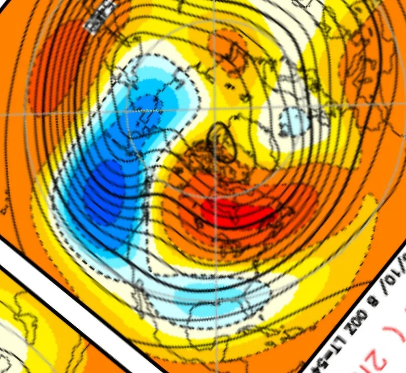
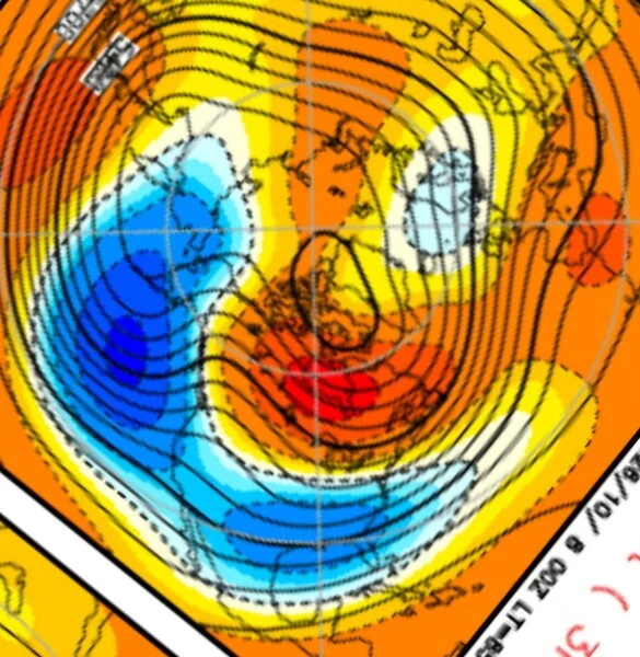
New JMA H5 winter maps from NE forum post: this is what it appears to me that the maps are showing DJF: strong +PNA, ~neutral EPO, -AO, ~neutral NAO Dec: slight +PNA, ~neutral EPO, slight -AO to neutral AO, slight +NAO Jan: strong +PNA, ~neutral EPO, -AO, ~neutral NAO Does anyone disagree with my opinion on what these maps are showing for these indices?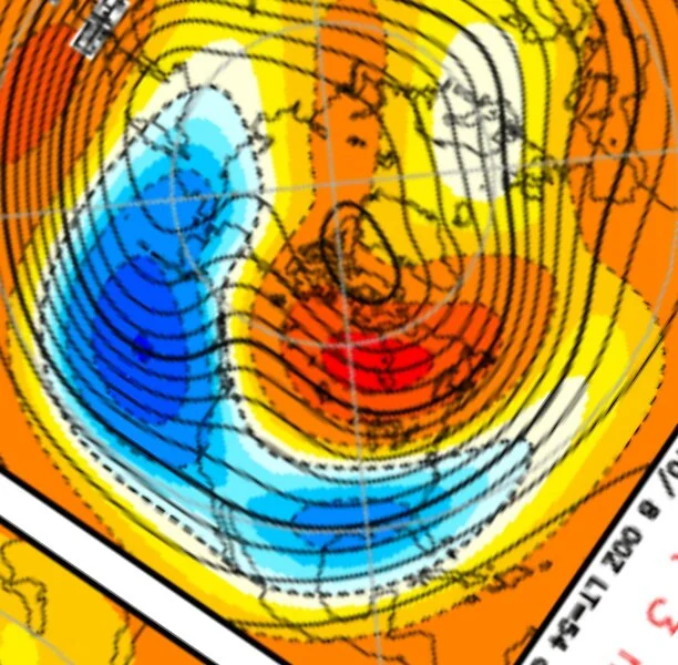
-
All of the really deep convection today has been on the Western side of the circulation. I believe the Eastern side has been getting choked off some by the drier air wrapping in.
-
lol yep. Like insult to injury.
-

2026-2027 Fall/Winter Mountain Thread
Met1985 replied to BlueRidgeFolklore's topic in Southeastern States
Yeah Steve just texted me this info. This is very impressive. -

2026-2027 Fall/Winter Mountain Thread
BooneWX replied to BlueRidgeFolklore's topic in Southeastern States
Per recon, it’s flirting with cat 4. It’s defying all of the odds. Never bet against a Gulf cane. -
8.0 earthquake in Panama
-
and all these gorgeous days during the week of course
-
2026-2027 Fall/Winter Mountain Thread
Met1985 replied to BlueRidgeFolklore's topic in Southeastern States
Well folks this looks legit with everything coming together. We all new that we couldn't keep avoiding this type event again. Hurricane, moving fast, high winds, heavy rainfall, possible power outages and flooding. As we all know this isn't Hurricane Helene but this is a powerful Hurricane. Batten down the hatches and prepare now. As we all have known it's better to be prepared for the worst than be in a vulnerable position. Everyone post as much as you want and can about this upcoming event. We all need to stay on top of this.