All Activity
- Past hour
-

2026 Atlantic Hurricane Season
WxWatcher007 replied to Stormchaserchuck1's topic in Tropical Headquarters
Looking more like a Campeche window than Gulf now. Would be a win for AI. Forget hitting the snooze button. Pull the alarm clock out the wall, chief. -
This is beautiful to see in the Summer

-
-
Lake breeze saving the day but humidity def up
-
12z euro is very active with the N stream.. has like 8-10 chances to whiff on storms over the next two weeks. Hoping one or two work out
-

Central PA Summer 2026 Discussion/Obs Thread
canderson replied to Voyager's topic in Upstate New York/Pennsylvania
I hit 80but yup the humidity is not there thankfully Wow at your wind. I had nothing above 15 mph lol -
Silly auto correct got me
-
Violence Thursday on the 18z NAM.
-
I see what you did there! Our soil is definitely the most dire
-
Today's rain was a total dud here. It rained west of here all day and then it moved over my area finally and was a 20 minute light shower.
-
Microclimates due to terrain effects, mostly in the western areas(orographic lift/rain shadow) largely determine winners and losers. In areas at lower elevations it is random in a lot of cases, but there are localized boundaries that can help trigger storms due to bay/sea breezes enhancing lift in some cases. When a legit cold front runs into a warm, unstable airmass the chances for more widespread coverage of storms is increased, but there will still be locales that maximize more than others. Again over time, that seems to even out. A linear/elongated line of storms(QLCS) probably gives the best chance for all in the affected area to be impacted in a similar way.
-
Still can’t get 3 days without any rain!
-

2026-2027 Super El Nino
FPizz replied to Stormchaserchuck1's topic in Weather Forecasting and Discussion
I'm pretty sure we will all pull through just fine... -

2026-2027 Super El Nino
Stormchaserchuck1 replied to Stormchaserchuck1's topic in Weather Forecasting and Discussion
Pretty strong Solar Max 2-3 years ago. We are hitting this +ENSO +time wrt Solar Cycle. Based on the far extent of the aurora borealis and now how strong this El Nino is getting, it is possible that the Solar Max as reported was underestimated, or the Earths magnetic field is weaker (just an unsubstantiated theory). -
2026-2027 Super El Nino
Stormchaserchuck1 replied to Stormchaserchuck1's topic in Weather Forecasting and Discussion
I think it's just catching up to the -ENSO state we have held since 1998. ENSO tends to balance, historically. The thing with global temperature is that it would have actually been going higher if we had an equal number of + an - ENSO events over the last 28 years! - Today
-

2026-2027 Super El Nino
SnoSki14 replied to Stormchaserchuck1's topic in Weather Forecasting and Discussion
It's not clicking with people who don't live in reality -
Nino pattern finally kicking in
-
My region is forecast to get down to 50F tonight so 40s are in the cards. Even with all this heat we still manage to see some pretty cool readings.
-
Calvert County soils appear to be the driest west of the Bay. 0.01" water content in Lusby!
-
Well I guess its cooler if you're going to compare 86 versus 93 lol.
-
Meager 0.04” is all we could muster in Minneapolis. Almost comical how all this precipitation keeps missing us. At least there is active wx in the region to look at.
-
At least the folks whining about needing more rain will get their wish.
-
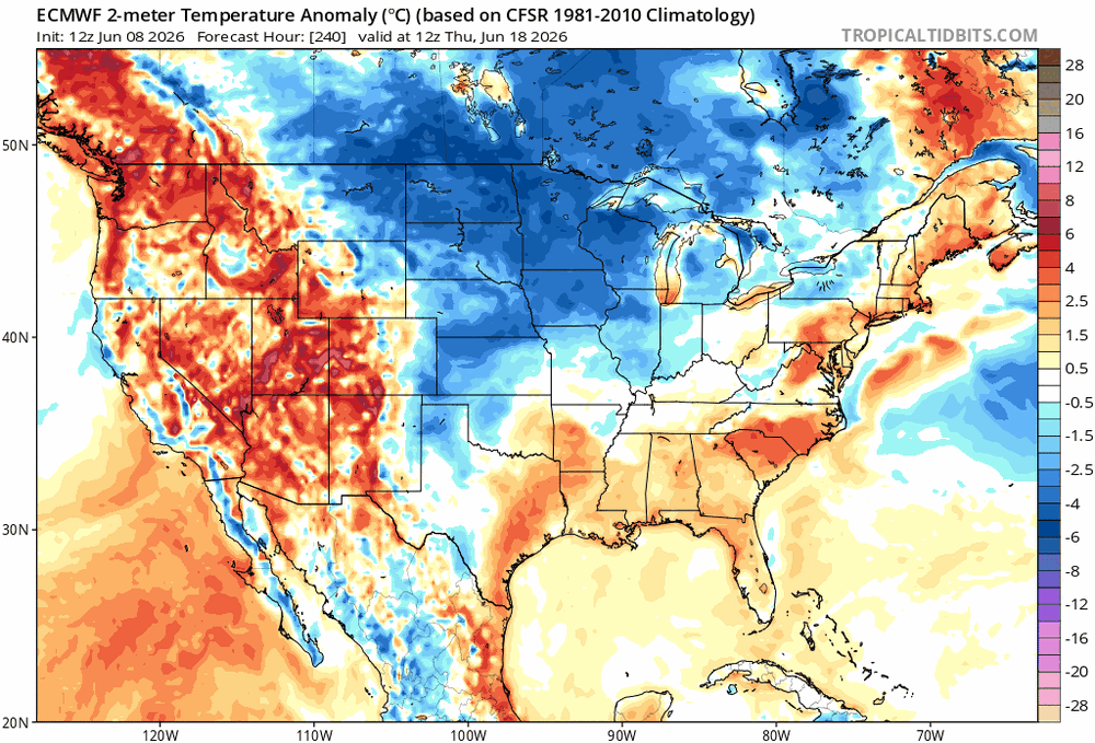
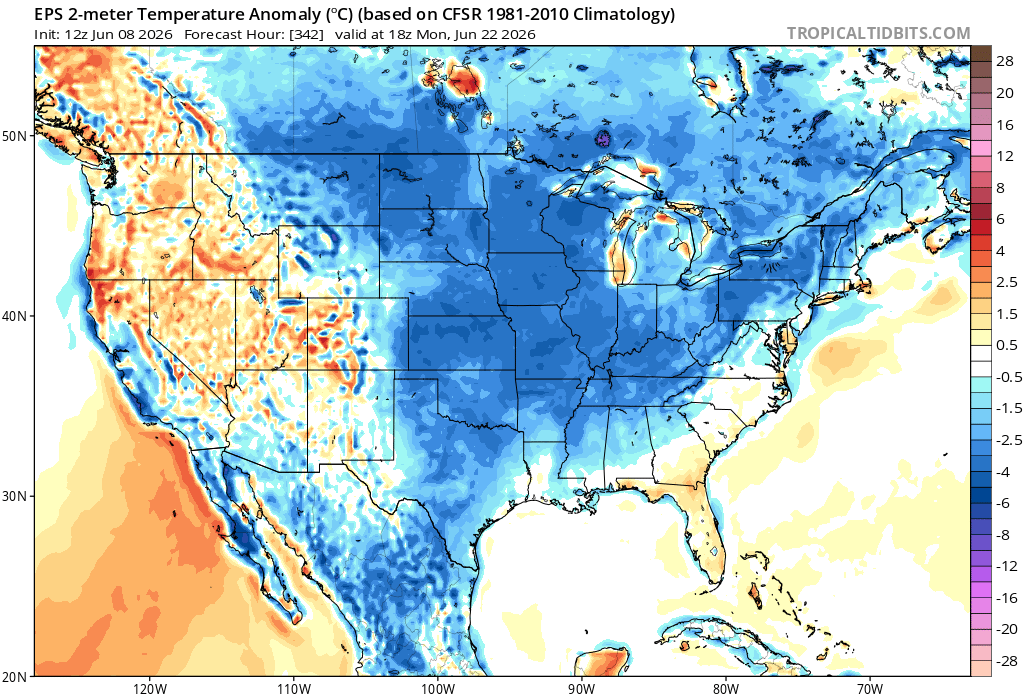
Looks cooler to me ... It may be transient but it's hard to ignore or gaslight a -2 SD seasonal regression spv rollin through the Lakes. It may be overselling in the runs and destined to normalize some... okay, but just as is? that's definitely colder.
-
Summer's over.
-
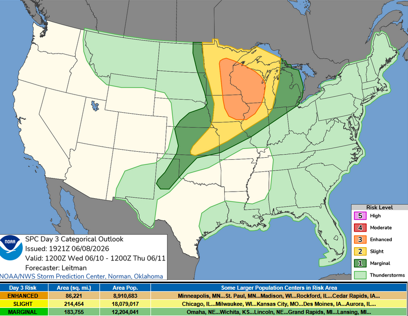
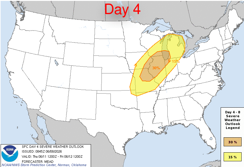
I never start threads but I thought there should be one for this with a Day 3 enhanced and Day 4 30% severe delineation already posted. Smarter people can discuss.


.thumb.gif.f92b16c631a1d15d405ed77b33f0710d.gif)


