Search the Community
Showing results for 'dr dew'.
-

May 2024 Discussion - Welcome to Severe Season!!!!
Patrick-02540 replied to weatherwiz's topic in New England
Temperature 82.9 °F 53.4 °F 66.2 °F Dew Point 73.2 °F 53.1 °F 61.9 °F Hit dew high of 73.2 today at 4:05, same time my high of 82.9 came in. Pretty steamy. -

May 2024 Discussion - Welcome to Severe Season!!!!
Torch Tiger replied to weatherwiz's topic in New England
Memorial dew weekend looking decent! -
First 70º dew point of the year this afternoon across eastern Iowa.
-

May 2024 Discussion - Welcome to Severe Season!!!!
Damage In Tolland replied to weatherwiz's topic in New England
Dendy’s dew is 71! -

May 2024 Discussion - Welcome to Severe Season!!!!
powderfreak replied to weatherwiz's topic in New England
It’s a given. Something has changed pattern wise that doesn’t let cP air masses sink down here enough to get low dews with warm days. Its all cT and mT air all the time… and if we do cool off it’s mP air and still elevated moisture levels. Melting the permafrost off/northward and changing the source region dynamics, along with prevailing global circulations lately, seems like it’s a slam dunk going forward for above normal temps and elevated dew points. Hit 85F up here today. We seem to have some high-end heat relative to climo in May over the past 5 years… only to struggle to those temps again for sometimes a couple months. Wonder if we can get near 90F as 850-925mb temps warm a couple degrees. -
May 2024 Discussion - Welcome to Severe Season!!!!
powderfreak replied to weatherwiz's topic in New England
Ha yeah it wasn’t chilly here. Max of at least 84F and full sun. ASOS dews 56-61F. Currently 61F dew. Mid-80s and dews around 60 is mid-summer climo here, lol. Definitely a touch cooler/drier down your way in E.MA.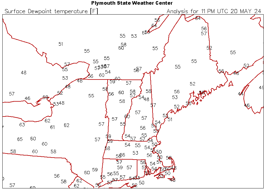
-

May 2024 Discussion - Welcome to Severe Season!!!!
kdxken replied to weatherwiz's topic in New England
Sissy. Actually feels kind of chilly here with these low low dew points. Hard to work up a sweat. -

May 2024 Discussion - Welcome to Severe Season!!!!
RUNNAWAYICEBERG replied to weatherwiz's topic in New England
Yea low dew MDW. Monday it creeps up into the 60s but Fri-Sun is coc’d. Enjoy! -

May 2024 Discussion - Welcome to Severe Season!!!!
metagraphica replied to weatherwiz's topic in New England
Hit 74 earlier. Back down to 68 already. Dew point is in the upper 50's though, so we got that going for us. -
PDS severe thunderstorm watch for northwestern Oklahoma and much of Kansas. 50/20 tornado probabilities too. Recent WoFS runs show expected storm modes nicely: clustered, bowing segments in Kansas with isolated supercells in northwestern Oklahoma. Low level moisture is over performing some progs. Upper 60s dew points are common across western Oklahoma with lower 70s not far downstream with a 25-30 knot low level jet already in place. 15-25 knot, backed near-surface winds will keep moisture streaming NW. Live updating dew point map: 18z NAM is very bullish, showing several supercells along the dryline from western Oklahoma, even down to western north Texas by early evening. I’m not sure I buy that, but regardless, any sustained convection in western Oklahoma will have the potential to produce significant severe. Edit: Now the 19z HRRR initiates a tail end supercell just south of I-40 in western Oklahoma.
-
May 2024 Discussion - Welcome to Severe Season!!!!
Damage In Tolland replied to weatherwiz's topic in New England
Honestly all joking aside. Everyone is ready . The times of 56 and rains are old and done . Let’s enjoy these next few months . Winters blow now . So let’s dew summer. -
Having reviewed 00z guidance, it certainly looks interesting near western Oklahoma early Sunday evening. Models show troughing across the High Plains with subtle lee cyclogenesis over southwestern Kansas. A belt of enhanced upper level flow should reside from New Mexico across the OK/TX panhandles and into Kansas as the mid level wave ejects. Convective initiation seems likely by mid afternoon near an effective triple point over SW Kansas and with warm advection farther north in central/northern Kansas near a pseudo warmth front. Capping and initially larger T/Td dew point spreads along the dryline over the eastern Texas panhandle will delay convective initiation until late afternoon. With that said, most 00z CAMs show at least one or two isolated storms going up ahead of the dryline by 22-00z. If sustained convection is realized, any storm would move eastward, into western Oklahoma, where increasingly richer moisture will reside. This along with an increasing low level jet would conditionally favor intense supercell development and an associated tornado threat. Given that messy storm modes are more likely across Kansas, the southern target certainly has my attention. Especially given a southern stream perturbation pointing right at the dryline, just south of the surface low.
-
May 2024 Discussion - Welcome to Severe Season!!!!
powderfreak replied to weatherwiz's topic in New England
I find myself looking at it as the warm season and cold season. We are now solidly in the warm season. Summer or spring is a semantics argument. It’s moving away from looking for ways to heat the living space, to windows open or A/C. Cold or warm season… it’s a gradual transition but feels like it’s been made. Natural snow is melting off the highest elevations to patchy cover in the spruce groves, and the valley dew points are seeing more elevated lengths of time. Evenings are mild at times. And the crisp frosts are becoming rare even up here in the NNE radiational spots. Flipped to warm season. Evening dews are elevated. People notice/feel it.
-
May 2024 Discussion - Welcome to Severe Season!!!!
Torch Tiger replied to weatherwiz's topic in New England
refresher for the acatt crew. We already stage 2A tWateSatelleather F Dew Point Feeling Less than or equal to 55 Dry and comfortable Between 55 and 65 Becoming "sticky" with muggy evenings Greater than or equal to 65 A lot of moisture in the air, very humid and uncomfortable -
May 2024 Discussion - Welcome to Severe Season!!!!
Torch Tiger replied to weatherwiz's topic in New England
Nice dew day! -
May 2024 Discussion - Welcome to Severe Season!!!!
kdxken replied to weatherwiz's topic in New England
So close to the first 80 of the year. Should be able to do it this afternoon. Nice the dew points are comfortable. -
Had some brief but freaky lightning, 2-3 hours ahead of my hourlies forecast. I'm sitting at 11C dew at 6C. Quick flashes and has that scary feel as its seems to be with lower temps in these parts. Oddly my weather station didn't detect a single one despite the 16 of them. Lots of small cells forming over lake Huron, most weakened rapidly.
-
High of 70 yesterday made for a fantastic day. Low of 57 this morning and a high of 80 today. Low dew points made for a comfortable day.
-
Mount Holly mentions the potential in their morning AFD, but low probability for any convection to initiate. For Wednesday, a weak area of low pressure passes by to the north as it moves from upstate NY into New England. An initial round of showers and storms associated with the system`s warm front will be moving out through the first part of the morning with skies then clearing and temperatures shooting up as the area breaks into the system`s warm sector. Expect afternoon highs generally in the low to mid 80s across the area except 70s right near the immediate coast and over the southern Poconos. Dew points will climb into the low to mid 60s through the late morning but then should actually start to come down in the afternoon as a very weak cold front starts to move through and the winds turns more westerly. During the warmest part of the day dew points should be mainly in the upper 50s to low 60s which isn`t too high. There could be some isolated afternoon showers/storms developing but these would be few and far between as it should otherwise be dry through the latter part of the day. It is worth mentioning though that should any showers/storms develop they could become severe as winds aloft will will be quite strong with inverted-V soundings in the lower levels. Damaging winds would be the threat.
-
Today’s severe thunderstorm threat is focused from Kansas, southward into West Texas, where SPC has a narrow ENH risk outlined. A surface low is slowly drifting north across far southwestern Kansas with a dryline extending south-southwestward across West Texas. A warm front is draped east, in the general vicinity of the KS/OK border. A composite outflow boundary/moisture gradient is evident from the eastern Texas panhandle, then southeast across southern Oklahoma. Convergence and low level vorticity will be maximized near the surface low across southwestern Kansas. This is one favored area for isolated to scattered supercells by mid to late afternoon. The question here, is will storms stay in the narrow moist sector, or drift north of the warm front? DDC has seen rapid air mass recovery from the 12z RAOB, as the dew point was 60F as of 17z. The 12z sounding also featured an EML and moist mid-levels, suggesting further air mass recovery could put DDC on the fringe of the favorable environment later this afternoon. At least isolated supercell development seems probable to the south, across the OK/TX panhandles and west Texas. While the warm sector may be narrow in the northern part of the area, it broadens substantially south of the outflow boundary. 17z observations show 70F dew points as far north as CDS. The boundary may serve as a focus for increased tornado potential, given backed low level flow. Storm mergers and interactions may lead to a messy storm mode in this area, especially if convective development is widespread.
-
Our first 90 degree day today for the year. Hit 93 in mby. With dew points in the low 70's, it definitely feels like summer out there. No rain since April 22. Starting to really dry out. Grass in turning brown. We need a good rain.
-
May 2024 Discussion - Welcome to Severe Season!!!!
Damage In Tolland replied to weatherwiz's topic in New England
Gotta love it man. Dew it up -
My monthly stats: Highest temp: 89 Lowest temp: 38 Highest dew points: 69 Lowest dew points: 31 Rainfall: 2.47"
-
Had a real nice string of great weather with highs in the mid 70's and lows in the mid 50's with low dew points this past week. Temp climbed to 83 today and dew points are up to the low 60's. A/C had to come back on today. Looks like it will be on until late October.
-
Anyone familiar with the Ambient weather WS2902? I have the original monitor and it won't connect to wifi any longer (seems ambient disabled that functionality and you have to buy a new monitor of course). Anyhow... I just set it up outside in a less than ideal location but there was already a hole from a tree stump so I went with it. Temp dew etc should all be fine but wind will be less since there a tree 20 feet to its west and it also gets shade from that after 5 pm so the insolation and UV will be skewed. Temp and dew will be fine since not direct sunlight. So trade offs I suppose. Anyhow... .15 inches of rain last night in the bucket.