jaxjagman
-
Posts
9,156 -
Joined
-
Last visited
Content Type
Profiles
Blogs
Forums
American Weather
Media Demo
Store
Gallery
Everything posted by jaxjagman
-

Fall/Winter Banter - Football, Basketball, Snowball?
jaxjagman replied to John1122's topic in Tennessee Valley
This is priceless, says every Auburn fan out there -
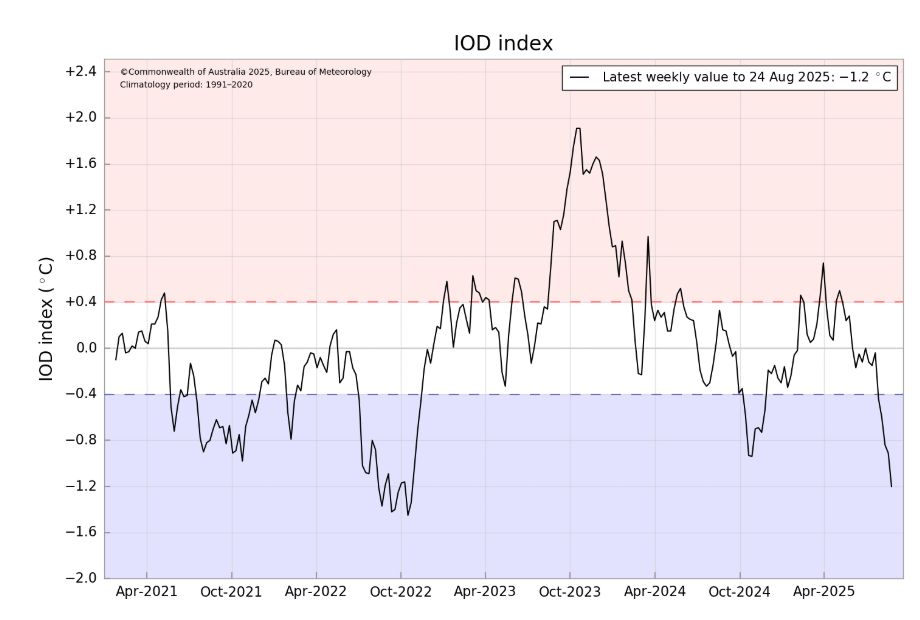
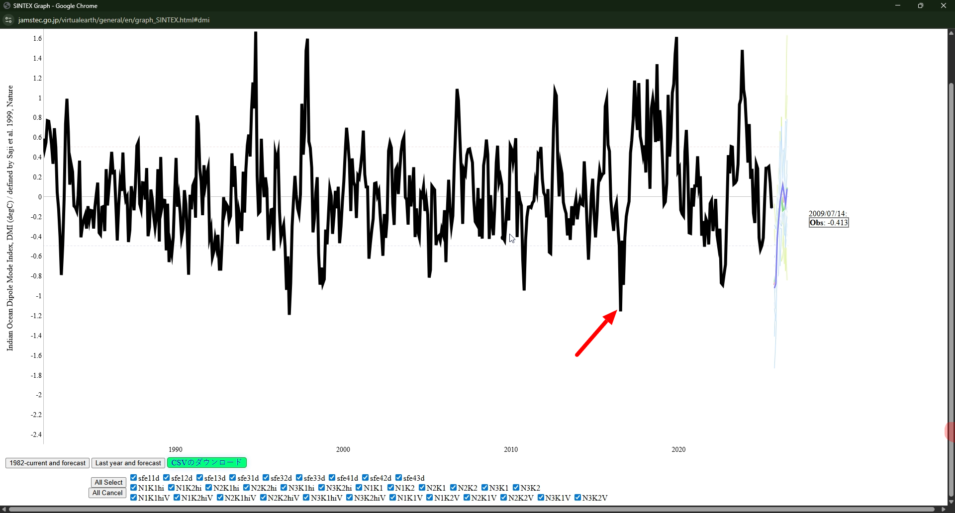
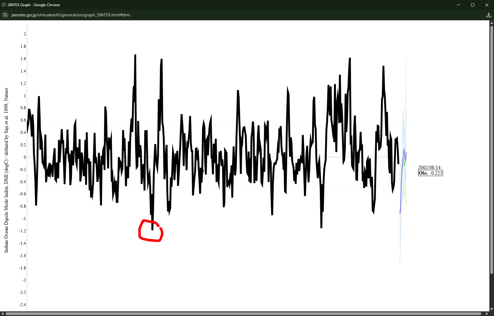
Its still a crap shoot trying to predict the winter.In 1996-97 East Asia was cold and so were we.In 2016-17 winter East Asia was warm and so were we,so you have to see whats actually driving the pattern but otherwise both of these winters i shown were in a NINA pattern,i still believe it could be like last winter,but i can also see what Carver said a few weeks ago being right.This pic i posted with the arrow in the negative IOD which is by contrast was in mid July was -1.5 in 2016,so your extreme negative IOD isnt the total driver. It fascinates me tho about the IOD.When ever you have an an extreme +IOD,in general it leads into a decent NINO the following year but when you have a strong -IOD like now, NINA continues but in case like 1997 evolved into a strong NINO,but in 2017 it was like a resurrgent NINA.oh well,i can get intrigued by strange shit..lol

-
This could be the most negative -IOD We've seen since the early 1980'S.Back into 1996 it dopped to -1.192 on 10-16-96 per JAMSTEC, per the BOM it recently dropped to negative 1.2 I couldnt resist to play around and check out AI on google the winter of 1996-97 in our parts,just take it as a grain of salt,surely dont mean we will repeat AI Overview The 1996-97 winter in Tennessee was marked by a long period of cold and snowy conditions, with some records set for the season, including a major spring snowstorm in March 1997 that added to an already harsh winter, though it was not a particularly severe event in the context of Tennessee history compared to other major events. Records for the winter season were set in other parts of the country, but for the Nashville area, the 1996-97 winter was described as long and harsh. Key characteristics of the 1996-97 winter in Tennessee: Long Duration of Cold: The winter started with cold conditions, and many areas saw snow accumulate starting in November, with the ground remaining covered under snow through February. Spring Snowstorm: A significant storm in March 1997 brought more snow to the region, adding to the heavy accumulation from the winter, which was a long and harsh winter for the region. Overall Severity: The winter of 1996-97 was considered a harsh one, with some areas experiencing extreme winter conditions.

-
I still believe this winter will be kinda similiar to last winter.It should start out warm and wet as the potential for a -IOD as we get into severe fall,early winter.The MJO right now is fixing to creep along the IO the next several days with a potential strong EWB,this abide should strengten NINA upcoming.Our severe season last year was headed into a top record breaking season until that strong Bearing Sea blocking took shape into early spring,this caused the jet to go further north and brought more severe into the OV
.thumb.png.1cd86810af615a880bc726cfe934097c.png)
-
I saw this on the news last evening around yalls parts,that was crazy
-
Sorry to hear this.My prayers are with you and fam,i'm sure this forum will miss him for quite a long time
-
Like to find the weather charts and see this On June 28, 1928...A severe weather outbreak produces 5 tornadoes across Middle Tennessee, beginning on the afternoon of the 28th, and continuing into the next morning. All tornadoes are classified as F2. One person is killed in Davidson County. Another 38 injuries are reported overall.
-
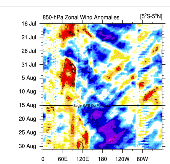
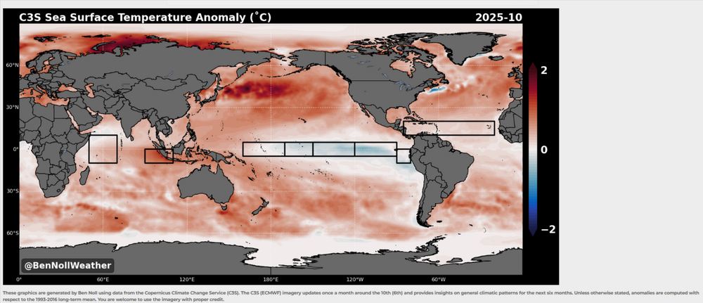
Pattern what CANSIPS is showing right now looks maybe similar to last winter.More NINA, weak NINA.I'm surprised it didnt show more blocking into the Hudson with the blocking its showing into around the four corners,but it still looks like a -NAO.Jan would seemingly right now be BN with the blocking its showing into the Western AK/.Bering Sea.Into Feb this blocking shifts into the Bering Sea,this seemingly could bring a early severe threat Think myself the warm SST'S into the Yellow Sea into the Sea of Japan and off the east coast of Japan are unprecedented to rely on analogs.I mean the warmest SST'S in this region was in 2023 during a strong NINO
-
No clue what happened here other than hail and wind,i thought some of the cells should have been tor warned sooner and a couple that should have been warned that wasnt,but thats just me.I know there was some large hail over 2" in Franklin and other places as well,we just got wind here,i didnt see no hail.I thought Morristown was suppose to do our weather here basically,sure they were busy also.
-
More than likely because they are updating AWIPS this week and couldnt reschedule.They gave the public advance notice because some things might be down at times along with NOAA radio the next few days
-
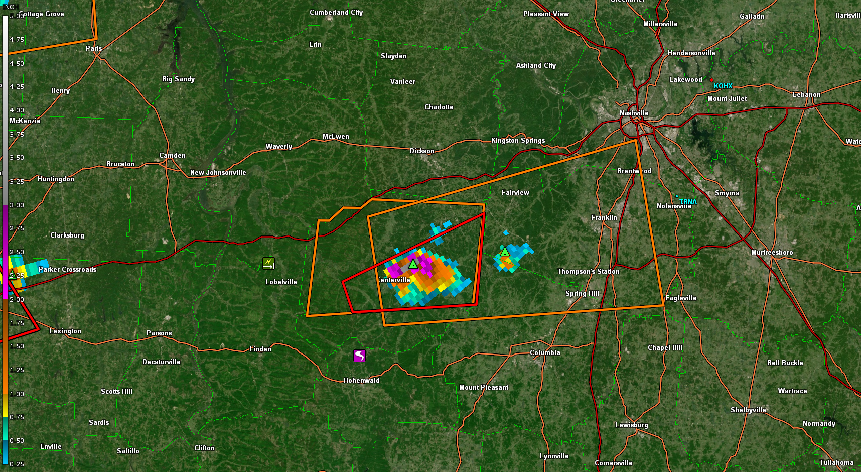
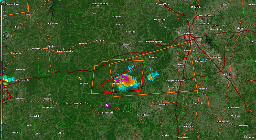
Some big hail ,the Centerville cell
-
Confirmed Tor headed towards maybe Duck River
-
Confirmed Tor headed towards maybe Duck River
-
Could be Monday as well,where ever the boundary sets up.GFS has been showing this for several runs now,but Tuesday looks better as you mentioned ...Portions of the TN Valley... Multiple rounds of thunderstorms are possible along a residual baroclinic boundary across the TN Valley, both during the morning hours, and later in the evening. While not quite as unstable as points farther to the west, modest mid-level lapse rates amid elongated hodographs should support multicells, supercells, and short line segments. The stronger storms may be capable of isolated instances of large hail, gusty winds, and perhaps a brief tornado.
-
That cell is trucking 70mph
-
Be interesting how the ENSO plays out into severe fall.I know some of the NMME'S has been showing a resurgent Nina.But by BN's maps and some of the NMME'S i'd think the GOM could get rather active from June -Aug,thats JMHO. https://www.bennollweather.com/climate-graphics
-
We got some P-sized hail for about 5 min then the non severe winds kicked in.Glad we didn't get 2" variety,i already had to replace two windshields from the winter storms.My wife tried to run the wind shield wiper in which was stuck in her car,it ended up cracking the window all the way across where the both wipers were,daughter poured hot water on the winshield,that didnt work out very well..lol Soon as the ULL gets kicked out around mid week next week it looks fairly unstable for a few days anyways right now..Nashville is already saying it's favorite words.Stay Tuned!!
-
Made it to 86 today,one degree F from tying the record
-
Looks messy everywhere,dont look like no big tor outbreak like twitter is telling the world..lol.Our area for most of us shows piss poor lapse rates no lift,etc.,etc to early to say next?
-
This winter will likely seemingly be warm,its rare to see back to back cold winters in our parts,we had plenty of chances to get a decent snow storm but nooooooooo..it happened down in or around the GOM,in which i feel really annoyed about,they got 2x,3x more snow than what we got here in a day than what we got in the season
-
Really like this set up for us.But we will see,just say there is a chance for now,When you start to see a ridge into Mongolia, ULL headed towards the Koreas and ridge into the Sea of Okhotsk into the Bearing Sea,this is normally severe in our parts,but there will always be some sort of a HP in the East that could very well cut off the moisture flux
-
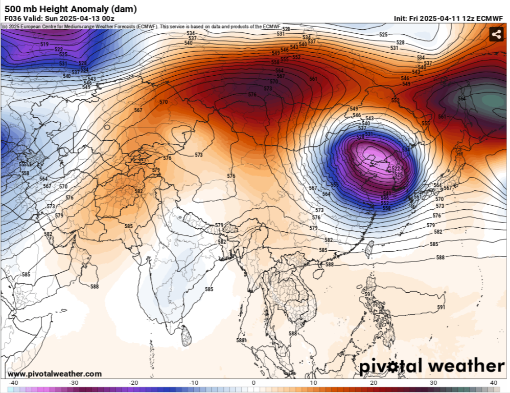
Might be a day or two later but thats not a weak Upper Level Low going through East Asia the next day or two.With heights rising into Mongolia and Japan,i'd be surprised myself if the models dont start showing a more severe threat in the upcoming runs

-
Think we should have a decent chance of severe as we get around the 20-21 of April.Thats a strong ULL coming into from East China into the Koreas next weekend,all the models are showing this with rising heights into Mongolia and Japan,looks kinda meh until then,dont mean you cant get severe just looks meh
-
We had a tornado contest years ago here,I'd always pick Yazoo City in those parts when in storm mode,that town is a tornado magnet..lol
-


.png.ccdc638214d89d85fbd7058775177c73.png)