jaxjagman
-
Posts
9,156 -
Joined
-
Last visited
Content Type
Profiles
Blogs
Forums
American Weather
Media Demo
Store
Gallery
Everything posted by jaxjagman
-

Fall/Winter 2025-26 WX Discussion Thread
jaxjagman replied to Carvers Gap's topic in Tennessee Valley
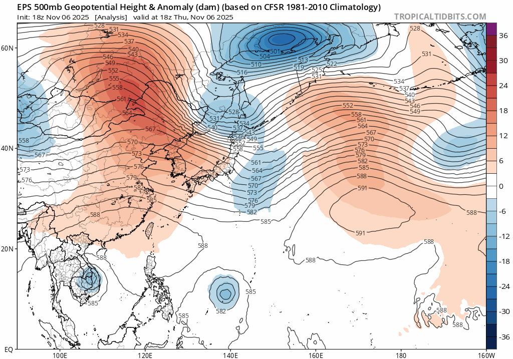
My thinking is later on there will be a phoon headed towards China the next couple days,this will pump up the heights from the Yellow Sea into Japan along with the MJO headed into the WP,so that should be height rises towards Mid Nove for a few days,guess the good news right now is the MJO could possibly go into the COD,but anyways what the EPS seems to be showing today is a trough going thru East Asia round the 15th,so we'd probably be seeing a CF right before thanksgiving and back to BN temps at least for a bit..JMO
-
Thought it would be a more severe thunderstorm not tor watch
-
URGENT - IMMEDIATE BROADCAST REQUESTED Tornado Watch Number 635 NWS Storm Prediction Center Norman OK 325 PM CST Fri Nov 7 2025 The NWS Storm Prediction Center has issued a * Tornado Watch for portions of Northern Alabama South-Central Kentucky Middle into Eastern Tennessee * Effective this Friday afternoon and evening from 325 PM until 1000 PM CST. * Primary threats include... A couple tornadoes possible Scattered damaging wind gusts to 70 mph possible Isolated large hail events to 1.5 inches in diameter possible SUMMARY...Scattered thunderstorms are forecast to develop and intensify through the remainder of the afternoon and persist through much of the evening, as they move west to east across the Watch area. A few of the stronger storms will likely become supercellular and pose a risk for isolated large hail and perhaps a couple of tornadoes. Scattered damaging gusts (60-70 mph) are possible with the stronger storms and may focus with the more organized thunderstorm bands as a mix of linear and cellular storms evolve. The tornado watch area is approximately along and 85 statute miles east and west of a line from 60 miles north northwest of Crossville TN to 40 miles east of Muscle Shoals AL. For a complete depiction of the watch see the associated watch outline update (WOUS64 KWNS WOU5).
-
Looks meh,DP's arent even into the 60s along the Al/TN line,no convection other than 1-40N ATM
-
I was about to post this..lol
-
Fall/Winter 2025-26 WX Discussion Thread
jaxjagman replied to Carvers Gap's topic in Tennessee Valley
Doubt we see any SSWE soon, the Euro shows the winds decelerating some but thats not going to be much to weaken it a whole lot,then shortly after they accererate once again.Its fairly strong right now,well below the modern day era
-
Fall/Winter 2025-26 WX Discussion Thread
jaxjagman replied to Carvers Gap's topic in Tennessee Valley
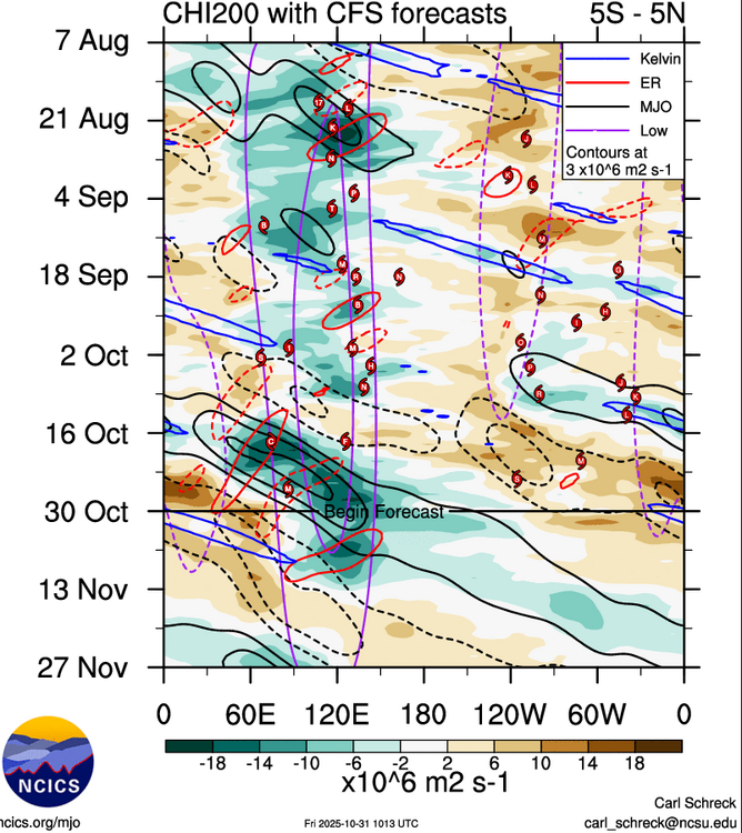
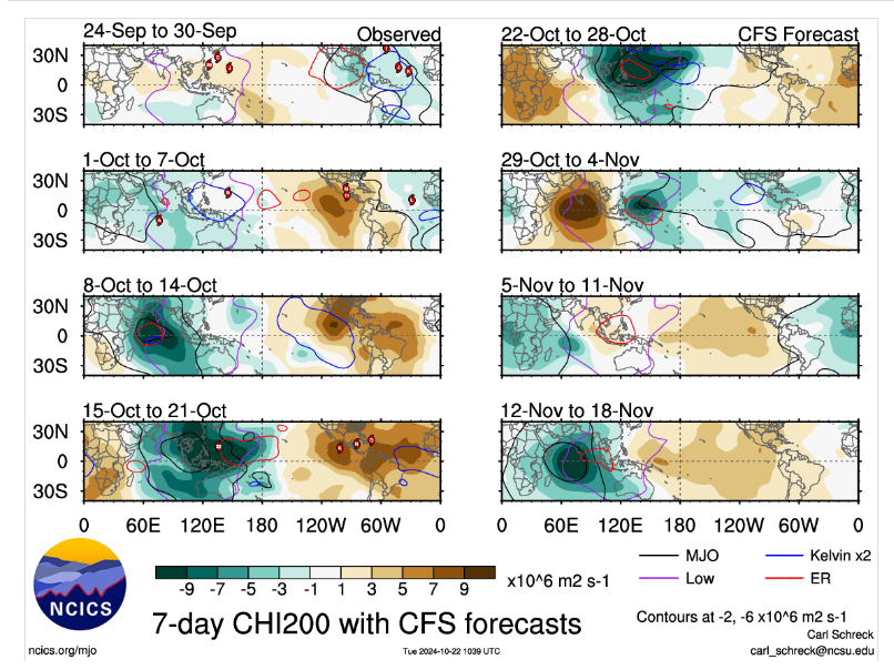
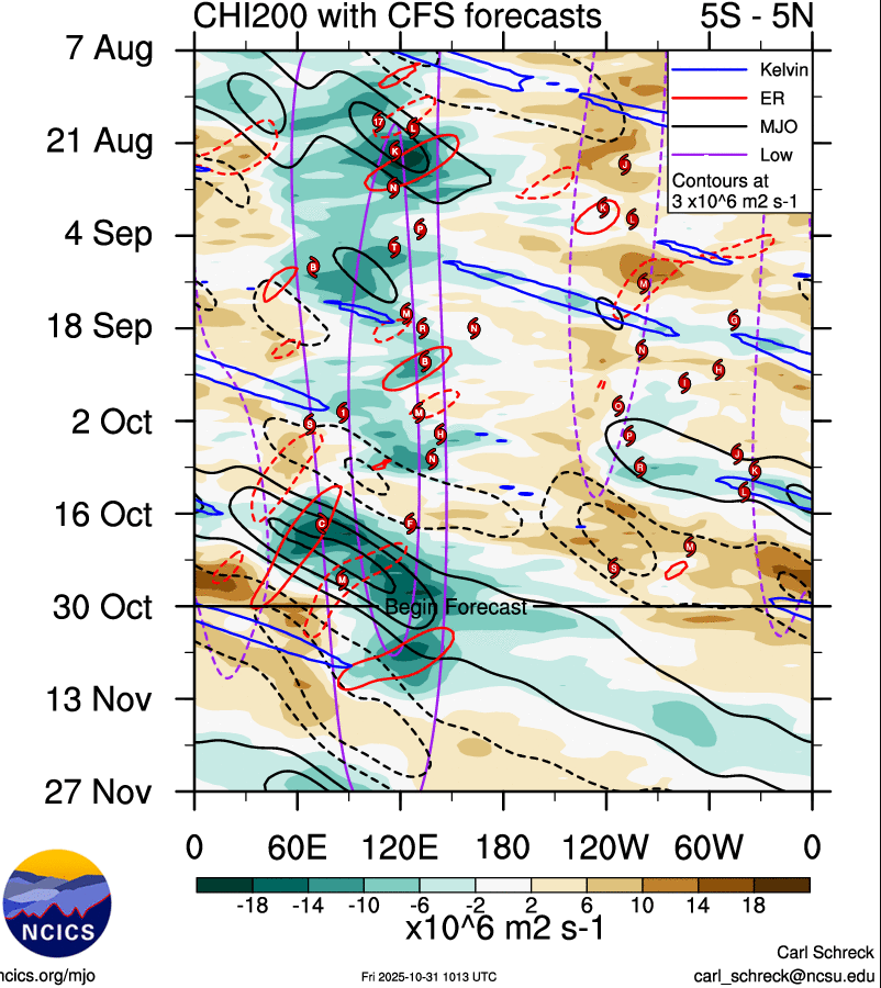
MJO is headed towards the WP in a few days,Euro and JMA seem to be in good agreement it could possibly stay active as it gets into the NH,no clue what it does after that ATM.But this upcoming pattern as we get towards the middle of Nov looks rather bleak for several days,more than likely SER,just make matters worse all the models has a phoon headed towards East China next week -
Fall/Winter Banter - Football, Basketball, Snowball?
jaxjagman replied to John1122's topic in Tennessee Valley
Guess we can say Auburn got Freezed out yesterday -
Fall/Winter 2025-26 WX Discussion Thread
jaxjagman replied to Carvers Gap's topic in Tennessee Valley
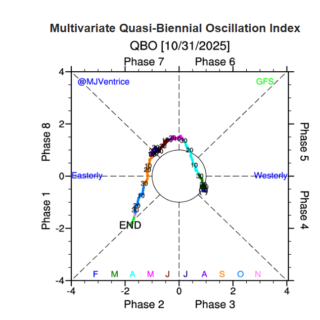
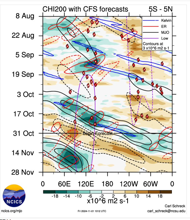
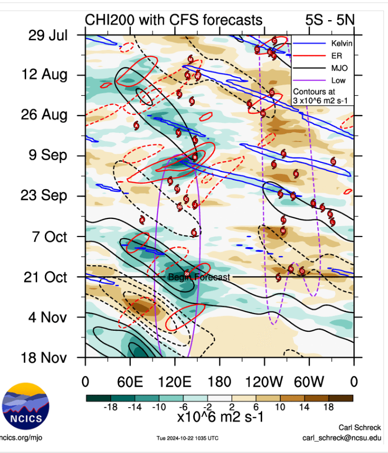
We seem to have a similar pattern as of last year to an extent as of the date today.Most of the models have been into a good agreement recently of the MJO but now are starting to distance themselves recently it seems.Should see what the MJO does upcoming.CFS other than timing right now looks the same AS 2024,posted up top.One difference right now should be the QBO as we was more in a de-amplified QBO but westerly to a amped Easterly.Think the last thing you want to see for a cold Nov is for the MJO to get into the WP,
-
Fall/Winter 2025-26 WX Discussion Thread
jaxjagman replied to Carvers Gap's topic in Tennessee Valley
Thinnk this fall has alot of similarties to last fall as we head into Dec,some teleconnections surley dont match ATM
.thumb.png.66673f448633b3c5cba2254ecccd142b.png)
-
Yeah but you have to read what the author wrote bro,hes talking about from 2008-present and gives a date Sept29 through Oct 5,hes actually right,hes just talking about a certain period to his credit
-
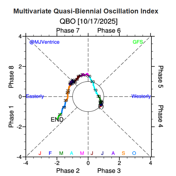
This winter or leading into at least has alot of characteristics of 2024,ENSO,PDO,etc., yeah some teleconnections wont match up mainly the QBO.Be interesting to see how this winter spawns out,seems more than likely a weak PV unlike last winter with a westerly QBO almost into COD sort of speaking Seems to me we probably see a wavy pattern this year with no great analog years.Even the MJO this time of year is similar to last or even possibly into the next few weeks,dunno,we'll see.But the ENSO is quite similar right now. The MJO pic is from last year
-
Fall/Winter 2025-26 WX Discussion Thread
jaxjagman replied to Carvers Gap's topic in Tennessee Valley
Could break the record high Sat around here ahead of the CF,possibly even some severe storms,we could use some rain again here,we've went into a lull lately once again with any liquid -
For a Nina pattern the Gulf of Mexico has been dormant,other than TS Barry hitting the Bay of Campeche in late June there has been notta,that hasnt happened since 1991,You'd think we'd have an active S/Jet this winter,severe/cold,who knows
-
Seen that also today https://www.facebook.com/ChrisJustusWYFF4ChiefMeteorologist/posts/️-attention-snow-lovers-️the-european-seasonal-snow-forecast-is-out-and-while-we/1343397287154418/
-
PDO finally rose some what last month,it was the most negative this summer in July and August since 1854,record breaking months anyways,hopefully the shutdown dont last long so we can see the next update sooner than later https://www.ncei.noaa.gov/pub/data/cmb/ersst/v5/index/ersst.v5.pdo.dat
-
So many objectives to play with this winter.I keep seeing social media seemingly saying this is a slam dunk of 2010-2011,why? I mean you do have the early Siberian snowfall going into Oct which is a plus,BUT at the same time in 2010,had seemingly a strong westerly +QBO,in which would keep possibly the PV strong its what we seen last winter In California which is even more unusual during a Nina had record rainfall in Dec of 2010.Even the -NAO,wemt on record of being the strongest ever recorded since 1825 ?Not sure how records were recorded back then,im not that old..lol
-
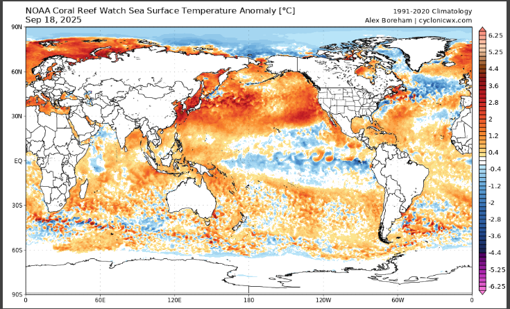
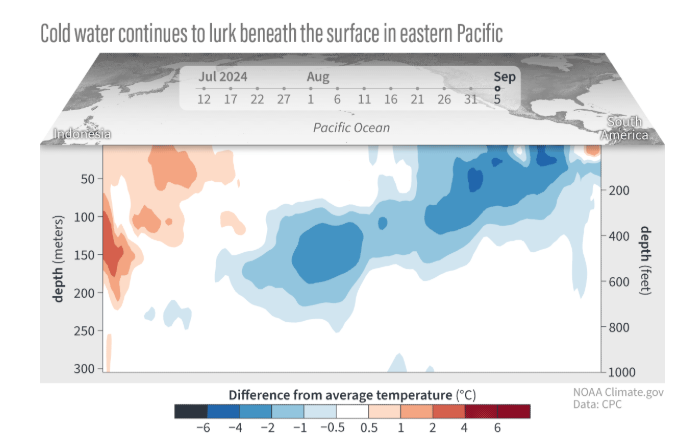
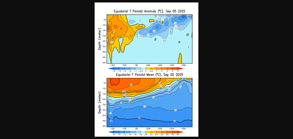
Not really sure how anyone can really come up with a real good analog for this winter anymore.Like Carver mentioned above we have a easterly QBO unlike last year it was more westerly.The SST'S in East Asia are so warm into the Yellow Sea and Sea of Japan,and in August resulted in the warmest month of August ever in South Korea and Japan,it was the hottest in Japan ever since records were taken back into 1898
-
I dunno,dont shoot the messenger,but it seems to be more related to the ENSO,IN 1980 our subforum into NC and the east coast would be saying bring it on,maybe a coincidence,i have know clue,planetary waves can take weeks if not months to have effects in NA, but both of these years i stated above seem to be more of developing ELNino,not NINA with a SWE in the SP https://www.weather.gov/mhx/Mar011980EventReview
-
Think more study should be looked at.SSWE are rare to start with in the SP,since last year there never has been one since 2002,its even more rare last year there were two.But there is also seemingly some correlation with ELNino and LaNIna,in 1979 and the last SSWE in 2002,these were ELNINO years,.2003 winter had the great blizzard in the Mid Atlantic/NE,late JanBut i still think these planetary waves,Rossby,etc,etc in the NP would be hard to predict from what happens in the SP
-
https://agupubs.onlinelibrary.wiley.com/doi/full/10.1029/2025GL115257 There were a couple last year,but i have no clue how it effects planetary waves between the NP and SP,that would be a question for our scientist
-
https://www.cpc.ncep.noaa.gov/data/indices/RONI.ascii.txt Enso is about similar this year as it was last year,to this date anyways
-
Fall/Winter Banter - Football, Basketball, Snowball?
jaxjagman replied to John1122's topic in Tennessee Valley
First time ive heard of this folklore,Its the talk of some people in Lawrence Co.They got 2-spoons and of knife How to make a persimmon seed prediction Split the seed: Carefully cut the seed in half lengthwise with a sharp knife. Observe the shape: Look for one of three symbols within the seed's white inner structure (cotyledon): Fork: Indicates a mild winter. Spoon: Signifies a lot of snow that will require a shovel. Knife: Suggests a cold, harsh winter with biting winds. Find a ripe persimmon: The fruit should be soft and wrinkled when ready. Extract the seeds: Wash the seeds to remove any pulp.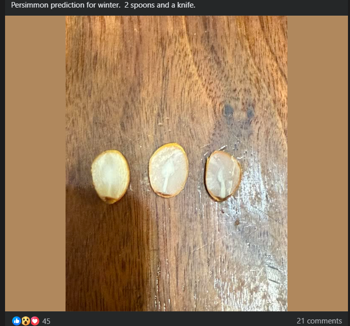
-
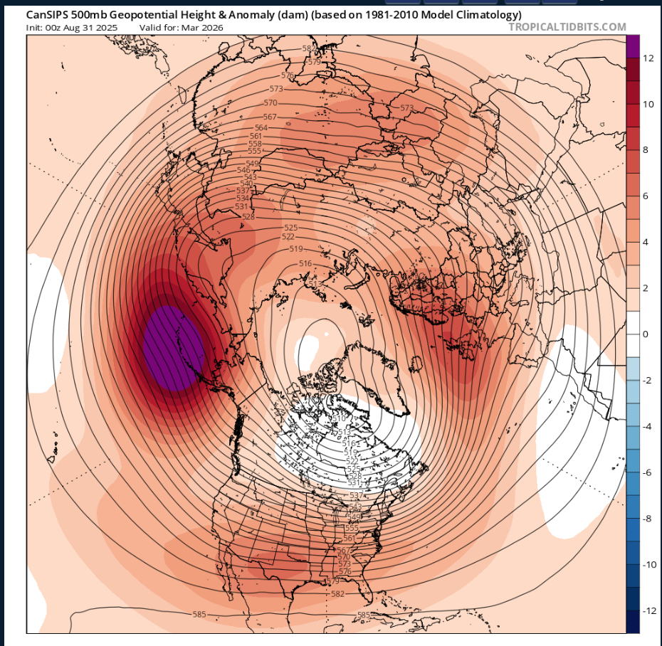
To bad this is CANSIPS this far out,its actually similar to last year to an extent anyways,but this would be nice with an active jet tapping into the GOM,with a -NAO with that Aluetian LOW

-
Some intense convection in SW TN earlier,seen this on GOES


.png.59306d190164721dea99ba0f891aee0c.png)