jaxjagman
-
Posts
9,165 -
Joined
-
Last visited
Content Type
Profiles
Blogs
Forums
American Weather
Media Demo
Store
Gallery
Everything posted by jaxjagman
-
Thats what it seems like to me anyways

-
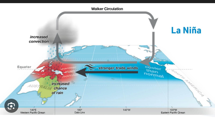
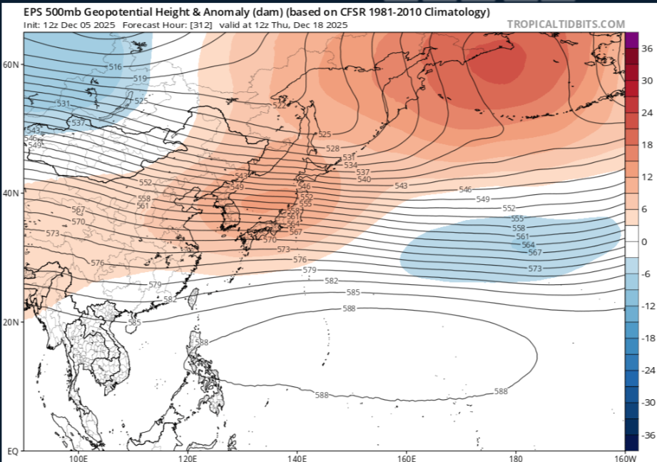
It might be with the Walker Circulation starts to strenghten,this is why you see the ensembles pull the JS much further north and basically traps the cold air up North in the long range in a NINA
-

December 2025 Short/Medium Range Forecast Thread
jaxjagman replied to John1122's topic in Tennessee Valley
I mean basically this is what we are seeing if you look towards Eastern Aussie land,not saying we will torch but its not gonna get that cold,cold air is gonna be trapped in Canada,Upper Plains.thumb.gif.1f7dee41e2c9a7f456fa10c724457ed2.gif)
-
December 2025 Short/Medium Range Forecast Thread
jaxjagman replied to John1122's topic in Tennessee Valley
It dont look very cold cold to me in the long range,this is in part due to the Walker Circulation ,when you see these strong EWB'S this strenghtens the Walker circulation and pushes the Jet Steam the jet more Northward in winter time during LaNina,in summer time we can see droughts in our parts,which is what we seen this summer,this is what you seem to be seeing right now with the ensembles long range
-
December 2025 Short/Medium Range Forecast Thread
jaxjagman replied to John1122's topic in Tennessee Valley
Record low on Deb 14 in Nashville was 6 degrees back into 1917,so that would break our record if it were to be correct -
December 2025 Short/Medium Range Forecast Thread
jaxjagman replied to John1122's topic in Tennessee Valley
Sure looks like the MJO is getting into the IO/Maritime No doubt about that,,big Artic High moving down from the Upper Plains -
December 2025 Short/Medium Range Forecast Thread
jaxjagman replied to John1122's topic in Tennessee Valley
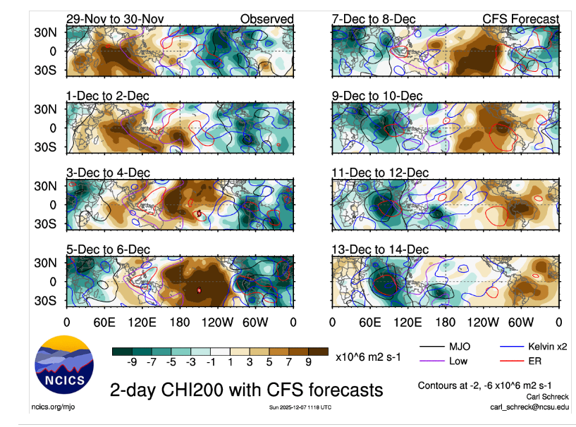
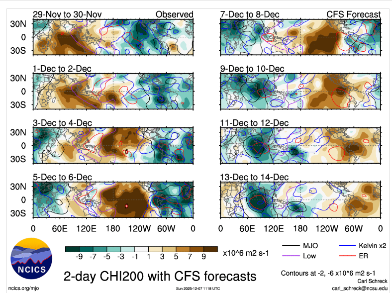
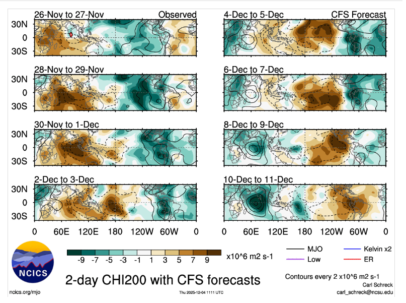
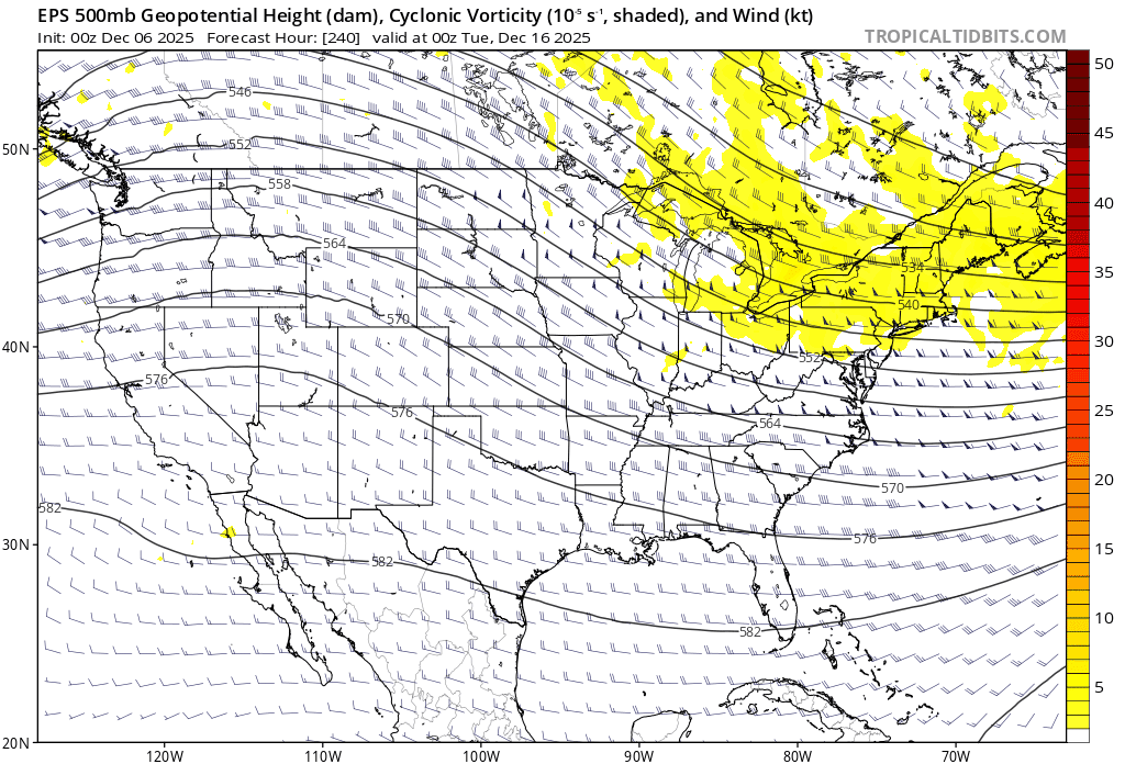
Ensembles are going Zonal in the long range,not a warm look but its not cold either,very little QPFS,probably the only hope would be a bowling ball if it could manifest any cold with it I'm starting to wonder if the CFS is more right with the RMM'S,its been showing it going into WP the last several days,now its showing another Kelvin,Rossby into the WP towards the end of the year and crapping out there,we'll see if it keeps showing this.
-
December 2025 Short/Medium Range Forecast Thread
jaxjagman replied to John1122's topic in Tennessee Valley
Congrats bro !! -
December 2025 Short/Medium Range Forecast Thread
jaxjagman replied to John1122's topic in Tennessee Valley
But you should see a definite warm up past the Mid of Dec,probably not brutal but AN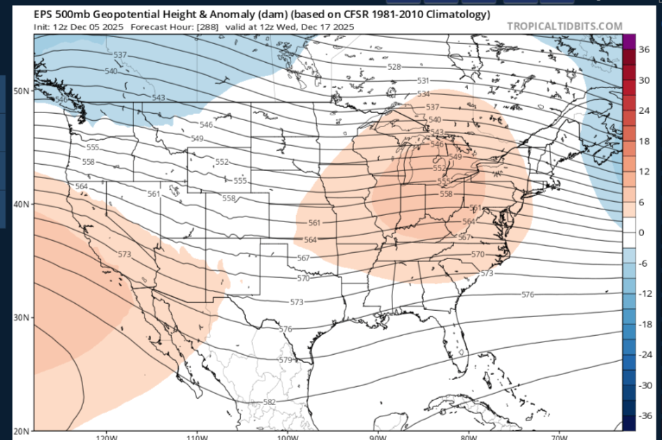
-
December 2025 Short/Medium Range Forecast Thread
jaxjagman replied to John1122's topic in Tennessee Valley
Ill use what the EPS shows,as heights rise into East China/Koreas this should be a warming in the east,BUT during this time the blocking along the Aluetians get shifted into Siberia,this would cause height falls into East Asia,i really think we will have a cold X-Mas,plus the MJO into which seems TO to be maybe in Africa right now maybe or at least western IO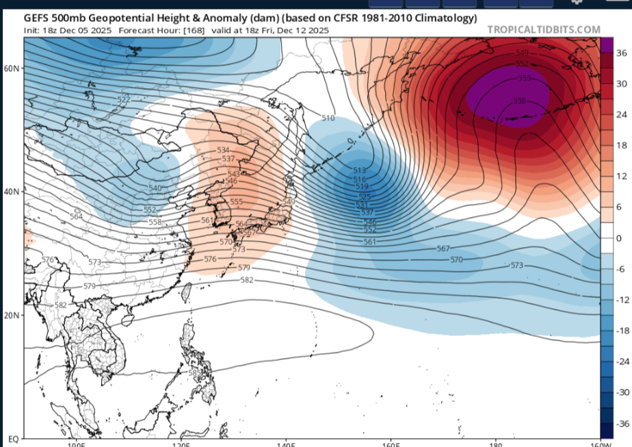
-
December 2025 Short/Medium Range Forecast Thread
jaxjagman replied to John1122's topic in Tennessee Valley
Be a good case study upcoming in general cause around the 23rd of Nov the SOI dropped,and took out the Nina base state but rose shortly afterwards back towards NINA,so you'd have BN temps towards the middle of Dec but this would be transient because afterwards a few days the SOI would rise again.But the large fall the last few days would tell you it could get rather cold right before X-Mas unlike some of what the models seemingly show,but other teleconnections still play apart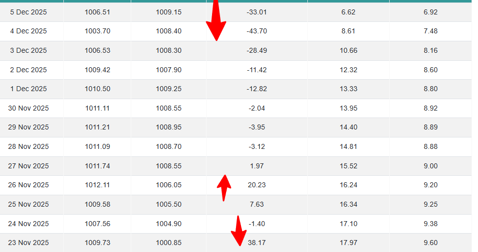
-
December 2025 Short/Medium Range Forecast Thread
jaxjagman replied to John1122's topic in Tennessee Valley
Strong blocking into the Western Aluetians,Bearing Sea being shown would pump up a +PNA but where does the Trough Axis set up,definite cold look towards the Mid month
-
December 2025 Short/Medium Range Forecast Thread
jaxjagman replied to John1122's topic in Tennessee Valley
Not sure the MJO is really stalling out,its during the next few days the signal is getting nothing but constructive interference from Kelvin.Rossby.CFS has been showing this for several days now.thumb.png.fadd28caa8e452c88b568fbb634ce528.png)
-
December 4th through 5th 2025
jaxjagman replied to Holston_River_Rambler's topic in Tennessee Valley
Nothing but rain here,gonna be over by the looks pretty soon,back edge is closing in -
December 2025 Short/Medium Range Forecast Thread
jaxjagman replied to John1122's topic in Tennessee Valley
Keep seeing it being to warm while the clown maps keep saying you'll get IP and SN,looks more cold rain here -
December 2025 Short/Medium Range Forecast Thread
jaxjagman replied to John1122's topic in Tennessee Valley
Look at the SOI around the 23 of Nov then next week,this is when the models get chaotic with the MJO,but even that today, look how negative the SOI is today,the LaNina base state has been taking out and it is acting more Nino now,seems like the JMA and Euro are going into the COD,then back into the WH afterwards possibly and should probably climb back out the COD,actually the GEFS isnt far behind.png.7ad43df83999243f6419d681cee62440.png)
-
December 2025 Short/Medium Range Forecast Thread
jaxjagman replied to John1122's topic in Tennessee Valley
lol...glad i'm not the Met at OHX -
Fall/Winter 2025-26 WX Discussion Thread
jaxjagman replied to Carvers Gap's topic in Tennessee Valley
Per OHX,we are right now today+3.2 AN,Nov isnt a dry month either here and we are below avg 1.76" https://forecast.weather.gov/product.php?site=BRO&product=CF6&issuedby=BNA -
December 2025 Short/Medium Range Forecast Thread
jaxjagman replied to John1122's topic in Tennessee Valley
Euro Mean today,i still think you stick with the JMA right now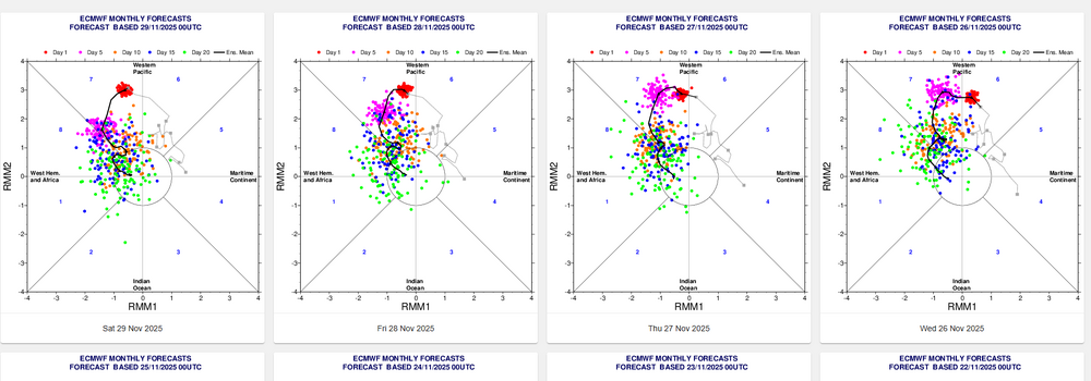
-
December 2025 Short/Medium Range Forecast Thread
jaxjagman replied to John1122's topic in Tennessee Valley
Its just my opinion but when the SOI dropped pretty good around the 23rd then rose before Thanksgiving and the dropped again after,this pattern could should more than likely look like this into East Asis into the first week of Dec,it wouldnt effect our weather until right before the mid month of Dec 29 Nov 2025 1011.21 1008.95 -3.95 14.40 8.89 28 Nov 2025 1011.09 1008.70 -3.12 14.81 8.88 27 Nov 2025 1011.74 1008.55 1.97 15.52 9.00 26 Nov 2025 1012.11 1006.05 20.23 16.24 9.20 25 Nov 2025 1009.58 1005.50 7.63 16.34 9.25 24 Nov 2025 1007.56 1004.90 -1.40 17.10 9.38 23 Nov 2025 1009.73 1000.85 38.17 17.97 9.60 22 Nov 2025 1011.59 1003.75 31.56 17.51 9.41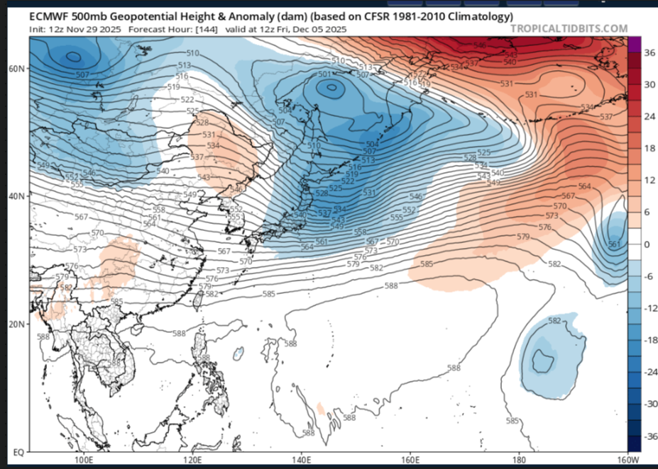
-
December 2025 Short/Medium Range Forecast Thread
jaxjagman replied to John1122's topic in Tennessee Valley
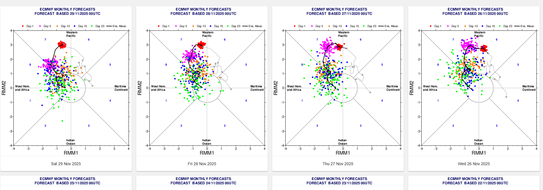
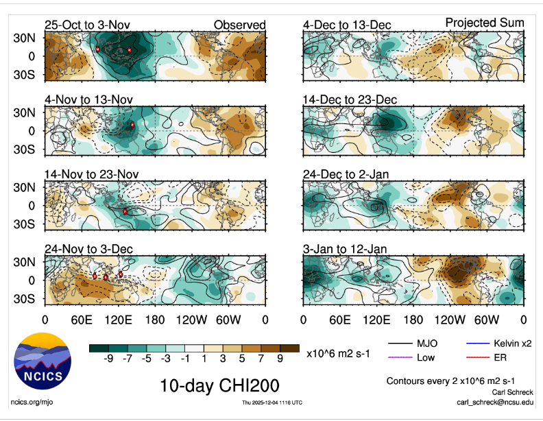
IMHO out in the Pac there is alot of stuff going on with Rossby and Kelvin waves,this is why all the models seem to be struggling with the RMM,even the JMA which has been more tightly bunched is now showing more spread today.You'll more than likely in the next few days see some swings in modeling
-
December 2025 Short/Medium Range Forecast Thread
jaxjagman replied to John1122's topic in Tennessee Valley
Few days ago it was showing a WWB east of the IDL,where did it go..lol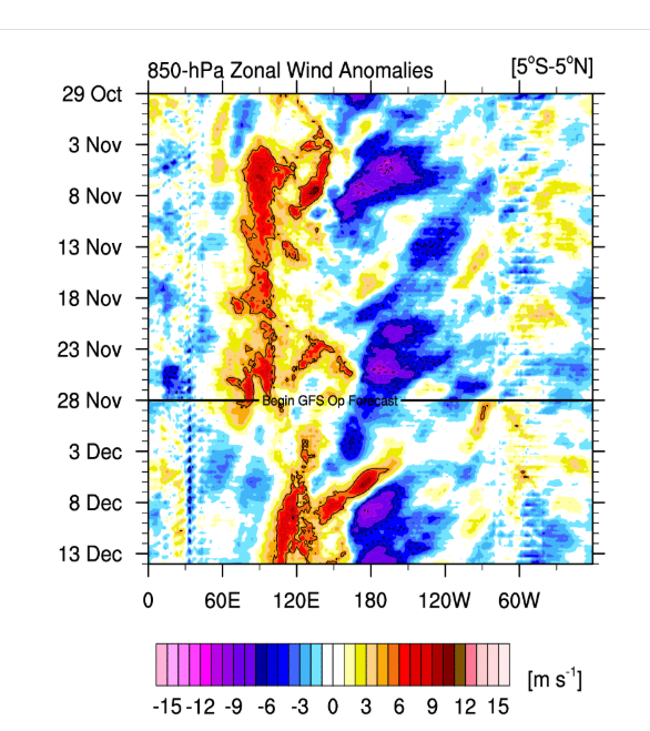
-
December 2025 Short/Medium Range Forecast Thread
jaxjagman replied to John1122's topic in Tennessee Valley
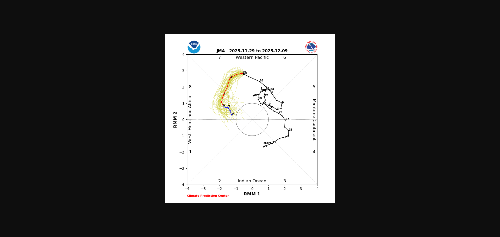
No words needed where the MJO is today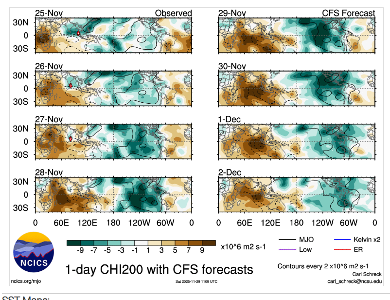
-
December 2025 Short/Medium Range Forecast Thread
jaxjagman replied to John1122's topic in Tennessee Valley
We always here in Middle Tn get hosed by inverted troughs,still remember when we had a Winter Storm Warning that was right before the snow dome talk came in,was suppose to get 3-5" and the models missed the inverted trough and we just got rain instead,because it missed the warm nose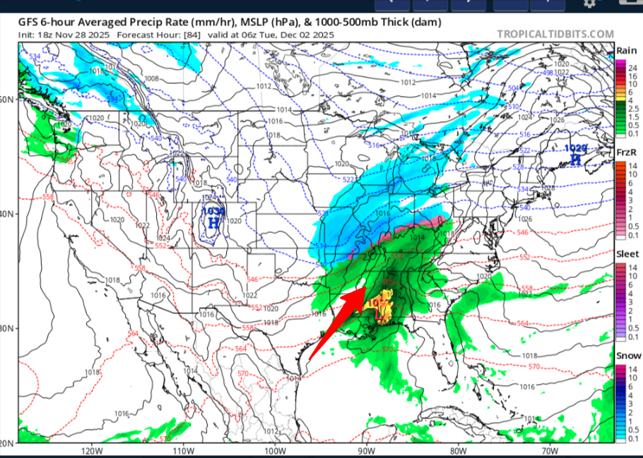
-
December 2025 Short/Medium Range Forecast Thread
jaxjagman replied to John1122's topic in Tennessee Valley
.gif.469c76a92091bafca7a10cb6e4bf2c4e.gif)


.png.12b676c57d67be23ef3ab863c8872311.png)