jaxjagman
-
Posts
9,156 -
Joined
-
Last visited
Content Type
Profiles
Blogs
Forums
American Weather
Media Demo
Store
Gallery
Everything posted by jaxjagman
-
Be watching Auburn so im staying home.Some of the latest Mesoscales look better south of Memphis about 50-75 miles give or take,thats around mid afternoon,it dont look bad even where you are at later
-
I went to bed about 11AM Wed night before the storms here came trough and it was still 81.Today here we made it to 87 high,Nashville OBS says it was 86 so it missed the record of 87 in 1934
-
Big HAIL
-
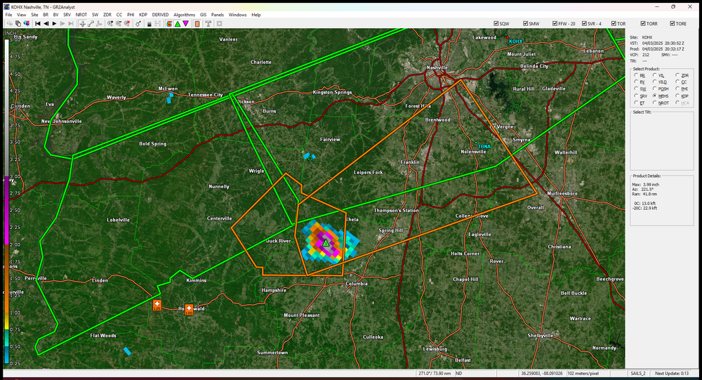
NROT IS UP TO 2 now that cell headed towards Thompsons Station
-
That sure look like a tornado to me..lol
-
Centerville is showing rotation also now
-
Finally seeing rotation now
-
Big hail from Holenwald cell ,marker has 4.29"
-
Tor emergency now
-
over Lake City now
-
2,5 now on NROT
-
Looks like a large tor over Bay ,Ark,NROT is showing a 2.0 and its a confirmed cell
-
URGENT - IMMEDIATE BROADCAST REQUESTED Tornado Watch Number 98 NWS Storm Prediction Center Norman OK 250 PM CDT Wed Apr 2 2025 The NWS Storm Prediction Center has issued a * Tornado Watch for portions of Eastern and South-Central Arkansas Southern Illinois Southwest Indiana Western Kentucky Southeast Missouri Northern Mississippi Western Tennessee * Effective this Wednesday afternoon from 250 PM until Midnight CDT. ...THIS IS A PARTICULARLY DANGEROUS SITUATION... * Primary threats include... Several tornadoes and a few intense tornadoes likely Widespread damaging winds and isolated significant gusts to 80 mph likely Scattered large hail and isolated very large hail events to 2 inches in diameter possible SUMMARY...Storms are expected to develop this afternoon initially across the ArkLaMiss and Mid-South, with the overall environment becoming increasingly favorable for tornadoes through late afternoon into early/mid-evening. Some of these tornadoes may be strong or intense (EF3+), with widespread damaging winds also likely across the region by evening. This is a Particularly Dangerous Situation with intense storms expected over a relatively broad regional area, with multiple rounds of severe storms possible in some areas. The tornado watch area is approximately along and 90 statute miles east and west of a line from 55 miles southeast of Pine Bluff AR to 30 miles northwest of Evansville IN. For a complete depiction of the watch see the associated watch outline update (WOUS64 KWNS WOU8).
-
Stuck in town.Wife is working out of town tomorrow and her mom has a doc appt, i have to take her
-
US National Weather Service Nashville Tennessee *** 5:29 p.m. update: We have also confirmed an EF-1 tornado (95 mph winds) touched down in McEwen/Humphreys County (150 yards wide/1.7 miles long). We may be surveying additional damage sites tomorrow. *** We have so far confirmed 3 tornadoes in Middle Tennessee resulting from last night's storms. This is preliminary information, but we can tell you that an EF-2 tornado (120 mph winds) touched down in Hampshire/Maury County (400 yards wide, 5.1 miles long). An EF-1 tornado (100 mph winds) touched down in Mt. Pleasant/Maury County (300 yards wide, 4.1 miles long). And an EF-0 tornado (85 mph winds) touched down in Fairview along the Hickman/Williamson County line (150 yards wide, 2.2 miles long). We are currently surveying one more damage site, so there may be a 4th confirmed tornado.
-
A tor warned cell here,no tor, hail,wind and one of the best light shows ive seen in years
-
Tornado hit McEwen,damage reports coming in
-
Hopefully Auburn plays like they did into the 2nd half against Michigan,that first half was brutal trying to be cute with the b-ball,so many turnovers.Staying home drinking beer and watching Auburn and probably yelling at my TV and listening to my wife saying hush
-
Biggest threat still looks to be to our west,but yeah we could get some healthy rains
-
-
Cutting jobs at the NWS,its really sad how bad these models will become than they already are.I really think hes hoping for a weather disaster and he will come out and say"This is why we need AI technology" and blame the NWS.I know we arent suppose to talk politics and i wont say no more.I cant imagine what emotions you guys as mets are going through right now,i'm sure it's not good and healthy.But i'm really glad to have you mets posting here,its like going to school once again i learn for you guys.So thanks !!
-
Might be best to see what the mesoscales shows tomorrow afternoon.Next week has a chance but the boundary might be the bigger deal with some convective training cells could cause some major hydro issues,where thats at who knows but right now the Euro and GFS shows NW/TN to Ky
-
Day 3 Convective Outlook NWS Storm Prediction Center Norman OK 0231 PM CDT Fri Mar 28 2025 Valid 301200Z - 311200Z ...THERE IS AN ENHANCED RISK OF SEVERE THUNDERSTORMS FOR MUCH OF THE OHIO VALLEY INTO THE MID-SOUTH... ...SUMMARY... A widespread/substantial severe-weather episode is forecast across an area centered on the Ohio/Mid and Lower Mississippi/Lower Missouri/Tennessee River Valleys. Very large hail, damaging winds, and strong tornadoes are expected. ...Synopsis... A somewhat broad upper-level trough with nebulous structure will move from the Plains into the Upper Midwest on Sunday. An embedded shortwave trough will amplify within the broader trough. A surface low will move from Iowa into the Great Lakes region. A cold front will move southeastward into areas east of the Mississippi while dryline will be present in East Texas. ...Upper Midwest/Ohio Valley... Models indicate some potential for early morning thunderstorm activity. This activity will likely be tied to the surface low/low-level warm advection. Some severe risk may accompany these storms. The question then becomes how this activity will impact destabilization across parts of Illinois into Indiana/western Ohio. Wind fields will still support supercells capable of all hazards, but the overall magnitude of these threats will depend on the degree of surface heating that occurs. Much of the Ohio Valley vicinity itself appears that it will not be impacted directly by early morning convection. This will be a zone where a favorable overlap of surface heating and stronger low-level wind fields will exist. Though the cold front will be the initiating boundary, effective shear vectors are expected to be orthogonal to it. This should increase the potential for discrete storms and strong tornadoes in addition to large hail and severe gusts. ...Mid-South... Ahead of the southeastward moving cold front, dewpoints are expected to rise to the mid to potentially the upper 60s (the NAM being typically more aggressive in this regard). Given the presence of an elevated mixed layer, this region is expected to have little to no thunderstorms expected during the morning/early afternoon. Surface heating and increasing mid-level ascent should eventually erode the cap and allow storms to develop by mid/late afternoon. There is some indication that a pre-frontal trough/confluence zone may set up. Should this occur, the potential for discrete storms would increase along with the potential for a more concerning tornado risk. Low-level wind fields will likely be somewhat weaker in these areas given the southward displacement from the surface low. However, forecast soundings suggest low-level hodograph curvature will be more than sufficient, particularly beyond early evening. Even without pre-frontal discrete development, the greater surface heating expected in this region should allow for widespread severe storms along the cold front with a threat for large hail, widespread damaging winds, and QLCS tornadoes. ...East Texas/Sabine Valley... A dryline feature will serve as the focus for convection. Storms in this area would more than likely be discrete. Steep mid-level lapse rates and sufficient effective shear should promote supercells capable of large/very-large hail as well as severe gusts and tornadoes. Later in the period, the cold front will surge south and lead to upscale growth of what activity is ongoing at that time. ..Wendt.. 03/28/2025
-
I wouldnt be surprised to see a upgrade from enhanced in the Mid South and surrounding areas the next update if not tonight,still looks murky in our parts but better today some what
-
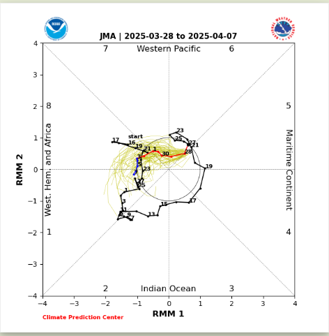
Keep watching the MJO as we get into April.Into the first week of April there looks to be a ERW into the WH and a KW that collides with it moving from the Easterm Pac the next few days.this seemingly should strenghten the MJO signal into the WH,really believe you run with the JMA at this time