-
Posts
9,076 -
Joined
-
Last visited
Content Type
Profiles
Blogs
Forums
American Weather
Media Demo
Store
Gallery
Everything posted by jaxjagman
-
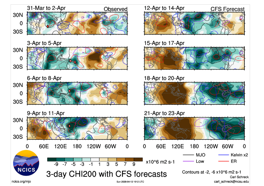
We havent seen this in quite some time,while the CFS can overdue the MJO for certain,its been fairly consistent,either way its gonna knock off that pesky Mid Atl ridge,we have some wiggle room anyways as we head into the 3rd week of April,the typhooon is another story tho,its recurving to far east offf of Japan and building heights from East China through the Sea of Japan,you're probably gonna see ridge building back in the east down the road, rather see the storm going though,Korea or for the matter China
-
Oh i agree with you,but at least we are seeing the tropical convection getting displaced in the upcoming days,we havent seen this in quite some time,which seems to be by a Rossby Wave in the EP and not WP
-
Maybe we'll get a big snow into our area this upcoming winter,Nino does fairly well with Moderate to strong Ninos,they always produce,but the winter in whole should be AN temps,typically Dec should be fairly warm.
-
LOL @ Jeff,you know i was thinking the same thing a couple days ago,that damn MS River,but its the SER like you said,convection into our parts stops west of the River,im still kinda surprised a good chunk of ARK is worse off than we are in TN with the drought Nothing eye popping the next week,some parts should flirt with record temps upcoming the next few days. But there is light at the end of the tunnel,a pattern change is upcoming seemingly ATM The MJO should strenghten into the WH as it looks like Rossby/Kelvin waves interact with each other to strenghten the MJO signal sorta speaking as it heads into Africa
-

2026-2027 El Nino
jaxjagman replied to Stormchaserchuck1's topic in Weather Forecasting and Discussion
There was a WB back into 2023 around the same time from a Rossby Wave.There was also another RW in Mid May JAMSTEC Mean shows the DMI rising into fall almost to +1.5 ATM,but when the DMI rises like this ,this is typical the norm you see more or less NINA the following year,least it's been like this the last several decades -
2015? We had a ice storm that winter,severe was literally non-existent which that year proceeded into a strong NINO later in 2015. Who knows,snowstorm in Jan 2016?That was the most snow we got here in decades.Seems like the potential flooding of Pac air this winter upcoming,AN temps should be the main course
-
Think it could get active as we get into April for a bit.The problem with the MJO is the ERW in which caused twin cyclones and has caused social media hysteria like its never happened before from a ERW.But this is from the Coriolis effect,which makes storms on both sides of the equator and move east to west Its like living the Polar Vortex again since what,OVER decade ago?But this has happened since at least the dinosaur era and beyond ?..LOL I dunno,seems like to me the MJO has been back into Africa the last few days,its caused lots of deaths in that region and the MJO signal is getting totally destroyed by this ERW,could just as well be the transition into NINO
-

2026-2027 El Nino
jaxjagman replied to Stormchaserchuck1's topic in Weather Forecasting and Discussion
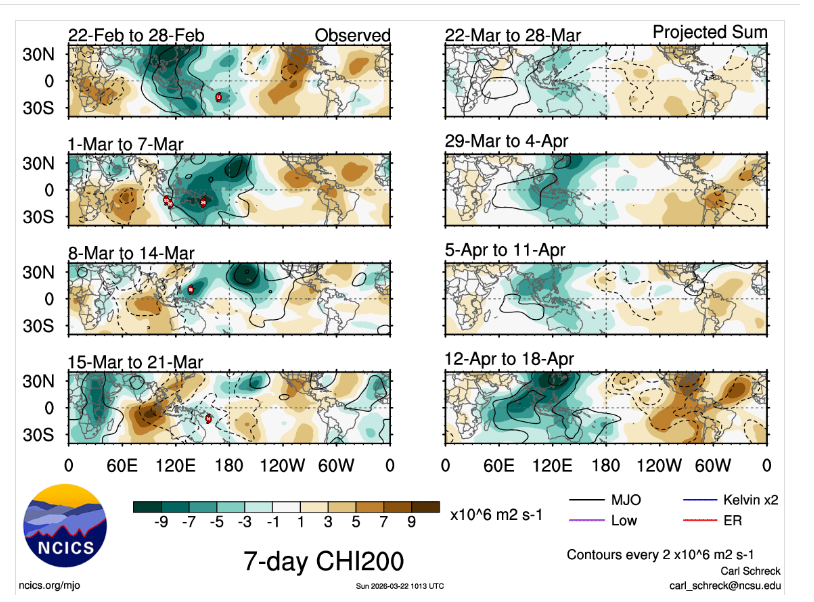
Some of these models especially the CFS has this for whatever reason are to amped when the Rossby Wave Train moves into the WP/MC.You dont seem to see these wind burst even pan out very well.The RMMS today seems to show this Rossby Wave further west than what they have been showing recently as some now show the MJO go back into the WP.It seems possible to me this Rossby Wave could strenghten the MJO signal into the Maritime/IO as we get into April -
See what happens down the road with the MJO CFS has this big bias with Rossby Waves and always over amps them into the WP which causes constructive/destructive interference with the MJO signal,i think this is what you are seeing with this wind burst upcoming west of the IDL. As this Rossby Wave moves into the WP you could see the MJO go back into the WP,this seems like what the RMMS are hinting at, but shortly after the MJO could move fast into the IO after and even strenghten into the IO This is just my thinking ATM and surely could be wrong
-
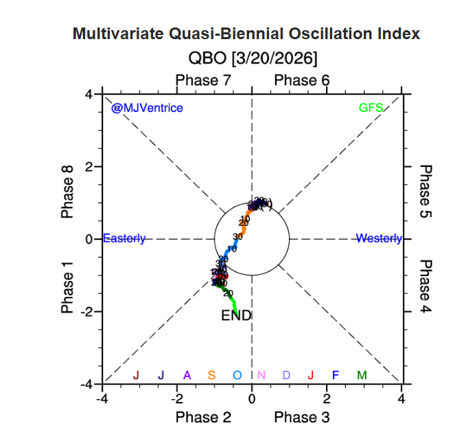
Looks like after being bottled up for a spell next winter we are headed back into a EQBO,potential for a rock PV
- 174 replies
-
- 2
-

-
- severe
- mountain snow
-
(and 1 more)
Tagged with:
-

2026-2027 El Nino
jaxjagman replied to Stormchaserchuck1's topic in Weather Forecasting and Discussion
This looks to be a fairly potent ERW,this could also lead into destructive interference with the MJO signal down the road if the wind burst isnt as strong being shown,but quite a few RMMS arent backing down with the MJO flaking out into the WH -
Public Information Statement National Weather Service Nashville TN 512 PM CDT Tue Mar 17 2026 ...NWS Damage Survey for 03/15/2026 Tornado Event - Update #4... .Update...Date/time correction. .Overview...Middle Tennessee was impacted by a strong storm system that brought widespread strong to severe thunderstorms during the evening and overnight hours of March 15, 2026. Storms produced damaging straight-line winds, isolated large hail, and three tornadoes. Strong non-thunderstorm wind gusts also occurred during that afternoon. A sharp cold front led to a drastic drop in temperatures the morning of March 16 which also brought accumulating snowfall to the Cumberland Plateau. ..Ft. Campbell EF0... Rating: EF0 Estimated Peak Wind: 75 mph Path Length /statute/: 5.05 miles Path Width /maximum/: 200 yards Fatalities: 0 Injuries: 0 Start Date: 03/15/2026 Start Time: 09:35 PM CDT Start Location: 4 SSE Fort Campbell North / Montgomery County / KY Start Lat/Lon: 36.5999 / -87.4486 End Date: 03/15/2026 End Time: 09:40 PM CDT End Location: 3 ESE Oak Grove / Montgomery County / KY End Lat/Lon: 36.6407 / -87.378 Survey Summary: A weak tornado impacted portions of Clarksville. The tornado began in a neighborhood on Fort Campbell. Damage consisted of shingles off the roofs as well as some small tree limbs snapped. The tornado continued east toward Highway 41, where an overhang structure was blown down at a car wash. The tornado then moved northeast through additional neighborhoods and across Outlaw Airfield. Damage in the neighborhoods included rotten trees downed, tree branches snapped, downed fences, shingles blown off roofs, and occasional vinyl siding and metal metal fascia. The tornado crossed Outlaw Field and uprooted a few trees on a farm just northeast of the airfield. The tornado then continued northeast into a large residential neighborhood causing additional minor structural and roof damage to several homes and snapping small tree limbs. The tornado dissipated somewhere near the TN/KY state line in an open field south of Interstate 24 as no additional damage was found north of Allen Rd. ..Mt. Pleasant/Columbia EF1... Rating: EF1 Estimated Peak Wind: 90 mph Path Length /statute/: 16.53 miles Path Width /maximum/: 500 yards Fatalities: 0 Injuries: 0 Start Date: 03/15/2026 Start Time: 10:06 PM CDT Start Location: 1 NNE Mount Pleasant / Maury County / TN Start Lat/Lon: 35.5591 / -87.1848 End Date: 03/15/2026 End Time: 10:25 PM CDT End Location: 3 SSW Spring Hill / Maury County / TN End Lat/Lon: 35.6966 / -86.9494 Survey Summary: The tornado began along Highway 43 in Mount Pleasant. Many trees were uprooted or had broken limbs along the highway and interstate. A few homes and barns had metal roofing blown off.The tornado continued northeast into Columbia, impacting neighborhoods and Columbia State Community College. Tree damage was noted frequently. Structural damage to homes was also noted, mainly to vinyl siding, shingles, and metal fascia. There was one building on Columbia State Community College that sustained roof damage, as well as fencing on the ball fields. Next in the damage path was an industrial area along the Duck River. Many trees were uprooted, snapped, or sustained many broken branches. Several buildings lost metal roofing, and one larger metal building system had a portion of the south facing wall caved in.The tornado then moved back into residential areas, causing occasional trees down or branches broken, shingle damage, and damage to vinyl siding. The tornado ended along Green Mills Road in northern Maury County, just prior to reaching Spring Hill. .Lexington/Bonnertown EF1... Rating: EF1 Estimated Peak Wind: 105 mph Path Length /statute/: 14.57 miles Path Width /maximum/: 400 yards Fatalities: 0 Injuries: 0 Start Date: 03/15/2026 Start Time: 10:48 PM CDT Start Location: 1 W Lexington / Lauderdale County / AL Start Lat/Lon: 34.9671 / -87.3831 End Date: 03/15/2026 End Time: 11:04 PM CDT End Location: 1 E Minor Hill / Giles County / TN End Lat/Lon: 35.0368 / -87.1486 Survey Summary: A storm survey team determined that a tornado touched down in an open field west of Earnest Street and south of Highway 4 in Lexington. As it approached Earnest Street, it caused an open outdoor structure propped up on cinder blocks to slide to the north as well as snapped 4x4s and uprooted trees. The tornado tracked northeast toward Lexington City Hall and caused minor roof damage to five structures. Continuing northeast, the tornado uprooted numerous trees along Highway 64 before crossing highway 59. Along the way, multiple trees were snapped, homes had siding damage, several small open structures collapsed, and a garage door was blown in. It continued snapping and uprooting trees as it approached the state line.The tornado crossed the Tennessee/Alabama state line and moved northeast, continuing for 10 more miles in Tennessee. In Bonnertown, many residences were impacted, with several homes damaged. A few manufactured homes were moved off their piers, and a couple mobile homes were lofted or slid, remaining in tact. Other structural damage included missing awnings, removed shingles, carports thrown, and trees falling onto the structures. Several farm outbuildings were damaged. Numerous trees were snapped or uprooted. Beyond Bonnertown, the tornado continued east along Appleton Road, downing trees and destroying a chicken farm. As the tornado crossed into Giles County, damage was mostly trees downed or uprooted, and branches snapped. A few structures were impacted in Giles County south to southwest of Minor Hill due to trees falling. A few metal farm outbuildings were also collapsed. The tornado ended quickly south-southeast of Minor Hill.
-
Was hoping the models would change with time but i reckon they arent.There was some signs the MJO would reappear into Africa but this seems to be nothing but a Rossby wave,Then the next few days another Rossby Wave will seemingly destroy the MJO signal into the WH. Oh well,enjoy the dry 20-25 AN temps this weekend,good weekend to go out and do things. By the map Vol posted seems reasonable to me,the ridge out west has to move east and its not going to happen for several days by the ensembles.
-
knocked out power for about 10 min,nice strorm anyways,no tornadoes
-
Severe Weather Statement National Weather Service Nashville TN 1038 PM CDT Sun Mar 15 2026 TNC187-160400- /O.CON.KOHX.TO.W.0002.000000T0000Z-260316T0400Z/ Williamson TN- 1038 PM CDT Sun Mar 15 2026 ...A TORNADO WARNING REMAINS IN EFFECT UNTIL 1100 PM CDT FOR EASTERN WILLIAMSON COUNTY... At 1037 PM CDT, a severe thunderstorm capable of producing a tornado was located near Thompson`s Station, or 8 miles south of Franklin, moving northeast at 50 mph. HAZARD...Tornado.
-
Its dying out now
-
Kooks close to Lanton ATM
-
Yeah rotation headed towards Spring Hill
-
Mesoscale Discussion 0256 NWS Storm Prediction Center Norman OK 1002 PM CDT Sun Mar 15 2026 Areas affected...far northwestern Alabama and south central Middle Tennessee Concerning...Tornado Watch 59... Valid 160302Z - 160430Z The severe weather threat for Tornado Watch 59 continues. SUMMARY...Tornado risk increasing. DISCUSSION...A discrete supercell has shown persistent rotation and strengthening over the last 30-45 minutes near the TN/AL state line. A second cell has also shown persistent rotation to the north of to the north of the TN state line. This is on the southern end of a cluster of cells ahead of the main squall line back to the west on the edge of the 60 F dew points. Within this region, STP around 2 is analyzed in surface objective analysis, with VAD profiles from KBNA and KGWX showing large low-level curvature in hodographs. This corridor will pose a relatively higher risk for tornadoes over the next 1-2 hours given the favorable shear and thermodynamic environment.
-
Gonna be a nice light show anyways in our parts
-
Those discreet cells headed towardsSouthern Tn./AL could possibly spawn a tor cell towards those parts,models didnt do a very good job with this system so far but severe is always harder than snow if you look at models
-
URGENT - IMMEDIATE BROADCAST REQUESTED Tornado Watch Number 59 NWS Storm Prediction Center Norman OK 820 PM CDT Sun Mar 15 2026 The NWS Storm Prediction Center has issued a * Tornado Watch for portions of Northern Alabama Far Northwest Georgia Middle into Eastern Tennessee * Effective this Sunday night and Monday morning from 820 PM until 300 AM CDT. * Primary threats include... A few tornadoes and a couple intense tornadoes possible Widespread damaging winds and isolated significant gusts to 80 mph likely Isolated large hail events to 0.5 inches in diameter possible SUMMARY...Broken bands of severe thunderstorms will move across the Watch area this evening into the overnight. A few stronger cells embedded within the bands will potentially pose the greatest severe risk. A few tornadoes, including the potential for a couple of strong tornadoes, and severe gusts 60-80 mph are the main threats with the stronger thunderstorms.
-
Day 1 Convective Outlook NWS Storm Prediction Center Norman OK 1130 AM CDT Sun Mar 15 2026 Valid 151630Z - 161200Z ...THERE IS AN ENHANCED RISK OF SEVERE THUNDERSTORMS THIS AFTERNOON AND TONIGHT ACROSS MUCH OF THE LOWER/MID MISSISSIPPI VALLEY...LOWER OHIO VALLEY...TENNESSEE VALLEY...AND SOUTHEAST... ...SUMMARY... Numerous to widespread severe/damaging winds and embedded tornadoes will accompany an intense squall line across much of the lower/mid Mississippi Valley this afternoon and evening. A couple of strong tornadoes are also possible within and just ahead of this line across parts of the lower Ohio Valley into the Mid-South and Gulf Coast regions. The severe wind and tornado threat will likely persist through tonight across portions of the Ohio Valley/Southeast. ...Lower Mississippi Valley/Southeast into the Ohio Valley/Midwest... Pronounced upper troughing over the northern/central Plains late this morning will further amplify through the period as it ejects east-northeastward across much of the MS Valley/Midwest. A 992 mb surface low over northern MO will likewise develop northeastward across the Midwest through the day, reaching northeast IL/northwest IN by this evening and northern Lower MI by the end of the period. Primary low-level jet will focus northward across the OH Valley/Midwest this afternoon and evening, with a trailing/southern portion present across parts of the Mid-South and lower MS Valley. Associated strong low-level warm/moist advection will continue to occur ahead of a sharp surface cold front that is expected to sweep quickly east-southeastward through tonight over much of the lower/mid MS Valley, OH/TN Valleys, and Southeast. Low-level moisture remains fairly shallow/limited ahead of the cold front per latest surface observations and area 12Z observed soundings (ILX, SGF, JAN, LIX). Still, generally 50s surface dewpoints should be present in a narrow warm sector across the OH Valley/Midwest by late afternoon/early evening, with somewhat greater moisture (upper 50s to low 60s surface dewpoints) southward into the lower/mid MS Valley. Large-scale ascent attendant to the approaching upper trough will aid in the erosion of a substantial cap noted along/ahead of the cold front by early afternoon (18-20Z). With even modest/filtered daytime heating, at least weak instability should develop in a narrow corridor ahead of the front. This gradual destabilization will support the potential for rapid thunderstorm development within the next few hours. General consensus of latest guidance is that a QLCS will quickly strengthen/consolidate through the mid to late afternoon into the evening as it moves quickly eastward across AR/MO and the lower/mid MS Valley and lower OH Valley. Deep-layer shear of 40-50+ kt associated with a strengthening west-southwesterly mid-level jet overspreading the warm sector will support organization with the maturing QLCS. Given the expected strength of the flow in the boundary layer (50-60+ kt), numerous to potentially widespread severe/damaging winds up to 60-80 mph are expected wherever the QLCS can remain surface based. Strong low-level shear will also be present to foster embedded mesocirculations and the potential for several QLCS tornadoes. The opportunity for supercells to develop ahead of the squall line remains uncertain, as residual low-level capping may inhibit open warm sector development. Still, greater instability should be present from the western KY/TN vicinity southward into the lower MS Valley. Any supercells that can form ahead of the line across these areas and/or remain at least semi-discrete within the line could produce strong (EF-2+) tornadoes, as low-level shear and related elongated/curved hodographs will be quite favorable for updraft rotation. Although boundary-layer instability will become increasingly weak with northward extent into the OH Valley tonight, a continued threat for numerous severe/damaging winds will likely continue with the QLCS as it shifts eastward across the OH/TN Valleys and much of the Southeast this evening through early Monday morning. Have therefore expanded/combined the wind-driven Enhanced Risk areas in southern/central MS/AL into western GA and eastern TN. Some chance for pre-frontal supercells and strong tornado potential ahead of the QLCS may also exist late tonight across portions of southeast AL, the FL Panhandle, and southwest GA.
-
Where are you?


.thumb.png.46ae325cec657e820d83a831addd20f6.png)


