

jaxjagman
-
Posts
9,144 -
Joined
-
Last visited
Content Type
Profiles
Blogs
Forums
American Weather
Media Demo
Store
Gallery
Everything posted by jaxjagman
-
Good for you guys in the east,this should help out with the drought anyways,. Ninos are always generally wet in Mid TN.in summer,kinda be surprised if anyone in TN has any drought as we head into fall
- 365 replies
-
- 2
-

-
- severe
- mountain snow
- (and 1 more)
-
Least yall are getting something,boundary around Mid Tn with a weak surface low seemingly
- 365 replies
-
- 1
-
-
- severe
- mountain snow
- (and 1 more)
-
DWKW the next couple weeks could possibly expand or even rise those SST anoms from +8C IN the east
-

2026-2027 Super El Nino
jaxjagman replied to Stormchaserchuck1's topic in Weather Forecasting and Discussion
We had a -PDO in the strong NINO of 57-58,we just had some good North Atlantic blocking,it was quite cold in the TnValley,maybe Global warming is a player now which seems possible,but that was quite unusual when you see waterways in Mid Tn freeze up in J/F,it that happens agin who knows -
2026-2027 Super El Nino
jaxjagman replied to Stormchaserchuck1's topic in Weather Forecasting and Discussion
Actually if you go back to 57-58 it was quite cold after Dec,while NOV like you mentioned was BN,Dec was more severe,but J/F was really cold,if that happens again who know,plus March of 1958 had the blizzard in the east -
57-58 was quite unique.Nashville recorded the 6th lowest BP reading on record in Feb.Also into April had its 2nd strongest wind readings.There was the big blizzard in March in the east that dumped 2-3 feet along Conte.But it was so cold here that winter JAN/FEB it froze the waterways in MID TN.Plus we had the typical severe outbreak in Dec 57,with strong NINOS
-
Fairly tranquil here today.OFB was down into southern parts where at least they had some severe thunderstorms earlier,least you guys in the east are getting some rain
- 365 replies
-
- 1
-
-
- severe
- mountain snow
- (and 1 more)
-
Figured id bring the ENSO thread back up after hibernation for 2 years,The DMI the last couple weeks has been getting stronger,it should mainly stay this way it is until late fall when it peaks in a more or less strong NINO, The MJO as we head towards the next several days seemingly is getting nothing but destructive interference from a Kelvin Wave,should seemingly go back into the WP shortly after but it could also warm the east up again from a downwelling Kelvin Wave. The east has some subsurface temps around 100W OF 8C,these temps dont dont peak out until fall into winter,NINO of 1982-83 had the highest temp anoms in the subsurface,so i guess it has a chance to surpass that,who knows right now
-
2026-2027 Super El Nino
jaxjagman replied to Stormchaserchuck1's topic in Weather Forecasting and Discussion
Seems like right now 82-83 would be a focal point and not 97-98,when looking at analogs.97-98 had one of the 3 stronest DMI'S on record the last half centurry.JMA isnt showing this with it and its esembles right now,just one.But who know,DMI peaks into fall,maybe that one will be right..lol -
2026-2027 Super El Nino
jaxjagman replied to Stormchaserchuck1's topic in Weather Forecasting and Discussion
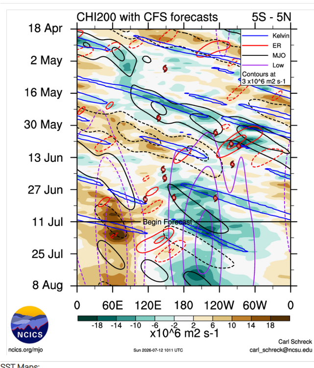
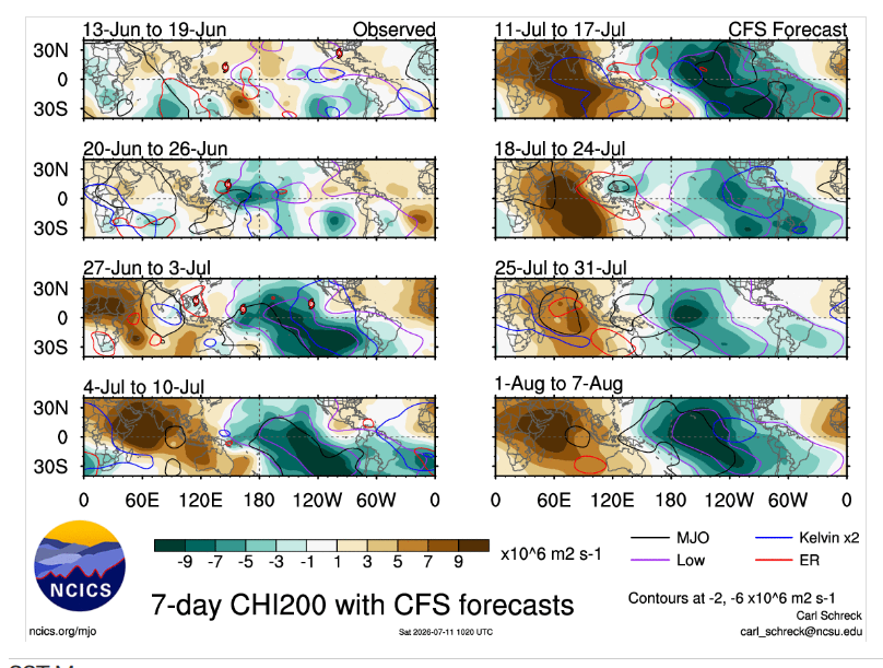
Its not like we seen last month,in the upcoming weeks into July the WWB is getting combatted with EWB.Even the EPS shows this to some extent.But this still could have destructive interference with the MJO signal with RW AND KW,regradless the chances of MJO moving out of the WP seems real to me,its not going to happen for awhile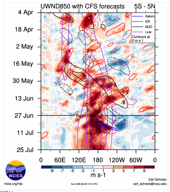
-
2026-2027 Super El Nino
jaxjagman replied to Stormchaserchuck1's topic in Weather Forecasting and Discussion
You for sure could be right.But it seems like the MJO is going to get destrucive interference from this Roosby Wave and this KW in the upcoming days epecially when the EWB ancounters into the 2nd week of huly seemingly,As this RW moves west it seems very possible the MJO signal will strengten just east of the IDL,this is why you see SOME RMMS killing the MJO signal,towards the COD from the WP,seems possible the MJO stays into the WP longer and possibly stronger -
2026-2027 Super El Nino
jaxjagman replied to Stormchaserchuck1's topic in Weather Forecasting and Discussion
The Rossby Wave is going kick off a strong Phoon easpcially if the Euro were to be right on the 0Z run today in the upcoming days,that would potentially be catastrophic if it were to take that route for Southern Japan as it heads into the Sea of Japan,tho this far out we dont know what troughs will even steer it -
Models have been shitty,the MCS is going into the OV riding the boundary which looks to stationary,surprised they kept the 5% last update
-
New Years eve was a historic ice storm in West and Cen Tn,but that was a nuetral ENSO i believe ,also75-76 was basically NINA as well,just saying
-
...Mid-South/Tennessee/southern Kentucky to North Carolina... Multiple MCVs, including across far south-central Missouri and southeast Kansas at midday, will influence the region as they progress east-southward generally toward Kentucky and Tennessee. Related flow enhancement is evident in regional WSR-88d VWP data, and particularly in the 12z Lamont, OK observed sounding (40+ kt 4-9km AGL). See Mesoscale Discussion 1346 for additional short-term details. These MCVs will influence and semi-focus thunderstorm development within a moist and increasingly unstable boundary layer from the southeast Missouri/northeast Arkansas border vicinity into Kentucky and Tennessee. This includes the possibility of some supercells and well-organized clusters in the presence of 35-40 kt effective shear. Pockets of wind damage will be the most common risk, but some tornado potential will exist as well. Additional severe storms capable of wind damage are also expected farther eastward into the Carolinas this afternoon through around mid-evening.
-
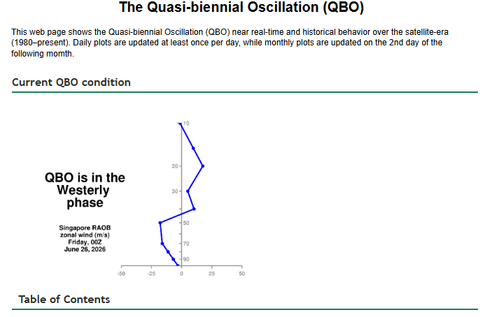
We are already in a WQBO,it should strnhgten into fall,winter We dont do horrible in winter with the combo.ENSO.Wet summer dry aatumn and wet winter,of course you should be comcerned with ice
-
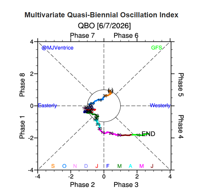
I'll side with you right now Carver But i'm not exactly sure what analog you would even start with ATM. in the strong Ninos in 91-92 and 97-98 winter both had a EQBO Now the strong NINO of 2015-16 had a WQBO but the QBO flaked out into winter,not sure thats a worthy analog year or could we see a repeat,dunno.Here is a paer by Kang,WooSoo and Chun on this https://agupubs.onlinelibrary.wiley.com/doi/full/10.1029/2022GL100101
-
Dont even look severe hardly Wed,go figure with the models in the mid range..lol
-
2026-2027 Super El Nino
jaxjagman replied to Stormchaserchuck1's topic in Weather Forecasting and Discussion
+PDO can happen even in a NINA,but more likely in a NINO,maybe more study to what actually starts a period?Dacula has the Index of the PDO going back into the last century https://www.daculaweather.com/4_pdo_index.php -
Maybe South east TN can get some storms later,cold front is still well out west but the Lapse rates and low level shear showing isnt that great later on,but there is convection that has recently popped up alomg the TN/MS line,guess we will see later.Wed looks to better as Jeff mentioned above,but even that the GFS fluctuates each run seemingly
-
2026-2027 Super El Nino
jaxjagman replied to Stormchaserchuck1's topic in Weather Forecasting and Discussion
Im kinda skeptic you see any big change in the SST'S in the east.Seems like we are fixing to see a WWB getting combatted with possibly a strong EWB,which is why you see the RMMS showing a decent signal into the WP when we get into July and beyond,other than that maybe a ERW off the Peruvian coast which could possibly warm 3 up,should not be much going on well into July -
Short range models whiiffed,better convection was seemingly in SW Tn,but nothing really severe
-
Maybe someone will get a good snow strorm this winter,other than that its more than likely going to be AN,we seem to be already headed towards WQBO the next few weeks,more than likely a brick PV probably this winter
-
2026-2027 Super El Nino
jaxjagman replied to Stormchaserchuck1's topic in Weather Forecasting and Discussion
-
2026-2027 Super El Nino
jaxjagman replied to Stormchaserchuck1's topic in Weather Forecasting and Discussion
Has there ever been a ENSO maybe comparable to this on other than maybe 2009?Even this WWB upcoming is seemingly going to combatted more or less with a EWB


