-
Posts
9,079 -
Joined
-
Last visited
Content Type
Profiles
Blogs
Forums
American Weather
Media Demo
Store
Gallery
Everything posted by jaxjagman
-
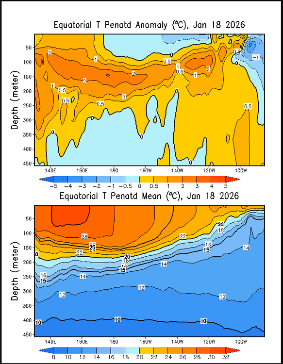
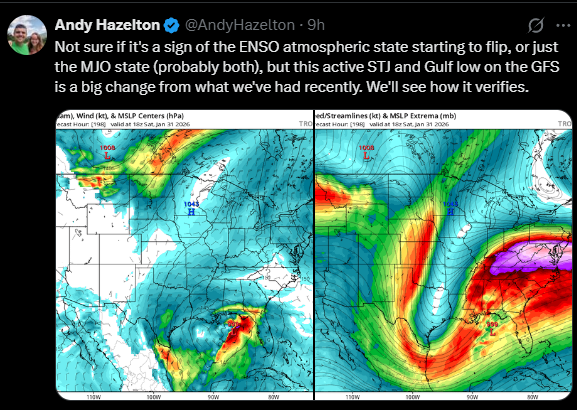
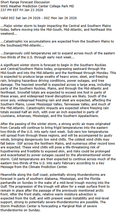
I agree with what Andy says,this isnt NINA like with this storm.The most Catastrophic ice storms was in a NINO back into the 1950's and 90's in mid and west Tn That cold pool in the east should possibly get over taken and making the ENSO into a more Modoki but weak ENSO into spring.In typical sorta speaking this should be a early season severe season.least to my thinking
-
-
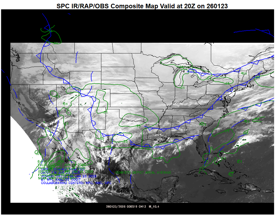
Seriously? Its public info https://www.spc.noaa.gov/exper/compmap/
-
Son went to fill his car up after i told him,he said 7-11 and Krogers had no gas..lol
-
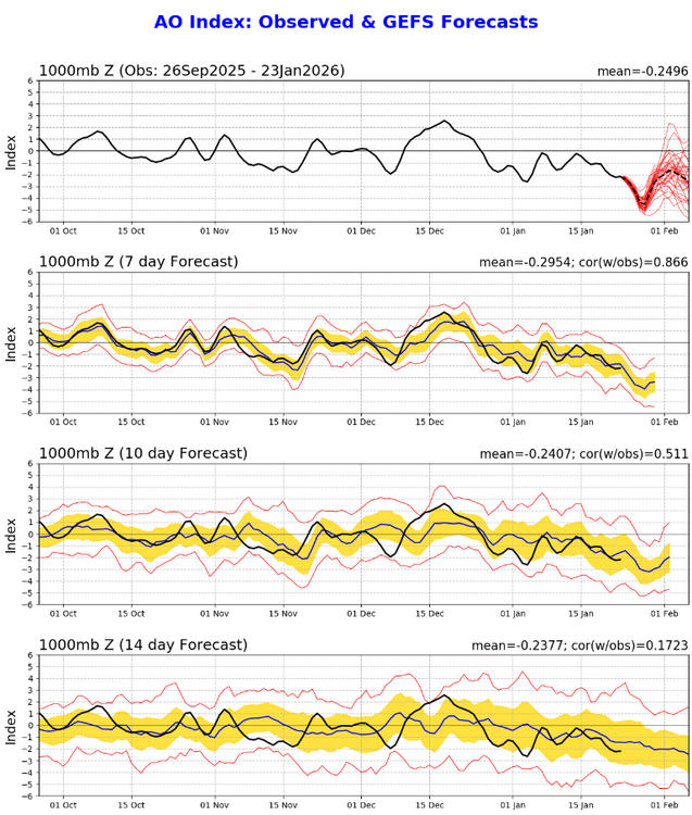
+VE PNA and AO dropping almost 4 sigma BN,will it get cold?...LOL.What you'd really like to see is a more +ve NAO,this would shift the trough axis further west it would seem anyways
-
I posted day 2 just because Day2 seems more important sorta speaking
-
Day 3 Convective Outlook NWS Storm Prediction Center Norman OK 0230 AM CST Fri Jan 23 2026 Valid 251200Z - 261200Z ...THERE IS A MARGINAL RISK OF SEVERE THUNDERSTORMS OVER PORTIONS OF THE CENTRAL AND EASTERN GULF COAST... ...SUMMARY... Isolated strong to severe storms are possible over portions of the central and eastern Gulf Coast Sunday. ...Synopsis... Intensifying mid-level troughing over the central US will continue to amplify as it moves eastward Sunday. Strong cyclonic flow aloft will overspread portions of the southern US as a second embedded perturbation skirts the central and eastern Gulf Coast before being consolidated into the broader upper trough. Ascent from this shortwave will allow a weak surface low to develop and shift east/northeastward over the Tennessee Valley before moving offshore of the Carolina coast early Monday. Attendant to the low, a strong arctic cold front will sweep eastward across the southern CONUS. Modified Gulf moisture will be in place, supporting weak instability and some potential for strong to severe storms. ...Gulf Coast... As the surface low moves onshore and deepens ahead of the advancing shortwave early Sunday, inland moisture advection (60s F surface dewpoints) is expected to increase over southeastern LA into southern MS/AL and the western FL Panhandle in the wake of a surface warm front lifting northward. Ongoing elevated convection near the advancing cold front will likely encounter a warming/moistening boundary layer sufficient for some intensification through the day across south-central AL into the FL panhandle and southwestern GA. Increasing southwesterly flow aloft (EBWD of 50-60 kt) will be favorable for some storm organization amidst weak buoyancy (MLCAPE ~ 500 J/kg). A broken band of storms along the cold front may pose a risk for isolated damaging gusts and brief tornado where the boundary layer can destabilize sufficiently inland south of the prominent cold air intrusion/damming and ongoing winter weather. The cold front will then continue offshore overnight with the severe risk diminishing as a much colder air mass envelops the eastern CONUS.
-
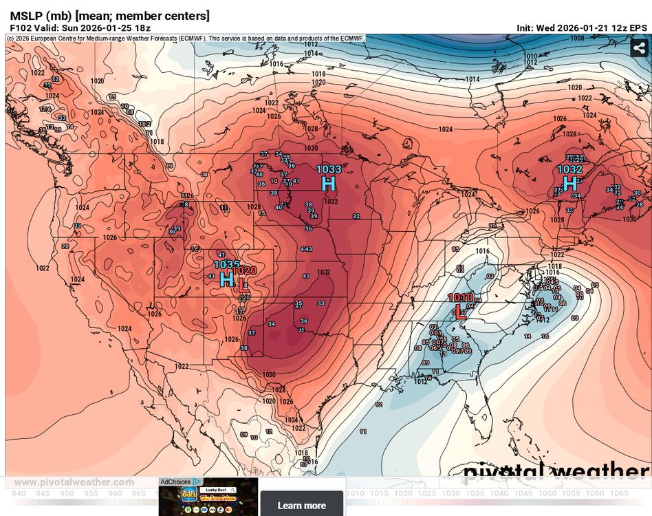
This could actually be what the GFS is showing.Where it stalls or slowly moves Sun the LP down into Cen Al,with convection down south of it,plus convection could even pull the LP further South than what the models are showing,but probably one of the reasons why you see the Euro showing this LLJ 60-70KTS along the TN/AL border and the GFS doesnt ,not saying this is a big game changer.Its a different set up,if the LP was towards the GOM,it would be robbing the moisture flux
-
Day 2 Convective Outlook NWS Storm Prediction Center Norman OK 1059 AM CST Fri Jan 23 2026 Valid 241200Z - 251200Z ...NO SEVERE THUNDERSTORM AREAS FORECAST... ...SUMMARY... The risk for severe thunderstorms appears negligible across the U.S. Saturday through Saturday night. ...Discussion... Downstream of amplified split flow across the Pacific into western North America, it still appears that several short wave troughs will gradually consolidate into larger-scale mid-level troughing across the Rockies and Great Plains into Mississippi Valley through this period. This is likely to include at least a couple of merging perturbations of Canadian Arctic origin digging across the international border through the northern U.S. Rockies and Great Plains, and another emerging from the northern mid-latitude Pacific before digging inland across the Pacific Northwest coast through the southern Great Basin. Yet another impulse, emerging from the southern mid-latitude eastern Pacific, and currently in the form of a mid-level low as it digs toward Baja, is forecast to undergo considerable deformation while being forced eastward, then northeastward, across the northern Mexican Plateau into the southern Great Plains by late Saturday night. This is being preceded by the southeastward development of an expansive cold surface ridge across much of the nation to the east of the Rockies, as far south as the Gulf coast vicinity. While highest surface pressures centered across the Upper Midwest, Ohio Valley and Great Lakes at the outset of the period are forecast to continue to fall while shifting northeastward, it appears that the residual Arctic air mass will impede significant inland surface cyclogenesis. Models do still indicate modest deepening of surface troughing in one corridor across the lower Mississippi Valley toward the lower Ohio Valley (as well as in another near/offshore of the Carolina coast) by late Saturday through Saturday night. Elevated moisture return above the cold air to the north and northwest of this feature appears likely to be accompanied by weak destabilization. However, appreciable boundary-layer destabilization along the surface trough axis, inland across southeastern Louisiana through southeastern/east central Mississippi and adjacent western Alabama by 12Z Sunday, appears unlikely. This is expected to minimize the risk for severe weather. ...Southern Great Plains/Lower Mississippi Valley... Convection allowing output and other guidance suggest that the most substantive potential for thunderstorm development will largely focus just to the cool side of the surface frontal zone, near/inland of mid/upper Texas Gulf coastal areas through Louisiana and central/southwestern Mississippi Saturday through Saturday night.. Layers of developing weak conditional and convective instability further aloft, and to the west through north, might become supportive of convective development capable of producing lightning, anywhere from the Texas South Plains and Big Country into the Mid South. The extent of this potential remains a bit unclear due to spread evident in the model output. However, further adjustments to the 10 percent thunder line may be needed in subsequent outlooks for this period. ..Kerr.. 01/23/2026
-
OBS right now,CF moving through Tn
-
That was a good run all things considering
-
One thing could happen if you get the low where the NAM is this will try Damn,look how fast that is also..lol
-
Was about to say
-
You;d rather see it speed up tho not slow down,this is gonna be a brutal run
-
Looks to be the WSW is for the southern parts
-
URGENT - WINTER WEATHER MESSAGE National Weather Service Nashville TN 1136 AM CST Thu Jan 22 2026 TNZ005>011-023>034-057-059>066-075-077>080-095-230900- /O.UPG.KOHX.WS.A.0001.260124T0000Z-260126T0000Z/ /O.NEW.KOHX.WS.W.0001.260124T0600Z-260126T0000Z/ Stewart-Montgomery-Robertson-Sumner-Macon-Clay-Pickett-Houston- Humphreys-Dickson-Cheatham-Davidson-Wilson-Trousdale-Smith- Jackson-Putnam-Overton-Fentress-Hickman-Williamson-Maury-Marshall- Rutherford-Cannon-De Kalb-White-Cumberland-Bedford-Coffee-Warren- Grundy-Van Buren-Giles- Including the cities of Nashville, Gordonsville, Livingston, New Johnsonville, Dickson, Mount Juliet, Jamestown, Spencer, Franklin, Gallatin, Byrdstown, Hendersonville, South Carthage, Allardt, Sparta, Murfreesboro, Pulaski, Erin, Brentwood, La Vergne, Gainesboro, Altamont, Smithville, Tennessee Ridge, McEwen, Smyrna, Coalmont, Kingston Springs, Shelbyville, Lafayette, Celina, Columbia, Ashland City, Manchester, Waverly, Dover, Clarksville, Carthage, Woodbury, Springfield, Crossville, Lewisburg, Lebanon, Tullahoma, McMinnville, Goodlettsville, Cookeville, Hartsville, and Centerville 1136 AM CST Thu Jan 22 2026 ...WINTER STORM WARNING IN EFFECT FROM MIDNIGHT FRIDAY NIGHT TO 6 PM CST SUNDAY... * WHAT...Heavy mixed precipitation expected. Total snow and sleet accumulations between 2 and 8 inches and ice accumulations up to one quarter inch.
-
Jeremy DeHart @JeremyDeHartWX Would anticipate that Thursday night's 00Z runs will be important with missions planned tomorrow for both the Baja low and the thermo profiles in the Gulf
-
https://x.com/JeremyDeHartWX
-
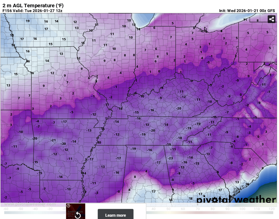
We got cold like that in 1985,today On January 21, 1985...Temperature at Nashville drops to -17, setting an all-time record low. Other record lows include Allardt (-27), Carthage (-17), Celina (-20), Centerville (-26), Columbia (-20), Cookeville (-22), Crossville (-21), Crossville (Experiment Station) (-25), Dickson (-23), Franklin (-21), Lebanon (3 W) (-20), Lewisburg (-20), Livingston (-25), Monteagle (-20), Mount Pleasant (-17), Neapolis (-23), Shelbyville (-20), Smithville (-24), and Woodbury (-28).
-
Left clickOHX doesnt look as cold,but its 10-15:1 ratios by what they say




.thumb.png.35662d8924d2523ecdf910c31e94b0f8.png)

