-
Posts
9,079 -
Joined
-
Last visited
Content Type
Profiles
Blogs
Forums
American Weather
Media Demo
Store
Gallery
Everything posted by jaxjagman
-
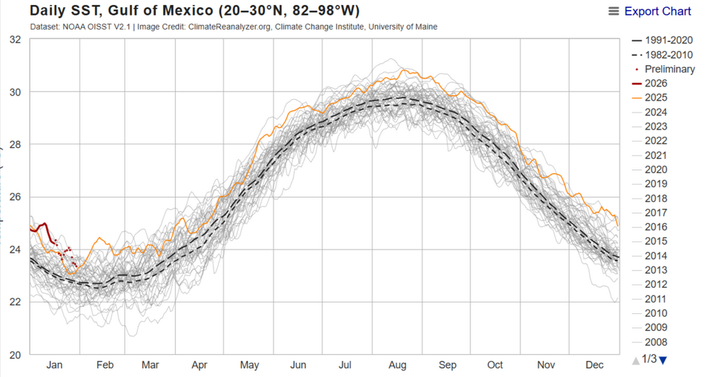
Just look at the red line,the GOM has been one of the warmest since the 1980's
-
Dont agree with this.This is more or less some hybrid weather pattern this winter,plus while it can happen the atmospheric river into the west is more Nino than NINA,you cant possibly say the west has been dry this winter,California is over 300% in some parts of abnormal QPFS
-
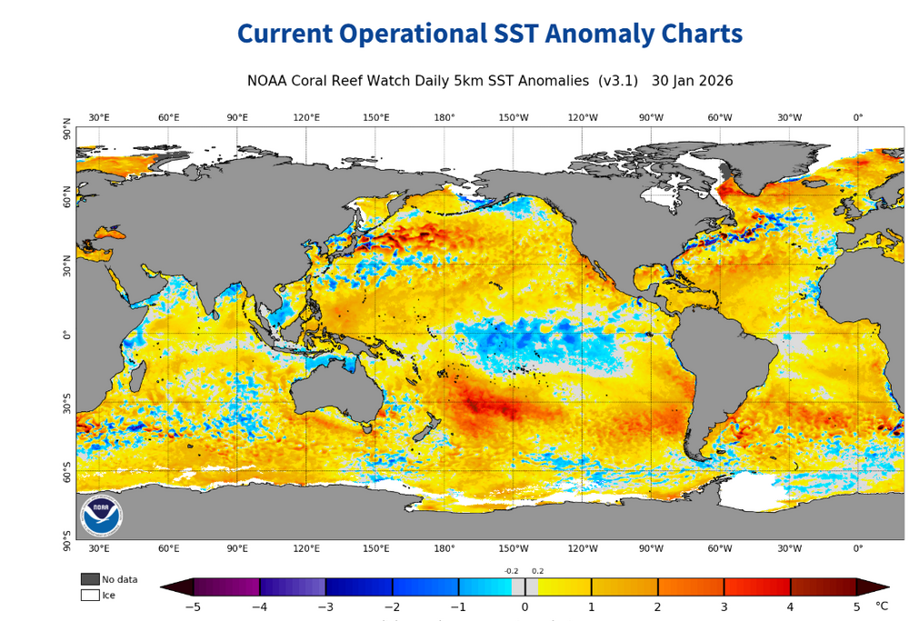
SSTS in the modern day era since summer has been well AN since summer,still be interesting to see what happens in the upcoming days
-
-
-
-
-
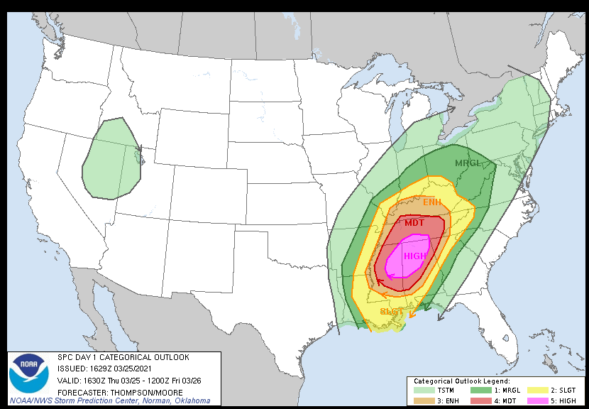
Yeah but there top analog was1-25-2021 today,this was the Fultondale.Al EF3,this makes no sense to me
-
https://www.cbc.ca/news/canada/windsor/lake-erie-january-more-ice-23-years-9.7067884
-
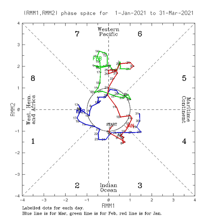
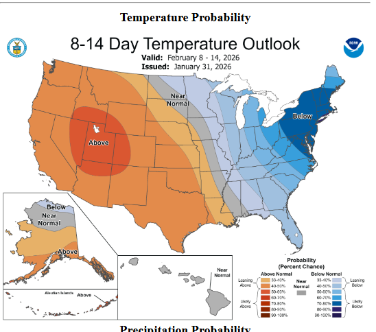
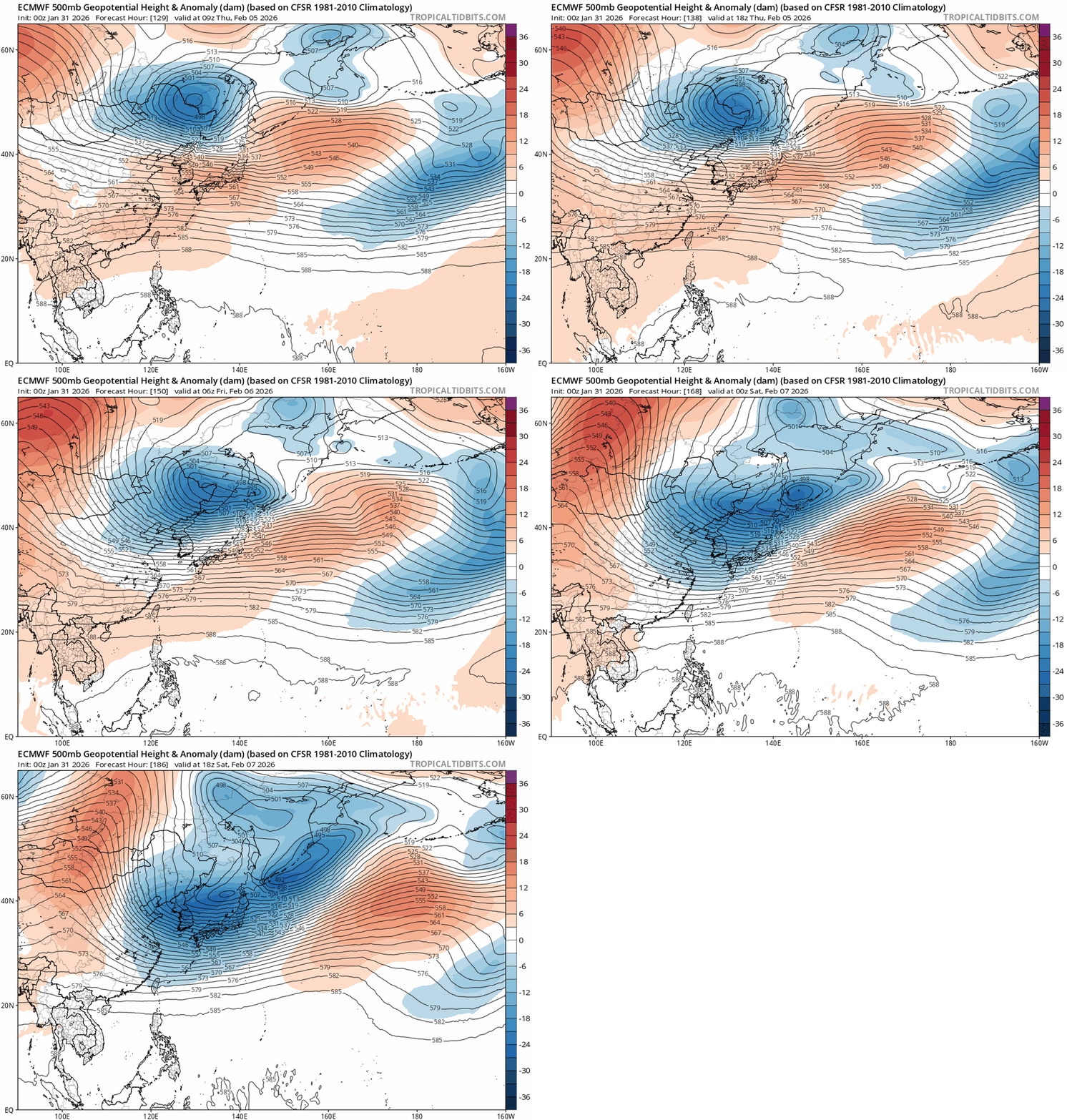
Gonna be a Valentines Sweetheart for someone and the Kiss of Death for someone.Hard to figure this one out but its still a couple weeks out.GEFS shows the NAO/PNA possibly crapping out FOR US,but we are talking two weeks away/JMA has the MJO moving through P1-2,thats typically a cold look in J/F/M
-
I'm ready for severe now https://www.spc.noaa.gov/climo/dataviewer/?hzrd=tor§=conus&intv=day&pd=&thrs=0
-

Jan 30th-February 1st 2026 Arctic Blast/ULL Snow OBS Thread.
jaxjagman replied to John1122's topic in Tennessee Valley
Light snow shower,it wont last much longer it seems ATM -
Good luck to ya'll in the East.
- 782 replies
-
- 9
-

-

-
- extreme cold
- snow
-
(and 1 more)
Tagged with:
-
We got all our stuff back yesterday afternoon,then last night the internet crashed about 830,was back on this morning. Charged our phones in the car,using the phone at all was a pain in the ass,most of the time it was one bar if you got lucky with no wi-fi. Our area looks like a tornado hit with no house damage unless you had a tree fall on it
-
We lost power for a bit,Wi-Fi is down with Comcast’s no tv getting on the the net is sketchy
- 618 replies
-
- observations
- obs thread
-
(and 1 more)
Tagged with:
-
Back to ZR again,CF passed through Mid Tn back down to 31 now
- 618 replies
-
- 4
-

-
- observations
- obs thread
-
(and 1 more)
Tagged with:
-
esoscale Discussion 0049 NWS Storm Prediction Center Norman OK 0746 PM CST Sat Jan 24 2026 Areas affected...Northern Louisiana into eastern Arkansas...northwest Mississippi...and far western Tennessee Concerning...Winter mixed precipitation Valid 250146Z - 250645Z SUMMARY...Another round of freezing rain and sleet is expected to spread out of northern Louisiana into eastern Arkansas and northwest Mississippi. Freezing rain rates upwards of 0.05 inch/hour appear likely for some locations. DISCUSSION...Recent radar mosaics show a developing plume of precipitation across central to northern LA - likely associated with strengthening warm advection between 925-850 mb. Over the next several hours, an uptick in low-level winds should promote further augmentation of isentropic and frontogenetical ascent across the lower MS River Valley. Regional 00z RAOBs from SHV and LZK sampled a stout (4-12 C) warm layer between 850-700 mb that will melt hydrometeors as precipitation spreads north/northeast. Sub-freezing surface temperatures will promote some degree of re-freezing near the surface, though locations with temperatures at or near/below 15 F will likely be sufficiently cold (and have a sufficiently deep sub-freezing layer) to promote sleet as the predominant precipitation type. Warmer locations will likely observe freezing rain (with freezing rain rates up to 0.05 inch/hour) with periods of sleet possible. Based on latest surface observations, freezing rain appears most probable across southeast AR into northwest MS with sleet more likely for locations further north into east-central AR and far western TN.
- 618 replies
-
- 1
-

-
- observations
- obs thread
-
(and 1 more)
Tagged with:
-
Yeah if we had a faster solution and kept that ULL to the NE you wouldn't be seeing this stout inverted trough with a CAD
- 618 replies
-
- 1
-

-
- observations
- obs thread
-
(and 1 more)
Tagged with:
-
Yeah,several days ago the models showed this winding down about now,not get going,.The slower solution allowed the LP to cut up because we lost the ULL to the NE and allowed HP to build in the east
- 618 replies
-
- 1
-

-
- observations
- obs thread
-
(and 1 more)
Tagged with:
-
Still 20 here,mesoscale shows that changing over to IP around 3CST,then Rap and HRRR shows ZR around midnight
- 618 replies
-
- observations
- obs thread
-
(and 1 more)
Tagged with:
-
Mesoscale Discussion 0045 NWS Storm Prediction Center Norman OK 1217 PM CST Sat Jan 24 2026 Areas affected...northern MS to the southern Appalachians Concerning...Freezing rain Valid 241817Z - 242345Z SUMMARY...Freezing rain mixed with sleet is expected to expand across parts of the Tennessee Valley to the southern Appalachians through late afternoon. The most likely corridor for appreciable accretion appears centered on north-central Mississippi, northwest Alabama, and southeast Tennessee. DISCUSSION...A broad swath of mixed winter precip is ongoing from KY/TN southwest to LA. The initial leading activity has largely remained as sleet and snow, with greater liquid-equivalent rates in sleet, freezing rain, and rain over LA. This latter plume is expected to be the most prolific for freezing rain rates as it shifts northeast through late afternoon. Liquid-equivalent rates of .05 to .25 in/hr should remain common. Despite ample low-level isentropic ascent, guidance is quite insistent on expanding the above-freezing warm nose north-northeast across northern MS to eastern TN through 00Z. A 15Z UL-Monroe sounding sampled around 12C at 900 mb, indicative of a classic freezing rain/mixed sleet profile. The overall setup suggests that these should become the primary PTYPEs across central/northern MS through northwest AL to southeast TN. ..Grams.. 01/24/2026
- 618 replies
-
- 2
-

-

-
- observations
- obs thread
-
(and 1 more)
Tagged with:
-
Mesoscale Discussion 0043 NWS Storm Prediction Center Norman OK 0853 AM CST Sat Jan 24 2026 Areas affected...northeast TX...southern AR...northern LA...western MS Concerning...Winter mixed precipitation Valid 241453Z - 242000Z SUMMARY...Moderate to heavy freezing rain and sleet are expected to persist across the Ark-La-Tex to Ark-La-Miss regions into early afternoon. Liquid-equivalent precipitation rates of a tenth to quarter-inch per hour should be common, locally up to a half-inch per hour. DISCUSSION...A swath of moderate to heavy mixed precipitation is ongoing across east TX and the Ark-La-Tex. Surface observations confirm hourly precipitation rates of .10-.25 in/hr are common, up to around .50 in/hr. 12Z guidance is rather consistent in indicating this swath of precip persisting through at least early afternoon, gradually shifting east-northeast amid rather pronounced low-level warm theta-e advection. A classic freezing rain to sleet sounding was sampled at 12Z in SHV. This type of thermodynamic profile should continue to steadily push southward in northern LA. Farther east, the surface freezing line should only drift to nearly stall across western MS into the early afternoon. ..Grams.. 01/24/2026
- 618 replies
-
- 1
-

-
- observations
- obs thread
-
(and 1 more)
Tagged with:
-
Dry air,its gonna take a bit,we went through it this more now we have SN
- 618 replies
-
- 3
-

-
- observations
- obs thread
-
(and 1 more)
Tagged with:


.thumb.png.19662c079c463c3bf5b984cf77310729.png)
