jaxjagman
-
Posts
9,156 -
Joined
-
Last visited
Content Type
Profiles
Blogs
Forums
American Weather
Media Demo
Store
Gallery
Everything posted by jaxjagman
-
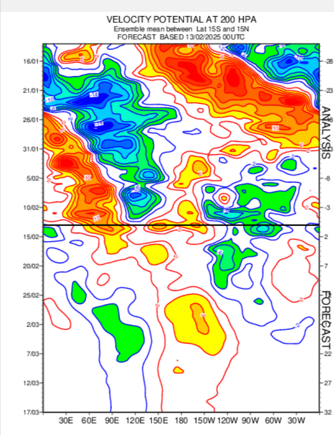
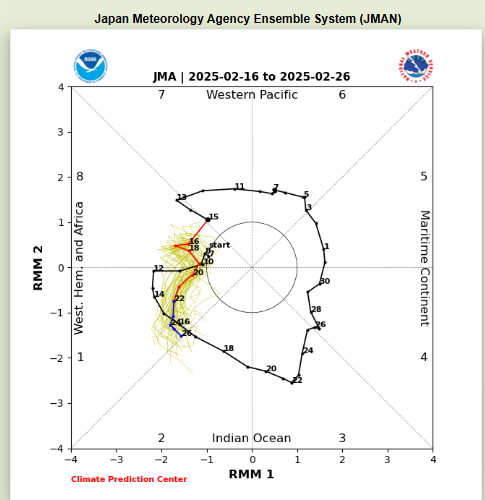
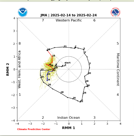
Rossby Wave is fixing to cause chaos with the RMMS signal the next few days.
-
I was thinking the same but more north of 1-40,theyve had quite a winter from snow,flooding and severe
-
https://www.weather.gov/media/meg/WinterStormCriteriaMEG.pdf they must be pretty damn confident..lol
-
WSW in general go out 12-36 hours this is like 72 hrs..lol
-
Actually strange they'd do this so early,its not the criteria of WSW
-
But basically every long range model is showing severe so we will see
-
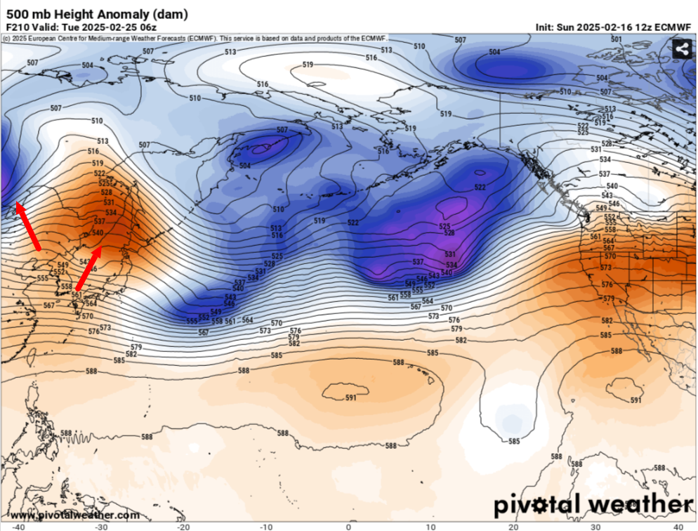
Think the next chance of severe should come right after Met spring starts.Euro shows a ridge building on top of Japan which should be a ridge in the NE and heights falling from a trough into Mongolia which should/could be a -PNA

-
Euro is back to record breaking temps early Friday morn
-
-
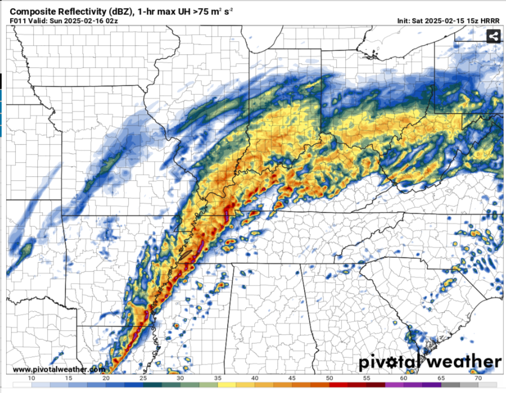
When i went to bed there was a few tor warned cells in MS and up up torwards the AL/TN line,i couldnt hang no more i was tired.But for us it pretty much behaved
-
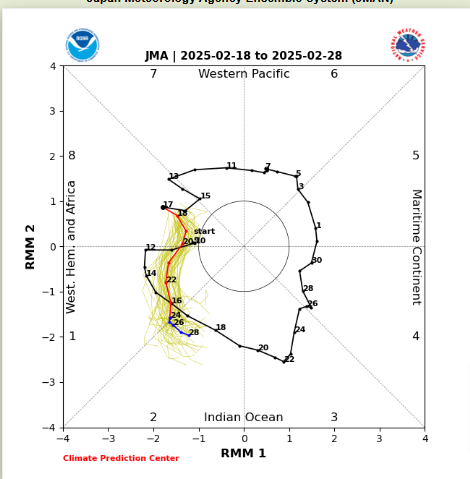
Lots of waves going on,in which seemingly is destroying the MJO signal.I'd probably run with the JMA right now because it seems to be the most tightly clustered
-
LONG TERM... (Monday Night through next Sunday) Issued at 111 AM CST Sun Feb 16 2025 For the long term, we shift our focus to the next system that will likely bring some accumulating snowfall to middle TN Wednesday. The current NBM probabilities of at least 2 inches or more of snow is 40% south of I-40, and between 60-80% north of I-40. The probability of 4 inches or more is 50-70% north of I-40. Sampling a few model soundings from both the NAM and the GFS, temperature profiles are well below freezing with ample moisture in the dendritic growth zone, so as of now, this looks to be an all snow event. As the trough exits off to the east Thursday, bitterly cold temperatures will settle in at the surface as high pressure builds in from the midwest. We will remain dry through the remainder of the forecast period, but again, it will be cold. Current high temperature forecast has the majority of middle TN aside from the far southern counties below freezing for 48+ hours for Wednesday-Thursday. Some slight warming will occur Saturday and Sunday as upper level ridging builds over the Ohio River Valley with temperatures getting back into the 40s.
-
Vortex,you guys have a tornado?
-
While the line of storms in passing through East Tn models show it's snowing into NW Tn
-
Could be some storms ahead of that line Could be some discrete cells ahead of that line into the early evening

-
Each run now seems to be creeping up to the typical 1-40 battle zone,next few model runs it wouldnt surprise me if its all rain and not snow here
-
Sure the Euro is record breaking temps for the day here,last time it got that cold here was Feb 5,1996
-
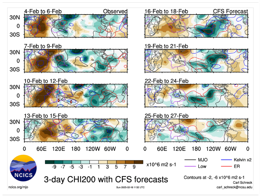
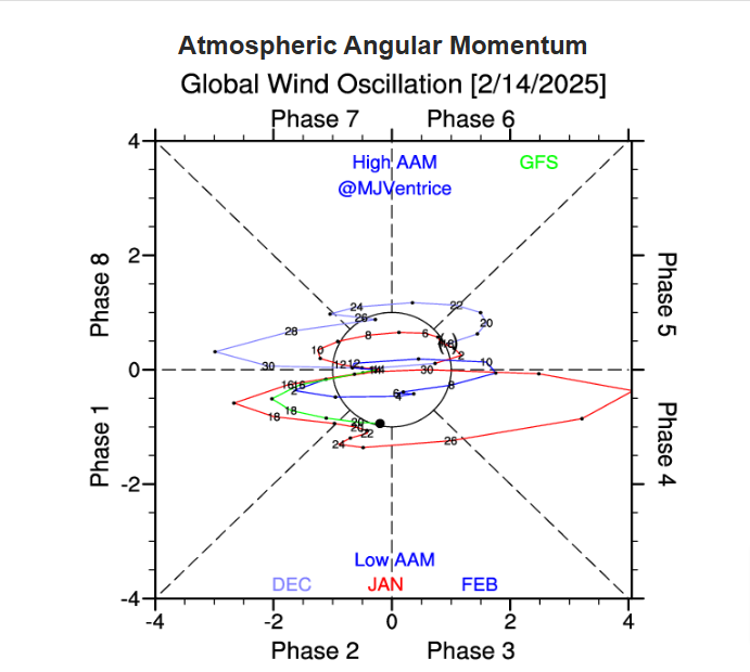
JMO and could be wrong.but the MJO and the Euro the signal is getting disorted by a KW into NH,the CFS as of late is showing this along with the Euro and even the JMA shows this,the MJO is moving fast and should be into the IO as we get into Met spring,the map i showed up above even the AAM which was doing its cycles it flips once again the next couple days,it did the same around the 15th of Jan,it showed you a pattern change upcoming


-
Excessive Rainfall Discussion NWS Weather Prediction Center College Park MD 225 PM EST Fri Feb 14 2025 Day 2 Valid 12Z Sat Feb 15 2025 - 12Z Sun Feb 16 2025 ...THERE IS A HIGH RISK OF EXCESSIVE RAINFALL OVER PORTIONS OF THE TENNESSEE AND OHIO VALLEYS... ...Ohio and Tennessee Valleys... Confidence in a very impactful, life-threatening and significant heavy rainfall and flash flood event remains high beginning late tonight through Saturday night across portions of the Ohio and Tennessee Valleys. While there is some subtle variability in the placement of the heaviest QPF (northwest to southeast), some clustering of the guidance happened this cycle for a swath of 3-6" from western TN through central Kentucky with a signal for isolated amounts up to 8". The environment will be quite unusual for mid-February. The combination of MUCAPE of 500-1000 j/kg and PWATs reaching around 1.5 inches has only rarely been observed in KY/TN at this time of year, and would be supportive of 1-2 inch per hour rain rates in the most organized and intense convection. A powerful southwesterly LLJ over 60 knots, oriented at an acute angle to the developing warm front, will favor backbuilding into the region of stronger instability. And the overall mean flow should favor some periods of training convective clusters or bands near the warm front and surface low track. All of these ingredients are fairly classic for impactful flash flooding cases, and significant impacts are anticipated in this one as well. Given all of this, a High Risk was introduced for portions of NW TN through central KY, where life-threatening and significant flooding is anticipated. Elsewhere, not many changes were made to the Moderate/Slight Risk areas, with some pulling back out of eastern KY and the central Appalachians where the trends for less QPF continues somewhat. However, don't want to downplay that area given its sensitivity and antecedent conditions as well.
-
Pretty impressive,especially if the models are wrong as much more convection being shown,could be brutal as much rain theyve gotten recently
-
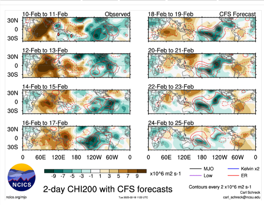
Still think the MJO is having constructive interference.This whole pattern is quite like what we seen in Mid Jan.I still think shortly after Met spring starts it should get quite active once again,but we should see several days of BN temps upcoming

-
Day 2 Convective Outlook NWS Storm Prediction Center Norman OK 1120 AM CST Fri Feb 14 2025 Valid 151200Z - 161200Z ...THERE IS AN ENHANCED RISK OF SEVERE THUNDERSTORMS ACROSS NORTHERN LOUISIANA...SOUTHEAST ARKANSAS...MUCH OF MISSISSIPPI...FAR SOUTHWEST TENNESSEE...AND WEST-CENTRAL ALABAMA.... ...SUMMARY... Severe weather is expected from East Texas into much of the Southeast and parts of the Mid-South on Saturday. Scattered to numerous damaging wind gusts and a few tornadoes are the primary threats. Storms are expected from late afternoon through the overnight hours. ...Synopsis... A mid-level trough will traverse from the Southwest Saturday morning to the Mid-Mississippi Valley by 12Z Sunday. As this trough becomes negatively tilted after 00Z, the surface low will rapidly deepen by 10+ mb as it moves from central Arkansas to northeast Ohio. A cold front will extend southwest from this surface low and sharpen through the evening before advancing east during the late evening and into the overnight hours. ...Mid-South and Southeast... An expansive region of strengthening low-level flow will advance a broad warm sector northward across the Gulf Coast states Saturday morning. North of this warm front within a 50 knot low-level jet, elevated thunderstorms are expected. Weak instability and shear should result in mostly sub-severe storms, but isolated large hail may be possible. Expect persistent thunderstorm activity along the diffuse cold front from far East Texas to the Mid-Mississippi Valley through the morning to early afternoon with mostly sub-severe storms. However, richer theta-e will interact with the frontal zone by mid-to-late afternoon which should result in deeper, more robust updrafts. In addition, stronger mid-level flow will start to overspread the warm sector, promoting stronger deep-layer shear. Supercells are anticipated from southeast Arkansas to southwest Tennessee by this time with a threat for all severe weather hazards including the potential for a few strong (EF2+) tornadoes. However, this window of more discrete storm mode will likely be fairly limited as the cold front starts to surge east around 00Z and a squall line develops. The environment ahead of this squall line will remain favorable for severe wind gusts and QLCS tornadoes through the evening. Eventually this squall line will encounter weaker instability across central/eastern Tennessee and Alabama and the severe weather threat will likely start to wane. One exception may be across far southeast Mississippi, southern Alabama, and into the Florida Panhandle. After 06Z, some influence of the approaching mid-level vorticity maximum could result in more robust convection across this region where greater instability will remain. The low-level jet is also forecast to strengthen across the region during this timeframe with STP values peaking perhaps around 2 to 3. 12Z CAM guidance suggests the potential for some pre-frontal development late in the period, but they are not overly strong at this time. If more robust pre-frontal storms become likely, in addition to the QLCS threat associated with the squall line, greater tornado probabilities could be needed across this area. ..Bentley.. 02/14/2025
-
Pattern is similar to our cold spell back into Jan,wont be as cold but still BN.Think the MJO is still progressing and the signal by most models want to mute it back or close into the COD,think the reason is a KW in the NH/Africa,as we get closer to then end of wk3.When we got cold into Jan the SOI was around -20+ and the AAM albeit was into the COD it was still +ve,the AAM IMHO showed the flip to a crappie upcoming pattern around the 14th of Jan. 14 Feb 2025 1011.54 1009.30 -12.01 13.41 9.01 13 Feb 2025 1012.66 1009.05 -5.43 13.68 9.22 12 Feb 2025 1013.17 1008.40 0.14 13.25 9.32 11 Feb 2025 1012.74 1006.95 5.04 12.61 9.45 10 Feb 2025 1012.30 1004.05 16.86 11.75 9.56 9 Feb 2025 1012.49 1001.90 28.10 10.48 9.53 8 Feb 2025 1011.98 1001.55 27.33 9.08 9.27 7 Feb 2025 1013.14 1001.60 32.66 8.01 9.02 6 Feb 2025 1012.63 1001.30 31.65 6.80 8.63 5 Feb 2025 1011.64 1001.80 24.50 5.85 8.12 4 Feb 2025 1011.76 1003.20 18.35 5.21 7.72
-
I think for the most part we have a silent agreement with winter months.It's mainly winter talk and not severe,alot of people would rather see snow than severe other than it night be a severe pattern we use the severe threats in the severe thread all year.You can post there and ask questions or add on if you like.
-
Day 4-8 Convective Outlook NWS Storm Prediction Center Norman OK 0359 AM CST Wed Feb 12 2025 Valid 151200Z - 201200Z ...DISCUSSION... ...Day 4/Saturday... Model guidance continues to forecast a strong upper-level trough moving through the southern Plains and into the Southeast. Some modest slowing of the trough has been noted, however. The trough will promote the deepening of the surface low in the ArkLaTex vicinity during the afternoon with further deepening expected into the evening as it generally progresses north-northeastward within the Mid-South/Ohio Valley. Moisture return will have begun Friday evening and will continue Saturday. Guidance shows a consistent signal for mid 60s F dewpoints extending into much of Louisiana/Mississippi, and Alabama. Upper 60s F dewpoints are possible closer to the Gulf Coast. Very strong wind fields are anticipated throughout the troposphere. Shear will be strong and, despite more modest mid-level lapse rates, buoyancy will be more than adequate for severe storms. The current expectation is for warm advection precipitation to be ongoing early in the period and for it not to make much, if any, southward progress until the late afternoon. A Pacific front in East Texas/Sabine Valley into the ArkLaTex may be the initial zone for stronger convective development. By the late afternoon onward, the cold front will begin to surge south and east. The low-level jet should remain strong into the afternoon and then increase to 50-70 kts during the evening. As the cold front surges, shear vectors will acquire a greater cross-boundary component. This strongly forced line will be capable of scattered to widespread damaging winds along with the threat for embedded circulations/QLCS tornadoes. One of the main questions that remain will be the degree of the tornado threat, which would increase with any discrete activity ahead of the cold front. Given the weak capping and strong forcing, pre-frontal discrete storms are plausible. The ECMWF shows some hint of this from central Louisiana into adjacent Mississippi. The eastern and northern extent of the greatest severe threat are also in question, but the intense low-level jet could produce severe-caliber gusts even with relatively shallow convection. The overall pattern, along with signals in both deterministic and ML guidance, suggest 30% severe probabilities are warranted for Saturday.