jaxjagman
-
Posts
9,156 -
Joined
-
Last visited
Content Type
Profiles
Blogs
Forums
American Weather
Media Demo
Store
Gallery
Everything posted by jaxjagman
-
 lol...if we miss out on snow from the mid of next week until Feb im going to severe,systems seem close to every 3-4 days
- 207 replies
-
- 4
-

-

-
- obs
- light snow
- (and 2 more)
-
Probably the next shift will,hard to believe they they wouldnt put out a WWA for the mountains
-
If the HRR is anywhere right there could we a weaker clipper riding the trough,least thats what im seeing,you can see this on its CAMS
- 207 replies
-
- 3
-
-
- obs
- light snow
- (and 2 more)
-
Maybe its about the same but you can still see when the LP gets into N/Carolina it is stronger Than the 12z was
- 207 replies
-
- 2
-
-

-
- obs
- light snow
- (and 2 more)
-
GFS has a stronger system with more wrap into East Tn this run
- 207 replies
-
- 2
-
-
- obs
- light snow
- (and 2 more)
-
Cumberland should be the jack pot as usual,if we get a dusing here i'd say it was a win
- 207 replies
-
- 3
-
-
-
-
- obs
- light snow
- (and 2 more)
-
That would be brutal in North Florida,maybe shades like the 2018 storm
- 207 replies
-
- 3
-
-
-
- obs
- light snow
- (and 2 more)
-
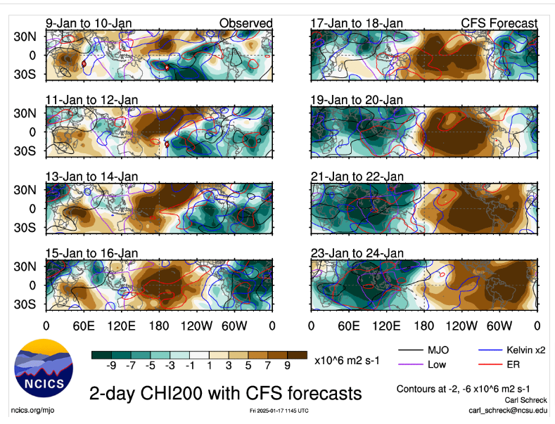
I think the MJO signal will get totally interfered with the next upcoming days and any model could be right TBH.IMHO like Carver said earlier the NAO will probably change the next several runs over and over, i still think temps could moderate some and towards the end of Jan it can get pretty cold again,depending on teleconnections
-
Starting a new severe thread since the last one was back into 2021,plus we want to keep severe out of winter threads unless we get a severe threat at any time. But this looks like a potential active season right now ATM.Right now the IO is fixing to come pretty active the next few days in which should/ could possibly strenghten LaNina upcoming the next weeks ahead as we head into March. So post your Forecast and OBS from now on here please
-
https://www.jacksonville.com/story/news/2023/12/20/snow-florida-record-snowfall-lowest-temperature-christmas-snowstorm-great-arctic-outbreak-record/71983060007/
-
Lots of moving parts leading up to the end of next week,throwing one piece off the others will follow
-
GFS is trying to put this year into the record books in Nashville
-
It took it long enough to make some noise potentially.Should take more hits with the MJO going into the IO,Maritime
-
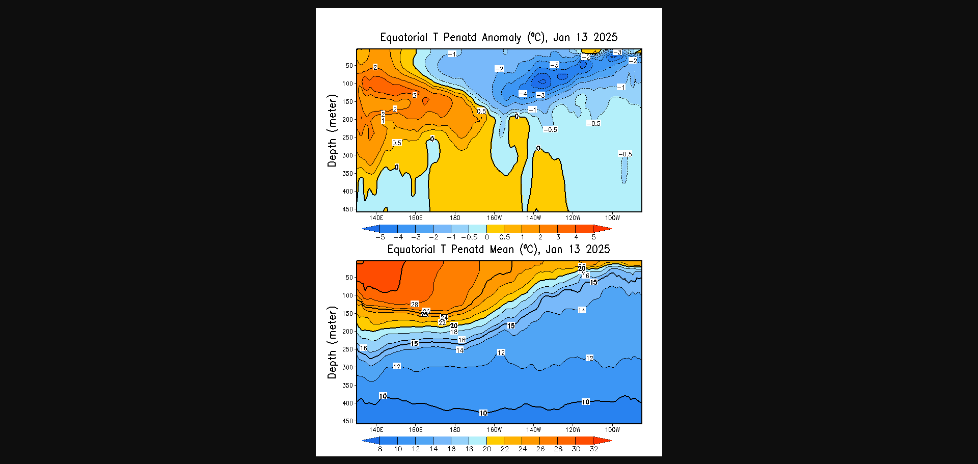
Its pretty wild how we continue to see these troughs in East Asia.At first i thought it was because the warm SST'S but then i remembered some of these SST'S this year are breaking records from last year,but we didnt see anything like this pattern last winter,possibly the ENSO,seems possible,we did have a strong NINO
-
Still think the JMA is right with the MJO,but i also think the Euro is also right ,just not as amped.If the CFS is anywhere right it does show a strong MJO into Africa and into the IO,but in a NINA base state the signal will get destructive interefrnce into the IO from waves that should totally disrupt the MJO signal when its actually moving forward Maybe i might be wrong but if teleconnections work out i really think our coldest temps of the season could be towards the end of the month..jmho
-
Thats still insane.I lived in Jacksonville for around 25 years.Like that article i posted from the from the Climate center in Florida ill post think link it does get cold i know,but ice i never seen ice until i moved here.With a Nor-easter in some winters when those winds cross the STJohns River,oh that shit is brutal..lol https://climatecenter.fsu.edu/topics/winters
-
Didnt even know Florida could get so cold ,even though it was back into the 1800's Although many people head south to escape the cold in the winter, it isn't always warmer in Florida. When an intense low pressure system is followed by a strong high pressure system, particularly powerful invasions of cold air may occur in Florida. These cold air outbreaks can produce below-freezing temperatures and are usually accompanied by strong winds that can produce bitterly cold wind chills. Over the past 150 years, numerous severe cold outbreaks have affected Florida. In February 1899, a cold wave that became known as the Great Arctic Outbreak pushed frigid Canadian arctic air into the state. During this event, the lowest temperature ever recorded in Florida (-2°F) occurred on February 13, 1899. Since this outbreak, a number of "impact freezes" have influenced the retreat of the famous Florida orange groves from areas around Jacksonville and St. Augustine to their current locations in south Florida.
-
Right,i was thinking the same thing myself
-
Guess its possible but would be really,really rare
-
I cant ever recall a ice storm in North Fl..lol
-
Yeah the MJO into 3 alot of people always say thats gloom and doom but actually its not
-
We get excited with the GWO into those phases for severe if its right..lol
-
The pattern as of late has been acting like a decent Nino other than a Nina,so its not very coupled.The SOI the last couple days is hovering around -20,the SOI seemingly should start to reverse shortly
.png.c29aada8b9b4fb0356335dc8f49a6640.png)