jaxjagman
-
Posts
9,156 -
Joined
-
Last visited
Content Type
Profiles
Blogs
Forums
American Weather
Media Demo
Store
Gallery
Everything posted by jaxjagman
-

December 2025 Short/Medium Range Forecast Thread
jaxjagman replied to John1122's topic in Tennessee Valley
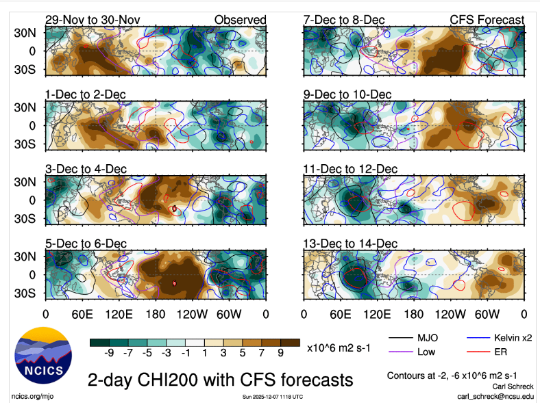
More than likely but its correcting itself recently on the RMMS,if you noticed a couple days ago its RMMS showed moving into the MC back into the NH in about 10 days doing basically the cycle,kinda fast dont ya think -
December 2025 Short/Medium Range Forecast Thread
jaxjagman replied to John1122's topic in Tennessee Valley
The MJO is at the bullseye of the COD today,but whats been happpening the last couple is semmingly whats going on into the WP and MC from Rossby/Kelvin Waves,just really getting destructive interference,RRMS which show it climbing back out into the NH,but its already there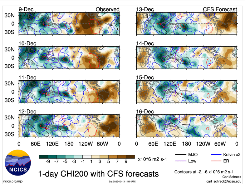
-
December 2025 Short/Medium Range Forecast Thread
jaxjagman replied to John1122's topic in Tennessee Valley
URGENT - WEATHER MESSAGE National Weather Service Nashville TN 607 PM CST Fri Dec 12 2025 TNZ005>011-023>034-056>066-075-077>080-093>095-130700- /O.NEW.KOHX.CW.Y.0005.251214T0600Z-251214T1800Z/ Stewart-Montgomery-Robertson-Sumner-Macon-Clay-Pickett-Houston- Humphreys-Dickson-Cheatham-Davidson-Wilson-Trousdale-Smith- Jackson-Putnam-Overton-Fentress-Perry-Hickman-Lewis-Williamson- Maury-Marshall-Rutherford-Cannon-De Kalb-White-Cumberland-Bedford- Coffee-Warren-Grundy-Van Buren-Wayne-Lawrence-Giles- Including the cities of Woodbury, Mount Juliet, Crossville, Manchester, Linden, Dickson, Kingston Springs, Lobelville, Allardt, Dover, Franklin, Springfield, Smyrna, South Carthage, McEwen, Centerville, Carthage, Celina, Cookeville, Pulaski, Clarksville, Waverly, Columbia, Clifton, Tullahoma, Coalmont, Gainesboro, New Johnsonville, Lafayette, Tennessee Ridge, Smithville, Altamont, Ashland City, Gordonsville, McMinnville, Lebanon, Nashville, Gallatin, Shelbyville, Brentwood, Lewisburg, Spencer, Sparta, Livingston, Erin, Byrdstown, La Vergne, Hartsville, Waynesboro, Goodlettsville, Hendersonville, Lawrenceburg, Murfreesboro, Jamestown, and Hohenwald 607 PM CST Fri Dec 12 2025 ...COLD WEATHER ADVISORY IN EFFECT FROM MIDNIGHT SATURDAY NIGHT TO NOON CST SUNDAY... * WHAT...Very cold wind chills as low as 1 below expected. * WHERE...A portion of Middle Tennessee. * WHEN...From midnight Saturday Night to noon CST Sunday. * IMPACTS...Wind chill values can lead to hypothermia with prolonged exposure. -
December 2025 Short/Medium Range Forecast Thread
jaxjagman replied to John1122's topic in Tennessee Valley
But if the blocking isnt more into the AK but more Western AK and into Siberia like the GEFS shows, assuming this is even right right,its not a cold look,you probably be seeing boundaries stalling out in NA somewhere and not your typical 1-40 and if the 850 V-winds kick up its probably more severe than winter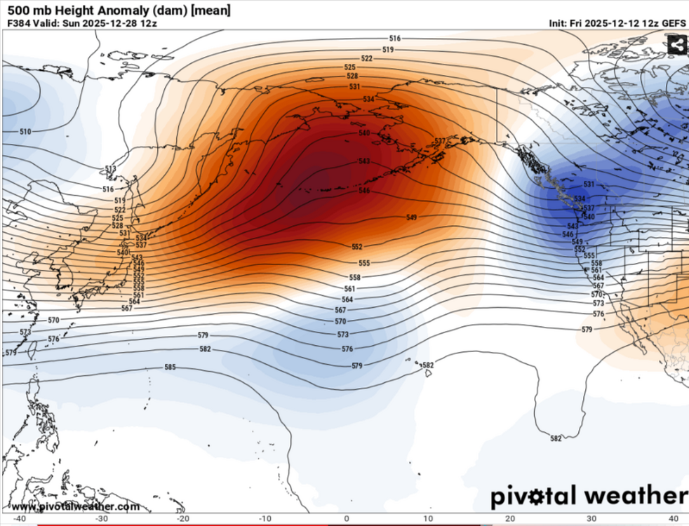
-
December 2025 Short/Medium Range Forecast Thread
jaxjagman replied to John1122's topic in Tennessee Valley
Just saying, here in Mid Tn,during NINO'S we can have destructive ice storms compared to NINA.Its really rare in a NINO winter to not see ZR or IP fall underneath SN and not just all SN.We've had in the past I.E in the 50's and 90's some destructive ice storms in MID TN.,during a NINO,for what ever reason NINA seems to bring late season snow here that falls at night/early morning and melts during the day,this is always late into winter early spring.But i'm not saying it cant snow,its winter,just the odds are it might not happen -
December 2025 Short/Medium Range Forecast Thread
jaxjagman replied to John1122's topic in Tennessee Valley
NINOS,not NINAS.I'm not saying it wont snow but chances are better for you guys than us,it should flip next year -
December 2025 Short/Medium Range Forecast Thread
jaxjagman replied to John1122's topic in Tennessee Valley
Like always in a NINA it seems,we see some flakes.If it snows it will be in March where it screws up severe -
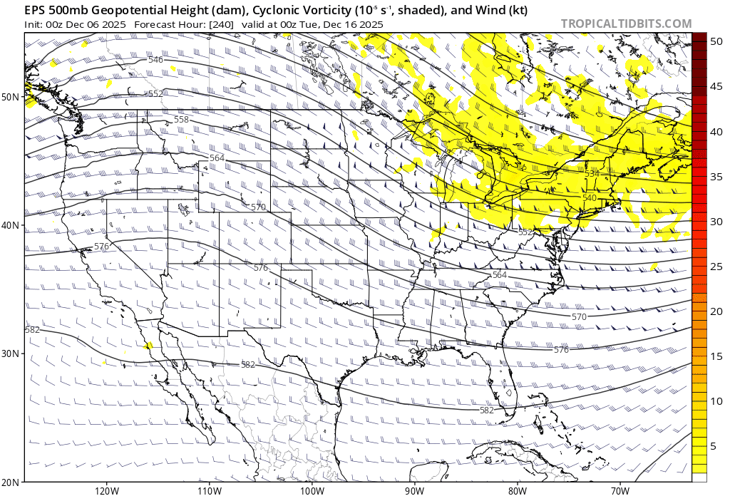
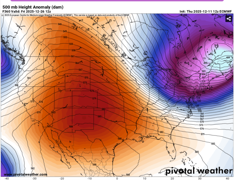
This basically shows the AR getting shifted from the NW into Cali,is this NINA or NINO...LOL
-
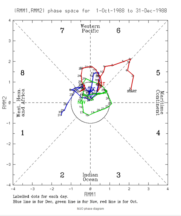
But 1988-89 was a mild winter just as well
-
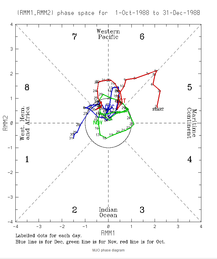
Since the models showed 1988,went back to look at the MJO IN 1988,it did some weird shit also,but this was a strong NINA unlike this year,no worries Jeff,i dont share anything here on this board unless you say i can
-
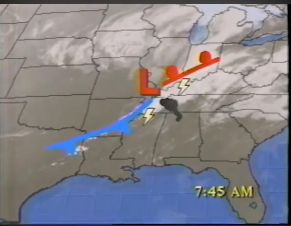
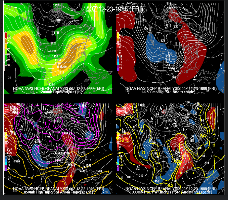
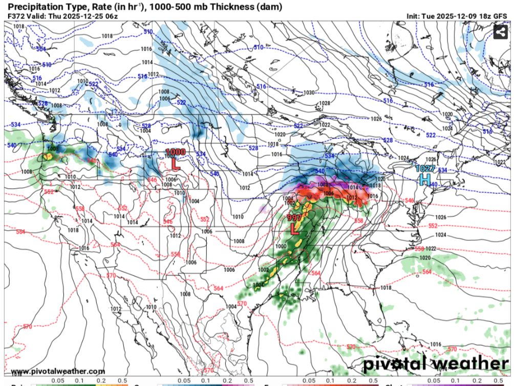
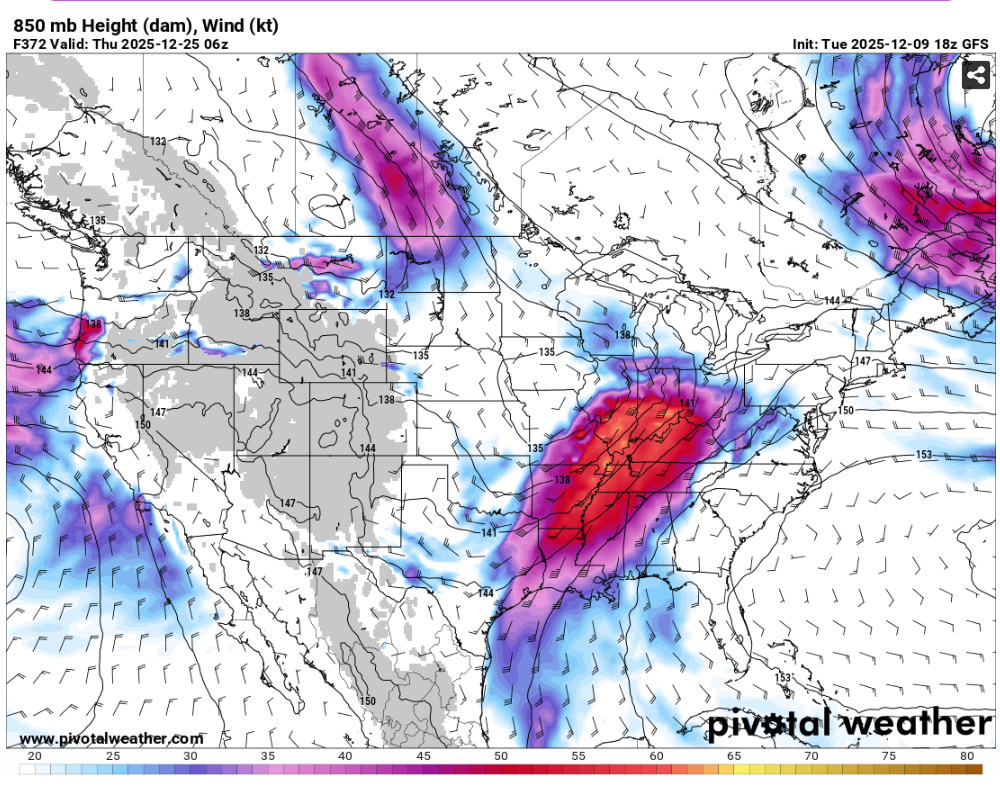
Went back and looked at the reanalysis maps of the Dec Christmas Eve tornado in 1988 in TN to see if that was possible with what the models seemed to hinting at a couple days ago,i used the day before,guess four words should be noted"GOOD LUCK WITH THAT" This pattern we are in is just like we seen last year when we was off to a fast start but collapsed when the blocking into the Western Aleutians/Being Sea set in after the tornado outbreak in March this year All this does is pull the JS further northward makes the severe shift up into the OV,in which is what we seen CIPS yesterday morning had some good analogs for tornadoes around Christmas from the LMV into the Mid South,but the models yesterday afternoon crapped that out building the subtropical ridge further northward Still over 10 days out,this could always change again.We more than often get severe before cold in the cold season.I.E the severe outbreak last winter where Vortex is at in MS. in late Dec

-
December 2025 Short/Medium Range Forecast Thread
jaxjagman replied to John1122's topic in Tennessee Valley
Euro the last couple runs has been showing signs of the Subtropical ridge moving out west,maybe its seeing something the other models arent seeing right now,dunno.But right now it dont seem to have much if any support
-
December 2025 Short/Medium Range Forecast Thread
jaxjagman replied to John1122's topic in Tennessee Valley
Kinda looks like Christmas eve,1988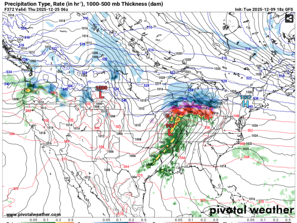

-
December 2025 Short/Medium Range Forecast Thread
jaxjagman replied to John1122's topic in Tennessee Valley
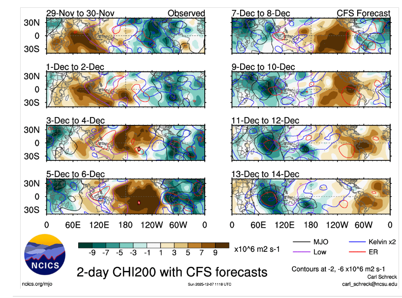
GTH Outlook Discussion Last Updated - 12/09/25 Valid - 12/17/25 - 12/30/25 Following a very high amplitude Madden Julian Oscillation (MJO) propagation across the Pacific at the end of November, the intraseasonal signal has rapidly weakened as it crossed the Americas and Atlantic in early December and now resides within the unit circle. The strong MJO event was the result of constructive interference between the MJO itself and Kelvin Wave (KW) activity which have become more decoupled in recent days. Long range dynamical model ensembles depict the RMM-based MJO signal generally remaining within the unit circle, with some re-emergence into the Western Hemisphere around the end of week-2. While the GEFS and ECMWF show this evolution to some degree, the CFS is the most robust in its depiction of a more coherent loop of the RMM-based signal which comes out of the unit circle in phases 7 and 8 later in December. Velocity potential filtering indicates a very fast moving enhanced convective signal circumnavigating the globe during the next 2 weeks, despite the lack of an RMM-based signal appearing over the Eastern Hemisphere. However, an experimental projection of objectively filtered KW activity in phase space reveals a continuously circumnavigating signal, which at times constructively and destructively interferes with lower frequency modes. This makes for a rather complex and low confidence Global Tropics Hazards Outlook and is based mainly on La Nina composites and some consideration of dynamical models. -
December 2025 Short/Medium Range Forecast Thread
jaxjagman replied to John1122's topic in Tennessee Valley
We'll know more in the next couple days where the MJO is going,now is when its getting destructive interference from Rossby/Kelvin Waves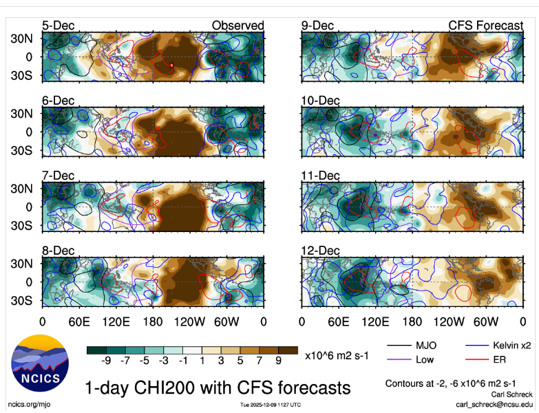
-
December 2025 Short/Medium Range Forecast Thread
jaxjagman replied to John1122's topic in Tennessee Valley
-
Thats what it seems like to me anyways

-
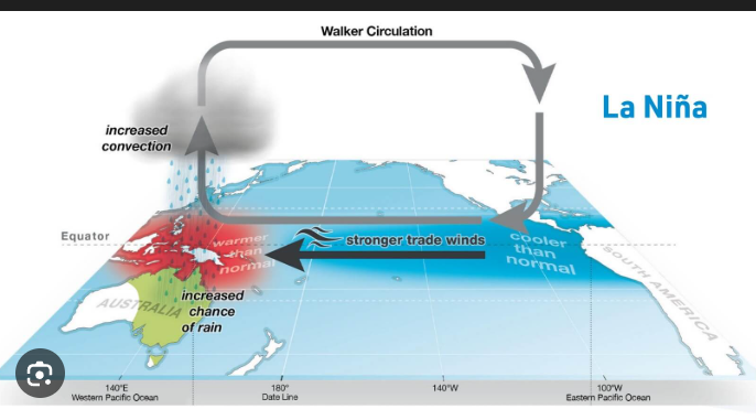
It might be with the Walker Circulation starts to strenghten,this is why you see the ensembles pull the JS much further north and basically traps the cold air up North in the long range in a NINA
-
December 2025 Short/Medium Range Forecast Thread
jaxjagman replied to John1122's topic in Tennessee Valley
I mean basically this is what we are seeing if you look towards Eastern Aussie land,not saying we will torch but its not gonna get that cold,cold air is gonna be trapped in Canada,Upper Plains.thumb.gif.1f7dee41e2c9a7f456fa10c724457ed2.gif)
-
December 2025 Short/Medium Range Forecast Thread
jaxjagman replied to John1122's topic in Tennessee Valley
It dont look very cold cold to me in the long range,this is in part due to the Walker Circulation ,when you see these strong EWB'S this strenghtens the Walker circulation and pushes the Jet Steam the jet more Northward in winter time during LaNina,in summer time we can see droughts in our parts,which is what we seen this summer,this is what you seem to be seeing right now with the ensembles long range
-
December 2025 Short/Medium Range Forecast Thread
jaxjagman replied to John1122's topic in Tennessee Valley
Record low on Deb 14 in Nashville was 6 degrees back into 1917,so that would break our record if it were to be correct -
December 2025 Short/Medium Range Forecast Thread
jaxjagman replied to John1122's topic in Tennessee Valley
Sure looks like the MJO is getting into the IO/Maritime No doubt about that,,big Artic High moving down from the Upper Plains -
December 2025 Short/Medium Range Forecast Thread
jaxjagman replied to John1122's topic in Tennessee Valley
Ensembles are going Zonal in the long range,not a warm look but its not cold either,very little QPFS,probably the only hope would be a bowling ball if it could manifest any cold with it I'm starting to wonder if the CFS is more right with the RMM'S,its been showing it going into WP the last several days,now its showing another Kelvin,Rossby into the WP towards the end of the year and crapping out there,we'll see if it keeps showing this.
-
December 2025 Short/Medium Range Forecast Thread
jaxjagman replied to John1122's topic in Tennessee Valley
Congrats bro !! -
December 2025 Short/Medium Range Forecast Thread
jaxjagman replied to John1122's topic in Tennessee Valley
But you should see a definite warm up past the Mid of Dec,probably not brutal but AN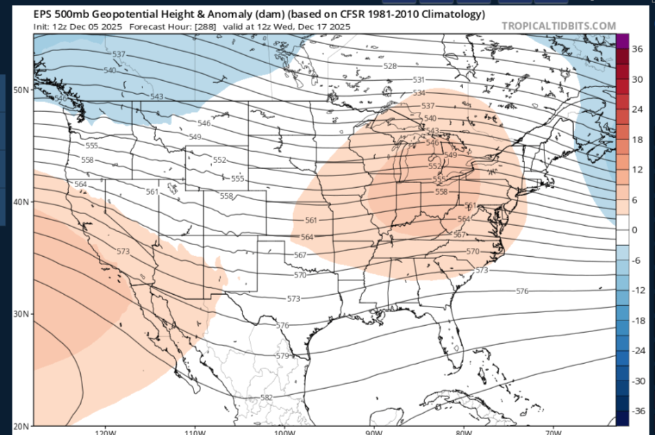


.gif.469c76a92091bafca7a10cb6e4bf2c4e.gif)