-
Posts
8,301 -
Joined
-
Last visited
Content Type
Profiles
Blogs
Forums
American Weather
Media Demo
Store
Gallery
Everything posted by jaxjagman
-
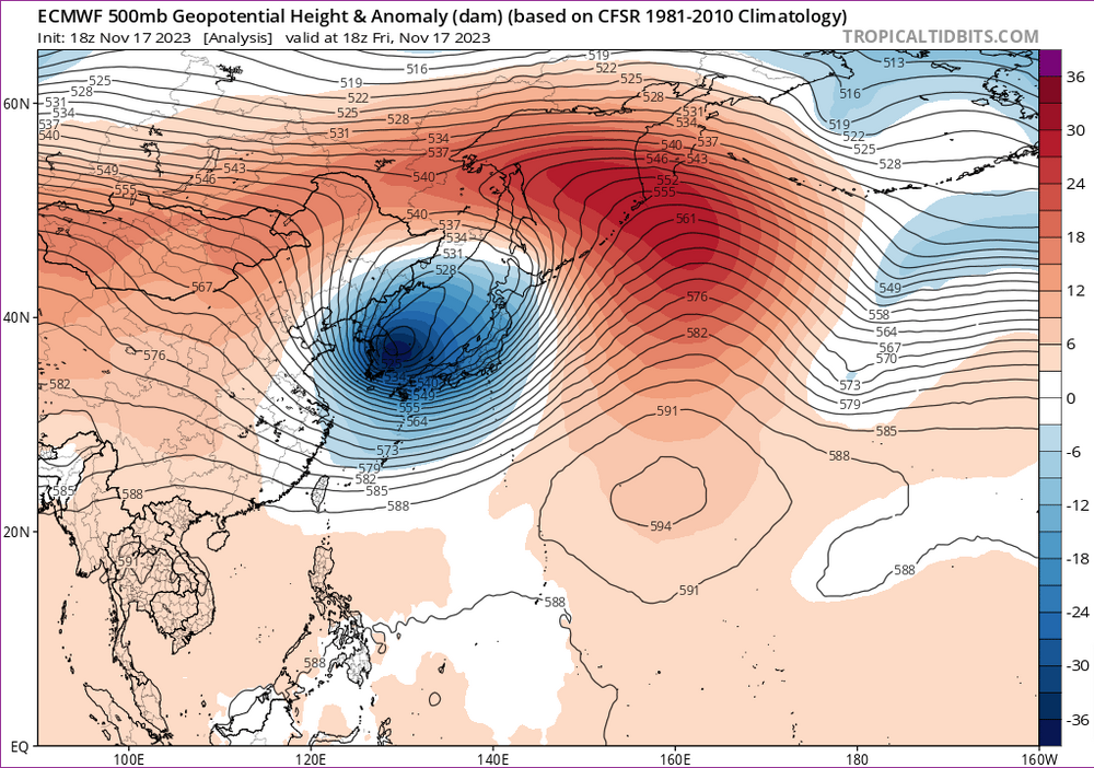
Wouldnt surprise me if the models get even colder post Thanksgiving,this was yesterday in East Asia,maybe we can get more moisture with a stronger CF that kicks in with a stronger STJ than the models are showing now for some thunderstorms,of course we need rain with thunderstorms or that could promote more wild fires..lol.Man we need some rain
-
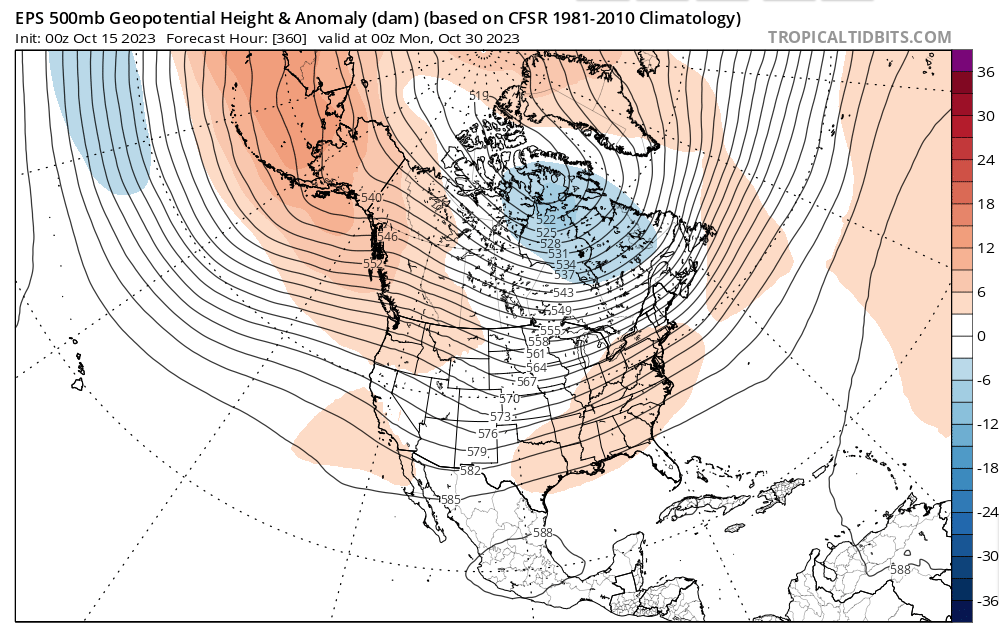
Really like to see the CFS right,this is a cold signal for us as we head towards Christmas into Jan,to me right now we are gonna get maybe BN around Thanksgiving and a potential warm up as we head into Dec
-
Meh,Euro long range even backs up what the CFS is showing,I'm with John tho,id rather have BN in Nov but this dont look that good right now
-
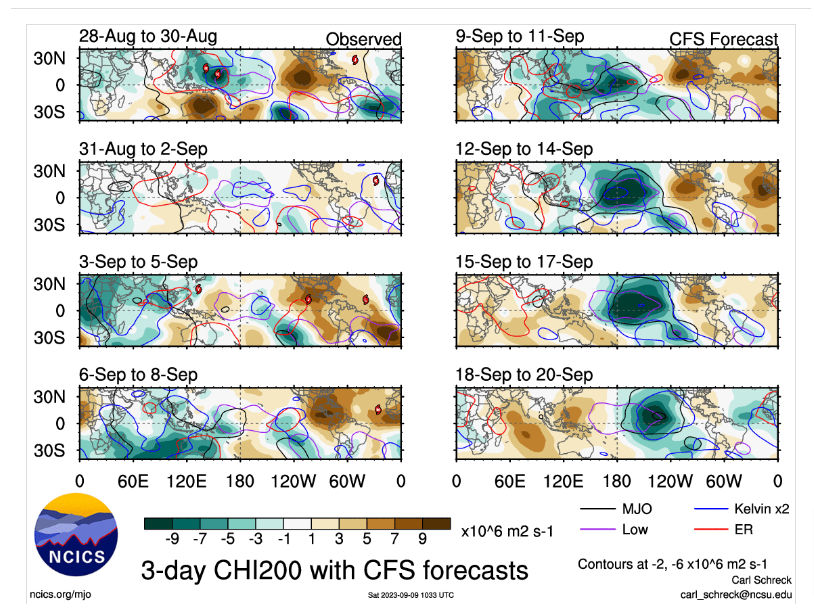
Not sure we will see that into Nov John,CFS the last few days wants to strengthen the MJO around the IDL into Nov,thats a typical SER signal which could be well into Nov,i know this is at the end of Oct but still,think we could see the same into Nov
-
Yeah guess we can say that was a bonus token with the rains recently.MJO is out of whack with Nino right now,pattern with the MJO you'd think there would be trough west not east upcoming,maybe we will get a cold front that produces some rain before it breaks down,dunno
-
Aluetian Low should be ongoing mainly,some signs its gonna get broke down as we head towards Halloween.Drought conditions should worsen the next couple weeks until it does.Really wanna see a more Western based Aluetian low as we get into Dec and especially into Jan,Jan could be more sliders down into Alabama,but a more Eastern could possibly mean severe not winter.But that is to far out to even speculate right now
-
The MJO is moving faster it seems but going into a more favorable cooler pattern.East Asia has a trough going through in a couple days and height rises into East China,we should be starting to see possibly a much cooler pattern as we head into next weekend.GFS seems to be to fast,i like the Euro myself as we get into next weekend
-
lol...yeah major brain fart,thx for calling that out
-
This seems to be shaping up to possibly a cross between the strong 2015-2016 and 1995-1996 ElNino.The thermocline is starting to really warm the past several days in region 3.4,looks like a potential to be a strong ElNino basin wide,we dont do very well in our parts in recent history but the jet gets suppressed and can bring bowling balls into our region just like 2016 in Jan Nashville got almost "9 of snow so it dont really mean it will be a snooze fest winter.Both the dates above also had tornado outbreaks in late Feb.plus in 1996 EARLY FEB Sparta./Crossville dipped down to around -20F,no telling what this winter will bring,maybe someone will get rocked. I took this from MJO812,so credit to him,just something to read in this boring pattern right now https://www.severe-weather.eu/long-range-2/winter-2023-2024-forecast-polar-vortex-el-nino-qbo-strong-impact-cold-weather-united-states-canada-europe-fa/
-
Maybe we will get that as we get into Oct,seems like the MJO might show its face by then as it heads towards the WP.This could or should get the tropics going into East Asia
-
MJO has some weak signals upcoming but could be going back into the WP,thats a SER signal as we get into Oct.Seems like the CFS is seeing this as well if you look into Africa{maybe a suppressed signal as well) other than timing.But thats a decent KW fixing to pass the IDL.the thermocline between 150W-120W has really been warming lately,this could really warm up Nino 3 pretty much,its already the warmest region right now
-
Really strange you see a tropical storm hit Cali,happened like 84 years ago.I dont think id trust any model into the long rangre,not right now anyways
- 295 replies
-
- 3
-

-
- severe weather
- frosts
-
(and 5 more)
Tagged with:
-
URGENT - IMMEDIATE BROADCAST REQUESTED Severe Thunderstorm Watch Number 641 NWS Storm Prediction Center Norman OK 135 PM CDT Sun Aug 13 2023 The NWS Storm Prediction Center has issued a * Severe Thunderstorm Watch for portions of Northern Alabama Northeast Mississippi Middle Tennessee * Effective this Sunday afternoon and evening from 135 PM until 800 PM CDT. * Primary threats include... Scattered damaging wind gusts to 60 mph possible SUMMARY...Storms are expected to continue to intensify across the region with a linear cluster evolving, with damaging winds as the primary severe hazard. The severe thunderstorm watch area is approximately along and 80 statute miles north and south of a line from 60 miles northwest of Muscle Shoals AL to 60 miles southeast of Nashville TN. For a complete depiction of the watch see the associated watch outline update (WOUS64 KWNS WOU1). PRECAUTIONARY/PREPAREDNESS ACTIONS...
-
Mesoscale Discussion 1981 NWS Storm Prediction Center Norman OK 1153 AM CDT Sun Aug 13 2023 Areas affected...Mid-Mississippi River Valley into the Tennessee Valley Concerning...Severe potential...Watch possible Valid 131653Z - 131900Z Probability of Watch Issuance...40 percent SUMMARY...An MCS moving across the mid-Mississippi River Valley will likely see new re-intensification through the early afternoon hours. This will pose a threat for damaging to severe winds downstream. Trends will be monitored for possible watch issuance. DISCUSSION...A lingering MCS moving out of northern AR has gradually become outflow dominant per KNQA radar imagery over the past few hours. However, over the past 30-60 minutes new convective towers are noted in IR imagery and lightning data, developing along/just behind the gust front as it approaches the MS River. Further re-development and/or re-intensification of the line appears probable through the early afternoon as the MCS approaches a regional buoyancy maximum over northern MS to western TN (MLCAPE values between 2000-3000 J/kg and rising as temperatures warm into the low 90s). Deep-layer flow over the region is meager with the KNQA VWP and 12 UTC BNA sounding sampling mid-level winds between 20-30 knots. This suggests that storm organization/longevity may be limited, but convectively-augmented (and poorly-sampled) mid/upper-level winds in the vicinity of the attendant MCV over northeast AR and the MO bootheel may support adequate deep-layer shear for a more organized/persistent severe threat. While confidence in favorable kinematics is somewhat low, a downstream damaging wind threat appears likely across western to middle TN and adjacent portions of KY, MS, and AL given the ample buoyancy. Trends will be monitored for possible watch issuance. ..Moore/Guyer.. 08/13/2023
-
Some of the short range models has been showing the MCS crossing the river right now falling apart before it reaches middle and eastern Tn,they've been pretty bad as of late,so far it seems to be holding together,pwats are around 2" here so it could be a good soaker,thunderstorms in middle and east Tn in a few hours
-
I was thinking the same basically,its been warm but the humidity has been bearable,the past few weeks could have been much worse.Plus as long as ive been living in Tn this might be the best severe ive seen with plentiful MCS action this summer so far
- 295 replies
-
- severe weather
- frosts
-
(and 5 more)
Tagged with:
-
- 295 replies
-
- 1
-

-
- severe weather
- frosts
-
(and 5 more)
Tagged with:
-
Think hes talking about his parts and yes some parts in the Valley has escaped the brutal warmth,you must be further south/SW where i can understand where you are coming from.
- 295 replies
-
- 1
-

-
- severe weather
- frosts
-
(and 5 more)
Tagged with:
-
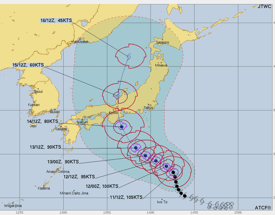
Not sure.But right now it looks like Typhoon "LAN" is gonna hit Japan then track into the Sea of Japan where it gets absorbed by a cold front/boundary.After that a ridge builds into East Asia.Seems possible that we see a ridge build into our parts possibly around into next weekend give or take,seems like what the models are hinting at right now
- 295 replies
-
- severe weather
- frosts
-
(and 5 more)
Tagged with:
-

Fall/Winter Banter - Football, Basketball, Snowball?
jaxjagman replied to John1122's topic in Tennessee Valley
Oh man,read this earlier but didnt have time to comment.Was wondering why wasnt posting now i see why.My prayers are with you bud -
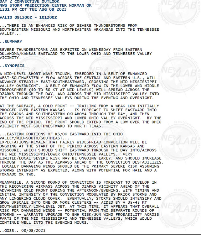
Tpmorrow has been upgraded Ozarks to Mid South to a enhanced
-
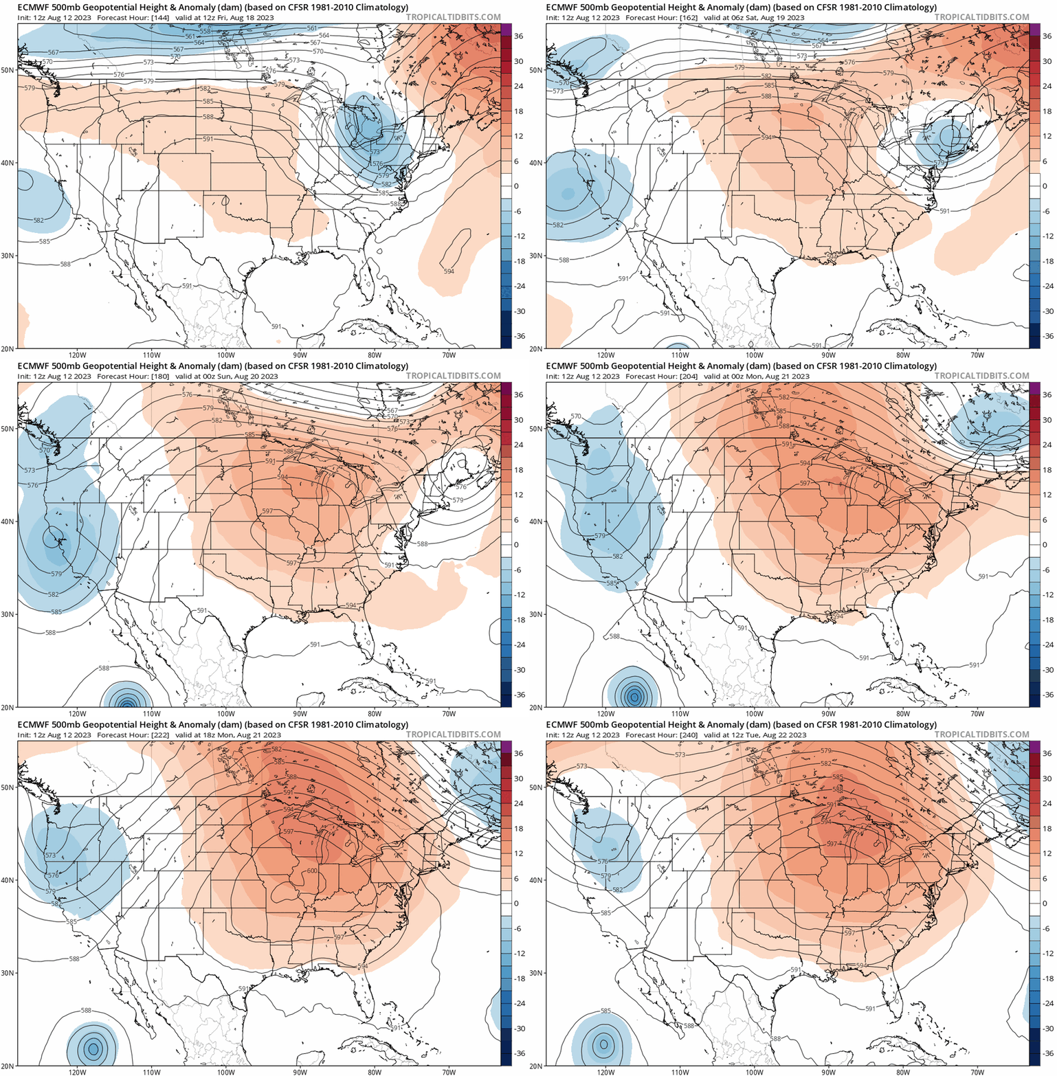
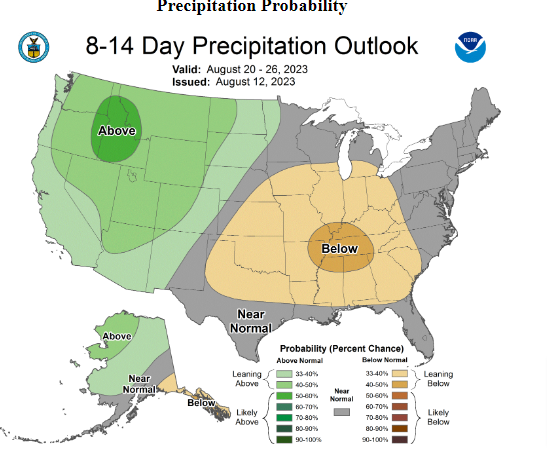
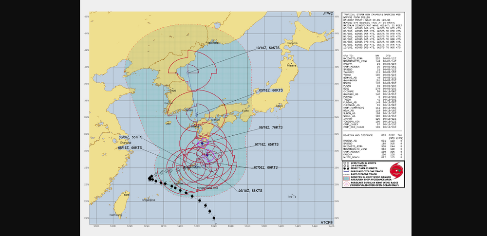
KHAHUN,is a pretty amazing storm,just basically stuck in no mans land with no steering current to kick it.Today the Euro shows it going into South Korea around Mid week finally,tho this could change.This pattern if this storm gets into Korea/Sea of Japan should set up a +PNA.Think we could see once again the potential for a MId Level Ridge build back up to our SW,this would give us a decent shot at MCS action as we head towards next weekend and into it.Unless the models change,we are fixing to get possibly into a real wet pattern in several days '
- 295 replies
-
- 3
-

-
- severe weather
- frosts
-
(and 5 more)
Tagged with:
-
Yes,i agree.Our lawn looks rather nice compared to summers past,some brown patches here and there but over all,not bad for summer.Rain chances will be on the rise as we get further into the week.Euro shows some unseasonable high PWATS as we get into the week,se we'll see.
- 295 replies
-
- 2
-

-
- severe weather
- frosts
-
(and 5 more)
Tagged with:


.png.0c92e847468fe2a21abb5c6fd854904f.png)
.png.f6d4f463c8d297514a101d53d6d1d70b.png)

.gif.57751a1edf0e04f8d376c53e74955b9f.gif)
