

nrgjeff
-
Posts
4,261 -
Joined
-
Last visited
Content Type
Profiles
Blogs
Forums
American Weather
Media Demo
Store
Gallery
Everything posted by nrgjeff
-
Fun! Anybody flying into Knoxville today?
-

December 2020 Medium/Long Term Pattern Discussion.
nrgjeff replied to John1122's topic in Tennessee Valley
Took last week off and totally checked out. I'm so far behind in this thread that it's hopeless. However I guess that's a good thing if the pattern is worth discussing. ECMWF weeklies followed the CFS with now a third cold week, counting this week, week 2 and week 3. Now we are in -ABNA with some +PNA which is cold. MJO is in a decent phase. While we have a week TC attempt near Sri Lanka in the Indian Ocean, the vast majority of convection is in colder phases of the West Pac. -
Awesome pictures this page! My November 30 ob is not worthy of the thread. At 3:55 pm Eastern snow flurries reached East Brainerd, Chattannoga, Tenn. So light it looks less like snow, and more like the Upside Down from Stranger Things.
-
Fall/Winter Banter - Football, Basketball, Snowball?
nrgjeff replied to John1122's topic in Tennessee Valley
Euro ensembles came around last night. Majority of members have a closed low in the 11-15 day. Weenie mode activated! ! 11-15 day forecasts are disputed and often change. Prepare for disappointment! -
December 2020 Medium/Long Term Pattern Discussion.
nrgjeff replied to John1122's topic in Tennessee Valley
Well hello there ECMWF weeklies! And I see you CFS weeklies. Can they be right? Well if the MJO actually progresses, it would be supportive going into cooler phases (Southeast US). Multi-month +ABNA background is slightly below normal heights here, but AN everything Canada. A cooler version of that (progged normal heights Great Lakes) would verify cold down here. Both weekly products have that colder look weeks 3-4. AN precip East Coast with BN precip Mid South is not a bad look. Remember snow carries lower liquid content. That AN precip can stay southeast of here as rain. No promises. It just feels nice to write about something other than blowtorch or covid. BONUS: CFS weekly snow charts get the Mid South week 3 or 4 depending on which presentation. PATTERN recognition is good for the higher elevations too (Mountains, Plateau). Then Christmas severe verbatim. ! week 5-6 forecasts are disputed. -
December 2020 Medium/Long Term Pattern Discussion.
nrgjeff replied to John1122's topic in Tennessee Valley
IIRC my first winter here, November was mild until it got cold after Thanksgiving, and culminated with a good January snow. Oh yeah White Christmas too 2010 before that January 2011 snow. Past performance will not help future results, lol! Oh crap April 2011. Nope! Even me the severe wx enthusiast. Nope! OK getting serious, since this is the true December thread, I figure it'll take a few cold fronts to set the table for anything after mid-December. Except for at elevation, I doubt much happens through first third of December. -
Eric Webb tees up 38 and rain for Chattanooga! Friday was our kid's last day in class. We pulled to online learning between Thanksgiving and Christmas. Data is pretty clear. Pattern recognition for the forecast is also. I'm mainly talking about the Chattanooga forecast, lol!
- 168 replies
-
- 2
-

-
- leaves changing
- temperatures
- (and 2 more)
-
December 2020 Medium/Long Term Pattern Discussion.
nrgjeff replied to John1122's topic in Tennessee Valley
Ensembles all followed cooler overnight. Euro, GFS, Canadian. I don't look at the teleconnections weekends. More on Monday. Fingers crossed! -
I agree the window for cold (rain Chattanooga) will be brief. Looking after Thanksgiving. The pre-Thanksgiving system should be warm. I'm not buying severe though. Post-Thanksgiving system is cooler but lacks a cold air connection. Maybe the higher elevations. By then I'll be focused on college basketball. Finally! Looking into early December I see nothing interesting. Even if it's not as warm as shown, the +ABNA won't quit.
-
The Bering Sea giveth and taketh. If we keep a longer wavelength and +ABNA the Bering Sea trough is actually bearish. Above normal heights and temps northeast China and Canada. Mild much of Eastern China and the Eastern USA. Sorry I'm so bearish today. I do agree with some back door front action after Thanksgiving. Helps northeast Tenn. You know my forecast for KCHA, lol!
- 168 replies
-
- 2
-
-
- leaves changing
- temperatures
- (and 2 more)
-
Wild Speculation for Winter 20 -21
nrgjeff replied to Holston_River_Rambler's topic in Tennessee Valley
Unfortunately the Wall St. Journal does not offer a comparison to Mt. Pinatubo 1992 which was the last aerosol event to actually impact temperatures. Carry on with much above normal temps this winter. Strato vortex is really locked up tight. -
I share some of Fred's thoughts and concerns above. However I'm hoping it's not wall-to-wall severe. While I love a good Pains chase, I really don't like this crap in Dixie - especially trying to shelter my family at 1am. The pattern Fred describes is my secondary pattern for the winter and spring outlook. Trough comes through the Plains. Depending on the lingering SER severe weather would be favored in Hoosier Alley, Dixie Alley, or both. He covers the hemispheric situation. I'm talking the synoptic troughs. We saw this at times in October, but without much incident. Same deal in late winter or early spring would be impactful. Fortunately my primary pattern is the current one, influenced by the stubborn +ABNA. Warm northeast China. Trough Aleutians, Bering Sea, sometimes GOA. AN heights and temps much of eastern Canada. AN stuff bleeds into Great Lakes USA. Leaves the Southeast near normal heights. Temps would be above, but no big systems or low-amp troughs with moisture. Could be low-amp cloudy drink more coffee days. I'm one of the severe wx enthusiasts here, but I also got a family here and know we have some members who hate severe wx. While I do agree spring will be active, I have no reason to forecast anything historic. To quote Spann, severe wx is normal and we'll get through it.
-
Agree with Holston above. Nothing encouraging here https://psl.noaa.gov/map/clim/glbcir.quick.shtml where I check for pressure and heights. Arctic is locked up. All weekly products are a blowtorch as well. Eh, I'll take sunny at any temperature.
-
Let's go a head and issue a Slight Risk for Grumpy Bunch of Posters. Upside is Moderate but maybe we can still salvage basketball. Actually the ensembles are Enhanced Risk already. Cancelled the cold, other than brief fronts with near seasonable cold. Guess just go with the weeklies.
- 168 replies
-
- 3
-
-
- leaves changing
- temperatures
- (and 2 more)
-
Fall/Winter Banter - Football, Basketball, Snowball?
nrgjeff replied to John1122's topic in Tennessee Valley
Welcome @BrookeM and enjoy the forum. We have a Garden thread. Can anybody help with the irrigation question above? All I know how to do is kill plants with my brown thumb, lol! In true banter, I lament the KC Chiefs are once again not on TV here. On the bright side their defense can't give me a fourth quarter heart attack on TV. -
Fall/Winter Banter - Football, Basketball, Snowball?
nrgjeff replied to John1122's topic in Tennessee Valley
Welcome @Blue Moon and jump right in! This sub-form Tennessee Valley of American Weather is one of my favorite places for weather discussion. -
1. The post Thanksgiving cold looks brief now. Combo of MJO and NWP. 2. The solar flare means go to Alaska and chase the Aurora. Single flare doesn't mean much more. 3. If we go into split flow after Thanksgiving it could be cloudy. Please no!
- 168 replies
-
- 1
-

-
- leaves changing
- temperatures
- (and 2 more)
-
Numerical models are trying to go colder after Thanksgiving. This is after the seasonable front next week. I'm talking 16-30 day hints with the MJO. MJO is going to be fickle for a few days though. Tropical Cyclones are active and or forecast in the Western Pacific and Indian Oceans. TCs typically create volatility in MJO forecasts.
- 168 replies
-
- 4
-
-
-
- leaves changing
- temperatures
- (and 2 more)
-
Fall/Winter Banter - Football, Basketball, Snowball?
nrgjeff replied to John1122's topic in Tennessee Valley
Researchers are notorious for throwing up theory on Twitter with no operational forecast implications. I read tight polar vortex. That's a mild signal. Maybe I just see everything as warmer than normal winter news. Some folks were asking/hoping the fire smoke would be a useful aerosol. Probably not enough of it, believe it or not. 1. Anthony is really good at operational forecasting, but can't share directly, due to his job. 2. Butler is amazing and will share implications occasionally, but only in her own threads. -
Canada has above normal precip. If it's snow then it's a decent North American signal. However the Asian side sux blowtorch just like here.
- 168 replies
-
- 2
-
-
- leaves changing
- temperatures
- (and 2 more)
-
Chattanooga was lit this weekend. Enjoyed a couple nice local hikes.
-
Wild Speculation for Winter 20 -21
nrgjeff replied to Holston_River_Rambler's topic in Tennessee Valley
European Monthly charts are pretty warm most of winter. December has a small Southeast US cold cluster; but, the Western Canada source region is on fire. February and March are endless SER. Hopefully the overnight severe is up in Hoosier Alley. January appears to the best shot at a good secondary pattern. Clusters are below. The 48% has blocking and a path to deliver at least seasonably cold Arctic air. That'd do it! I'm assuming these are available to the public now. If not, please to not re-share. Certainly no commercial use. OK for academic use.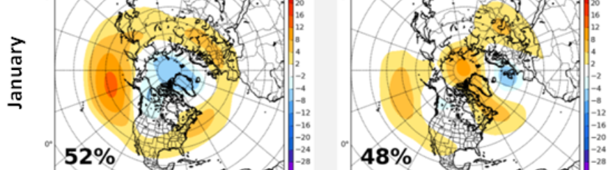
-
Veterans Day 2002: Now that's what I call Interesting! Though I can't find archived upper air charts. I infer from the orientation of the front that the trough was positively tilted, and still produced a High Risk. Do we laugh at the Euro and GFS or take that a little more seriously? I'll opine for real later this week.
- 168 replies
-
- 3
-
-
-
- leaves changing
- temperatures
- (and 2 more)
-
Fall/Winter Banter - Football, Basketball, Snowball?
nrgjeff replied to John1122's topic in Tennessee Valley
Actually @AMZ8990 my home barometer was sluggish. However I was too. Needed extra coffee. Four days overcast, or the pressure drop? Sun was nice by afternoon. Then the evening squall with CF almost impressed me. Usually don't get those with the Plateau slowing down things. It was just enough to remind me of a Plains cold front, though a milder version. Still, thumbs up! -
I was sleepy AS so maybe the pressure, lol. My home barometer is an old one so did not really keep up. I should upgrade. Couple Halloween decorations face-planted. We will rebuild.

