

nrgjeff
-
Posts
4,256 -
Joined
-
Last visited
Content Type
Profiles
Blogs
Forums
American Weather
Media Demo
Store
Gallery
Everything posted by nrgjeff
-
Old Hickory is itching for some action. Cooking boundary in May often produces. However the LLJ is DOA east of I-65. It's weak west of there. Probably would just maintain any MCS with straight line winds up to I-65. It's really not strong enough for tornadoes; but, you never know around a boundary in May. Pulse type thunderstorms are progged over here near KCHA. We've got zero LLJ out the window or on the models. These Cu are just sitting like in the middle of summer, no movement.
-
Brutal Mutual aid restoration crews have been so busy this year. We still have work going on in the EF-3 damage area of Chattanooga, basically rebuilding from scratch. However most everyone else was restored within 10 days after Easter. I'm still amazed at how quickly they rebuilt the main lines. Why can't road construction be that fast?
-
Looks like the real deal to me. Funny everything goes earlier than season this year. Nashville tornado along an east-west boundary in March seemed more like a May set-up. Now here we are with a quasi-derecho situation almost a month earlier than normal. I'm not saying it'll be a true derecho, but it's an MCS riding / sliding ESE on the nose of high CAPE (for early May) with moist southwest winds feeding the beast. Storms sinking south of, drifting away from, the upper-level wave may be what prevents the strongest scenario. Should be several damaging wind reports in Tenn. Hopefully nice shelfie pix are incoming.
-
That stubborn 3 region is killing my Plains plans. Agree the KW may cut SSTs but it's a tough area for MJO convection. Perhaps late May the new pulse in the IO will have more influence. Then for next winter hopefully not the dreaded warm version of Nina. I'm OK with sunny SER but the lack of snow is boring. Conundrum for sure!
-
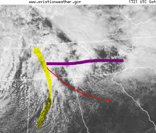
Though low level winds are veered off, today could be interesting in the Shelfie category along I-40 especially Plateau and points west. Winds surface to 850 all look similar west of south. However there's decent speed for May especially higher up. Good recipe for straight line winds with the CAPE building. Some CAMs have cells hooking into southeast Tenn. Others have things stabilizing from the main I-40 show and outflow. Finally there's the question about the main show/line east of the Plateau. Can it get to Knoxvegas? Cell and outflow interaction may determine how fast things stabilize this evening. At least we have something to track. We could use a break from tornadoes, so straight line wind is acceptable.
-
Yeah it just clouded up over both areas of surface convergence. Thundershowers are in progress, but it's not not energetic enough. The clouds just blossom on the loop. That'd be great in winter, but lol in spring. Also see Windspeed right above. Remember to read SPC discussions, even on the junk days, since it helps discern the good the bad and the ugly. Local office discussions often add more detail. Find it on weather.gov/mrx and the drop-down menu from forecasts to Forecaster's Discussion. Weather pattern turns incredibly boring after this. See y'all in a couple weeks, lol!
-
Dewpoints are way behind schedule compared to all 3 CAMs NAM/WRF/HRRR. North Bama dews are in the 50s; it's progged low 60s Td by this time 14Z. I was hoping for a repeat of Saturday structure; but, looks like no dice. Though the LLJ is screaming (and mixing down) it may be shunted east this afternoon. Thunderstorms will still develop. Two shortwaves are noted coming through the flow. The first is already into Georgia marked by mid-level cloud signature. Then we have new lift coming from Louisiana, marked by the ribs in the high cloud deck. Mid-levels will also cool with time this afternoon. Thunderstorms yes. Fireworks, probably not.
-
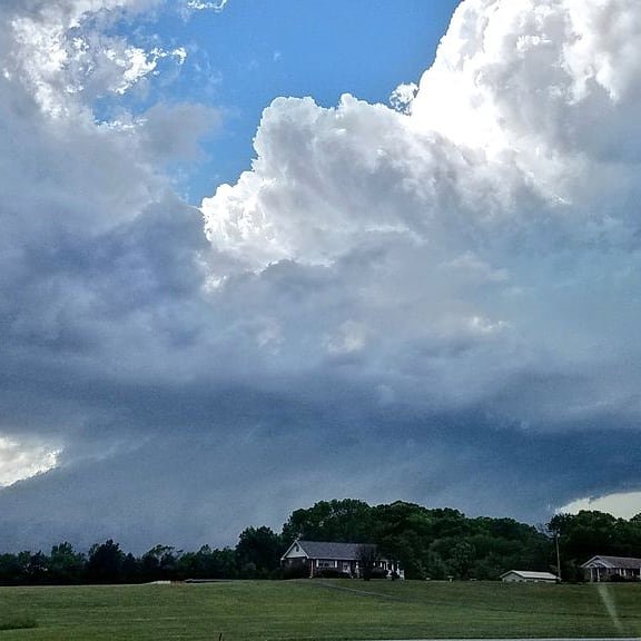
Always Cookville. Photos on Twitter look grungy though. Jives with lots of rain wrap around on radar up there. Documented this foot / beaver tail around Ooltewah, before following toward Etowah. No touchdown, I saw the base at times driving. This is where I could safely pull over. It was a low-top mini-sup with tilted updraft. No true wall cloud, but it's gorgeous.
-
That might be helpful for my Kansas concerns in May. Looking even farther ahead, though quite imprecise, another wave of convection is flaring in the western IO. It's behind the DL wave Jax writes about. I'm hoping my second wave is crossing Indonesia (MJO maritime sub-cont) about late May. By then I feel the SER will be attempting a return, probably more so than NWP shows out weeks 3-5. If Holston is camping out West, Rockies trough LOL. Could be the ol' chaser rose colored goggles, but it's all on the satellites covering the Indian Ocean. Cheers!
-
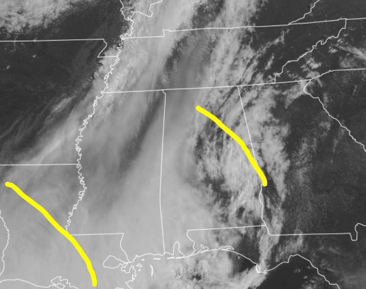
I agree with MRX above. Was that on NWS MRX page at one point? I saw it elsewhere. Meanwhile a triple point has pushed from Miss/Bama into southern Middle Tenn. Should continue over the Upper Plateau into northeast Tenn. Don't let the chart scare though. Still agree with only MRGL/SLIGHT risk thanks to pitiful dewpoints.
-
SPC Day 2 even mentions the Cumberland Plateau. Elevation puts it closer to the LLJ. So, I guess the Cumberland Trail is open?
-
Marginal. Saturday. That's a go! Of course it's garbage weak moisture return and all. However a surface trough and backed winds tracks through (during the daytime - what a novel idea!) Tenn. Could be low top, low probability, but decent visibility. So much for the latter on Thursday, lol! If the 12Z guidance is the same to more robust, Saturday might be a chase day. Um, urr, I mean, go to one of those State Parks that are opening.
-
Re: the Hanks video, I'm amazed the power stayed on. Traffic light appears to be working right after the tornado crossed the power lines; however, we only get a second or two of that before he moves. Later in the video power lines elsewhere are down. He is too close though. Tornadoes can and do rapidly/instantly widen. Bad move there. Moving on, today has a conditional Slight for parts of the Valley and Plateau. Is today Thursday? Anyway new development could be low top, low probability, but high visibility. And in the daytime - what a novel idea around here! Roger Edwards says it best. Here's our section of the 13Z Day 1. Severe potential still exists with a possible second episode, along/ahead of the cold front from the Tennesseee Valley region southward, but is very conditional. Substantial stabilization to near the Gulf Coast is associated with the leading MCS. Only a narrow back door of at least marginally favorable theta-e advection and related airmass recovery will exist to the west, which comes with offsetting influences: 1. Southwesterly near-surface flow ahead of the front will yield the best trajectories for theta-e recovery around the morning MCS outflow, but also contribute to relatively reduced low-level shear and convergence. 2. Any southerly to southeasterly trajectories from the MCS passage will be more convectively stabilized. (no dice there - me) Still, a narrow plume of favorable buoyancy may develop -- with MLCAPE ranging from around 500-1000 J/kg in the north where deep lift, cooling aloft and shear will be greatest, to around 2000 J/kg in the south under weaker ascent and shear. With uncertain coverage, duration and intensity of convection in this regime, the risk level is not as great as farther southeast, and should diminish markedly after dark.
-
I will sleep well tonight. Just checked the CAMs, and more important stability forecasts. Then Thursday looks veered off with lots of storms well to our southeast. Honestly I was checking radar and surface too much Sun. Apr. 19 - residual nerves after the April 12 tornado. Tonight/Thursday - like 4/19 - we're not even in Slight. Since I both agree with and trust the SPC forecast, I probably won't check as much this second time after. It's a process - even for a Met. Good thing for all of us on this forum, we have greater than average knowledge of this stuff. I'm not sure if knowledge is power, but it helps. Remember as the great James Spann says, tornadoes are rare.
-
I'm skeptical of the sig tor index this setup. Winds shear will be high, but the greatest turning will be GA/SC. Speed shear will be over Bama, but not as much turning. CAPE/LI will be high over Bama with clearing; but, the front will be racing into GA/SC. Believe the STI is over-blown, after drilling down the charts. If the short-wave was 12 hours slower, it'd be a bear of a day. Thankfully probably not for our Tennessee Valley. I am honestly worried about Georgia and South Carolina. This human puts the bullseye about a state east of the STP, and with a lower number.
-
Probably a trough West, endless SER. Note I'm still negative and jaded about weather right now. In all seriousness, that could be a screaming +NAO and jet stream. Winters are a total loss, even in a Solar Min.
-
The only time they are worse than in winter.
-
Wednesday night southwest flow apparently washed out any boundary. The veered off onslaught saved us from spinners. Then the 5% East Tenn. Wow it was obvious back around midday Wednesday that's not necessary. Might explain SPC. With all due respect, they've been way too model dependent the last couple seasons. Especially the amped up HRRR.
-
The good the bad and the ugly. Bad first: Tonight looks like an overnight event. The Good: I don't see enough turning (low or upper level) for a big tornado risk. Wind and hail yes, especially from sups. Instability could cause some gorilla hail Midsouth. Yeah we'll have some sups, but turning wind is not that bad. Helicity forecasts are up due to speed shear, but directional is meh. The Ugly: Forecasting an Outbreak Day 5 Sunday. Who knows? Maybe a Gulf Coast MCS will rescue all of us. I mean, it is Easter! Since we can't chase right now, might as well side with the Public and wish against severe.
-
It's probably usable NWP, even with some degradation. We been modelling 500 mb for over 50 years. The pattern is obviously quiet upstairs. Chaser be like, fine. Get the garbage pattern over with while we can't go out anyway. No matter what, I'm out of the field through April 30, or later if state level guidance goes longer.
-
SPC goes with a tornado watch that gets to KATL and all of the southern 'burbs. While the LLJ is a little veered, it is bringing in a moist fetch. Also surface winds are really backed on that retreating boundary. Regarding that LLJ, I've noticed southern Georgia can produce while a little veered off. I think most of the Atlanta metro is OK, some morning rain and the atmo should not recover / destabilize enough to get nasty later. South Georgia could have a day though.
-
Jonesboro tornado trolled all the Illinois and Iowa chasers. Thankfully nobody was killed, but news says some serious injuries. OK we get a break this week. Probably a good thing. Models saw the East trough last week, and it's in progress now. Next week could get active again. Convection is coming out of the Indian Ocean toward Indonesia (maritime sub-continent). Lead by the ECMWF all models are coming around to a West trough. Euro verbatim favors Plains/Midwest. Getting into April it could go north, south and/or both. I don't have any plan to chase anything beyond 2 hours. Dixie just isn't worth the drive, lol.
-
Gulf will also help severe season along. LOL the CFC flip flops on ENSO. Ahh, that spring predictability barrier.
-
Big changes since Sunday. Instead of Ohio River Valley jungle, we now have an outflow boundary in North Alabama and just south of KCHA. Still plenty of failure modes. A. Rain-out B. Veered off C. Capped (too little too late) D. Combo of 2-3 above E. Rather watch sports reruns Early season is prone to failures, which is of course good for the general public. That said I figure ENH is incoming. Obviously if something is close to KCHA I'll take a look. No chase greater than 2 hours though; so, I won't be visiting the chasable northwest Bama area today.
-
We got throttled March 2012. I've nothing much on this week. Veered off trash. Only turning is in the Ohio River Valley jungle. Back to NCAA Basketball reruns!


