

nrgjeff
-
Posts
4,256 -
Joined
-
Last visited
Content Type
Profiles
Blogs
Forums
American Weather
Media Demo
Store
Gallery
Everything posted by nrgjeff
-
I expect Tuesday will get an Outlook on Saturday morning or soon after. Euro remained consistent if not stronger. LLJ is a touch veered, but not like the last two systems. It's fortunately not backed like Super Tuesday either. Upper level winds are a given. Low level theta E (temps/humidity) will be a question. Even with all those caveats, if the Euro holds, one has to think Tuesday gets a 15%.
-
The Midwest can have it. Dixie had enough heartache for the season.
-
Link between COVID-19 and weather. Storm chasers enjoy cheap air fare to the Plains. No 14 hour drive! Oh wait, the actual storm chasing days. I forgot about that.
-
I got distracted watching stocks, lol! But yes, we have a severe weather problem in Tennessee tonight. So the models all have Missouri Boot Heel convection going into Kentucky. All clear? Hell no! Let's do some meteorology. First of all it's not moving northeast. It's moving due east. That'll anchor the boundary farther south than progged. Gee, that never happens. I am hoping the short-wave ejection will push the boundary to the TN/KY border. If not it's in danger of hanging up near I-40. Frankly breaks my heart to type this. Sometimes we science. Sometimes we pray. Anyway, the 850/925 mb charts look more veered than Super Tuesday. Do not expect a repeat. Still, just strong storms disrupt recovery. Psychological damage of just general thunderstorms can't be ignored. Shear will be worse up in Kentucky (or wherever the boundary settles out). Not Super Tuesday, but not a good night either.
-
Please do. Your local utility will like you. Thoughts are my own, lol! If we can keep air fare low through next winter, I see some Rocky Mountain skiing in the forecast!
-
Guess we can already go with another blowtorch winter 2020-21. Maybe the SER will be such a beast it keeps severe Midwest and Plains. Flash drought coming to a place near you.
-
Yes @Calderon is absolutely correct! @PowellVolz that's not a TDS. That is lofted debris carried into the forward flank. Also a sign of a violent tornado. Sure enough OHX finds EF-4 damage. Though the lofted debris signature didn't last as long, it has similarities to the Kansas City tornado last May. Middle Tennessee tornado itself might have lasted longer than the KC one. Have to look back at all that. At any rate, this Tennessee tornado was historical.
-
European weekly charts are ugly for severe wx the next few weeks. Great Lakes Ridge with Gulf Coast underbelly is replaced with more traditional East Coast ridge. +AO and -PNA spell more Dixie Alley trouble. I'm not rooting for this. Rather postpone to May Plains.
-
Low CAPE high shear events happen. Wait! This was not exactly that... I'm watching KPAH get the hail treatment about 5pm Monday. Back of my mind I know it's westerly flow aloft over a boundary - but a little early in the season for that set-up. Text my buddy a boundary rider is going off on PAH, but don't think too much about it. Cell weakens, and I start gearing up for Big Monday college basketball on ESPN. Wake up Super Tuesday to Middle Tennessee super tragedy on the news. WTF? Going back to Monday afternoon shear was never in question. I've written here many times, look for westerly flow aloft instead of that SSW flow junk. Nearly 90 degrees of turning was noted. 850 was a little veered, but upstream was deep moisture - count it as backed in Dixie. 925 mb was straight south and both increased going overnight - all forecast ahead of time! Surface of course had the notorious boundary related SRH. CAPE and instability was more complicated. Steep mid-level lapse rates were in place, but low-level CAPE was close to zero. Forecast soundings had the latter improving; but, I'm such a skeptic of those. Normally early season other rain is falling, and it remains stable. Well no rain was falling south of the boundary. Surface chart in retrospect shows an unstable airmass advecting in unfettered. Sure enough it arrived at the boundary in Middle Tennessee. LLJ strengthened. Alas the 2% TOR area was under the gun. CAMs actually had robust storms, but not necessarily a boundary rider beast. Old fashioned meteorology could have provided a more obvious heads up before the evening news. However, credit some local TV Mets for sounding the alarm on the evening news. Still, it's tough to overcome a 1am long-track cyclical damaging tornado. Dixie Alley is just so awful. It's either busted chases, or much much worse. The human suffering down here is cruel. At least the Vols cheered up Tennessee. https://davieswx.blogspot.com/2020/03/march-3-2020-double-digit-death-toll.html excellent article from Davies.
-
Flash Drought, but still humid AF and AN temps. Yuck!
-
ERTAF has begun! Cue up, It's the Most Wonderful Time of Year! Agree with them though, it looks benign for a while. Just as well until after the Final Four. Japan satellite shows the two Kelvin waves (MJO pulses) well. Also got a trough trying to dig into central China. Probably get a ton of MJO interference though. Though both sets of weekly forecasts appear on fire with the West trough, devil is in the details. Soft underbelly Deep South hints split flow chaos.
-
Super Tuesday severe setup is now hampered by sharp divergence between the progressive GFS and slower Euro. Truth may end up in between, but mostly toward the Euro. As for north/south tracking, EC Op surface low is buried in the Deep South. However the vast majority of its EPS (Ensemble) members have surface lows farther north including the Midwest. That's more severe and more heavy rain here. No wind fields analysis since the whole thing is a cluster now. One can imagine the north members have better wind fields. South members are cool rain. Heck now we can't even pick out the day or the place. Tuesday Wednesday or Thursday anywhere from the Delta to the Carolinas; but, probably only one day where everything comes together for severe in just a couple states. Flooding rain is a different story in a different thread.
-

TN valley heavy rain/flooding week of whenever
nrgjeff replied to janetjanet998's topic in Tennessee Valley
Last time the Euro won this battle. It's less flooding and less severe. This case I'll punt my love of severe and pray for lower QPF. -
TN valley heavy rain/flooding week of whenever
nrgjeff replied to janetjanet998's topic in Tennessee Valley
ECMWF backed off severe a touch, but seems to have shifted the highest QPF into the heart of TVA. Only good news is that high QPF isn't as high as shown 12 hours ago elsewhere. On the severe side, several EPS ensemble members are more like the previous runs. Low press into the Midwest and severe here. EC Op is frontal overrunning. -
TN valley heavy rain/flooding week of whenever
nrgjeff replied to janetjanet998's topic in Tennessee Valley
Euro weeklies just piled on for a bunch of rain next week. Just awful. -
Euro retains at least 30 degrees of turning from 850 to 500 mb, and some runs it's close to 45 degrees. Speed shear is pretty much a given. If that directional shear verifies (tendency to get more uni-directional toward the day) and holds it could be a significant severe weather episode. Probably mostly Deep South though, not really our region. At least south of I-40. I was supposed to give up storm chasing for Lent, to keep me out of early season junk. Hmm, what else?
-
Wild Speculation for Winter 20 -21
nrgjeff replied to Holston_River_Rambler's topic in Tennessee Valley
He's wrong. Looking for attention. I don't see anyone by that name with credentials on Linked In. Currently the Milankovitch Cycles approximately cancel out each other. That's why Climate Science can more reliably zero in on the solar cycle and Carbon. The divergence is startling. Sun is sleeping; temps and CO2 continue up; and previously, they had always all 3 been in lock step. -
Tuesday 12Z Euro buys in for Day 8 Mid South. Winds turn enough with height, a new development, and dews are there. However it could fall apart the next 7 days. Either way I expect an active March. Trough in the west and Rockies.
-
Wild Speculation for Winter 20 -21
nrgjeff replied to Holston_River_Rambler's topic in Tennessee Valley
Above agrees with consensus on the Solar Forecast too. But if the Contrarian verifies, we already had our minimum. Head over to the Climate Change threads. -
Wild Speculation for Winter 20 -21
nrgjeff replied to Holston_River_Rambler's topic in Tennessee Valley
AMS paper from U. Maryland has a contrarian view we may be heading into a major / active solar cycle. Hypothesis is solar storms dragged out cycle 23. This cycle 24 has been a little short in time duration and solar storms. Getting ready for 25 to roar out of the gates strong. Endless warm winters! Again it's just a contrarian hypothesis. But it would mesh with 2012 going into a warm 2012-13 winter. If anything can go wrong...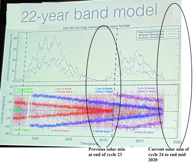
-
Cold core surprise is possible in the Mid South still. Lows are stacked, which is helpful for that type of deal. However cold core is not my wheelhouse. Wake me up in April. Hopefully after Kansas wins the NCAA Tourney in ATL.
-
Yes those charts are not bad for winter. I was whining about spring severe. That'd work next winter for me.
-
Hope that's wrong. Totally backwards vs severe favorable TNI.
-
Hopefully we can avoid Death Nina SER. Japan model isn’t too bad. Most of the cool is south of the Equator. Is the PDO trying to take a breather? Better be after spring cause warm off West Coast makes severe season bo-ring! Now, that look could be nice next winter if the central north-PAC keeps cooling.
-
Well that would suck the life out of severe. I place my order for cooler weather central tropical Pac. Keep warm east. TNI boom!


