nrgjeff
-
Posts
4,248 -
Joined
-
Last visited
Content Type
Profiles
Blogs
Forums
American Weather
Media Demo
Store
Gallery
Everything posted by nrgjeff
-
European weekly charts are beautiful. Looks like we need to get through next week. I favor warmer ensemble clusters that slow down the front. Either way I'm in agreement with good times after Labor Day. End of ensembles shows AK ridging. Weeklies both show Midwest to Ohio Valley trough. We take!
- 168 replies
-
- 4
-

-
- leaves changing
- temperatures
- (and 2 more)
-
Iceman: Tired of summer. Switching to fall. I do like the last few posts on the summer thread. EPS is indeed pushing a cool front through the Midwest to the Mid South. Can we get it all the way through? Probably so in some form. Looks a little hot and humid until we can get these tropical cyclones pushed out. Laura going west is going to behave like a warm front, especially in August. Midwest system next week may not quite be enough to scour out the airmass. However the 11-15 day period looks a little more encouraging. European weeklies are quite friendly to a moderating temperatures forecast. Looks at or below normal through about week 3. Gets us past mid-September before any aboves. By then slight above is fine, esp if not too humid. Except for late August heat, I will try to remember to post mainly in the Fall thread. Cue up some Ce Ce Peniston. Finally!
- 168 replies
-
- 3
-
-
- leaves changing
- temperatures
- (and 2 more)
-

Wild Speculation for Winter 20 -21
nrgjeff replied to Holston_River_Rambler's topic in Tennessee Valley
European monthlies are on fire through the end. Literally it's every single month. Obviously that's wrong. I'd expect a cold month, or perhaps split in a couple two week periods, this winter. Otherwise, yeah I'm thinking pretty warm based on persistence and La Nina introducing a January thaw that goes straight through February. -
European weeklies came out and are not quite as hot as the Monday issue. They basically sharpened up the North ridge. Too bad for them! Leaves us down South near normal vs the slight above. So far I guess that's encouraging... Unless the road through fall has that North ridge settling into a SER in Sept/Oct. It does not necessarily have to go that way. The North ridge could just crumble as summer ends. Fingers crossed. Keep that crap out of here, haha!
- 168 replies
-
- 4
-
-
- leaves changing
- temperatures
- (and 2 more)
-
European weeklies just went hot again. Core heat is still North. Color me skeptical of four hot weeks here. Let's try two again, like July, otherwise North. I'd like to think if we pay our dues in July and August we get football weather on time. However I think we all know the odds. Probably stay pretty warm Sept.
- 168 replies
-
- 4
-
-
- leaves changing
- temperatures
- (and 2 more)
-
Nice picture! Is she your daughter? Precious! It's funny I never know where in life forum members are. I've a daughter who loves the outdoors. She's a bit older, is every bit the explorer too!
-
Wild Speculation for Winter 20 -21
nrgjeff replied to Holston_River_Rambler's topic in Tennessee Valley
I like it! All hail the guts to put out detailed thoughts months ahead. Agree December is probably the best shot at sustained BN temps, along with bookend weeks of Novie and January. ABNA index is another consideration. Keep a warm North and our source is wrecked. True Alaska / Yukon may be colder, but it'd have to traverse a warm southern Canada. If the Northern US lacks snowcover, modification kills the cold airmass. La Nina influences may show more later in winter late January and February. Yeah a SER would be a drag. I'm OK if it's sunny - better than cloudy and mild. Perhaps by November or early December we'll know a secondary pattern - and hope it is one that interrupts the SER. European monthlies are on fire January. Good grief! Glad it's the last month and pretty much zero correlation with actual wx. -
The lamenting in the Plains chasing community is off the chart. Final stats are somewhat closure, and somewhat more reason to whine, lol! Hurricane season is ramping up and tropical fans are excited. How do I feel? Picture Clint Eastwood on his porch in Gran Torino.
-
Looks reasonable. After the current KW passes through the Western Hemisphere, the Pacific looks open for more tropical easterlies. Then La Nina might tip its hand. We are past the spring predictability barrier. Subsurface obs and model forecasts all line up well for La Nina in winter.
-
They do mention the Tennessee Valley twice, or on two days. We'll see. Ohio Valley could get it too. Everything is pretty unidirectional upstairs, but there is flow for wind or hail. I was looking back at the May 31, 1985 outbreak in Ohio, Penn, and NY State. They had just a little turning from WNW 500 mb to WSW 850 mb. Intriguing. That's not in the cards this week. However I will keep it in mind balance of June north of here.
-
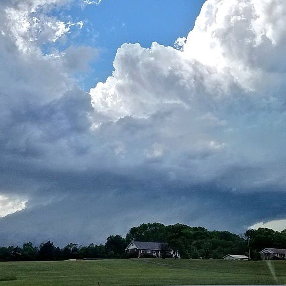
Looks like a beautiful shelf cloud with scud underneath. I see that often in East Tenn. Regrettably/Fortunately (depending on one's perspective) it's not dangerous and not a tornado. Looking ahead, desperation has me watching for a tropical cyclone landfall next weekend or later. If it's central Gulf I might be interested in the outer bands supported by robust LLJ like winds off the surface. Zero interest in a landfall intercept, but maybe right/east side tornadoes. The 2020 debacle continues. No Plains chase. Almost hit overnight at home. Upper Midwest death ridge. Tropical temptation desperation.
-
Today has an enticing surface set-up. Looks at upper air charts and forecasts. Unidirectional. Pukes up breakfast!
-
Oh I forgot about early terminating El Nino. Hope springs eternal Upper Midwest, this year! Oh my that Texas hail would have been terrifying, coming through the roof and ceiling.
-
Good year for VZ to give 15G data April and May. Too bad I didn't use mine chasing. Come on Verizon, June too!
-
Yeah I think we'll Nina this winter. KW will delay things a bit for summer. However the eastern Pac is in full easterly mode. Ventrice put something on Twitter including the Pac and Atlantic. I didn't comment, but it screams hot humid SER this summer. My previous negativity aside, La Nina would tee up more Dixie Alley severe next spring. Saving it for the Plains seems silly. Guess we chase the Jungle in April! Finally, Jax, this is all petty stuff compared to cancer. Praying your wife beats that, and praying for your whole family's strength through the battle.
-
Definitely a tornado above. NWS concurred on Twitter and by email. Note the average size wall cloud structure. It's not some broad shelf cloud and scud. It's the real deal!
-
Super Nina winter blowtorch. Fades by spring. No severe. Guess who's despondent? Finally threw in the flag no chase trip. Since the Plains May has been DOA 5/7 years in a row, it's time to take Dixie seriously and just chase around here in April.
-
Old Hickory is itching for some action. Cooking boundary in May often produces. However the LLJ is DOA east of I-65. It's weak west of there. Probably would just maintain any MCS with straight line winds up to I-65. It's really not strong enough for tornadoes; but, you never know around a boundary in May. Pulse type thunderstorms are progged over here near KCHA. We've got zero LLJ out the window or on the models. These Cu are just sitting like in the middle of summer, no movement.
-
Brutal Mutual aid restoration crews have been so busy this year. We still have work going on in the EF-3 damage area of Chattanooga, basically rebuilding from scratch. However most everyone else was restored within 10 days after Easter. I'm still amazed at how quickly they rebuilt the main lines. Why can't road construction be that fast?
-
Looks like the real deal to me. Funny everything goes earlier than season this year. Nashville tornado along an east-west boundary in March seemed more like a May set-up. Now here we are with a quasi-derecho situation almost a month earlier than normal. I'm not saying it'll be a true derecho, but it's an MCS riding / sliding ESE on the nose of high CAPE (for early May) with moist southwest winds feeding the beast. Storms sinking south of, drifting away from, the upper-level wave may be what prevents the strongest scenario. Should be several damaging wind reports in Tenn. Hopefully nice shelfie pix are incoming.
-
That stubborn 3 region is killing my Plains plans. Agree the KW may cut SSTs but it's a tough area for MJO convection. Perhaps late May the new pulse in the IO will have more influence. Then for next winter hopefully not the dreaded warm version of Nina. I'm OK with sunny SER but the lack of snow is boring. Conundrum for sure!
-
Though low level winds are veered off, today could be interesting in the Shelfie category along I-40 especially Plateau and points west. Winds surface to 850 all look similar west of south. However there's decent speed for May especially higher up. Good recipe for straight line winds with the CAPE building. Some CAMs have cells hooking into southeast Tenn. Others have things stabilizing from the main I-40 show and outflow. Finally there's the question about the main show/line east of the Plateau. Can it get to Knoxvegas? Cell and outflow interaction may determine how fast things stabilize this evening. At least we have something to track. We could use a break from tornadoes, so straight line wind is acceptable.
-
Yeah it just clouded up over both areas of surface convergence. Thundershowers are in progress, but it's not not energetic enough. The clouds just blossom on the loop. That'd be great in winter, but lol in spring. Also see Windspeed right above. Remember to read SPC discussions, even on the junk days, since it helps discern the good the bad and the ugly. Local office discussions often add more detail. Find it on weather.gov/mrx and the drop-down menu from forecasts to Forecaster's Discussion. Weather pattern turns incredibly boring after this. See y'all in a couple weeks, lol!
-
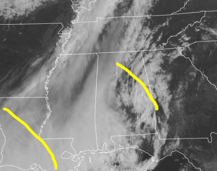
Dewpoints are way behind schedule compared to all 3 CAMs NAM/WRF/HRRR. North Bama dews are in the 50s; it's progged low 60s Td by this time 14Z. I was hoping for a repeat of Saturday structure; but, looks like no dice. Though the LLJ is screaming (and mixing down) it may be shunted east this afternoon. Thunderstorms will still develop. Two shortwaves are noted coming through the flow. The first is already into Georgia marked by mid-level cloud signature. Then we have new lift coming from Louisiana, marked by the ribs in the high cloud deck. Mid-levels will also cool with time this afternoon. Thunderstorms yes. Fireworks, probably not.
-
Always Cookville. Photos on Twitter look grungy though. Jives with lots of rain wrap around on radar up there. Documented this foot / beaver tail around Ooltewah, before following toward Etowah. No touchdown, I saw the base at times driving. This is where I could safely pull over. It was a low-top mini-sup with tilted updraft. No true wall cloud, but it's gorgeous.