nrgjeff
-
Posts
4,200 -
Joined
-
Last visited
Content Type
Profiles
Blogs
Forums
American Weather
Media Demo
Store
Gallery
Everything posted by nrgjeff
-
Memphis had some drama Wednesday eve. They tornado warned Arkansas just west of town. Good thing it did not pan out. Heading right to the most populated area. Saw a nice shelfie on Twitter or somewhere. Clarksville also had a suspect cell. Never warned and didn't go severe. Friend sought out the base from Austin Pea U. Not bad. So, PowellVolz we have another severe enthusiast? Jax is another one of us. Everybody join us. You do not know the power of the Dark Side!
-
Tuesday was interesting. Wednesday (today) looks like another possible Marginal to Slight upgrade. Similarities include a surface boundary in the region include CAPE (absolutely ludicrous humidity) and a CV / vort max coming out of Arkansas. Difference is surface is all veered off today. GFS/NAM keep it so. Euro 06Z develops a meso-low on the Ky/Tenn border that'd light up! PS the HRRR is doing HRRR things. Maybe 16/17Z closer to game time it will be useful.
-
And now the CFS came around to the Euro weeklies with 2-3 BN temps weeks. I do like a warm October for fall foliage. Hard to get in the mood if it's too cold. Cool nights are great of course. Warm afternoons just make the day! Then for winter, hopefully we get some snow and Southeast skiing.
- 168 replies
-
- 4
-

-
- leaves changing
- temperatures
- (and 2 more)
-
I have a good feeling we will have a fall this year. European weekly charts (like ensembles) are a little slower on the cooler air settling in later next week. However they keep early season football weather around longer than previous runs, and longer than the CFS does. Keep in mind October is typically warmer than normal in La Nina years but November is then cooler than normal. Correlations are weak. Just noting in case October is warm, it does not necessarily last. Second half of winter is a different story, but let's enjoy fall first.
- 168 replies
-
- 3
-
-
- leaves changing
- temperatures
- (and 2 more)
-
Models have reeled it into the 6-10 day period. Looks like a Real Cold Front (RCF) tm middle of next week. Get a little break over the weekend. Humidity may rebound ahead of the RCF early next week. Severe weather would be fine by me. Then football weather!
- 168 replies
-
- 5
-
-
- leaves changing
- temperatures
- (and 2 more)
-
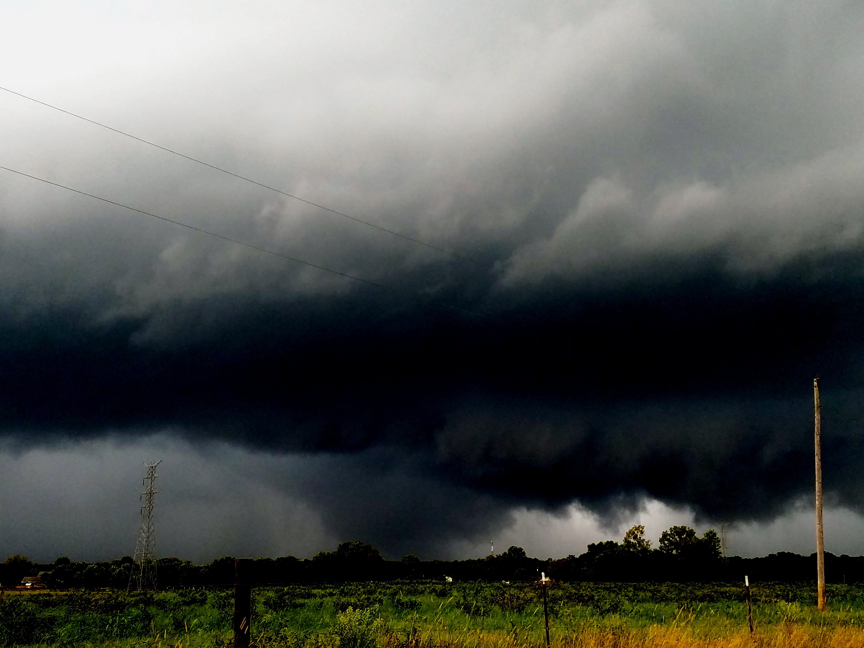
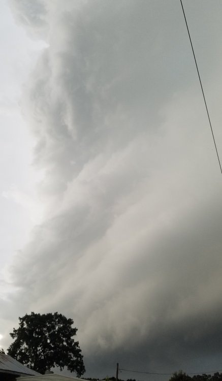
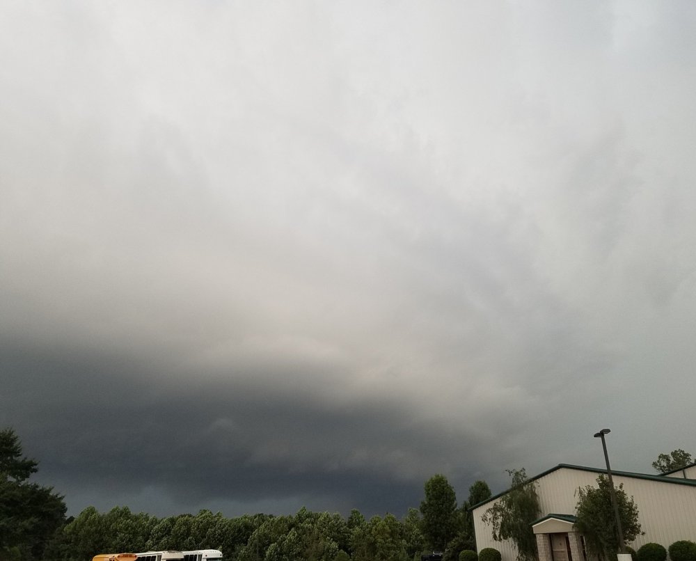
The UAH SWIRLL sounding above hinted at action. Oh yeah, the Cullman AL area got action. Cullman, anyone surprised? I visited for my first time Friday. Cullman sits on a low plateau; but yes, it's elevated which helps inflow winds. HSV NWS surveyed a couple weak tornadoes near West Point and Eva, which is a track just northwest of Cullman. I followed that storm but did not see the tornadoes. Happy to report excellent other structure and a good chase. Heavily doctored photo looking west from Falkville, AL. I still do not discern a tornado, but it's a heck of a Dixie supercell. Believe the dark spot is looking sideways through a C-shaped heavy rain band. If it's a funnel one cannot confirm it's down. Pancakes just northeast of Cullman at Cornerstone (church) Revival Center. Pastor is really nice. We chatted about the storm of course. The storm was so good he forgot to ask me about Jesus! I told him the church is OK and any rotation will pass to the northwest. Little did I know a tornado was indeed in progress near Eva. Barber pole between Cullman and Arab, AL as I took AL Hwy 69 toward home. Reminds me of an old friend US-69 in Kansas.

-
Yes another tornado reported near Oxford, Miss this morning. Had an MD before 7am Central, even though low watch probs. Still we're getting started early and often. 13Z SPC talking possible ENH upgrade for tornadoes. Paraphrase: Inland decay phase can be the more prolific tornado day. Wind fields spread out into better CAPE environment. Set up does remind me of the Harvey tornado I documented in northwest Alabama. Well it almost documented me, ha.Y'all it's Free for all Friday!
-
European weekly charts are beautiful. Looks like we need to get through next week. I favor warmer ensemble clusters that slow down the front. Either way I'm in agreement with good times after Labor Day. End of ensembles shows AK ridging. Weeklies both show Midwest to Ohio Valley trough. We take!
- 168 replies
-
- 4
-
-
- leaves changing
- temperatures
- (and 2 more)
-
Right front will be the main show overnight. Arkansas has truly rain-wrapped tornado warnings in a shield of rain. Also think leading edge of the rain is going into higher CAPE in western Mississippi. Friday right front quad may remain so, but it's way up over Kentucky. When Laura gets more hybrid, could be sups straight east or even southeast with those convergence lines in more CAPE.
-
Friday slight risk is justified. Laura will start to assume hybrid characteristics regardless of the depression designation. Appears the 500 mb winds will be veered compared to 850 mb, more turning than a pure tropical system. A 200 mb jet streak will be over North Georgia and southeast Tenn. However the best overall features appear northern Middle Tenn. Two convergence lines are shown on all guidance, CAMs and globals. One pushes out toward the I-65 by midday with another coming out of West Tenn mid afternoon. I think the back one will have more CAPE with which to work. Front one may run into an even farther east feature, morning rain East Tenn. Focusing on the back convergence line, it appears to intersect even more backed winds around Clarksville mid-afternoon. Calling that the hybrid quasi triple point, east-southeast of the surface low. Should be great convergence and excellent turning there. However CAPE will be greater, with still good turning, Nashville south. While this reads like a severe wx post, well it is, I will post in the Laura thread.
-
Don't worry about that Euro chart. Use regular old surface wind progs. Believe it or not they are pretty good inland. I figure that Euro peak wind product is for individual strong/severe storm cells, based on CAPE and column water content. It's definitely not the circulation. Thanks @Carvers Gap for the keenly props, but I probably got lucky. I'm definitely thankful July was peak summer vs August. Hello @mempho I certainly have inland Laura impacts in mind. I'm a sucker for Dixie Alley when tropical depressions bring low level shear well inland. More on that in the severe thread if I get time to write anything coherent. East moving remnant low will promote storm cell motion slightly right of the mean low level flow Friday. hmmm
-
Iceman: Tired of summer. Switching to fall. I do like the last few posts on the summer thread. EPS is indeed pushing a cool front through the Midwest to the Mid South. Can we get it all the way through? Probably so in some form. Looks a little hot and humid until we can get these tropical cyclones pushed out. Laura going west is going to behave like a warm front, especially in August. Midwest system next week may not quite be enough to scour out the airmass. However the 11-15 day period looks a little more encouraging. European weeklies are quite friendly to a moderating temperatures forecast. Looks at or below normal through about week 3. Gets us past mid-September before any aboves. By then slight above is fine, esp if not too humid. Except for late August heat, I will try to remember to post mainly in the Fall thread. Cue up some Ce Ce Peniston. Finally!
- 168 replies
-
- 3
-
-
- leaves changing
- temperatures
- (and 2 more)
-
Three years ago today we were eclipsing! No social distance. Gathered in big happy groups. Got blown away by Nature. Happy reflections! At least this year we had Comet Neowise, a minor but nice concession. Have a good weekend!
-
European weeklies want to end summer right on time. Looks like seasonably hot the end of August, in line with both Ensembles. Then the ECMWF weeklies follow the CFS at or below normal temps the first half of Sept. Such an evolution is reasonable with current MJO and ABNA expectations. Also active tropics and precip. To celebrate I should probably post this in the fall thread, but I also talk about tropics. Maybe next time!
-
Yes the end of the 11-15 day (both ensembles) and the 16-20 day (ECMWF weeklies) hint at some heat end of August beginning of September. See if it can reel into the 6-10 day, but I'm OK if it doesn't, haha! CFS does not echo the heat. After Labor Day September looks fairly benign on the heat front. It's supposed to be so, but we know how the last few years went. Tropical cyclones may impact temps either way too. Speaking of that, I cannot promise benign in the tropics. Starting in late August this MJO pulse might light up the Atlantic into early Sept. Gulf storms tend to behave like warm fronts for the South (outside of rain). East Coast storms can bring some heat relief back side, esp in Sept.
-
Apparently the FF guidance is low there. WPC has flood risk. On the bright side somewhat fall-ish weather is on deck after the front. Watching the Perseid(s) the other night (only one, lol) I noticed Orion coming up in the East. Orion is of course a staple of the winter evening sky. He's like, hold on, fall and winter are on the way! Hopefully more snow will grace the Mountains this winter, though it'll be a chore with La Nina. Ski areas need our support more than ever. I'd say if not bar hopping at night, it's safe to ski/ride bundled up with face coverings anyway. Get take-out to support restaurants. Never too early to think ahead, lol!
-
Looks like relatively nicer weather much of next week. Take the temps down a bit and dews will get into the 60s a couple days, nice compared to 90s/70s. However dews may be back late next week with precip. Following week temps and dews look seasonable. No complaints I suppose as we count down to Sept. Euro weeklies aren't bad. They reflect the slightly lower temps next week; and, try to stretch it into the following week. Ensembles are normal in the 11-15 day, so I think seasonable unless a ton of precip. Outer weeks 3-4 show slightly warmer than normal, but normal temps will be falling. Verbatim that's not new heat.
-
European weeklies continue to keep the heat ridge focus elsewhere, though it'll be seasonably hot here. First the Asia Bering sea North America ABNA index has shifted from positive to negative, with little net effect for the Valley. Asian side the ridge dropped from eastern Siberia / Mongolia / North China into South China. Over here the Great Lakes southeast Canada heat is forecast to shift more Plains, Texas and Southwest. Latter is already hot. Appears we in the Valley may luck out if the Great Lakes ridge does not drop into a SER. China may have a SER, lol. Southwest US and Texas appear to be the destination here. European weeklies take the hand-off from the ECMWF ensembles with the Southwest US ridge and some extension into the Upper Midwest. Gives opportunity for weak fronts and more moderate humidity, but not really as cool as the 12Z ensemble depicted. Even when the Northeast US gets it at times, seems to go up and over us. That'll leave it humid though. ABNA and European weeklies have somewhat similar themes. Cautiously optimistic after early this week intense heat (Mid South more than East Valley) will give way to more normal-ish August heat. With any luck no more big heat waves. However continue summer theme of steady hot.
-

Wild Speculation for Winter 20 -21
nrgjeff replied to Holston_River_Rambler's topic in Tennessee Valley
European monthlies are on fire through the end. Literally it's every single month. Obviously that's wrong. I'd expect a cold month, or perhaps split in a couple two week periods, this winter. Otherwise, yeah I'm thinking pretty warm based on persistence and La Nina introducing a January thaw that goes straight through February. -
European weeklies came out and are not quite as hot as the Monday issue. They basically sharpened up the North ridge. Too bad for them! Leaves us down South near normal vs the slight above. So far I guess that's encouraging... Unless the road through fall has that North ridge settling into a SER in Sept/Oct. It does not necessarily have to go that way. The North ridge could just crumble as summer ends. Fingers crossed. Keep that crap out of here, haha!
- 168 replies
-
- 4
-
-
- leaves changing
- temperatures
- (and 2 more)
-
Wow 3/4 days the East Brainerd bubble is broken. Hey @dwagner88 no watering this week, lol!
- 186 replies
-
- 2
-
-
- tennessee river valley
- wind
- (and 4 more)
-
European weeklies just went hot again. Core heat is still North. Color me skeptical of four hot weeks here. Let's try two again, like July, otherwise North. I'd like to think if we pay our dues in July and August we get football weather on time. However I think we all know the odds. Probably stay pretty warm Sept.
- 168 replies
-
- 4
-
-
- leaves changing
- temperatures
- (and 2 more)
-
Oh wow that's beautiful! We hiked a short stretch of the Cumberland Trail with rock houses and water in which to wade. Oh but I miss the Rockies! Would love to go out there when the Aspens are glowing - never been that time. Maybe pull a fall Plains trip with Aspens on the down days. I don't know.
-
Regrettably it looks like more of a heavy rain and flooding event. Disgusting boundary been parked here since Comet Neowise got good. Ugh! Boundary disappointment 1.0 was the Comet. Boundary disappointment 2.0 will be wasting decent flow aloft for early August severe. Rant! On a brighter note, the heat will ease up. CFS is probably too cold, but the ECMWF ensembles and weeklies agree with less intense heat here. +ABNA signal continues to look hot for Canada and the Great Lakes. US Southeast soft spot does line up with the Korea trough @jaxjagman noted earlier. Then up North both Eastern Siberia and Eastern Canada have AN temps. +ABNA has been consistent most of summer so I think it adds credibility to the forecast. The two weeks of heat here was hopefully just a tempo ridge expansion. Now we go back to the more traditional +ABNA. Hotter model runs run the risk of device advection. Thursday evening edit: Euro weeklies once again favor the downshift heat for the South. Canada is warm. US West is hot. Looks like a classic climate change signal. So the year we finally have football weather, will we have football?
-
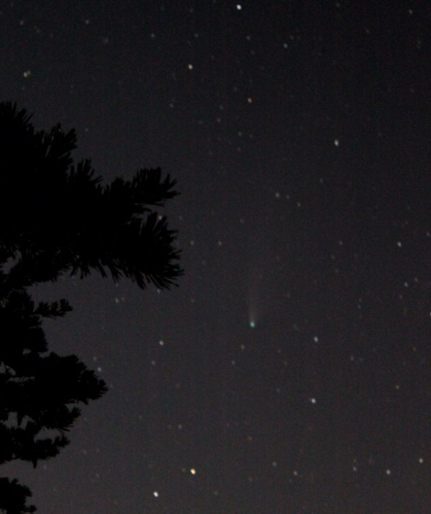
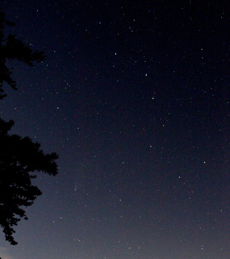
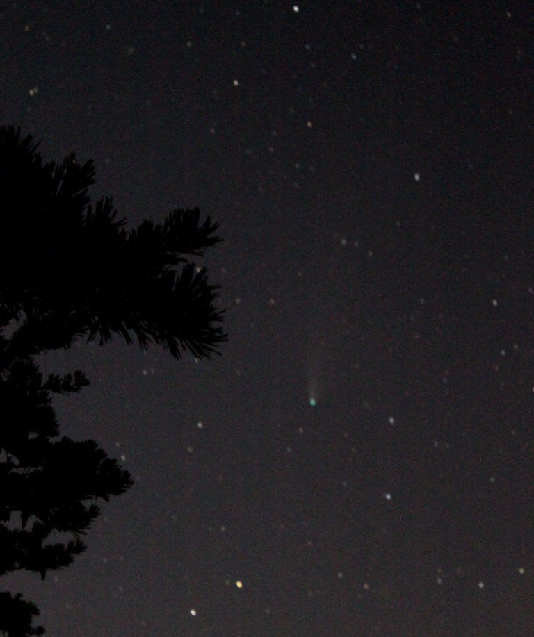
Sunday night weather cooperated so went up Lookout Mountain again. Comet has faded a bit, despite great visibility clear air, perhaps competing with moonlight. Tail appears shorter through binoculars, and it's a struggle unaided eye. Still fun to see our inner solar system visitor. Delicate beauty remains inspiring. Monday we'd intended to see the comet again as afternoon thunderstorm debris cleared by evening. Ooops! New mid-level clouds developed ahead of the trough in the western sky. However the Moon, Jupiter and Saturn were ripe for viewing in the excellent visibility air south and east. Didn't even see the usual wobbles in the 'scope (summer instability) so it was grand. Atmo probably was stabilized and overturned by previous t-showers. Just my daughter and I out back (usually front) so no sharing with the neighbors kids, haha. My plan: comet. God's Plan: planets. Often the spontaneous is the most blessed time. We take! Likely my last comet pictures are below. They are Sunday from Lookout Mountain. I've yet to venture into telescope photography. I will probably still check on Comet Neowise clear nights through the week; but, we said our goodbye Monday right before the cloud. This has been a fun 10-14 days (3 weeks if morning). Next, meteor shower tonight if clear. Comet gets high enough for the Big Dipper combo pic. Tree branch points the way. Try a 'scope?