

Kmlwx
-
Posts
13,549 -
Joined
-
Last visited
Content Type
Profiles
Blogs
Forums
American Weather
Media Demo
Store
Gallery
Everything posted by Kmlwx
-
75kts of shear might rip apart updrafts as well though.
-
That being said - I would be happy even with a nice few claps of elevated thunder. The only way I'm okay with mosquito season is thunderstorms - Not looking forward to sweating my butt off for months on end.
-
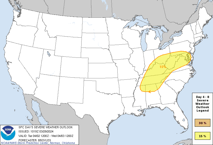
I'm with @George BM for the most part. We've played this movie before...warm fronts this time of year struggle to get as far north as forecast unless there's some super anomalous push. Heck...even later into April they can struggle...and this would be ultra-early April. Will be interesting to see how this unfolds - but yeah that's a beefy/large 15% area. My guess is that NoVA might get into some surface based action - but I'm not sure I buy north of the Potomac and especially not closer to the M/D line. It's nice to have something semi interesting to track, at least. Maybe a sign we won't have a dead early season with weeks of boredom.
-
The last few GFS runs appear to be having trouble pushing better dewpoints and such north of the Potomac. It's pretty darn early still - but it's something to track that's not only in the Plains.
- 1,696 replies
-
- 4
-

-
- severe
- thunderstorms
- (and 5 more)
-
Day 5 15% - woo storms?
- 1,696 replies
-
- 3
-
-
- severe
- thunderstorms
- (and 5 more)
-
The GFS has some decent supercell composite parameters to our west for next Tuesday afternoon - but the timing is bad for us and it fizzles east of the mountains.
- 1,696 replies
-
- 2
-
-
- severe
- thunderstorms
- (and 5 more)
-
From people more knowledgeable than myself - I've heard that it's not as simple as "drop the anchor = stop the boat" - and as a prior poster said - it seems they DID attempt to drop it anyway.
-
The optimist in me would hope that even the most adamant of environmental advocates would see the economic impact of this bridge being out of commission for a long duration. Additionally, perhaps they'd see the added fossil fuel burning from trucks having to find longer alternate routes to get to/from the same spots. But optimism only gets you so far these days lol
-
I would think they will rebuild a bridge. Right now - that's a major way people go if they can't tolerate the tunnel (other interstate option would be all the way around the western side of 695. Obviously the decision probably won't factor in people's tunnel phobias...but I imagine due to the logistics of tunneling, they will keep it as a bridge when rebuilt.
-
A lesser impact - but for folks who do not want to drive through a tunnel - this really sucks for adding travel time to trips through this area.
-
Absolutely this. Horrifying to imagine if this had been during the morning or evening rush hour especially.
-
Well one thing is you can have a hard freeze or two and then have 20 degree plus departures and the averages will look like the freezes never happened.
-
Every few runs of the GFS at least have had a storm system near the fantasy range/end of run that could be a severe producer for our area. Way too far out but has shown up a few times in varying forms.
- 1,696 replies
-
- 1
-
-
- severe
- thunderstorms
- (and 5 more)
-
We usually flag April as "it's still too early" - but it does come with the benefit of having some really potent systems sometimes before we head into the more summery "doldrum" patterns. It seems we always have a bit of a "butter zone" in spring and fall when CAPE is healthy enough for more than just pencil thin lines of gusty showers - but with higher shear than you'd see in July.
- 1,696 replies
-
- 1
-
-
- severe
- thunderstorms
- (and 5 more)
-
I'm torn on whether to root for a last minute freak snowstorm that makes me lose....or if I should just hope for the win at this point.
-
I had not been checking the thread - I thought for sure I would be out after the little snow event. Goes to show you weather is a lot of guesswork...my entry was a total shot in the dark.
-
The wind was really rocking last night for a time but it seemed mostly synoptic wind in nature rather than specifically associated with that line of showers. Hopefully before too long we start tracking spring severe!
- 1,696 replies
-
- 2
-
-
- severe
- thunderstorms
- (and 5 more)
-
That HRRR map shows the localized DC bow very well. #derecho
-
Line segment between Rosedale and Clay in WV looks nice!
-
SPC playing catchup. It's June 29, 2012!!!
- 1,696 replies
-
- 3
-

-
-
- severe
- thunderstorms
- (and 5 more)
-
Tracking *something* (even a pencil thin squall) would be fun and a welcome break from the winter crap-tracking. Obviously it's early for anything super beefy - but stranger things have happened. I personally think one reason severe tracking is a bit more "civil" and "tame" than the winter stuff is other than my stupid CIPS posting, we really don't look much beyond 8 days (from the D4-8 outlook) for severe. Save for a major signal, like 95% of our severe threat windows pop up within 7 days - and often more like inside 5 days. We aren't pattern hunting for weeks looking for a hint of severe. Add in that you can get a rogue pulse storm that wipes out 1000 trees and sneaky stuff is all around. Not looking forward to bugs and heat...but I sure as heck am ready to end the boredom of tracking nothing.
- 1,696 replies
-
- 4
-
-
- severe
- thunderstorms
- (and 5 more)
-
Is there ducting going on?
-
Not to mention their ideas can generally be found elsewhere on the interwebs as well! I just hope we don't drop into a months long doldrum of boring weather. I can deal with little stretches of beautiful weather...but prolonged stretches get BORING. Hopefully we get some nasty freezes late season to cut down on the mosquito populations
- 1,696 replies
-
- 1
-
-
- severe
- thunderstorms
- (and 5 more)
-
It just never fails
- 1,696 replies
-
- 1
-
-
- severe
- thunderstorms
- (and 5 more)
-
Ultimately it's going to be very specific if we are talking about personalized backyard results. But area wide it doesn't get much more intense than June 29, 2012
- 1,696 replies
-
- 2
-
-
- severe
- thunderstorms
- (and 5 more)

