

Kmlwx
-
Posts
13,549 -
Joined
-
Last visited
Content Type
Profiles
Blogs
Forums
American Weather
Media Demo
Store
Gallery
Everything posted by Kmlwx
-
Done
-
It's early, but might as well do the annual severe thread (people were talking about it in the long range thread!). I don't have the @WxWatcher007 scale handy on this computer - but I usually post it for posterity for the upcoming severe season. Anything from discussing past events to potential upcoming patterns/analogs, and discussion about more specific upcoming threats can be posted in here. A while ago we stopped doing event-specific severe threads for most things. Whether we do that or not - this is the general thread. Have at it!
- 1,696 replies
-
- 3
-

-
- severe
- thunderstorms
- (and 5 more)
-

The Weekend Rule? Saturday 2/17 - The Icon Storm
Kmlwx replied to DDweatherman's topic in Mid Atlantic
It almost makes me wonder if some piece of "bad" data either from an aircraft or a 0z sounding did something odd. Though I think somebody else mentioned it's been a trend for a few runs. -
The Weekend Rule? Saturday 2/17 - The Icon Storm
Kmlwx replied to DDweatherman's topic in Mid Atlantic
35.8/26.2 right now in Colesville. -
The Weekend Rule? Saturday 2/17 - The Icon Storm
Kmlwx replied to DDweatherman's topic in Mid Atlantic
LOVE the Crooked Crab! Tasty pizza there too! -
The Weekend Rule? Saturday 2/17 - The Icon Storm
Kmlwx replied to DDweatherman's topic in Mid Atlantic
New technology was just announced by NCEP to be able to insert a north trend after the event has already happened. Wiping memories of snow and erasing actual accumulation from the space/time continuum -
The Weekend Rule? Saturday 2/17 - The Icon Storm
Kmlwx replied to DDweatherman's topic in Mid Atlantic
Fixed -
The Weekend Rule? Saturday 2/17 - The Icon Storm
Kmlwx replied to DDweatherman's topic in Mid Atlantic
15-25" - final call - area wide with l isolated jackpots to 30" 0" though for Winchester and immediate surroundings. Sorry folks -
2024 Valentines Day Who the Hell Knows - Comeback Thread
Kmlwx replied to DDweatherman's topic in Mid Atlantic
The temp drop here seems to have slowed/stopped right around 33ish degrees. Very pretty out watching this band come down though. -
2024 Valentines Day Who the Hell Knows - Comeback Thread
Kmlwx replied to DDweatherman's topic in Mid Atlantic
Mirroring what others have posted from their stations. Accelerated drop when the precip started back up after the dryslot. Almost down to 33 now.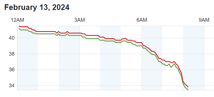
-
2024 Valentines Day Who the Hell Knows - Comeback Thread
Kmlwx replied to DDweatherman's topic in Mid Atlantic
That's brutal dude! lol -
2024 Valentines Day Who the Hell Knows - Comeback Thread
Kmlwx replied to DDweatherman's topic in Mid Atlantic
Down to 34.2 and flakes coming down pretty hard. No accumulation as of yet. -
2024 Valentines Day Who the Hell Knows - Comeback Thread
Kmlwx replied to DDweatherman's topic in Mid Atlantic
I've seen snow at 45-50 even - but the warm layer was exceedingly shallow in those cases. -
2024 Valentines Day Who the Hell Knows - Comeback Thread
Kmlwx replied to DDweatherman's topic in Mid Atlantic
Still 37.9 in Colesville. -
2024 Valentines Day Who the Hell Knows - Comeback Thread
Kmlwx replied to DDweatherman's topic in Mid Atlantic
Actually seemingly stuck now after losing a few degrees with sunset. I guess it's better than having to wait from 60 degrees...my expectations are essentially zero for MBY. -
2024 Valentines Day Who the Hell Knows - Comeback Thread
Kmlwx replied to DDweatherman's topic in Mid Atlantic
43.7 temp and 43.3 dewpoint. Slowly ticking down. -
April 8th Eclipse- Last Easy One To See In My Lifetime
Kmlwx replied to Interstate's topic in Mid Atlantic
Host us -
@Maestrobjwa - If you're going to hone in on dates and calendars to backup your point...you should also take into account that a year isn't truly 365 days. Hence why we have leap years. So really it could be said that each year is never identical to the last - thus throwing off your calendar date patterns.
- 2,509 replies
-
- 1
-
-
- weenie fest or weenie roast?
- weenies got roasted
- (and 2 more)
-
2024 Valentines Day Rain/Snow/Who The Hell Knows Thread
Kmlwx replied to WinterWxLuvr's topic in Mid Atlantic
We really need the DGEX back -
Maybe he meant "folks" in the literal sense? Like "active users" or something? I dunno
-
Thank you! I was adopted when I was 4 months old so I figured at 32 might as well! Sooo much paperwork (South Korea). They said it could be 3-9 months. Maybe by my birthday in September I'll hear something!
-
I just started a birth parent search! The more tasks and embers you can put in the fire to distract from snow the better!
-
- I don't have many "wall of text" moments on here...but when I do I try to make them count
-
Heck...I don't have ANY social life and I'd like to think I'm a lot better mentally about snow than I was 15 years ago. I'm also a lot more cynical (see my snow contest guess(es))
