Kmlwx
-
Posts
13,592 -
Joined
-
Last visited
Content Type
Profiles
Blogs
Forums
American Weather
Media Demo
Store
Gallery
Everything posted by Kmlwx
-
My phones have tended to not get STWs but they do get Flood Warnings and Tornado Warnings.
-
Okay here we go - it's going to try to cycle up. ProbSevere going up steadily now and uptick in lightning. Velocity scans actually look semi decent. Seems like the Howard cell might be losing some punch for the moment.
- 1,696 replies
-
- 1
-

-
- severe
- thunderstorms
- (and 5 more)
-
Rooting for the cell on the Loudoun/Fairfax/MoCo border. The CIMMS probs have been slowly increasing on it - lightning seems to be cycling up and down.
-
The ProbSevere numbers on that Mount Airy storm are up to 19% TOR.
-
I'm a little more intrigued. My temp never cracked 80...but it continues to be extremely moist/soupy out there. It' definitely uncomfortable walking outside. Let's see if the cells forming in NoVA can start to develop any more than just isolated storms.
- 1,696 replies
-
- 1
-
-
- severe
- thunderstorms
- (and 5 more)
-
Little cell popping in Southern Maryland now. Radar looks largely dead. The fat lady is warming up in the wings.
-
Just made a post - not sure what created the boundary - maybe differential heating from the clouds earlier...or maybe a river wind or something. Seems to far W to be a bay breeze. If the Fredericksburg cell can throw off an outflow - and these two meet up it could at least salvage consolation thunder. But yes - this looks terrible.
- 1,696 replies
-
- 1
-
-
- severe
- thunderstorms
- (and 5 more)
-
There is a boundary moving N and W from the DC are that *might* be something to root for to trigger something else. You can see it on the Meso East floater 1 sector visible satellite and also very slightly on the TIAD terminal radar.
-
I think that may be the NAM nest showing the Frederick storm but initiates it too far south. Notice how it barely has anything where that cell is. We just didn't warm up enough it seems. Will hold out for late developing cells/lines - but I haven't even gotten out of the 70s. Up to 77 now (high of the day). Dewpoints are great...just needed some more insolation.
-
Of course that band of thicker clouds rolls in as soon as I say that. We'll see if that more substantial clearing behind can perform. Starting to get well into the afternoon. I'm still stuck in the mid 70s...dewpoint is 71+ though...so at least it's moist.
-
Definitely getting brighter outside the last few minutes.
- 1,696 replies
-
- 1
-
-
- severe
- thunderstorms
- (and 5 more)
-
Clouds, clouds, and more clouds here in Colesville.
-
Mesoscale discussion issued. 80 percent chance of a watch.
-
Does seem like there are some breaks in the clouds in areas like Franklin, WV and near Luray. Not much...but they are there.
-
Lots of clouds to the W though. I'm tempted to MEH for my backyard. Lots of the CAMs really do focus things S and E of 95.
-
Always amazing to see the complexities of severe weather. We all like to point out how "unstable" the models are sometimes in the winter...I'd argue this is a much better example. Overall, the models seem to do a pretty good job with synoptics...smaller scale stuff like storms we definitely haven't nailed down in numerical modeling yet...just too small! I feel like even given the above...this is the most "confused" I've been heading into an event in some time. Usually we at least have some semblance of agreement on a line/storms vs spottier coverage or even a complete miss. I really could still...(even like 18 hours out!) argue for any solution spanning nothing to a fairly area-wide severe weather episode (not talking about another June 2012 of course!)
- 1,696 replies
-
- 2
-
-
- severe
- thunderstorms
- (and 5 more)
-
The Panhandle of WV part of the line looks better now. I still expect some precip IMBY but don't think I'll see severe. Heck...even lightning may be limited if any. Going about as advertised so far.
-
Tons of lightning showing up on that part of the line NNW of Culpeper. Good sign that it's going to town in terms of intensity.
- 1,696 replies
-
- 1
-
-
- severe
- thunderstorms
- (and 5 more)
-
Spoiler: Early showers/storms that keep popping like popcorn to keep us stable. That, or just socked in overcast until a brief clearing that happens too late.
-
Well it has poor timing working against it (not during peak heating). But we've seen many times when lines that are supposed to fizzle completely do make it across the higher terrain. I don't think it'll be an area-wide line though. If it gets to "us" it'll probably fizzle somewhere between the Blue Ridge and the beltway. Game of miles as weather always is!
- 1,696 replies
-
- 1
-

-
- severe
- thunderstorms
- (and 5 more)
-
Completely unscientific reasoning - but if that line can deliver some good storms/gusts (even if sub-severe) to the area...this has the feeling of a mini-heater combining today and tomorrow. We are due...that's my only reasoning really.
- 1,696 replies
-
- 3
-
-
-
- severe
- thunderstorms
- (and 5 more)
-
GFS drops dewpoints into the low to mid 60s in a little pocket over the metro area
-
If the 6z GFS run is right, we really don't see 70+ dewpoints again after tomorrow for the remainder of the run. I wouldn't mind that.
-
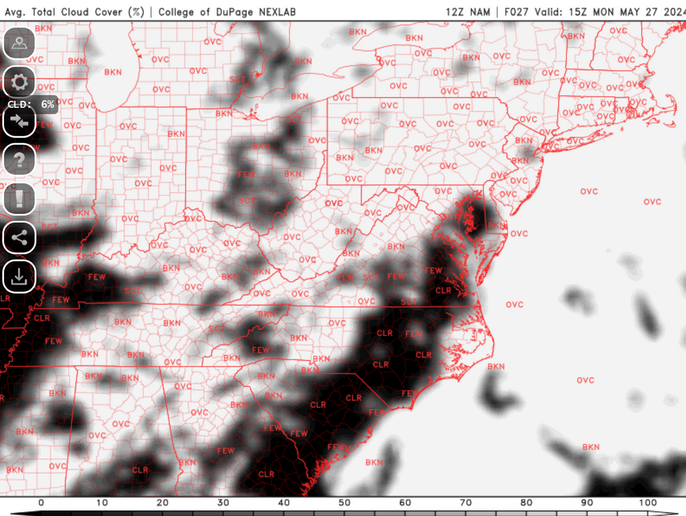
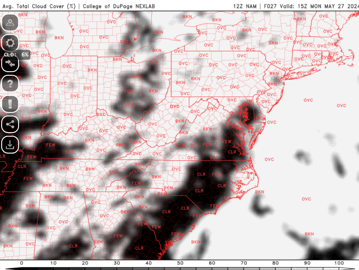
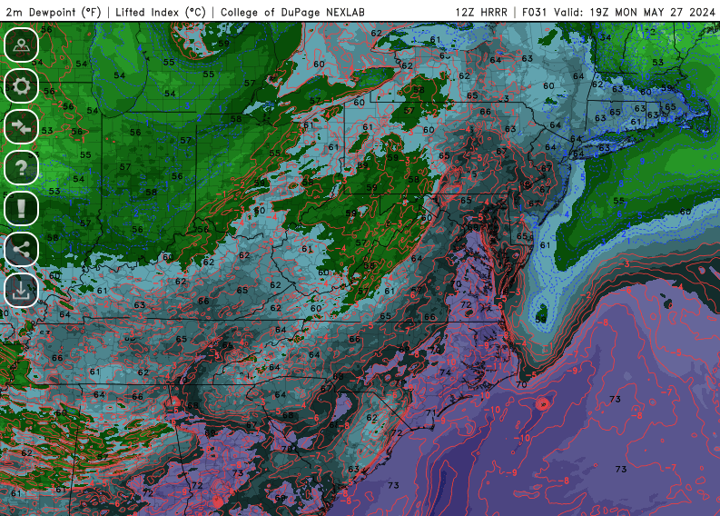
The 3km NAM looks better in regards to MLCAPE - seemingly focuses a corridor running NW to SE roughly along the Potomac (maybe the front @Eskimo Joe was talking about). Problem that I have is that we've seen the NAM nest have dews too high at this lead time before - and that could be inflating the instability parameters. I could make the argument for an absolute bust or a higher end day at this point...sounds typical of our area and severe A good example of the dewpoint argument is the long range 12z HRRR (screenshot below). You can see that the best 70+ dewpoints get limited to SE of the DC to Baltimore corridor. Believe @high risk has said the HRRR sometimes mixes out the dews too much - so that could be a reason to give this solution less attention. One thing that has my interest is the fact that early day activity, while it could dampen severe chances, it could moisten things up to keep dewpoints a bit elevated (like the NAM and NAM nest). Early day activity can also leave behind boundaries (as we've seen before). The issue is that it can also stabilize us too much. It's such a crap chute and gamble for severe around here. Push/pull situation. My gut feeling is that we all (or most of us) hear thunder tomorrow...but that the "focused" severe threat might reside south of a line MD32 and perhaps east of an imaginary line running maybe Rockville down to EZF. That might be a little pessimistic...but I'd rather be cautious at this point. There's enough guidance that really skunks us to give me pause.
- 1,696 replies
-
- 4
-
-
- severe
- thunderstorms
- (and 5 more)
-
Few comments about the 12z 12km NAM so far - it seems to have lots of clouds NW of I-95...subsequently the really high CAPE is SE of the corridor. It also pushes the line through earlier than prior runs.