

Kmlwx
-
Posts
13,592 -
Joined
-
Last visited
Content Type
Profiles
Blogs
Forums
American Weather
Media Demo
Store
Gallery
Everything posted by Kmlwx
-
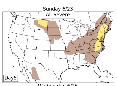
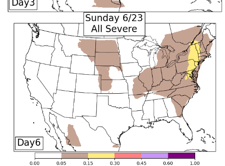
The CSU-MLP stuff is still semi decent for Sunday. I'd want to be as far east as possible as it stands right now for Sunday. We'll see how it keeps moving the next 24-48 hours.
- 1,696 replies
-
- 1
-

-
- severe
- thunderstorms
- (and 5 more)
-
I think it's possible that some of us get skunked on BOTH days of the weekend.
-
Interestingly - some pretty solid gusts on velocity even on that northern part of the warnings - reflectivity is paltry looking - but winds are up there.
- 1,696 replies
-
- 1
-
-
- severe
- thunderstorms
- (and 5 more)
-
Looks like a boundary coming up through NoVA/Southern Maryland from the outgoing complex on the eastern shore. Boundary collisions seem possible.
- 1,696 replies
-
- 1
-
-
- severe
- thunderstorms
- (and 5 more)
-
Looks pretty solid IMO - for rain, maybe not severe. Pretty juicy here with dew over 70 and still 88 degrees.
- 1,696 replies
-
- 3
-
-
- severe
- thunderstorms
- (and 5 more)
-
Kind of a paltry 1630z outlook
-
Yep. Other than the CSU MLP stuff it looks kind of meh. That NAM nest huge bow has been gone for several runs. I just hope it rains on my house to cool it
-
- 1,696 replies
-
- 4
-
-
- severe
- thunderstorms
- (and 5 more)
-
CSU-MLP for wind threat now has a small purple area showing up W of the area for tomorrow.
- 1,696 replies
-
- 1
-
-
- severe
- thunderstorms
- (and 5 more)
-
*fingers crossed* - Found a really well ranked HVAC company to schedule me for today 2-4pm for the AC repair/evaluation. July 11th was the prior company.
-
It looks like the long range 6z GFS sets up a big heat dome to the west which puts us in an area that could be at risk for southward diving MCS-type things. Way too far out though for any clarity. At least something to watch if Wednesday fails.
- 1,696 replies
-
- 2
-
-
- severe
- thunderstorms
- (and 5 more)
-
That's my vote too. Honestly this house's duct work is bad too...central air barely gets to the 2nd floor. Am kind of hoping to start fresh with a new system and better ducting
- 1,696 replies
-
- 1
-

-
- severe
- thunderstorms
- (and 5 more)
-
RRFS A 12z run (at range) is solid for Wednesday PM.
- 1,696 replies
-
- 2
-
-

-
- severe
- thunderstorms
- (and 5 more)
-
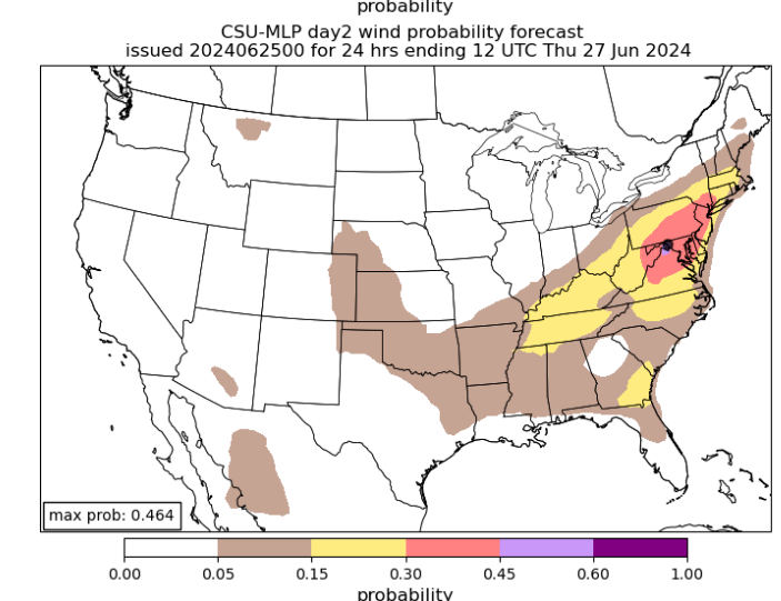
CSU-MLP is honking for Wednesday for damaging wind. LARGE area of red on the map.
- 1,696 replies
-
- 6
-
-
- severe
- thunderstorms
- (and 5 more)
-
12z NAM nest has a heck of a bow echo going through Maryland for Wed evening.
- 1,696 replies
-
- 3
-
-
- severe
- thunderstorms
- (and 5 more)
-
I'm hoping the house can "recover" a bit today. Seems like my Midea 50-pint may be on the fritz as well. It used to drain loads of water to the bucket and now it's barely anything. Those things fail every few years though - and this one is on its 3rd year I think. Lower humidity and 80s will be welcome today. There were two rooms upstairs that were clocking in at 86-88 degrees the past few nights!
- 1,696 replies
-
- 2
-
-
- severe
- thunderstorms
- (and 5 more)
-
Let's hope so...I need some heavy thunderstorms to cool the house. Doesn't even have to be severe... Our preferred HVAC company can't come out until July 11th and the AC has essentially now stopped cooling at all. Have some other recommendations I may go with instead.
- 1,696 replies
-
- 2
-
-
- severe
- thunderstorms
- (and 5 more)
-
My money is on the NAM...if we have mid 50s dewpoints that would be downright comfortable.
- 1,696 replies
-
- 1
-
-
- severe
- thunderstorms
- (and 5 more)
-
94 at the house right now.
-
Good. Because this heat wave isn't even to its worst and I already can't stand days on days of sunny heat waves. I swore off my window AC unit last year because no matter how well it was sealed - wasps were getting in. Regretting that now...bedroom didn't drop below 80 until after 7am this morning. If it's going to be this hot - I need severe to ramp up.
- 1,696 replies
-
- 1
-
-
- severe
- thunderstorms
- (and 5 more)
-
As long as dews and temps drop to tolerable levels...
-
Since CIPS is dead in the water (site has been down for weeks) - we only get CSU MLP. Signal for Sunday has increased again in today's guidance.
- 1,696 replies
-
- 7
-
-
- severe
- thunderstorms
- (and 5 more)
-
That being said...CSU MLP has increased the threat level a bit for Sunday -
- 1,696 replies
-
- 5
-
-
- severe
- thunderstorms
- (and 5 more)
-
For a completely un-scientific reason...I thought maybe things would turn around after that tornado day. Anecdotally we have gone on "heaters" that often start off with a major area-wide event. Weather hasn't been a hugely exciting hobby locally recently. I mean sure - there have been a few things here and there - but certainly no sustained tracking of any sort.
-
Microburst/downburst season I suppose. But yes...localized areas can absolutely get wrecked in July. I think we are still "OK" into late June - especially if we can get some NW flow action. Save for the big no-watch tornado day it's been a real quiet season locally.
