Kmlwx
-
Posts
13,592 -
Joined
-
Last visited
Content Type
Profiles
Blogs
Forums
American Weather
Media Demo
Store
Gallery
Everything posted by Kmlwx
-
A quick/undetailed look at the guidance is a little less impressive this morning. Interestingly...some models like the experimental RRFS A and MPAS ones show almost nothing for many of us Mon afternoon. NAM and NAM nest soundings still look solid - but they have backed off on some of the parameters. SPC day 2 outlook indicates the system has trended weaker and they went with 2/15/15 We'll see how things trend on today's guidance. If it bleeds any further it will just be a garden variety isolated severe day by the time we get to tomorrow afternoon.
- 1,696 replies
-
- 3
-

-
- severe
- thunderstorms
- (and 5 more)
-
30% for hail is pretty unusual around here. It might even be more uncommon than 45% wind. And of course we all know 10% hatched TOR is nearly unheard of except in our juiciest events. We definitely won't see anything like that in the day 2 tomorrow. I'm inclined to hedge lower for now even for the first day 1 outlook on Monday.
-
Totally going off of my awful memory - but I think we do get them a good bit. Particularly the fairly generalized 15% ones. I feel like there was one time I can remember in semi-recent memory that there was a 30% day 3 maybe...I might be wrong. If you're asking @Eskimo Joe - having SPC go big on day 2 or beyond...is a jinx.
- 1,696 replies
-
- 1
-
-
- severe
- thunderstorms
- (and 5 more)
-
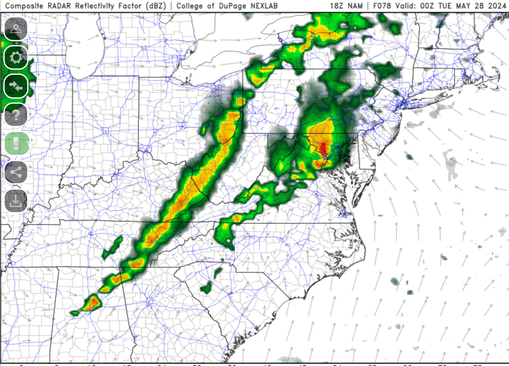
Radar looks good for today!
- 1,696 replies
-
- 3
-
-
- severe
- thunderstorms
- (and 5 more)
-
- 1,696 replies
-
- 3
-

-
-
- severe
- thunderstorms
- (and 5 more)
-
12z GFS continues with lower dewpoints, lower MLLR (significantly lower!) and an overall lesser threat IMO. It's holding steady on those lower dews. I don't think we'll see the 75+ degree dews necessarily. But thinking that will be a key factor here. If dewpoints mix down to the mid 60s - it will probably be a very toned down/limited threat...if we can hold them 69+ I think the threat will be beefier. Definitely on board with Eskimo Joe in terms of these all being very small scale factors that we can't easily resolve this far out. Also remember the usual NAM vs GFS bias of NAM going bonkers with instability sometimes.
- 1,696 replies
-
- 5
-
-
- severe
- thunderstorms
- (and 5 more)
-
I'm still onboard for the most part. Usual caveats still apply 3 days out. Certainly the best threat from 3+ days out I've seen this year IMO.
- 1,696 replies
-
- 4
-
-
- severe
- thunderstorms
- (and 5 more)
-
The NAM and RGEM (and hinted on some of the non GFS globals) pop a bit of a low or at least something resembling one in parts of our area Monday PM. This seems to get that SE wind and enhances dewpoints. The less favorable models seem to keep it more SWerly instead of SErly
- 1,696 replies
-
- 1
-
-
- severe
- thunderstorms
- (and 5 more)
-
The 18z GFS is 3-6 degrees lower on dewpoints than the NAM for Monday...and lower MLLR as well. Subsequently...parameters are much lower, CAPE is much lower and the threat seems a lot more garden variety versus the NAM. The nice thing is...a lot of the other globals seem closer to the NAM.
- 1,696 replies
-
- 1
-
-
- severe
- thunderstorms
- (and 5 more)
-
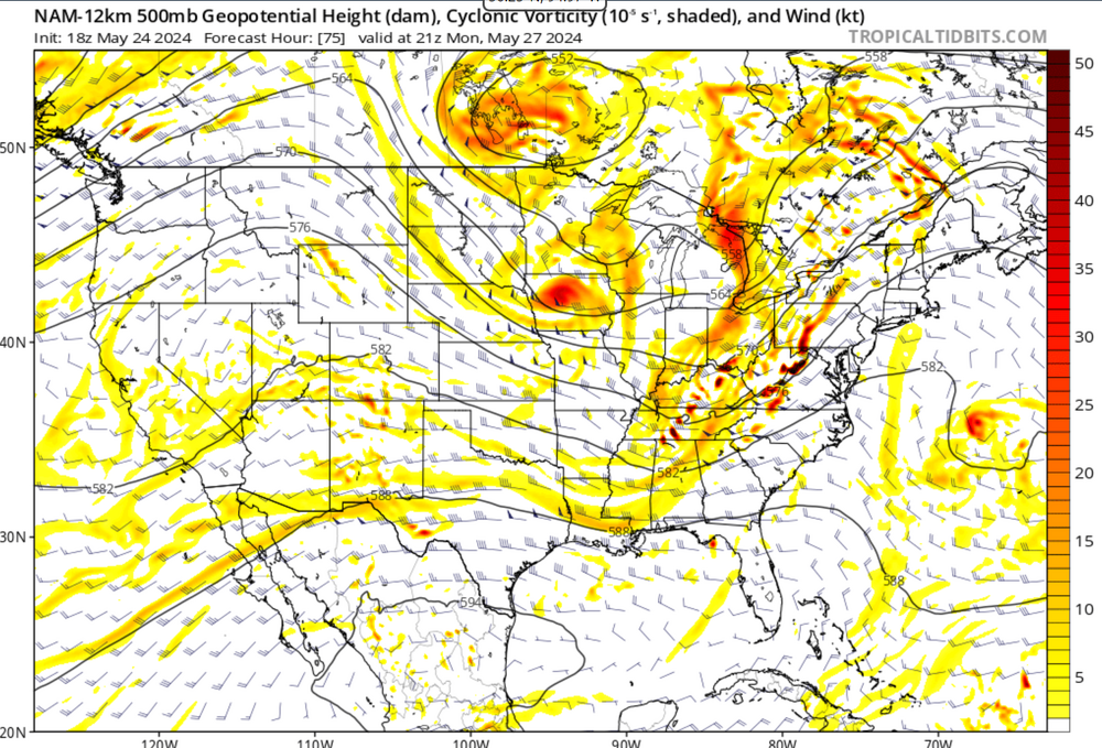
Screenshot spamming - but I will take my chances with this H5 look most times
- 1,696 replies
-
- 2
-
-
- severe
- thunderstorms
- (and 5 more)
-
- 1,696 replies
-
- 2
-
-
- severe
- thunderstorms
- (and 5 more)
-
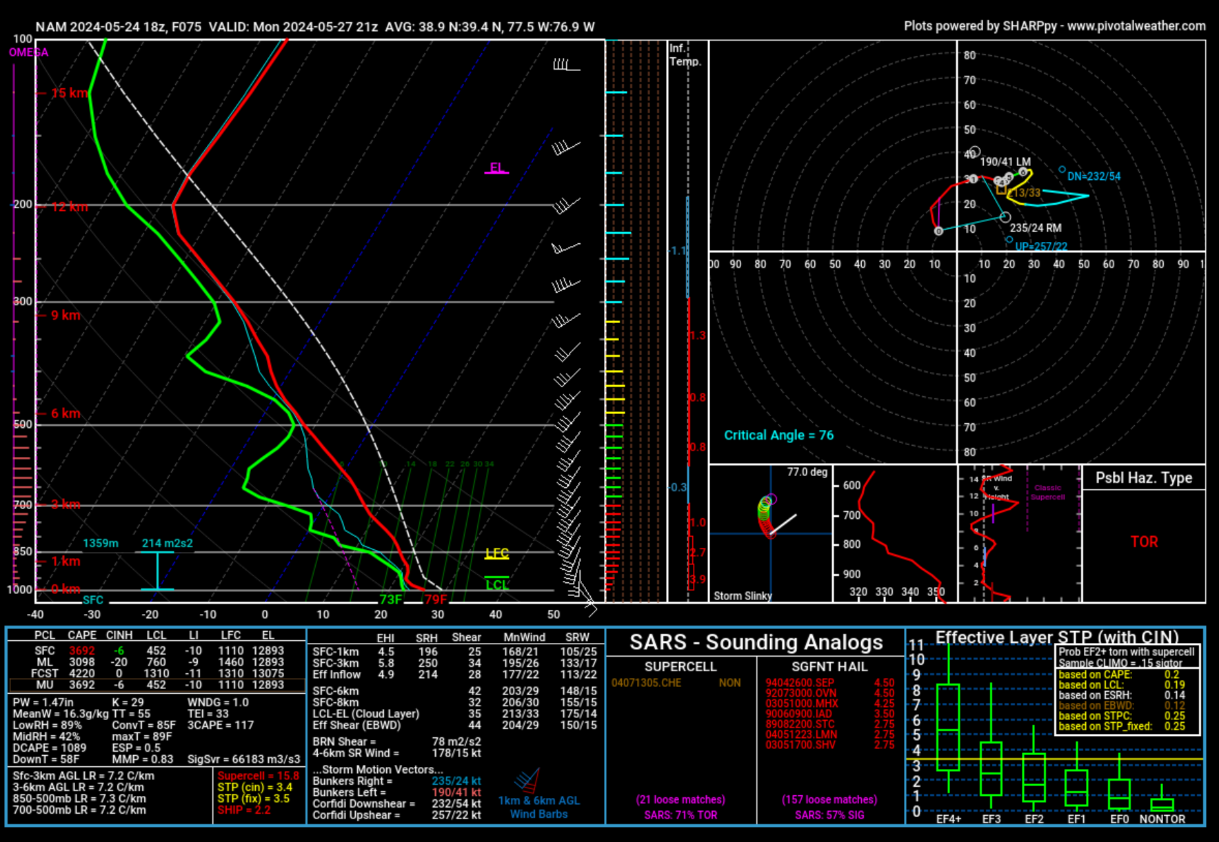
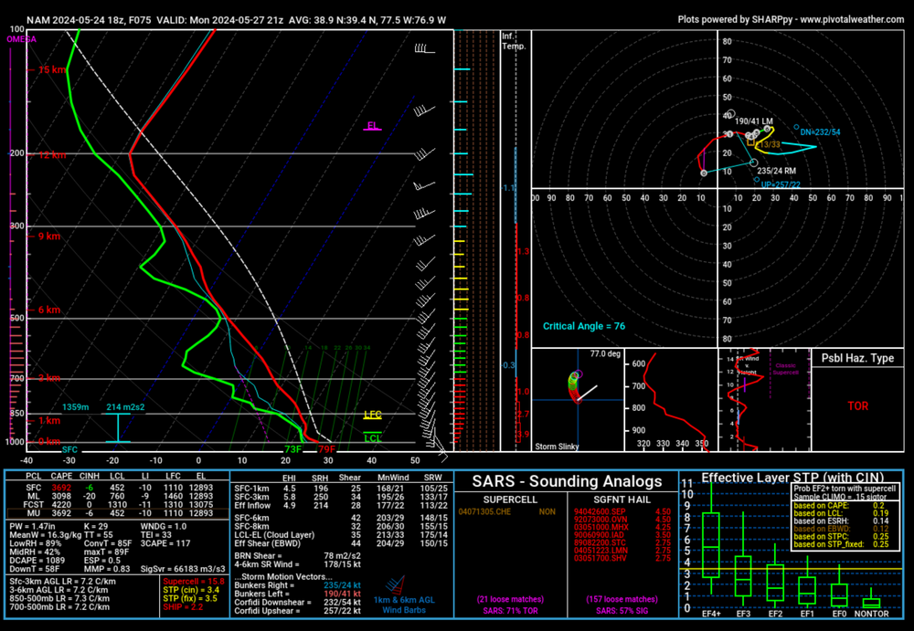
18z NAM (12km) sounding from Pivotal site. I clicked and dragged so it would take an average sounding of MoCo essentially. Again...caveat that it is the NAM at range...but damn....MLLR that aren't horrible, ample CAPE, EHI and SRH up there...and SARS percentages nothing to sneeze at. Look at that SE wind at the surface too...
- 1,696 replies
-
- 1
-
-
- severe
- thunderstorms
- (and 5 more)
-
One other thing about the 18z NAM soundings....the SARS numbers/results have been steadily getting more impressive. It's gone from 40-50% in the TOR and hail columns to now into the 50-60+ percent range.
- 1,696 replies
-
- 2
-
-
- severe
- thunderstorms
- (and 5 more)
-
The 18z 12km NAM looks great if I'm being honest. really nice sim reflectivity, especially for it being the 12km resolution. Of course...it's the NAM at range. I hope the lackluster 12z GFS run was a blip...we'll see here soon. Frankly...if we took the 18z NAM at face value...I'm guessing it would be a ENH day if not higher.
- 1,696 replies
-
- 2
-
-
- severe
- thunderstorms
- (and 5 more)
-
I've been downloading from here - https://www.wxtools.org/
- 1,696 replies
-
- 2
-
-

-
- severe
- thunderstorms
- (and 5 more)
-
Good news is that at a minimum we should have chances at a few rounds of storms late weekend and into the holiday. While that potential squall line Sun night into Mon AM could spoil Mon afternoon, seems odds for storms for most are pretty high. Remains to be seen what the actual severe potential looks like. I got all my GR products updated and downloaded some new color tables....so I probably jinxed us.
-
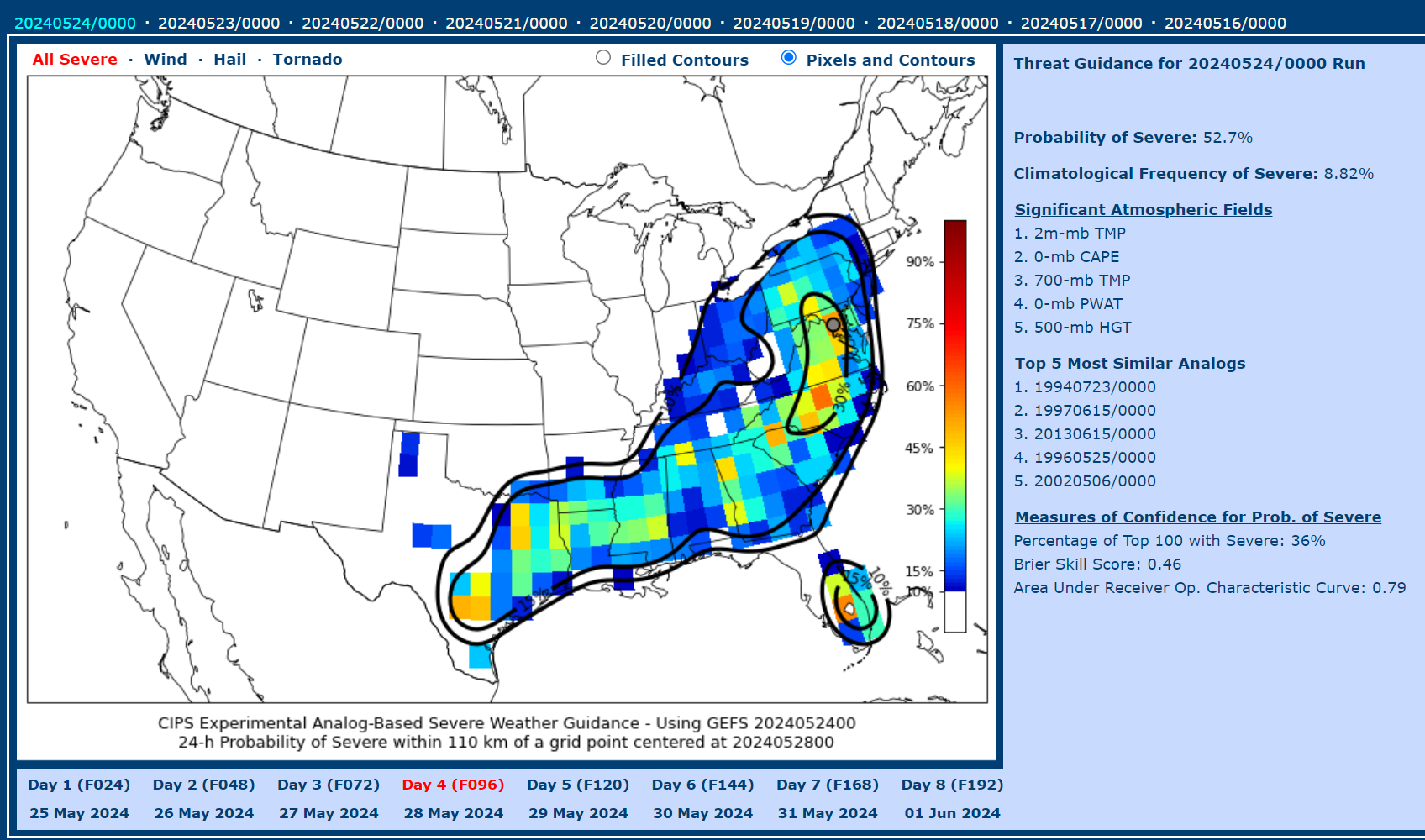
12z CIPS at hour 84..if you cheat a little and use the Southeast Domain instead of the one over us, April 29, 2002 at 0z is the top analog (La Plata event). Also one of the June 1998 beefy events showing up. Overall the CIPS guidance looks more robust at the 12z run versus the overnight run. I was pretty enthusiastic with how the Euro looks latest run too.
- 1,696 replies
-
- 2
-
-
- severe
- thunderstorms
- (and 5 more)
-
12z GFS backed wayyy off on the Monday threat. Instability looks much lower. This is why we can't "bank on" anything days out ahead. We'll see how things look later in the weekend.
-
June 2013 (the big event) is showing up in the analogs

- 1,696 replies
-
- 1
-
-
- severe
- thunderstorms
- (and 5 more)
-
The supercell composite maps have improved a decent bit from prior runs. If that continues to look good or even improve, I'll be on board. Still a bit too far out to be at all confident.
- 1,696 replies
-
- 2
-
-
- severe
- thunderstorms
- (and 5 more)
-
If @Amped is excited - that's usually a good indication for severe.
-
I wish had had a better memory of the sequence of late May to early June 1998. I wasn't THAT young...but for some reason I just can't remember specifics. My memory starts to become clearer starting around the Sept 2001 College Park tornado...but before that...really blurry if any memory at all. June 2008 seemed like a decent "heater" period along with June 2012.
-
October 18th of that year (1990) had an outbreak as well. Most of what I can find are write-ups that might not be DC area centered and archived articles from the WaPo and similar.
-
Using MBY in Silver Spring/Colesville as a point, the IEM SPC Outlook filtering guide shows *TEN* moderate risk days from May to October in 1990. Obviously, meteorology wasn't advanced as it was...but that was either a heck of a bust year or we were absolutely getting rocked and rolled. I wasn't born yet
-
CIPS is a little less enthusiastic on the 0z overnight run. But it will wax and wane I'm sure. I was doing some boredom research and it definitely looks like the idea that we go on heaters followed by long periods of "meh" severe weather is legit - at least judging solely by SPC outlook categories. I found some stretches in the 90s of heater runs of moderate risks in a month period. Wish I was old enough to distinctly remember those. SPC Outlook archives on their website only go back to 2000 - Googling can get you some but not a comprehensive list of pre-2000. Fun to do in free time. Nerds....we are.
- 1,696 replies
-
- 3
-
-
- severe
- thunderstorms
- (and 5 more)