

Kmlwx
-
Posts
13,549 -
Joined
-
Last visited
Content Type
Profiles
Blogs
Forums
American Weather
Media Demo
Store
Gallery
Everything posted by Kmlwx
-
@Maestrobjwa - Have never had an issue with you and I try really hard not to judge people's style and such. But I will say that I, for one do appreciate that over the last year or two you truly seem to have been trying to learn concepts and stuff. The biggest advice I will give you - and in no part of this post do I mean any malice or ill will - is that like you said in the other thread...weather is weather - we can't really change it or do anything about it. Weather doesn't care if you're due. Weather doesn't care if you "deserve" snow. Weather doesn't care if you got screwed by 50 snowstorms and are depressed. The best advice that I got when I started on Eastern in the 2000s was that you don't have to reply to every post or topic or concept. It's okay to just read. The more you post is not going to trigger the butterfly effect to "will" a snowstorm closer. It is OK to just let other folks carry the thread. I too get REALLY bummed out when we miss snowstorms. You'll notice that I largely go silent in the winter here - but I certainly am in here DAILY and quietly obsessing about the snow potential. I've gotten better over the years - but I will admit I in fact do get bummed when stuff doesn't work out. But I found a long time ago that the more I posted, the worse my "need" to have snow to be happy got. You have some options here - and it's not even a complete list. - Try new hobbies - I've been spotting foxes and animals in my backyard lately and it's been a blast with trailcams and stuff. Way higher success rate than snow chasing too! I also picked up plane spotting in the past few years. Again, not saying THOSE specifically, but they are both more redeeming a lot of times than weather tracking. - Get into more diverse weather. We fail a ton at summer/spring severe weather too...but at least by making it more flexible as to the type of weather that interests me - it's not just snow. - CHASE the snow if you have the means to do so. I know we can't all pack up like Bob Chill and go to multiple locations. But if you have the means, do it. We are unfortunately warming. We don't need to over that. But if you are solely attached to big snow that you "deserve" you're going to have deep depression in the years to come I fear. Gotta take the wins we get and hope for the best. No amount of posting or hand wringing is going to change what Mother Nature wants to do. But I want to reiterate - I truly appreciate that you've been trying to learn and improve.
-
 I peeked at the CPC analogs yesterday and yeah they were some turds.
 -
Don't tempt the weenies.
-
Omg!!! I haven't even been following since I submitted my entry. I was wondering why I got tagged in here. It won't hold
-
Will be sad to see this event end. Really nice day! Hopefully we don't go to shut the blinds for *too* long. Two over performers in one week is nothing to sneeze at, though
-
Already lightening up here in Colesville - streamer is losing a bit of the punch it seems. Not going to get to another half inch unless it picks up again. Just a bit of a refreshed dusting maybe tenth of an inch.
-
Flake size increased in this streamer (Colesville, MD). Last hurrah probably! Great way to end the day - probably iwll have to do a little light broom work on the driveway later on (shoveled earlier).
-
I think for today's event so far I ended up right around 4.5" Snow depth (including the leftovers from early week is like 6-7 inches depending on the undisturbed areas I checked.
-
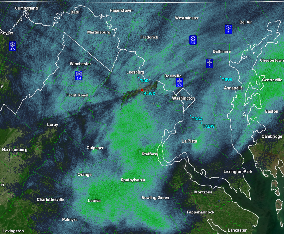
Streamers finally coming across the Potomac!
-
Do these just fall under the WSW or will they get snow squall warnings? Assuming it's just part of the WSW since it's already in effect for snow.
-
Light rates and sun through clouds. If you wanted it to stick around you shouldn't have shoveled
-
I want to get parked under a training streamer.
-
17z HRRR run continues the threat for those pop up snow showers/streamers later. They're going to be narrow - but somewhere within 15-20 miles of the Potomac seems like a good bit.
-
There's definitely some exposed road where the heaviest salt was now that rates are lighter and the sun is up higher. Unless I get under another band or it darkens a bit - the non snow covered surfaces aren't going to get stickage very well now.
-
This blob seems to have mainly been focused south and west of DC!
-
They won't. We are snow weenies and are mostly irrational. Ji might even put a turd in your mailbox or something.
-
Measurement area cleared again and measured an additional 1" since last clearing. Total of around 4" here in Colesville, MD so far. Radar looks more splotchy right now - but this is a great event given how it looked a mere few days ago. Wow! really pulling to get under a convective snow shower later on!
-
Round of shoveling done. So pretty outside. The existing snowpack definitely makes this overperformer even better.
-
I want to get under that streamer later this evening!
-
Ran out before it maybe picks up again and measured 3" on the nose here in Colesville. Cleared my measuring area.
-
Jan 19th Snow on Snow: the this always works until it doesn't thread
Kmlwx replied to psuhoffman's topic in Mid Atlantic
It's so the teachers can finish paperwork and submit grades and such. Teachers are already underappreciated enough - are they just supposed to do that in their personal time? -
Jan 19th Snow on Snow: the this always works until it doesn't thread
Kmlwx replied to psuhoffman's topic in Mid Atlantic
Were they the ones saying 1-2 or 1-3 for the other day? -
Jan Medium/Long Range Disco 2: Total Obliteration is Coming
Kmlwx replied to Jebman's topic in Mid Atlantic
Let's get two events in one week and then start big game hunting -
Jan 18-19 Storm Threat: Bob Chill made me do it
Kmlwx replied to stormtracker's topic in Mid Atlantic
It's fine because anything with @Bob Chill's name on it seems blessed by the snow gods. -
Jan Medium/Long Range Disco 2: Total Obliteration is Coming
Kmlwx replied to Jebman's topic in Mid Atlantic
You're such a rebel and we love you


