Kmlwx
-
Posts
13,549 -
Joined
-
Last visited
Content Type
Profiles
Blogs
Forums
American Weather
Media Demo
Store
Gallery
Everything posted by Kmlwx
-
TEAL72 is up out of Keesler for the next recon stint.
-

Tropical Storm Ophelia—Tropical Storm Warning for Coastal Mid-Atlantic
Kmlwx replied to WxWatcher007's topic in Mid Atlantic
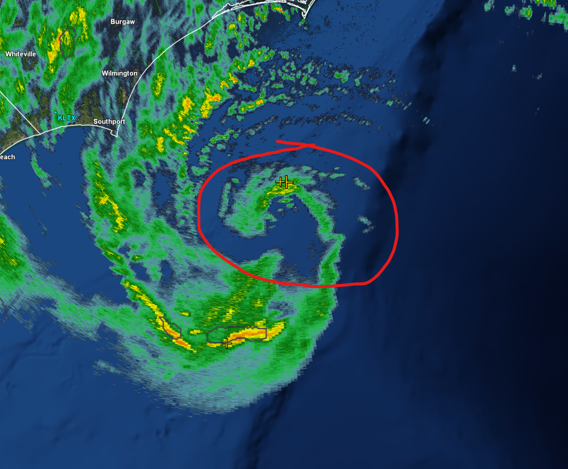
Has evolved pretty nicely in a short amount of time, actually.
-
Tropical Storm Ophelia—Tropical Storm Warning for Coastal Mid-Atlantic
Kmlwx replied to WxWatcher007's topic in Mid Atlantic
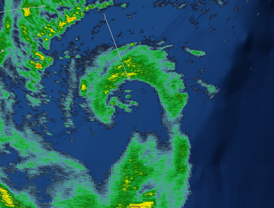
Maybe an eyewall trying to form? Some lightning in there as well!
-
Tropical Storm Ophelia—Tropical Storm Warning for Coastal Mid-Atlantic
Kmlwx replied to WxWatcher007's topic in Mid Atlantic
Also due to it being in transition by the time it gets up here. -
Tropical Storm Ophelia—Tropical Storm Warning for Coastal Mid-Atlantic
Kmlwx replied to WxWatcher007's topic in Mid Atlantic
Gusts, not sustained I believe -
Tropical Storm Ophelia—Tropical Storm Warning for Coastal Mid-Atlantic
Kmlwx replied to WxWatcher007's topic in Mid Atlantic
Did the center go/reform SW? -
Tropical Storm Ophelia—Tropical Storm Warning for Coastal Mid-Atlantic
Kmlwx replied to WxWatcher007's topic in Mid Atlantic
at the guy in the tropical forum thread saying that the shallow shelf waters were upwelled by Hurricane Lee wtf! -
Did you forget where Hurricane Lee went?
-
Tropical Storm Ophelia—Tropical Storm Warning for Coastal Mid-Atlantic
Kmlwx replied to WxWatcher007's topic in Mid Atlantic
Great sat pic! Imagine if it had some more time to get going. -
Tropical Storm Ophelia—Tropical Storm Warning for Coastal Mid-Atlantic
Kmlwx replied to WxWatcher007's topic in Mid Atlantic
-
Tropical Storm Ophelia—Tropical Storm Warning for Coastal Mid-Atlantic
Kmlwx replied to WxWatcher007's topic in Mid Atlantic
Stop summoning Ji. -
Tropical Storm Ophelia—Tropical Storm Warning for Coastal Mid-Atlantic
Kmlwx replied to WxWatcher007's topic in Mid Atlantic
Well and also discussions from NHC indicate it will get some baroclinic help. Not a "typical" system or pure tropical by any means. So if folks are looking at satellite and expecting a warm core red-meat beast - they going off of incorrect information. -
Tropical Storm Ophelia—Tropical Storm Warning for Coastal Mid-Atlantic
Kmlwx replied to WxWatcher007's topic in Mid Atlantic
Apologies if posted already - getting caught up -
-
The low is pretty far west...probably a lot of pinging if not 33 and rain
-
I figured as much - Mondays really suck. At least we likely will have *something* tropical to track probably
-
From yesterday? Or do you have a Time Machine to see today's 12z run?
-
Goalposts are essentially Texas to Spain at this point
-
Way, way, way wide right on the 6z run.
-
2023 Mid-Atlantic Severe Wx Thread (General Discussion)
Kmlwx replied to Kmlwx's topic in Mid Atlantic
In Odenton right now and it is pouring and storming. Loud thunder. Radar looks great for more.- 2,785 replies
-
- 1
-

-
- severe
- thunderstorms
- (and 3 more)
-
2023 Mid-Atlantic Severe Wx Thread (General Discussion)
Kmlwx replied to Kmlwx's topic in Mid Atlantic
Guidance looks pretty meh for today. -
2023 Mid-Atlantic Severe Wx Thread (General Discussion)
Kmlwx replied to Kmlwx's topic in Mid Atlantic
Extremely loud thunder in Colesville, MD -
2023 Mid-Atlantic Severe Wx Thread (General Discussion)
Kmlwx replied to Kmlwx's topic in Mid Atlantic
Really cool to see that stuff heading almost due north.- 2,785 replies
-
- 1
-
-
- severe
- thunderstorms
- (and 3 more)
-
2023 Mid-Atlantic Severe Wx Thread (General Discussion)
Kmlwx replied to Kmlwx's topic in Mid Atlantic
Enormous amount of lightning showing up on ENTLN and GOES Lightning Mapper on the storm form DC to College Park.- 2,785 replies
-
- 2
-
-
- severe
- thunderstorms
- (and 3 more)
-
2023 Mid-Atlantic Severe Wx Thread (General Discussion)
Kmlwx replied to Kmlwx's topic in Mid Atlantic
This activity looks like decent lightning producer(s). I'm guessing this stuff is elevated at this time of evening, though. -
2023 Mid-Atlantic Severe Wx Thread (General Discussion)
Kmlwx replied to Kmlwx's topic in Mid Atlantic
This is one of the weirder storm days in recent memory. Between the storm motions, the outflow not doing much in large parts of the area earlier - and now nocturnal storms.- 2,785 replies
-
- 2
-
-
- severe
- thunderstorms
- (and 3 more)