-
Posts
3,536 -
Joined
-
Last visited
Content Type
Profiles
Blogs
Forums
American Weather
Media Demo
Store
Gallery
Everything posted by Daniel Boone
-

Summer-Fall 2024 Weather Disco Med/Long Range
Daniel Boone replied to John1122's topic in Tennessee Valley
Yeah, it's as if CPC is running behind. I think Models had veen showing a wetter Pattern several days ago. Hopefully, that's not the case and they're onto something. If not, we're hurting around here. Drought, forest fires and damaged foliage.- 688 replies
-
- 1
-

-
- heat
- thunderstorms
- (and 7 more)
-

2024 Spring/Summer Mountain Thread
Daniel Boone replied to Buckethead's topic in Southeastern States
Definitely need something to change for this area. Quickly going into Drought conditions. Wound up with just .20 night before last. 0.73" for the Month. -

Summer-Fall 2024 Weather Disco Med/Long Range
Daniel Boone replied to John1122's topic in Tennessee Valley
.20 total here last night. Western and Northern portions of County got up to a half inch .- 688 replies
-
- 1
-

-
- heat
- thunderstorms
- (and 7 more)
-

2024 Spring/Summer Mountain Thread
Daniel Boone replied to Buckethead's topic in Southeastern States
Apparently, the HPC and NWS ain't buying it for whatever reason. Would be great if panned out. -
Oh yeah, clearly.
-
Yeah, unless something strange happens it's sure lined up that way.
-
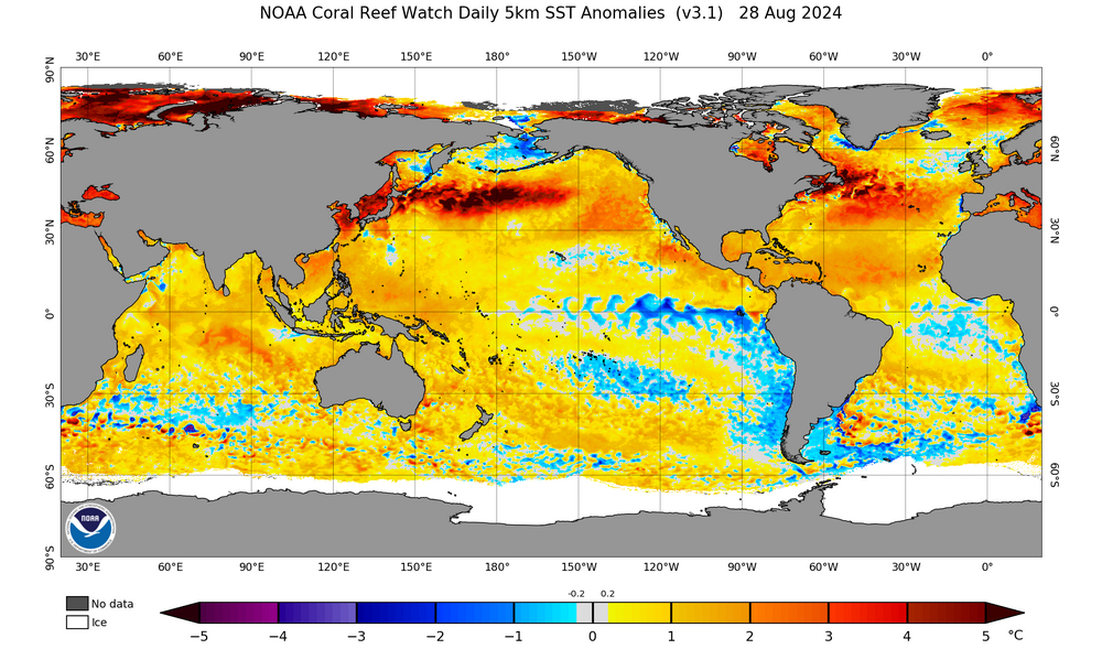
What about the warm SST'S off Newfoundland Chuck ? As we've seen in recent Winter's a 50-50 just can't get established there. I know this is not the main or sole driver of the -NAO but, does assist.
-

Summer-Fall 2024 Weather Disco Med/Long Range
Daniel Boone replied to John1122's topic in Tennessee Valley
43 here this AM. 42 just west of Town. General lower 40's. Hopefully that gulf tc will throw a monkey wrench in the dry pattern. If not, forest fires could become a problem as well as a crappy leaf peaking Season.- 688 replies
-
- heat
- thunderstorms
- (and 7 more)
-

2024-2025 Winter Ideas and Discussion
Daniel Boone replied to Carvers Gap's topic in Tennessee Valley
Good work Carvers ! Looks along my line of thinking as well. Hopefully we luck into a major late November or December Snowstorm. Along with all you detailed I will add the North Atlantic SST problem. We definitely need some major coolling of those SST'S off Newfoundland. Let's hope for some late season strong storms or TCs cross that area to help decrease those therefore enhancing the probability of 50-50 Lp setups in Winter. -

Summer-Fall 2024 Weather Disco Med/Long Range
Daniel Boone replied to John1122's topic in Tennessee Valley
Yeah, the cooler air had trouble infiltrating the great valley . Hit 79 here. Got short changed with Rainfall this last System, only .53 Total.- 688 replies
-
- heat
- thunderstorms
- (and 7 more)
-

Summer-Fall 2024 Weather Disco Med/Long Range
Daniel Boone replied to John1122's topic in Tennessee Valley
As we all know, 09-10 was a great Winter , cold and snow wise. However, it was a Nino as we know as well. The 05-06 Winter wasn't great overall in the upper east Tn and SW Va Valley areas as John touched on. Early to mid February did feature a couple decent 2-4 inch Snow events in the lower eles with more of course higher. Neither stayed on very long. Hopefully, the Nina continues to be a slow strengthening one. If it does I'd be confident of at least a decent Winter. However, as we have seen recently, the PDO and WPO have been playing havoc. Hopefully, changes within those areas will evolve to our benefit. Also, the SST'S off Newfoundland are boiling now. We need those to cool substantially.- 688 replies
-
- 2
-

-
- heat
- thunderstorms
- (and 7 more)
-

Mid to Long Range Discussion ~ 2024
Daniel Boone replied to buckeyefan1's topic in Southeastern States
Yeah, hopefully EC is wrong. It does have a warm bias so, may not be quite as hot as depicted if that Pattern is realized. The worry is that Ridge locking in for an extended period if it gets in that position. The extended hot/dry period in June and early July may be the similar outcome. -

Summer-Fall 2024 Weather Disco Med/Long Range
Daniel Boone replied to John1122's topic in Tennessee Valley
Thanks man. Glad you had that data. I couldn't find Pennington gaps. Did find their coldest August Temp recorded. 36 degree's. I recorded 38 August 26 , 1986 at my location near Pennington gap. Coldest I'd ever recorded in August.- 688 replies
-
- heat
- thunderstorms
- (and 7 more)
-

Summer-Fall 2024 Weather Disco Med/Long Range
Daniel Boone replied to John1122's topic in Tennessee Valley
in mid August 1976 Pennington gap recorded lows in the upper 40's on 3 occasions I believe. I know there were 2 days for sure. I'll try to find those records. That Month was so cool Maples began changing colors .- 688 replies
-
- 2
-

-
- heat
- thunderstorms
- (and 7 more)
-

Summer-Fall 2024 Weather Disco Med/Long Range
Daniel Boone replied to John1122's topic in Tennessee Valley
Yeah, that is what it is.- 688 replies
-
- heat
- thunderstorms
- (and 7 more)
-

Summer-Fall 2024 Weather Disco Med/Long Range
Daniel Boone replied to John1122's topic in Tennessee Valley
I know how you feel brother! Just hope we don't have to deal with those Sparrow size Mosquitoes.- 688 replies
-
- 1
-

-
- heat
- thunderstorms
- (and 7 more)
-

Summer-Fall 2024 Weather Disco Med/Long Range
Daniel Boone replied to John1122's topic in Tennessee Valley
Yeah, they need to reascess and update.- 688 replies
-
- 1
-

-
- heat
- thunderstorms
- (and 7 more)
-

Summer-Fall 2024 Weather Disco Med/Long Range
Daniel Boone replied to John1122's topic in Tennessee Valley
Moderate Flooding occurred yesterday in Cental and western Lee County. Creeks were out of banks in the Rose hill and Ewing area. These area's have received well over a foot of Rain over the last 3-4 weeks. I recorded 10.47 inches for the Month of July at my House 3 meles East of Jonesville. Currently at 2 inches for August. Area's in NE Lee County and Wise County have received much less.- 688 replies
-
- 3
-

-
- heat
- thunderstorms
- (and 7 more)
-

Mid to Long Range Discussion ~ 2024
Daniel Boone replied to buckeyefan1's topic in Southeastern States
Good Post. -

Summer-Fall 2024 Weather Disco Med/Long Range
Daniel Boone replied to John1122's topic in Tennessee Valley
Yeah, saw that on Radar earlier and was thinking that's in John's land.- 688 replies
-
- 1
-

-
- heat
- thunderstorms
- (and 7 more)
-

March/ Spring mid-long range
Daniel Boone replied to Holston_River_Rambler's topic in Tennessee Valley
Totally agree Jeff. Barring abundant Precipitation from TC activity, we'll look back and be thankful for all the early copious amounts of Rain. -

March/ Spring mid-long range
Daniel Boone replied to Holston_River_Rambler's topic in Tennessee Valley
Yeah, it's way low for here. I discussed this with KMRX several days ago. Basically echoes missing some of the precip and intensity here. I'm at 11.82" for the Month now. -

March/ Spring mid-long range
Daniel Boone replied to Holston_River_Rambler's topic in Tennessee Valley
11.69" of Rain for the Month as of 7 AM. -
Severe Storm hit at my home this afternoon producing dime size Hail and flooding. I measured 4.33" of Rainfall from the storm. 4.04" fell in an hour and 15 minutes . Numerous driveways washed out , mudslides aling with fallen Tree's. Some strong winds as well with downed limbs.
-

Winter 23-24' Wx Observations Thread
Daniel Boone replied to Carvers Gap's topic in Tennessee Valley
Same here. Particularly North and Eastern sections of the County.


