

Daniel Boone
-
Posts
3,542 -
Joined
-
Last visited
Content Type
Profiles
Blogs
Forums
American Weather
Media Demo
Store
Gallery
Everything posted by Daniel Boone
-

December 2020 Medium/Long Term Pattern Discussion.
Daniel Boone replied to John1122's topic in Tennessee Valley
Exactly the option we discussed that would get it done John. More than likely will be wavering back and forth between the two alot. Saw where CPC Totally bought yesterday's solutions. Not surprising though, as percentage odds and recent climate persistence trends would dictate that from them. -
December 2020 Medium/Long Term Pattern Discussion.
Daniel Boone replied to John1122's topic in Tennessee Valley
Yeah, for sure John. Still some hope for last nights depiction to be possible, with enough NA blocking and that NE PAC warm pool as Carver aluded to. But, with the Nina, in particular it's strength, this new depiction has greater odds of happening i.m.o, unfortunately . Maybe, it'll be more back and forth between the 2. If so, we can work with that. -
December 2020 Medium/Long Term Pattern Discussion.
Daniel Boone replied to John1122's topic in Tennessee Valley
My thoughts are exactly with Carvers. That NE PAC warm pool along with HLB are fighting any Niña takeover . IF Eps later depiction is right, it appears HLB may gradually force that vortex in the Yukon south. Probably down into south central Canada then who knows from there. Down into US or into eastern Canada. -
December 2020 Medium/Long Term Pattern Discussion.
Daniel Boone replied to John1122's topic in Tennessee Valley
Gotcha ! Thanks for the clarification. I expect back and forth as well. MJO does rule the roost many,( if not most, times ) tbh. -
December 2020 Medium/Long Term Pattern Discussion.
Daniel Boone replied to John1122's topic in Tennessee Valley
Same things were brought up back in '95-96 Fred as well as 2010-11 and a couple Factors warred against the full La Niña pattern takeover . Oh yes, it did try especially in 95-96 as short lived bouts of mild would come east only to be shunted by strong blocking in the NAO domain and other areas as Carver aluded to. Of course, Niña was weak that season so, odds are less favorable for that yo happen now and more in favor of more niña influence. However, what about 2010-11 ? Strong Niña but, remained cold overall in the East. Blocking was one reason. What was the others ? -
Oak Moon Upslope/ Upper Low Storm Obs
Daniel Boone replied to Holston_River_Rambler's topic in Tennessee Valley
Portions of Lee County received a good bit more than those reports. Problem is, very few report from here. Rose Hill for instance received 2.5 inches . Ben hur, 2" . I took measurements. The .80 was mine at 7 a.m...another .7 fell after that.- 300 replies
-
- 3
-

-

-
- upslope snow
- upper level disturbance
- (and 3 more)
-
December 2020 Medium/Long Term Pattern Discussion.
Daniel Boone replied to John1122's topic in Tennessee Valley
Noticed Dierks on WCYB this evening mentioned just a low chance of a turn over at the end for end of week system and showed a model run. He is a good Met and guy but, is warm biased. -
Oak Moon Upslope/ Upper Low Storm Obs
Daniel Boone replied to Holston_River_Rambler's topic in Tennessee Valley
Lee County totals varied from under an inch to several. Jonesville, 1 to 1.5" . Rose Hill 2.5, Ben Hur 2". Pennington gap 1.5. More on mountains, of course.- 300 replies
-
- 2
-
-
- upslope snow
- upper level disturbance
- (and 3 more)
-
Oak Moon Upslope/ Upper Low Storm Obs
Daniel Boone replied to Holston_River_Rambler's topic in Tennessee Valley
Latest update from kmrx has no accumulation for Knoxvegas. Not surprising though.- 300 replies
-
- 2
-
-
- upslope snow
- upper level disturbance
- (and 3 more)
-
December 2020 Medium/Long Term Pattern Discussion.
Daniel Boone replied to John1122's topic in Tennessee Valley
Feb. 2015 was epic and was going against the grain, so to speak. -
Oak Moon Upslope/ Upper Low Storm Obs
Daniel Boone replied to Holston_River_Rambler's topic in Tennessee Valley
Lt rain in Kingsport still. Just leaving there geading back home. Inlaws said snowing in Jonesville.- 300 replies
-
- 2
-
-
-
- upslope snow
- upper level disturbance
- (and 3 more)
-
Oak Moon Upslope/ Upper Low Storm Obs
Daniel Boone replied to Holston_River_Rambler's topic in Tennessee Valley
Light snow coming down steady 1800 and up on Powell Mountain, Lee/Scott County line.- 300 replies
-
- 3
-
-
- upslope snow
- upper level disturbance
- (and 3 more)
-
Oak Moon Upslope/ Upper Low Storm Obs
Daniel Boone replied to Holston_River_Rambler's topic in Tennessee Valley
Wonder what's causing the drop off in parts of Eastern KY on Rap ? Looks rather odd.- 300 replies
-
- 1
-
-
- upslope snow
- upper level disturbance
- (and 3 more)
-
Oak Moon Upslope/ Upper Low Storm Obs
Daniel Boone replied to Holston_River_Rambler's topic in Tennessee Valley
That should allow for more system generated Snowfall for the area.- 300 replies
-
- 1
-
-
- upslope snow
- upper level disturbance
- (and 3 more)
-
Oak Moon Upslope/ Upper Low Storm Obs
Daniel Boone replied to Holston_River_Rambler's topic in Tennessee Valley
It looks NAM generated.- 300 replies
-
- 1
-
-
- upslope snow
- upper level disturbance
- (and 3 more)
-
December 2020 Medium/Long Term Pattern Discussion.
Daniel Boone replied to John1122's topic in Tennessee Valley
If today's GFS Operational comes to fruition, our cold/snow after 2morrow and Tuesdays went in the crapper! Flip flop from last several days. -
Oak Moon Upslope/ Upper Low Storm Obs
Daniel Boone replied to Holston_River_Rambler's topic in Tennessee Valley
That's a rather "cheesy " looking forecast. They can do better than that. -
December 2020 Medium/Long Term Pattern Discussion.
Daniel Boone replied to John1122's topic in Tennessee Valley
Y -
December 2020 Medium/Long Term Pattern Discussion.
Daniel Boone replied to John1122's topic in Tennessee Valley
What a boobyful Map ! -
December 2020 Medium/Long Term Pattern Discussion.
Daniel Boone replied to John1122's topic in Tennessee Valley
They're pretty much always conservative. I'll say this, IF there's strong nw flow off the lakes and enuff steep lapse rates, I guarantee much more than they're showing. NW flow alone would yield more than 2 inches in places like Wise, Va for example.. -
December 2020 Medium/Long Term Pattern Discussion.
Daniel Boone replied to John1122's topic in Tennessee Valley
This is the one we're rooting for Carvers. CMC actually did better here the last couple seasons than the others a few times. -
December 2020 Medium/Long Term Pattern Discussion.
Daniel Boone replied to John1122's topic in Tennessee Valley
One thing of note, especially with LR modeling is the heavy weighting of ENSO. So, this could be alot of the shifting to the western trough. Of course, may very well happen and of course with the strength of La niña, odds favor that. -
December 2020 Medium/Long Term Pattern Discussion.
Daniel Boone replied to John1122's topic in Tennessee Valley
Agree John. Also, measurements were taken different back then by some. They would measure after snow ended and settled. Also, during drifting events they would measure the leveled or lowest area instead of different locations for an average. -
December 2020 Medium/Long Term Pattern Discussion.
Daniel Boone replied to John1122's topic in Tennessee Valley
Here ya go guys. That one ruled the roost here as far as November Snowstorms. A true Blizzard ! Cars were completely covered here in Lee County from huge drifts . Higher eles. of County received 2 ft.+. Drifts much higher. Temps were in teens during day.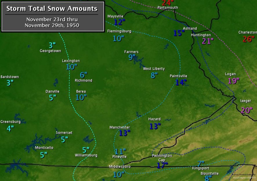
-
Fall/Winter Banter - Football, Basketball, Snowball?
Daniel Boone replied to John1122's topic in Tennessee Valley
4" here from that last year.