

high risk
-
Posts
2,915 -
Joined
-
Last visited
Content Type
Profiles
Blogs
Forums
American Weather
Media Demo
Store
Gallery
Everything posted by high risk
-
I’m cautiously optimistic for some thunder this evening, but the soundings don’t excite me for severe potential. That said, wind would certainly be on the table if we can maintain some surface-based instability ahead of whatever convection makes it to our area.
- 1,696 replies
-
- 1
-

-
- severe
- thunderstorms
- (and 5 more)
-
The signal is even stronger in this evening's runs. Almost every CAM has some light precip early Tuesday, and temperatures are just below freezing, except for the HiRes Window FV3 which is known to poorly handle low-level inversions. Given that temperatures will be very cold leading into this event, I would expect surfaces to be very cold, and icing would be a problem even for areas right around 31 or 32. Certainly worth additional tracking.
-
Also a marginal risk for damaging winds for the eastern parts of the area, per the updated Day 3 SPC outlook
-
You say that NHC runs its own models which are not prone to big errors; you might be surprised to learn that the primary hurricane models are actually generated by the same U.S. center that generates the models you hate so much. And those hurricane models actually use the same model core as the primary U.S. medium range model that drives you nuts. And those hurricane model forecasts, and NHC, bust far more often that you realize. Criticize models to your heart's content, but your 48 cent takes on what models are and how they're developed and run is tiresome.
-
We get that you don't like computer forecasting models, but could you please stop spouting pure nonsense about them?
-
It's a nice little forced line just ahead of the cold front. It's there on the HiResW FV3 as well, but that model is warmer and verbatim has heavy showers that might end as a burst of snow.
-
I appreciate what you're trying to say here, and you were very much on the right track in saying that a small error at the start can lead to a massive error downstream 10 days later. But you can't design a model like the GFS with "bumpers". You can absolutely mitigate extreme solutions with bias-corrected, calibrated products, but the actual model solutions are what the model integration leads to.
-
The reason is that, despite what one unnamed poster thinks, models are not driven by analogs and don't have climatological factors. You start with an initial state and integrate the equations forward, and they take the solution wherever they take it.
-
 HRRR has the center of the upper low arriving Thursday afternoon with scattered to numerous heavy showers. This sounding sure suggests that small hail or graupel would be possible in any of the stronger cores.
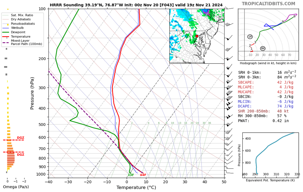
- 728 replies
-
- 10
-
-

-
I see what you did there.
-
Seems to be some growing consensus that there will be a significant east-west gradient of precip. Folks west of the Potomac are in way better shape than those of us on the east side,
-
The real push of drier air isn't until Saturday morning. Models disagree about exactly how dry Thursday and Friday will be (some of the CAMs show a fair amount of low clouds, while the GFS is more optimistic. The weekend is then really good, although somewhat higher dew points return Sunday afternoon in advance of the next front. This front passes early Monday, and it's the real deal. 60s for Tuesday on most guidance with lows in the 40s.
-
Hurricane Helene: Remnants Impact to Mid-Atlantic
high risk replied to WxUSAF's topic in Mid Atlantic
Convective elements should be rolling through the DC metro area early this evening. While surface-based instability should be negligible, the low-level shear will be very strong with impressive hodographs. I can't rule out a very brief spin-up, or at least a tornado warning or two necessitated by modest storm rotation, although the chances of reaching the ground are likely small unless the surfaced-based instability is slightly higher than progged. -
Hurricane Helene: Remnants Impact to Mid-Atlantic
high risk replied to WxUSAF's topic in Mid Atlantic
Simulated reflectivities Friday don't look particularly impressive, but we'll be in a high PW environment for a chunk of the day, so some over performing rainfall totals are certainly on the table. -
Exactly. Even when the HRRR initialized it well: It dramatically weakened within only one hour: When this happens, it's a clear indication that the forcing to drive the rain area is largely not being captured in the model. It has no reason to think that heavy, organized rain should be there, and it works to wipe it out.
-
Definitely not handled well at all by the guidance. Closing in on 1” here.
-
Already 1/3 of an inch here, and I haven't even gotten into the "good stuff" for more than a few minutes. This is not how convection usually behaves here after dark, but the shortwave looks great in the guidance. Should be some very impressive totals in north-central and northeast MD overnight.
-
Heavy 11pm shower at my home. The main batch up in PA looks to be headed for northeast MD. We'll see if there is back building on the western flank as it comes south.
-
The best shot at a soaking in the Baltimore area was always round 2, after midnight. Last several runs of the HRRR really like central and northeast MD.
-
That’s my worry for sure, but we still have a shot at something from the evening batch.
-
I'll say this: with that NAM3 focus of heaviest rain, there is some (but not complete) model agreement for northeast MD to get soaked early Sunday
-
Seems to be some modest model agreement in a small MCS (or closer of cells) coming into the DC area in the very late afternoon or early evening hours. Perhaps less certainly for north-central Maryland. Second batch of showers, covering some part of the area, towards sunrise.
-
Agreed. Looks more like a Saturday frontal band now, and while it does appear to have decent moisture and convergence, such that we might maximize its potential, it's not the overrunning soaker we wanted.
-
I understand the SLGT, but it's highly conditional, as several of the CAMs are a shutout for most of the area. It would be a late threat if it materializes, possibly after sunset for the central MD crew.
-
1.15” in southern Howard County

