

high risk
-
Posts
3,280 -
Joined
-
Last visited
Content Type
Profiles
Blogs
Forums
American Weather
Media Demo
Store
Gallery
Everything posted by high risk
-

2026 Mid-Atlantic Severe Storm General Discussion
high risk replied to Kmlwx's topic in Mid Atlantic
It was interesting how the overnight runs looked pretty good, and then the 12Z suite (and a HRRR cycle or two after that) didn't look as good, before the HRRR locked on to the solution by late morning. And I'll be curious to see how many tornadoes are actually found. There were probably way more warnings than needed, but I'm wondering if they'll find more than the current count of one (good video of a tornado on the Eastern Shore north of Cambridge). Ultimately, we probably weren't far off from a more significant tornado event, but as you suggested in your post, the low-level winds were probably just a bit too weak, although I think that the low-level profile was slightly better than what the RRFS and GFS/ECMWF were suggesting last night.- 1,687 replies
-
- 3
-

-
- severe
- thunderstorms
- (and 7 more)
-
2026 Mid-Atlantic Severe Storm General Discussion
high risk replied to Kmlwx's topic in Mid Atlantic
The guidance trends were really interesting. Things were looking encouraging for fairly significant storms in the early runs on Tuesday, and then the cycles right after the raob data became available looked fairly lousy (as noted in your post). Then, the HRRR started locking in again on the more significant solutions. -
2026 Mid-Atlantic Severe Storm General Discussion
high risk replied to Kmlwx's topic in Mid Atlantic
You're not exactly going out on a limb with that prediction.... -
2026 Mid-Atlantic Severe Storm General Discussion
high risk replied to Kmlwx's topic in Mid Atlantic
Sort of. That day involved some local storms that initiated followed by the main band along the forcing arriving from the northwest during the evening hours. This looks to be a line forming just to our northwest during the early/mid afternoon and rolling through at dinner time before making a quick exit. There is some curvature in the hodographs, so the tornado threat is definitely non-zero, although the forcing may result in a more linear structure. The box will go up for northern sections first, because there is good cam agreement on an initial wave of storms for northeast MD/PA/NJ earlier this afternoon.- 1,687 replies
-
- 1
-

-
- severe
- thunderstorms
- (and 7 more)
-
2026 Mid-Atlantic Severe Storm General Discussion
high risk replied to Kmlwx's topic in Mid Atlantic
The evening cams don't fully sort out the details, but if we look for some modest consensus, the morning MCS threat for most of us has decreased a lot. And the severe threat ramps up quickly after lunch. Even if some cloud cover reduces the heating, I don't think that's a big deal unless we stay really cool. Full heating is not critical to this event, because we have forcing and good shear. Some solutions still screw us in terms of coverage and rainfall, but again, I'm looking for some sort of consensus, and the screw outcomes are on the table but seemingly less likely. Oh, and there is case to be made for including a corridor bounding roughly Rocky Mount, NC to Harrisburg to Trenton and all points to the east with a tornado threat (5%). SPC might keep our local area in a 2, but a 5 would be justifiable, as some solutions keep the sfc low just to our west or northwest with modestly increasing low level flow during the afternoon beneath strengthening west-northwest mid-level flow..- 1,687 replies
-
- 7
-
-
- severe
- thunderstorms
- (and 7 more)
-
2026 Mid-Atlantic Severe Storm General Discussion
high risk replied to Kmlwx's topic in Mid Atlantic
It was not an obvious tornado day either, and in fairness to the forecast, that appears to be the only high-end tornado event today. (Yes, there was more widespread wind damage). It unfortunately got its act together in a very populated area.- 1,687 replies
-
- 1
-
-
- severe
- thunderstorms
- (and 7 more)
-
2026 Mid-Atlantic Severe Storm General Discussion
high risk replied to Kmlwx's topic in Mid Atlantic
I think so too, but this is still really complicated, and the 12Z suite hasn't locked in on anything yet. It *does* seem like while the main MCS will be west of here in the morning hours, some piece of it will approach and probably strengthen a bit. If it arrives around commute time, it will probably be sub-severe, but if it's mid-morning, severe is possible. Guidance then differs sharply on how much heating will occur behind any morning activity, but how much will it matter. Steepening lapse and strong forcing might compensate for limited surface heating. At least scattered storms are likely by mid-afternoon, and some solutions are widespread. All hazards would be possible; the low-level winds are probably too weak for tornadoes, but the directional shear will be there, so it wouldn't take much to increase the tornado threat.- 1,687 replies
-
- 6
-
-
- severe
- thunderstorms
- (and 7 more)
-
2026 Mid-Atlantic Severe Storm General Discussion
high risk replied to Kmlwx's topic in Mid Atlantic
I'd usually agree with you. But as we now move into CAM range, recognizing that the U.S. CAMs all have some influence of the GFS, the solutions seem to be favoring the GFS more. The idea of a deep sfc low over the St Lawrence Valley isn't dead in the Euro, but even its AI version likes a secondary low in the Mid-Atlantic. Verbatim, some pretty strong forcing rolls through during the morning and midday hours, which screams flash flooding more than severe. That said, 1) a surface low will be nearby, so you always need to watch for a tornado threat, especially if we can heat up before the forcing arrives 2) there is time to change some of the synoptic details- 1,687 replies
-
- 4
-
-

-
- severe
- thunderstorms
- (and 7 more)
-
Multiple CAMs break out scattered showers (thunder?) in the area Sunday afternoon lasting into the evening.
-
2026 Mid-Atlantic Severe Storm General Discussion
high risk replied to Kmlwx's topic in Mid Atlantic
The Euro is a legit severe solution for Tuesday. The GFS screams "dying MCS moves through at 9AM and kills off the afternoon threat".- 1,687 replies
-
- 3
-
-
- severe
- thunderstorms
- (and 7 more)
-
HRRR wants to bring another line through the area in a few hours. Verbatim, it's mainly for areas south of DC, but there are certainly cells further north in eastern WV than modeled.
-
2026 Mid-Atlantic Severe Storm General Discussion
high risk replied to Kmlwx's topic in Mid Atlantic
The radar west of Philly is what our radar was supposed to look like now -
2026 Mid-Atlantic Severe Storm General Discussion
high risk replied to Kmlwx's topic in Mid Atlantic
I don't like seeing that east-west line to our south at all. -
2026 Mid-Atlantic Severe Storm General Discussion
high risk replied to Kmlwx's topic in Mid Atlantic
It might temper the severe threat somewhat, but getting significant storms seems to still be on track. Each HRRR cycle this morning has been catching on to the fact that we won't get the amount of heating previously expected, and it still initiates widespread heavy convection.- 1,687 replies
-
- 3
-
-
- severe
- thunderstorms
- (and 7 more)
-
2026 Mid-Atlantic Severe Storm General Discussion
high risk replied to Kmlwx's topic in Mid Atlantic
Heating is obviously a concern, but assuming we bust out into some partial clearing by late morning, HRRR and RRFS both have a couple of interesting lead cells followed by a squall line feature.- 1,687 replies
-
- 3
-
-
- severe
- thunderstorms
- (and 7 more)
-
2026 Mid-Atlantic Severe Storm General Discussion
high risk replied to Kmlwx's topic in Mid Atlantic
SPC issued MDTs on back to back days with Ivan. The first day over the southeast somewhat busted, as too much cloud cover limited instability. On the second day, we did eventually get a MDT into parts of northern VA, but the threat was not obvious until it evolved in real time. This was the initial outlook of the day. The area with a 5% got a SLGT. (The probabilities ramped up starting with the 1630Z outlook.)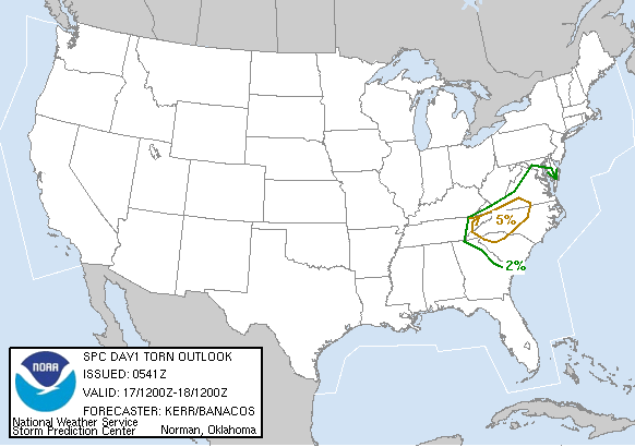
- 1,687 replies
-
- 2
-
-
- severe
- thunderstorms
- (and 7 more)
-
2026 Mid-Atlantic Severe Storm General Discussion
high risk replied to Kmlwx's topic in Mid Atlantic
Sign me up for the 00Z HRRR.- 1,687 replies
-
- 5
-
-
-
- severe
- thunderstorms
- (and 7 more)
-
This isn't true at all. All NWS gridded forecasts use the NBM which combines lots of available computer models. For Days 4-7, WPC can make some minimal edits and get some input from WFOs, but they mostly leave the NBM alone. For Days 0-3, the WFOs can be a bit more heavy-handed, but they are still encouraged to limit their editing.
-
Beyond day 3 is generated using the NBM, but WPC is allowed to make some minor edits (with input from the local offices). It is NOT AI-based.
-
2026 Mid-Atlantic Severe Storm General Discussion
high risk replied to Kmlwx's topic in Mid Atlantic
There has been a clear trend in the guidance for more favorable timing for our area.- 1,687 replies
-
- 5
-
-
- severe
- thunderstorms
- (and 7 more)
-
2026 Mid-Atlantic Severe Storm General Discussion
high risk replied to Kmlwx's topic in Mid Atlantic
I like what I see in the CAMs that go out to Tuesday evening (NAM Nest, HiResW FV3, RRFS). Multiple rounds of storms on a pre-frontal trough / wind shift, and possibly another line in the evening (although I suspect our environment will be worked over from the afternoon storms). Environmental parameters are solid. And for those looking to maximize rainfall, we could see an early round of storms late Monday night or early Tuesday morning as the warm front lifts to the northeast.- 1,687 replies
-
- 5
-
-
- severe
- thunderstorms
- (and 7 more)
-
2026 Mid-Atlantic Severe Storm General Discussion
high risk replied to Kmlwx's topic in Mid Atlantic
Getting enough low-level shear was always in doubt for this event, especially once the warm front quickly retreated to the northeast during the late morning hours. The mid-level wind speeds underperformed a bit, relative to guidance, but there should have been enough deep-layer shear for fairly widespread wind, given the magnitude of the instability. I think you're correct that the profile was overall too moist to achieve a high end wind event. -
2026 Mid-Atlantic Severe Storm General Discussion
high risk replied to Kmlwx's topic in Mid Atlantic
Looks somewhat similar to today, with perhaps weaker instability but better wind fields. Same idea of a poorly-timed front, but plenty of storms forming on a lee or some other type of pre-frontal trough.- 1,687 replies
-
- 1
-
-
- severe
- thunderstorms
- (and 7 more)
-
2026 Mid-Atlantic Severe Storm General Discussion
high risk replied to Kmlwx's topic in Mid Atlantic
All of what you said is legit, but I'm leaning now towards the idea that this was an artifact. As you said, getting a strike super far away from the core is possible, but I think you need a much more powerful setup than we had today. -
2026 Mid-Atlantic Severe Storm General Discussion
high risk replied to Kmlwx's topic in Mid Atlantic
Yeah, the good low-level shear is closer to the warm front in NJ.