high risk
-
Posts
3,240 -
Joined
-
Last visited
Content Type
Profiles
Blogs
Forums
American Weather
Media Demo
Store
Gallery
Everything posted by high risk
-
You're too kind. Easy to make a call on this when you have a strong upper trough axis swinging through with lapse rates like these:
-
Nice signal in the NAM nest for some heavy rain/snow/grapuel showers later Saturday as the trough axis swings through with steep lapse rates.
-
I don't have enough fingers to count the number of dead-wrong statements in this post.
-
There are two machines: one in Orlando and one in Reston. One of them is the production machine, and one is the development machine, but they switch back and forth.
-
https://www.emc.ncep.noaa.gov/users/meg/gfsv16/realtime/gfsximages.html It looks like the original post was indeed referring to an older run, but the latest run does have a coastal around the 4th (although it's not a snowstorm, verbatim.)
-
Yep. Big upgrade in early December. https://www.emc.ncep.noaa.gov/users/meg/rapv5_hrrrv4/
-
Yeah, that's fair. It just feels like LWX likes to warn on these things a lot, and the false alarm rate is super high. For this event, I'd rather wait for a report to come in before pulling the trigger, although it's easy for me to say that without my neck on the line.
-
I'm struggling to understand the severe warning, as while that's an impressive feature on radar, it shouldn't be surface-based and therefore unable to get the winds to the ground. But I'm prepared to be wrong....
-
Definitely thunder. We had a severe thunderstorm watch that afternoon.
-
I lost track trying to count the number of incorrect details in this post.
-
While it's a bit unclear how much precip will linger immediately behind the front (for a brief period of sleet or snow early Christmas morning in the DC metro area), there may be more hope for a period of snow showers during Christmas Day as the upper trough axis swings through, and low-level lapse rates steepen. There is a very weak signal in the NAM nest, but there is a smack-you-in-the-face-with-a-small-snowball signal in the 18z HRRR.
- 616 replies
-
- 11
-

-

2020 Mid-Atlantic Severe Weather - General Thread
high risk replied to Kmlwx's topic in Mid Atlantic
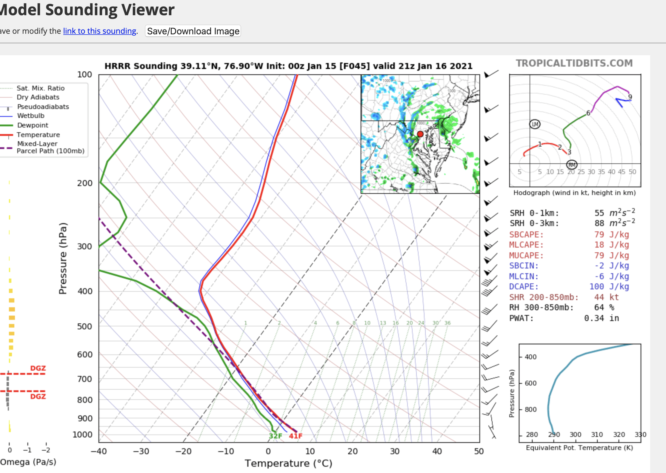
You're absolutely correct about the very strong winds above the surface and the intense forcing that will be present. But that sounding is not one that would promote strong winds mixing to the ground. There is the slightest hint of mixing in a very shallow layer at the ground, but you do have an inversion above that, and the box below the sounding explicitly shows 0 sfc-based CAPE. The reason you see some impressive convective signatures in the guidance is the strong lift with the PVA and the front. There is also a little bit of elevated instability (the most unstable CAPE is listed as around 430) to assist. To be clear, though, if we can end up a few degrees higher on both the temperature and dew point, we might then have a legitimate threat to have sfc-based storms that are capable of strong wind gusts. -
2020 Mid-Atlantic Severe Weather - General Thread
high risk replied to Kmlwx's topic in Mid Atlantic
It's definitely worth watching Christmas Eve with likely intense shear profiles and forcing, but right now, it just doesn't look like we're going to be able to squeeze out any sfc-based instability. -
December 16-17, 2020 Winter Storm Obs/Nowcasting
high risk replied to WxUSAF's topic in Mid Atlantic
This band moving through Montgomery County and the northern part of DC is the last hurrah. -
December 16-17, 2020 Winter Storm Obs/Nowcasting
high risk replied to WxUSAF's topic in Mid Atlantic
I am on board with those chances, but if you look at the simulated radars, the stuff near RNK actually comes through as another round of RA/IP/ZR later this evening. The potential snow band just after midnight seems to form out over eastern WV with the upper trough axis and then rotates through our area. -
December 16-17, 2020 Winter Storm Obs/Nowcasting
high risk replied to WxUSAF's topic in Mid Atlantic
some modest glaze on the trees here in southern Howard County -
December 16-17, 2020 Winter Storm Obs/Nowcasting
high risk replied to WxUSAF's topic in Mid Atlantic
for the Columbia crowd, it has now gone to sleet here in North Laurel after close to 2" of snow. So enjoy the SN+ while you can. -
December 16-17, 2020 Winter Storm Obs/Nowcasting
high risk replied to WxUSAF's topic in Mid Atlantic
nothing. The hourly maps show a lot of sleet in the DC-NYC corridor, and the snow map simply applies a 10:1 ratio to the liquid amount being generated if it's snow OR sleet. -
December 16-17, 2020 Winter Storm Obs/Nowcasting
high risk replied to WxUSAF's topic in Mid Atlantic
As you noted, the core was changed, but most of the actual physics (except for the microphysics) were retained. I think that the PBL scheme plays a role in these warm layer cases. -
December 16-17, 2020 Winter Storm Obs/Nowcasting
high risk replied to WxUSAF's topic in Mid Atlantic
It's the "new" GFS, but it has the old physics, so I suspect that its inability to capture mid-level warm layers remains. -
December 16-17, 2020 Winter Storm Obs/Nowcasting
high risk replied to WxUSAF's topic in Mid Atlantic
The regular members of this subforum are perfectly capable of making uninformed posts, without the need for any outside help, but thanks. -
December 16-17, 2020 Winter Storm Obs/Nowcasting
high risk replied to WxUSAF's topic in Mid Atlantic
Agreed on all counts. The GFS typically shows way too small of a small transition zone between rain and snow. I do think that eastern Howard may get a decent sleet mess out of this. -
December 16-17, 2020 Winter Storm Obs/Nowcasting
high risk replied to WxUSAF's topic in Mid Atlantic
It's worth noting that in the CAMs (especially the NAM nest) that turn central and north-central MD over to sleet for a long duration, the warm layer is up around the 750 or 700 mb level. The GFS is typically very poor at capturing those warm layers if they're well above, say, the 850 level. PSU made a reference earlier to the March 2017 storm in which the GFS missed forecasting most of the sleet because it kept things much colder aloft. It isn't the same GFS now, but I would not be surprised if this weakness holds. -
December 16-17, 2020 Winter Storm Obs/Nowcasting
high risk replied to WxUSAF's topic in Mid Atlantic
the front end thump for those of us in Howard/Montgomery isn't nearly as good on the NAM nest -
December 16-17, 2020 Winter Storm Obs/Nowcasting
high risk replied to WxUSAF's topic in Mid Atlantic
100% true for this area. Well, ok, 90% true.