high risk
-
Posts
3,240 -
Joined
-
Last visited
Content Type
Profiles
Blogs
Forums
American Weather
Media Demo
Store
Gallery
Everything posted by high risk
-

Feb Long Range Discussion (Day 3 and beyond) - MERGED
high risk replied to WinterWxLuvr's topic in Mid Atlantic
GFS para is a T-H-U-M-P. Over 1" of liquid in the 12 hours ending at 18z Thursday. -
Feb Long Range Discussion (Day 3 and beyond) - MERGED
high risk replied to WinterWxLuvr's topic in Mid Atlantic
Yeah, it doesn't have a systematic cold bias overall, but it can run a bit cold in terms of trying to cool columns in marginal winter events with strong lift. It's also worth noting that it can overdo the strength of the warm nose, usually by cranking up and veering the flow too much between 850 and 700. I know we're all looking for reasons to toss its solution that really minimizes the front end thump of snow Thursday. While it's justifiable to note several times this winter when it has sniffed out some important trends, the NAM feels like a bit of synoptic outlier right now, although I would absolutely not put any money on that. -
Feb Long Range Discussion (Day 3 and beyond) - MERGED
high risk replied to WinterWxLuvr's topic in Mid Atlantic
Honestly, I just threw in that "outside the DC Beltway" disclaimer to match details of the GFS para output that are worthless at this range. I can't figure out why it has snow on either side of DC at the start with sleet over DC, but I'd think that DC is still in the game for at least a minor initial thump, and with the trends you note, maybe we can aim even a bit higher. -
Feb Long Range Discussion (Day 3 and beyond) - MERGED
high risk replied to WinterWxLuvr's topic in Mid Atlantic
That's a good point. When the ops GFS shows a decent cold air damming signal, you have to take notice, as it loves to mix things out quickly and switch the winds to a southerly component. Both versions of the GFS (and other guidance) have a signal of a weak low trying to form along the coast - that setup with a dying low coming in from the west and a weak system forming to our east or southeast (has to be weak to not crank up the onshore flow) usually works very well for damming. -
Feb Long Range Discussion (Day 3 and beyond) - MERGED
high risk replied to WinterWxLuvr's topic in Mid Atlantic
correct. Still not great but a clear step forward. -
Feb Long Range Discussion (Day 3 and beyond) - MERGED
high risk replied to WinterWxLuvr's topic in Mid Atlantic
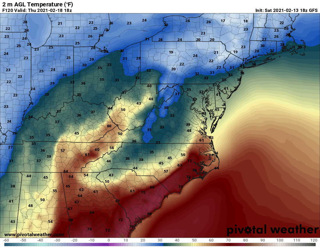
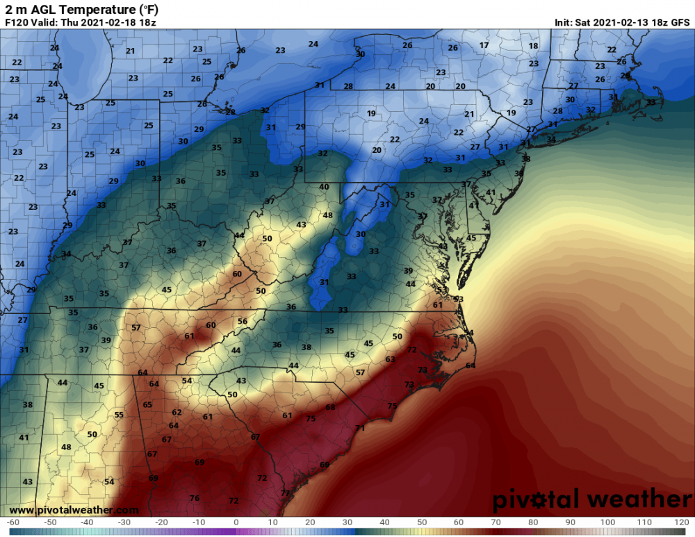
I'm going to focus on the GFS para entirely, because the original schedule would have made this the operational by now.... (The delay had nothing to do with model skill; some adjustments were needed to make it run a little faster to avoid delays for downstream systems). While it still turns everyone over to ZR/IP/RA by the end of the day 1) it comes in with an impressive thump of snow for those north of I-66 (VA) and 50 (MD) and outside the DC Beltway 2) has over 1" of liquid for the northern half of the area 3) keeps areas west and northwest of I-95 below freezing for most of the day Verbatim, it's a winter storm for most, and the northern areas (and maybe as far south as Baltimore/Howard/Montgomery/Loudoun) are still in the game for 4-6" of snow before a transition. -
Feb Long Range Discussion (Day 3 and beyond) - MERGED
high risk replied to WinterWxLuvr's topic in Mid Atlantic
Yep. Starts the day in the mid 20s and has steady precip falling with light winds - that is not going to displace the low-level cold air easily..... 00z Canadian run looks similar. -
Feb Long Range Discussion (Day 3 and beyond) - MERGED
high risk replied to WinterWxLuvr's topic in Mid Atlantic
Toss the GFS temperatures for later Thursday. The early morning temps are in the 20s, and winds are light - the GFS is always way too aggressive in weakening the damming in setups like these. The GFS para is better at retaining the low-level cold air (not great, but better than the ops GFS) and offers a colder and more reasonable solution. -
Feb Long Range Discussion (Day 3 and beyond) - MERGED
high risk replied to WinterWxLuvr's topic in Mid Atlantic
Regarding Thursday, we all know that the GFS is terrible with cold air damming, and the evaluation period for the GFS para found that it was notably better (still not great). Assuming some skill with the synoptic details, we can see evidence that Thursday will be colder here, especially in the morning hours: Not saying that this will be a snowstorm, but the chance of another ice/sleet event is probably higher than we realize right now, especially if the precip arrives in the overnight hours Wednesday.
-
One more time for those in the back: .02" of freezing rain is a high-impact event if it's in the 20's and has been for hours leading up the event. That said, there is a clear signal in the CAMs, the parent NAM, the GFS para, and the 18z GFS for sleet at the start for most of the area except for southern MD where it's all ice. Having a coating of sleet first would certainly lessen the impact of freezing rain on surfaces, although I still think that it's going to be unpleasant walking or driving tomorrow and tomorrow night.
- 891 replies
-
- 10
-

-

-
NAM and NAM nest do have a bit more precip arriving during Saturday, but it's mostly sleet until later the day. At that point, it turns to freezing rain, and there is nice slug of it in the nest over southern MD, but the precip field everywhere becomes pretty sparse by 00z. (Worth noting that the 12z NAMs were highlighting the period later Saturday night for the best ice threat. We will see if 18z continues to have heavier precip during that period)
-
Yes, and the NAM nest actually waits until after midnight Saturday night to get its heaviest precip going.
-
No need for apologies. We're all used to hunting big QPF for winter events, and seeing some models showing 0.05 to 0.1" liquid naturally evokes a 'meh'. We all just have to remember ZR, no matter the rates, is a nightmare when you have it falling with temps in the 20s onto surfaces that are "cold" going in to the event.
-
Can't emphasize enough that even .01" of ice with a cold antecedent air mass can be an absolute nightmare on the roads, as shown in Ft Worth yesterday. As noted by @chris21the 12z HRRR verbatim is certainly a high impact event - plenty cold, and modest rates (which help accretion), but plenty dangerous on the roads and sidewalks and enough total QPF to threaten some power issues in areas where some of the (patchy) higher amounts fall.
- 891 replies
-
- 12
-
-
-
Definitely worth remembering that when it comes to freezing rain and temps in the 20s, even if model QPF drops from 0.4" to 0.1", it's still a high-impact event.
-
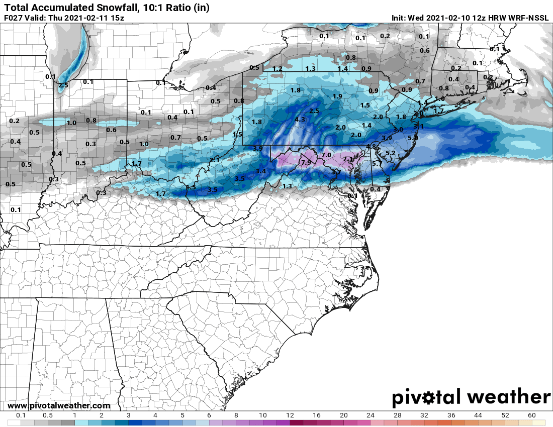
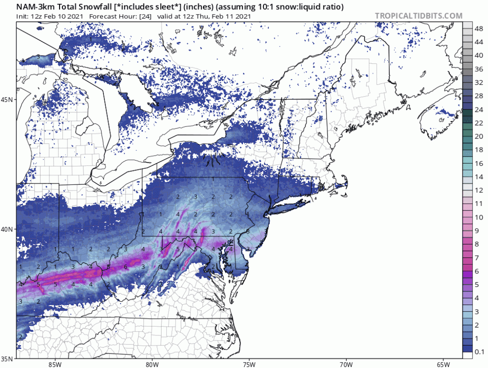
This forecast yesterday from the NAM nest (using 10:1, since snow depth maps failed due to the warmer soil leading in) wasn't too shabby:
-
huge flakes mixed in with the pingers
-
I wouldn't recommend hanging my hat on the GFS para snow maps. Maybe it's right that it will snow in DC (although there seems to be a consensus for sleet turning to rain), but it keeps the surface at 34/35. That's not going to get the job done for accumulations, even at night.
-
I do like this model, but I suspect it's a bit wet for tonight. I sure do love where it puts the heavier stripe:

-
Hug the 12z NSSL-WRF!
-
The NAM also led the way on insisting that it would be significantly warmer at the surface.
-
Really need to focus on the NAM nest over the parent here. We've seen the parent NAM be too wet in the short range for several events now, and it sure seems that way again. The nest looks far more reasonable. The nest also keeps DC and areas along and south of Route 50 as a mix going to rain, and that makes sense to me again (with the parent slightly further south with the rain-snow line).
-
This is 2 cycles in a row that it has shown this. Being at night will help overcome it a good deal, but it's weird to see the NAM be the warmest model so far for the event.
-
Their details with wave 1 are quite different, but by Friday, the Euro and NAM generally agree on the biggest totals being south of DC (and perhaps well south), with a nasty cutoff for those living further northeast of DC.
-
I sure don't hate this run.... but people in southern MD most certainly will.