high risk
-
Posts
3,276 -
Joined
-
Last visited
Content Type
Profiles
Blogs
Forums
American Weather
Media Demo
Store
Gallery
Everything posted by high risk
-

2021 Mid-Atlantic Severe Weather - General Discussion
high risk replied to Kmlwx's topic in Mid Atlantic
Same. Might as well issue the warnings for eastern Howard County now….. -
2021 Mid-Atlantic Severe Weather - General Discussion
high risk replied to Kmlwx's topic in Mid Atlantic
We’ll see what details come out of the guidance today, but this right now feels like a setup for tomorrow in which we waste really good shear with debris from a dying Midwest MCS. -
2021 Mid-Atlantic Severe Weather - General Discussion
high risk replied to Kmlwx's topic in Mid Atlantic
I'm modestly intrigued by Sunday. It's clear unclear how much instability will be available, but deep layer shear looks respectable. There isn't much agreement on how intense storms will be or what the coverage will look like, but the CAMs have overall trended towards at least scattered storms in the area later Sunday. At this point, I'd just be happy with some rain. -
2021 Mid-Atlantic Severe Weather - General Discussion
high risk replied to Kmlwx's topic in Mid Atlantic
big-time outflow boundary passage here in southern Howard County. Gusts definitely exceeding 30 mph. Not sure if I'm going to cash in on some rain. -
2021 Mid-Atlantic Severe Weather - General Discussion
high risk replied to Kmlwx's topic in Mid Atlantic
Definite competing factors today. As noted above, the instability, deep layer shear, and low-level lapse rates are really good. On the downside, low-level westerly flow here (which occurs when the surface low is well to our northeast) tends to dry out the lower levels and limit convergence along the cold front. The threat is certainly better the further east and northeast one goes, but the overall trend in the CAMs for the local area is positive, especially with the HRRR seeming to come on board this morning. -
Still a lot of activity to the west, and the HRRR is pretty emphatic that much of the area from DC north will get storms in a few hours.
-
I would think you'll cash in at some point, but it's tough to use the guidance this afternoon, as very few solutions (other than perhaps the ARW2) have a good handle on this lead line.
-
seems like at least a 2 line event. first line filling in from north of Baltimore to west of DC. Line 2 trying to form back to the west. Some guidance hints at a third line later in the evening.
-
hopeful for the scenario of one round of convection late Saturday afternoon and another during the evening hours. If that pans out, anything extra on Sunday will just be a bonus.
-
2021 Mid-Atlantic Severe Weather - General Discussion
high risk replied to Kmlwx's topic in Mid Atlantic
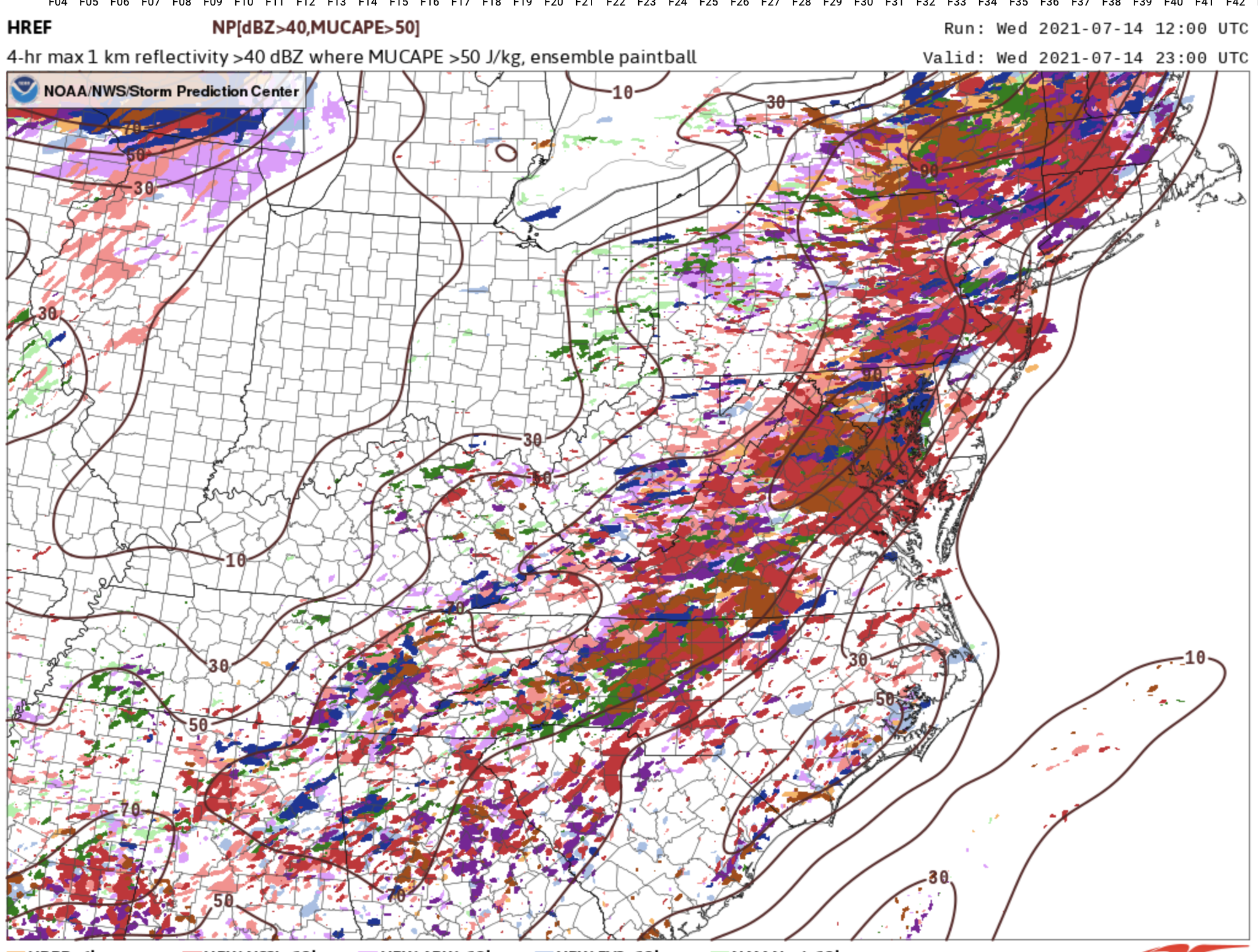
I agree with everyone that the best signals for intense storms are for DC and points south, but there are plenty of CAMs that still have 40 dbz storms north of town. It's reflected in the 12z HREF output which shows a 90% chance between 19 and 23z of 40 dbz within 20 km of a point for much of the area in: To be clear, that's a probably of a storm with 20 km of a point, so the activity could be scattered, but I'll happily take that map.
-
Interesting. The guidance had been suggesting that early evening had the best potential over north central MD, and the radar is lighting up.
-
I ended up with a nice storm with a decent soaking - definitely a win. I expected the best chance to occur around now (where there are few cells scattered to my north and northwest, but instability has been somewhat wiped out), but I didn't expect the initial afternoon cells to crank out such a strong outflow boundary that helped initiate storms further south much earlier. But ultimately, the guidance that showed storms generally staying in north/northwest of Howard and Montgomery Counties ended up being pretty accurate.
-
had lots of CGs very close - way out ahead of the rain.
-
It only took about 45 minutes for my earlier post to go to garbage.
-
The southern extent of the watch certainly matches the CAM consensus. Storms may get into the northern parts of Montgomery/Howard later this evening, but it sure seems like it will tough to get things further south.
-
Hug the Hi-Res Window ARW2. That is one of the only CAMs that have storms further south; it seems to have the best handle on those current cells you mentioned, so maybe you've got a shot.
-
Yeah, I'd feel better about storm chances today if I lived along/north of I-70, but Howard County has a shot. You're right that the best shot after today isn't until the end of the week, although there does appear to be a weak shortwave approaching later Wednesday.
-
That may very well be true, but the guidance has been pretty consistent that the threat will be northwest and north of DC Metro. In fact, I'd say that the signal for northern MD is pretty good.
-
2021 Mid-Atlantic Severe Weather - General Discussion
high risk replied to Kmlwx's topic in Mid Atlantic
about to get totally screwed in Howard County...... -
2021 Mid-Atlantic Severe Weather - General Discussion
high risk replied to Kmlwx's topic in Mid Atlantic
Definitely. Somewhat active today and then perhaps active for several days starting Sunday, but Saturday looks like a winner. -
2021 Mid-Atlantic Severe Weather - General Discussion
high risk replied to Kmlwx's topic in Mid Atlantic
Pretty clear signal for afternoon convection tomorrow, and the CAPE/shear combo currently proved would certainly suggest at least some chance of SVR. -
This cell over southern Howard is insane - blinding rain and gusts to 35 kt or so.
-
I can't speak for the Euro, but the new version of the GFS that was implemented in March showed a notable right-of-track bias for TCs in retrospective hurricane season testing, especially for those moving north and then recurving. It has been slowly adjusting to the west with Elsa's track through the southeast and Mid-Atlantic.
-
2021 Atlantic Hurricane Season Tracking Thread
high risk replied to WxWatcher007's topic in Mid Atlantic
Tornadoes are only a threat immediately along and on the east side of the track of the center. There isn't much guidance that takes the center west of the area, although some tracks are further west than others. -
2021 Atlantic Hurricane Season Tracking Thread
high risk replied to WxWatcher007's topic in Mid Atlantic
Yeah, the steering flow along the east coast in the 12z GFS has more of a southerly component than previous runs, which allows Elsa to come further west. It seems to be in response to the midwest upper trough being a little bit stronger. Will be interesting to see whether this cycle is a blip or is legitimately catching on to a trend.